Timothy Saridakis
Enthusiast
Below is the email attached sent to spotter network support.
Hello,
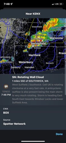
I have been a reporter on Spotter network for a fair amount of time but recently have done more professional student work in the field of meteorology. Recently I made a report to the spotter network of a Physically seen mesocyclone, with no funnel cloud. I have video evidence that this in fact was a counterclockwise moving supercell with a very decent ground inflow. Again, I have video proof. However, I was given a negative report. I can understand why the report I made can be mistaken for a radar observation, however this was a physical. In person observation made of a storm. Here is my original writing.

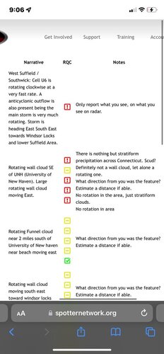
 Here was the report I made and the grading report. If you would like me to send physical video evidence and location of storm I may do so however I would very much like to point out I do not mess around with this anymore. I used to have as they call it “Shout out the obvious itis” in term making overestimated reports of “SLC- Scary looking clouds”. However I do very much think this storm could have been a threat.
Reasoning:
Observed dew points from personal weather station.
Humidity and temperature maintained during outbursts storm mode towards end of the multicellular line.
Anticyclone, and mesocyclone activity regardless of wind direction.
Observed physical south east winds mixed with a mid level shear from the north (intermittently producing cold inflows to the south south west.
Echo Tops on radar indicated 14-15km Tops, and VIL in some places of the storm that hit us producing 70kg/m^2.
Velocity radar also indicated my theory of mesocyclone activity.
This may seem very much immature at some standards, however I believe my reasoning for making this storm report was in essence a very needed report considering random and sporadic unpredictable weather conditions considering global warming.
I did not make a flood report however some property of mine was damaged with torrential rainfall.
Recap. 2011 produced an unpredictable and deadly EF3 Tornado in the Springfield area, and since the entirety of Connecticut up until Long Island NY, Albany NY, and Boston MA, makes it impossible to know when bad weather can hit especially in changing conditions.
I hope this email finds you well and I hope this gets to the right people. Please email me back at this email.
Thank you for your time.
Sincerely
-Timothy S
Please help me with this. They gave me a negative report for, and quote “Radar observations” Even though I made an in person observation and have video proof.
Hello,
I have been a reporter on Spotter network for a fair amount of time but recently have done more professional student work in the field of meteorology. Recently I made a report to the spotter network of a Physically seen mesocyclone, with no funnel cloud. I have video evidence that this in fact was a counterclockwise moving supercell with a very decent ground inflow. Again, I have video proof. However, I was given a negative report. I can understand why the report I made can be mistaken for a radar observation, however this was a physical. In person observation made of a storm. Here is my original writing.

 Here was the report I made and the grading report. If you would like me to send physical video evidence and location of storm I may do so however I would very much like to point out I do not mess around with this anymore. I used to have as they call it “Shout out the obvious itis” in term making overestimated reports of “SLC- Scary looking clouds”. However I do very much think this storm could have been a threat.
Reasoning:
Observed dew points from personal weather station.
Humidity and temperature maintained during outbursts storm mode towards end of the multicellular line.
Anticyclone, and mesocyclone activity regardless of wind direction.
Observed physical south east winds mixed with a mid level shear from the north (intermittently producing cold inflows to the south south west.
Echo Tops on radar indicated 14-15km Tops, and VIL in some places of the storm that hit us producing 70kg/m^2.
Velocity radar also indicated my theory of mesocyclone activity.
This may seem very much immature at some standards, however I believe my reasoning for making this storm report was in essence a very needed report considering random and sporadic unpredictable weather conditions considering global warming.
I did not make a flood report however some property of mine was damaged with torrential rainfall.
Recap. 2011 produced an unpredictable and deadly EF3 Tornado in the Springfield area, and since the entirety of Connecticut up until Long Island NY, Albany NY, and Boston MA, makes it impossible to know when bad weather can hit especially in changing conditions.
I hope this email finds you well and I hope this gets to the right people. Please email me back at this email.
Thank you for your time.
Sincerely
-Timothy S
Please help me with this. They gave me a negative report for, and quote “Radar observations” Even though I made an in person observation and have video proof.

