• While Stormtrack has discontinued its hosting of SpotterNetwork support on the forums, keep in mind that support for SpotterNetwork issues is available by emailing [email protected].

Atlantic Hurricanes 2025

Joined
May 21, 2011
Messages
417
Location
North-central Nebraska
Erin's extra-tropical now and did not present huge problems with US impacts, but it did grow very large.
I was wondering when the last time was that I saw an Atlantic hurricane so big near the United States.
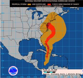
Maps below may not appear perfectly to scale, but show a couple wind histories, about 13 years apart.
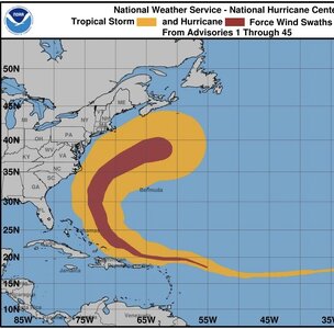
Image.jpeg
Above, in the morning, Erin's hurricane-force winds spread out up to 140 miles from center.
Tropical-storm-force winds also grew substantially outward up to 435 miles from the middle.
Screenshot 2025-08-22 at 11.34.14 AM.jpg
When have we had something as big or bigger in the Atlantic Ocean over the years?
Above, Hurricane Sandy's wind history, this areal extent goes back to October 2012.
 
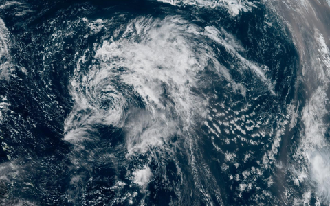
Gabrielle may well become our second Atlantic hurricane in a handful of days, but I noticed something rather amazing this morning.
Screenshot 2025-09-18 at 11.15.14 AM.png
Wind shear & dry air beat it up so badly by this morning, that for a while it may not have even been a tropical storm.
In fact, you could not find any rain associated with this "tropical storm." Convection has improved a bit since...
NHC referred to Gabrielle as a "naked low-level swirl" as seen in the above GeoColor from mid-morning.
Have you ever seen a "tropical storm" with no rain? That's kinda unusual in my estimation.
 
Gabrielle may well become our second Atlantic hurricane in a handful of days, but I noticed something rather amazing this morning.
View attachment 28154
Wind shear & dry air beat it up so badly by this morning, that for a while it may not have even been a tropical storm.
In fact, you could not find any rain associated with this "tropical storm." Convection has improved a bit since...
NHC referred to Gabrielle as a "naked low-level swirl" as seen in the above GeoColor from mid-morning.
Have you ever seen a "tropical storm" with no rain? That's kinda unusual in my estimation.
There are tropical showers present in Gabrielle's swirl, just they are from shallow TCU and CB. No deep convection due to a lot of dry and wind shear. If this swirl was in radar range, you'd see many small tropical showers in bands outlining the swirl very well.

It can be debated if Gabrielle was classifiable as a TC at this point.

Since late this afternoon, a large area of intense thunderstorms w/ cloud tops as cold as -85 C has blown-up NE of the center. That doesn't mean intensification though. The convection is more baroclinically-driven than tropical as an upper-level jet streak is over the Gabrielle. You see this a lot w/ heavily sheared systems (waxing and waning blow-ups).

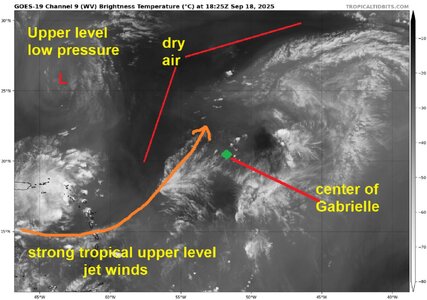
Attach is a WV image from earlier today that I annotated for another group. What a mess! You can't even tell there is a TC present b/c as noted, it is just low-level swirl, and WV shows mid-levels of the atmosphere.
 

Attachments

  • wv1.jpg
    wv1.jpg
    213.9 KB · Views: 2
It can be debated if Gabrielle was classifiable as a TC at this point.
...tropical showers present in Gabrielle's swirl, just they are from shallow TCU...
I agree; thanks for that.
The shallow, tropical showers of the "tropical storm" weren't showing up on the infrared, satellite images
as the deeper convection might. Interesting feature to watch, even if it's not a threat to the United States.
 
I agree; thanks for that.
The shallow, tropical showers of the "tropical storm" weren't showing up on the infrared, satellite images
as the deeper convection might. Interesting feature to watch, even if it's not a threat to the United States.
The TCU/small CB in this case may not even get to 25,000 ft, so they won't show up as well on IR for cold cloud tops. Plus they are small, and the max resolution or GOES IR is 2 km. In many cases, the TCU/CB are not even glaciating so no cold cirrus canopies.

Technically, if a TC has no deep convection anywhere near the center or in outer bands, it does not qualify as a TC. The general rule though is before it get declared post or extratropical, it has to be largely absent of deep convection for 12 hr. This is done b/c many times a system may be absent w/ deep convection for several hours, and then you'll get a large blow-up of convection, esp. w/ a sheared system. This is what happened w/ Gabrielle late this afternoon, so NHC does not want bounce back and forth calling something tropical then not tropical and then back again until some persistence is observed.
 
__________________________________________________________________________________________________________________________
Image.jpeg
___________________________________________________________________________________________________________________________
Image 2.jpeg
_______________________________________________________________________________________________________________________
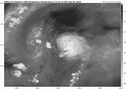
Water-vapor image, TC doing better this morning, 45-knot storm-intensity per NHC, but...no tropical-storm-force winds on the western side.
 
Last edited:
"Water-vapor image, TC doing better this morning, 45-knot storm-intensity per NHC, but...no tropical-storm-force winds on the western side."

A storm does not have to have symmetric tropical storm-force winds all around the center to be called a tropical cyclone. Sheared systems are like this a lot, and Gabrielle was no exception.

Practices vary around the world. In NHC's AOR, all that is required is a small area of tropical storm-force winds in any quadrant for a system to be named. In the Australian region, tropical storm-force winds must be more than halfway around the center before it gets a name.
 
Back
Top