Another Fatal, Poorly Warned Tornado

Was just talking about that on another forum. Looks to be heading right for Louisville.

I could be mistaken but it looked like there was a TDS with the earlier tornado with that storm near Alfordsville, IN before the warning went out. Warning was also never changed to TORR/"radar confirmed" status despite a clear TDS.
 
WDRB now advising people near the path of this storm (and a second one back over near French Lick) to take their tornado precautions, despite the absence of a NWS tornado warning.

LVX_2131.png
 
WDRB now advising people near the path of this storm (and a second one back over near French Lick) to take their tornado precautions, despite the absence of a NWS tornado warning.

View attachment 24045
This is happening more and more across the nation. I strongly salute the TV mets who are doing this.

Now, I think the extent of the problem is becoming clear to the readers of this board.
 
Yeah. I used to be one of those "weather weenies" who considered criticism of the NWS/NOAA to be almost verboten, but there are enough examples now that it's clear things have regressed considerably within the last 10-15 years, which is also the period that coincides with most of my weather-observing adult life.
 
Louisville got lucky thanks to stabilization from earlier convection, but seeing second (or technically third)-hand reports on another forum that the Alfordsville tornado caused a fatality. Will warrant further examination if confirmed...

 
I wonder if current weather patterns producing fewer tornadoes is also contributing to the problem? Depending on shifts, it's conceivable a NWS meteorologist could only issue a tornado warning maybe once or twice a year, if even that.
 
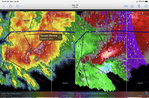
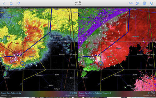
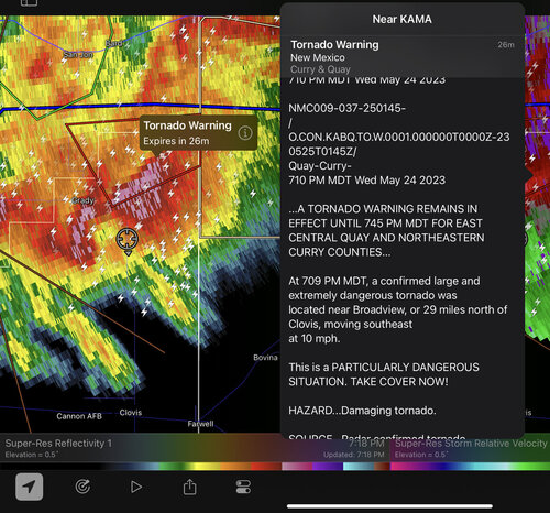
@Mike Smith I was particularly interested in the images you posted in which the velocity couplet is outside of the warning polygon (post #17 in this thread). I noticed a couple of similar issues while chasing the tornadic supercell near Grady NM on May 24 of this year. I assumed it was just a RadarScope issue, causing the display of the polygon to not be timely, or properly synchronized with the radar.

In the first image below, the location cited in the warning is correct, but it lies in the extreme southwestern corner of the polygon. The warning puts the motion as southeast, yet that is not the way the polygon is oriented. With a southeast motion, the meso would almost immediately move out of the polygon.

The second image shows that, sure enough, the polygon is no longer encompassing the meso.

The third image is about an hour later. A new warning polygon, but again displaced from the meso.

I had been planning to pose a question about all this as a separate thread, but I thought it was appropriate to include it here, given your similar post #17 in this thread. I now think it truly could have been an error, not a RadarScope issue!

IMG_1774.jpegIMG_1775.jpegIMG_1776.jpeg
 
Jim, I had been watching the Indiana storm in question. It was in the polygon and moved out. If they didn't want to continue that tornado warning, that's fine (I disagreed) but then the polygon should be cancelled.

With regard to the above image, let me convey a thought: While the public would have the meso discussion turned off, look at that. How is the public supposed to make sense of all of the overlapping polygons and lines? The NWS is supposed to cancel invalid warnings. Instead we get these messy images that, I contend, fail to communicate the location of the genuine threats.
 
Last edited:
I wonder if current weather patterns producing fewer tornadoes is also contributing to the problem? Depending on shifts, it's conceivable a NWS meteorologist could only issue a tornado warning maybe once or twice a year, if even that.

Warren, that is an issue. However, I think training is the bigger issue. Consider that 2011 was tornado after tornado after tornado. Yet the numbers went down in 2012 (an above average year) after all of the experience gained the previous year.

That is one of the reasons WeatherData, Inc./AccuWeather Enterprise Solutions was so good. In addition to all of the training and testing, we were issuing warnings for the entire nation from one location with the same group of meteorologists.

But take a look at the accompanying image of the hook echo associated with the Joplin Tornado. How in the world did they get the idea it was Carl Junction that was threatened rather than JLN? Given all of the issues that we have discussed, what is to prevent another tornado causing 100+ fatalities in a city due -- in part -- to screwed up warnings?

We have to have a National Disaster Review Board.
 

Attachments

  • Screen Shot 2023-06-26 at 10.17.25 AM.png
    Screen Shot 2023-06-26 at 10.17.25 AM.png
    1.5 MB · Views: 0
Jim, I had been watching the Indiana storm in question. It was in the polygon and moved out. If they didn't want to continue that tornado warning, that's fine (I disagreed) but then the polygon should be cancelled.

With regard to the above image, let me convey a thought: While the public would have the meso discussion turned off, look at that. How is the public supposed to make sense of all of the overlapping polygons and lines? The NWS is supposed to cancel invalid warnings. Instead we get these messy images that, I contend, fail to communicate the location of the genuine threats.

Mike, it sounds like you are assuming that the warning was correct at one point, but then became invalid and wasn’t continued or properly cancelled. But I’m suggesting the problem is worse, because the warnings weren’t invalid. That storm in NM on 5/24 had a confirmed tornado, so the polygon should have been extended. I think it was in the wrong place to begin with, because that was the first polygon that appeared, and the meso was already in its southwest corner and moving out of it. In any case, it should have been extended as the storm moved south.

Then, in the third, later image, maybe the polygon shown had become invalid, but that should have been extended also. As I drove through Farwell, the inflow was quite strong, and sirens were blaring - so someone thought a tornado warning was needed, regardless of where the polygon was shown.
 
Back
Top