• A friendly and periodic reminder of the rules we use for fostering high SNR and quality conversation and interaction at Stormtrack: Forum rules

    P.S. - Nothing specific happened to prompt this message! No one is in trouble, there are no flame wars in effect, nor any inappropriate conversation ongoing. This is being posted sitewide as a casual refresher.

Another NWS Warning Miss on an Obvious Tornado

Joined
Feb 19, 2021
Messages
525
Location
Wichita
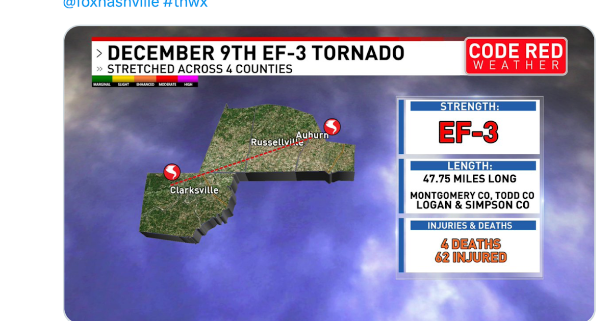
I wish I didn't feel I have to post these but here it is: www.mikesmithenterprisesblog.com/2023/12/it-happened-again-strong-tornado-on.html The first tornado of yesterday's Tennessee Outbreak had a negative warning lead-time of 14 minutes! Please keep in mind the NWS's published goal is +13 minutes, which the agency routinely attained from 2000 to 2011. They haven't performed at that level since fiscal 2012!

Because this group is more knowledgable than the general public, I wish to solicit (hopefully) knowledgable comments as to what has gone wrong?

I had another retired NWS meteorologist contact me last week (the third) and tell me the issue is training. I'm certain that is part of it. However, I wonder if it is more than that; perhaps the loss of experience and expertise from my generation of meteorologists retiring. I certainly feel I benefited from having to learn:
  1. Black and white radar.
  2. Color radar.
  3. Color radar with time-lapse.
  4. Doppler radar.
  5. Doppler radar with dual-polarization
I wonder if today's meteorologists, who start with #5, are at a disadvantage? I don't know.

What else do you believe may be contributing?

Thank you.
 
I don’t feel qualified to speculate, but it’s hard to believe the issue is training, when looking at velocity images as clear as the ones you posted in your blog. If I, as a relative layman, can see it, how can a professional meteorologist, even if on his or her first day on the job, not see it? And isn’t there an “alarm” of sorts that sounds an alert based on TVS parameters?
 
I don’t feel qualified to speculate, but it’s hard to believe the issue is training, when looking at velocity images as clear as the ones you posted in your blog. If I, as a relative layman, can see it, how can a professional meteorologist, even if on his or her first day on the job, not see it? And isn’t there an “alarm” of sorts that sounds an alert based on TVS parameters?
Jim, there used to be an alarm when a TVS was detected as was the case Saturday morning. I don't know if that alarm still exists.
 
So, I have both a question and some speculation. Both go to the question of "training", but in different ways.

Question first. The summary statistics definitely suggest a problem. But--which (if any) are the offices with good warning records? Say, set a minimum threshold for potential events and then pick the best performers. What (if anything) are they doing differently? It may be the distribution is uniformly poor, in which case that tells you something as well.

Speculation second. Actually, I’m not going to speculate. I have no idea what the forecasters are facing. I just have more questions. Is it information-overload with multiscreen dashboards offering every kind of numerical view into the weather data, taking too much time to assimilate when minutes count? Or automated decision-making algorithms that are really no better than the programmers who designed them? Or a curious mixture of both: a workflow that might actually slow learning the art of tornado forecasting by relying too much on technology.
 
Hi Jeff,

Thanks for your comment. FYI, none of the cases I have cited are QLCS or otherwise brief tornadoes.

Below, in reverse chronological order starting with last Saturday's busted warnings in Tennessee, are missed tornadoes since April 30, 2023. Of course, there are more if we go back farther but this should give you and other StormTrack members an idea of the tornadoes I am complaining about.

We had two brief spin-ups here in Alabama


Hard to warn for these types…
 
Here we go again!
Another tornado warning miss -- this one in the Myrtle Beach area earlier this afternoon.
Today's was in the Myrtle Beach area.
 
I think the problem lies more with the lack of staffing of the local wfo facilities, kinda like what is happening with the increase of "near misses" with air traffic either on the ground or in the air near airports.... as allegedly the air traffic control towers are the most understaffed than ever before. That goes back to compensation paid for doing a job, the government does not want to pay what the forecasters want to be paid, so the very experienced quit and go on to other things, making more workload for those who remain, and the low compensation amount cause people who are qualified to not be interested in filling the vacant positions, also look how many military personnel, and at least in Chicago Illinois, and the state of Illinois in general has a shortage of police officers due to the medical requirements and vaccination requirements since the federal government allowed states and agencies to require vaccination to accept or continue employment and people are realizing not only is it unconstitutional to mandate physical examinations and vaccinations, these recent vaccinations are just plain dangerous. Also COMPENSATION AND RESPECT are major considerations for most people who are either employed or considering employment with a company or agency. The weather has been becoming more active and more severe earlier in the year..... and a shortage of employees cause more work load and stress on the remaining employees, which in turn lead to unfortunate mistakes being made.
 
Back
Top