• A friendly and periodic reminder of the rules we use for fostering high SNR and quality conversation and interaction at Stormtrack: Forum rules

    P.S. - Nothing specific happened to prompt this message! No one is in trouble, there are no flame wars in effect, nor any inappropriate conversation ongoing. This is being posted sitewide as a casual refresher.

Huge NWS Tornado Miss Friday Evening in Ray County, Missouri

Joined
Feb 19, 2021
Messages
549
Location
Wichita
It has happened again -- and will continue to happen (with another Joplin inevitable) -- until some outside force gives the NWS no other choice but to act.

Here is this evening's story of the major tornado miss (TVS + lofted debris) in Ray County, Missouri, about 35 miles northeast of downtown Kansas City.
Baring MO in Knox County. NE MO. Unwarned tornado struck around 1130pm CST Friday night. No WEA, weather radio alerts or siren activation. Fortunately, only minor injuries.
 
Baring MO in Knox County. NE MO. Unwarned tornado struck around 1130pm CST Friday night. No WEA, weather radio alerts or siren activation. Fortunately, only minor injuries.

Of course, 11:30p = 12:30a this morning and you are correct.
Screen Shot 2023-08-05 at 10.27.27 AM.png
While I do not give them a "pass," I give STL NWS a lot of slack on this one. Baring is 133 miles from the WSR-88D and the beam's center is more than 15,000 above the ground. The rotation is strong (for the distance) but broad (below).

However, I do strongly criticize NWS/NOAA HQ for turning down Congress' offer of plugging radar gaps. This was one of the areas that was on the list to get a C-band radar (like the TDWR's). https://www.washingtonpost.com/weather/2020/11/21/radar-gaps-weather-service/

NWS HQ can dissemble all it wants but places 120+ miles from the nearest radar will have inferior warnings.

Screen Shot 2023-08-05 at 10.33.40 AM.png
 
Mike--I'm a senior policy adviser for my district state senator, so I am used to thinking about this stuff from the point of view of "legislative policy" vs "administrative code", etc. If I write to my congressman, I need to be able to recommend a solid policy solution. Otherwise I will be left with "what the aide who really reads this stuff" decides to do with it.

I should probably read your posts on this before asking this question, I guess, but here goes: "What would be your suggestion for a process and expected outcome?"

Please read my post but I am happy to answer your question.

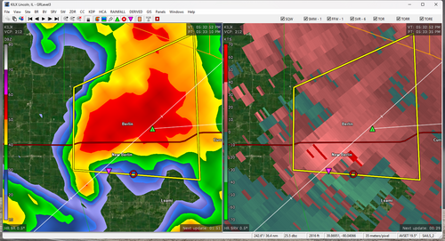
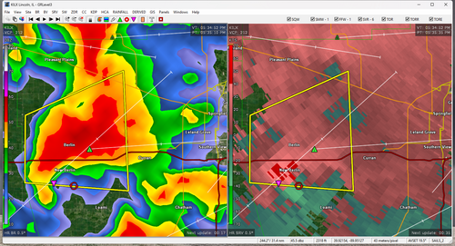
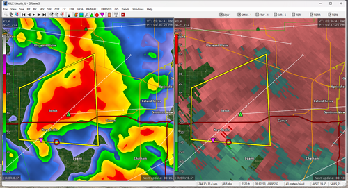
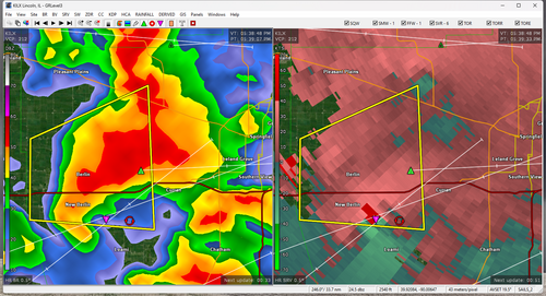
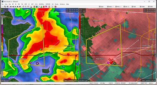
For all intents and purposes, the NWS, FEMA, Red Cross, emergency management have no real accountability because they can spin BS to the politicians and, because the politicians are not scientists, they generally get away with it. FEMA has been accused with everything just short of criminal negligence in the aftermath of the hurricane in Lake Charles. Are those accusations fair? I have no idea.

That lack of accountability has to change.

Since 2012, in the wake of the Sandy mess, I have been proposing a National Disaster Review Board (NDRB) modeled after the hugely successful National Transportation Safety Board. These experts in the field would do things:
  1. Review disaster failures and success by all involved parties.
  2. Assume the responsibility for keeping accuracy stats of NWS storm warnings. This NWS being in charge of the warnings, the verifications, the warning database, and the warning stats is incestuous and needs to stop.
In my mind, the NDRB would be forbidden to bring climate change into things. The USA already has two climate change panels and we do not need a third. They need to strictly focus on disaster response and improvement. They must have subpoena power so the agencies cannot thumb their noses at them.

I am a Reagan conservative and am strongly for a smaller, but better, government. It nearly kills me (instinctively) to propose another government agency. But, going back to Joplin (poorly warned, with 161 dead) and Sandy, the need has become obvious: It is Time for a National Disaster Review Board, Part I

That is my suggestion. Thank you for asking!

Mike

P.S. To the meteorologists on this board: Do we want our science, our profession to be tarnished by these terrible performances? Our science is much better than this! That is yet another reason to write congress to ask for change.

We also need to burnish our radar skills if we are in the media. If the NWS is dropping the ball, we have a professional obligation to to inform viewers and listeners of dangerous weather.
 
Last edited:
There are two twists to the story of the Baring Tornado miss. My full, preliminary, report is here: The Second Missouri Tornado Warning Miss of the Night!

Please, please use your congresspersons' web sites to notify your congresspeople to act on this.
Of course, 11:30p = 12:30a this morning and you are correct.
View attachment 24183
While I do not give them a "pass," I give STL NWS a lot of slack on this one. Baring is 133 miles from the WSR-88D and the beam's center is more than 15,000 above the ground. The rotation is strong (for the distance) but broad (below).

However, I do strongly criticize NWS/NOAA HQ for turning down Congress' offer of plugging radar gaps. This was one of the areas that was on the list to get a C-band radar (like the TDWR's). https://www.washingtonpost.com/weather/2020/11/21/radar-gaps-weather-service/

NWS HQ can dissemble all it wants but places 120+ miles from the nearest radar will have inferior warnings.

View attachment 24184
I'm generally pretty satisfied with the way LSX performs but this seems like a case where erring on the side of caution would have been a better idea considering that it's a night situation, the radar distance, and poor to non-existent spotting conditions.
 
I'm generally pretty satisfied with the way LSX performs but this seems like a case where erring on the side of caution would have been a better idea considering that it's a night situation, the radar distance, and poor to non-existent spotting conditions.

Matthew, as I can't tell for certain whether you read my piece on the second tornado miss, please read it if you have not. I say,

It was the responsibility of the St. Louis NWS office to warn Baring. I am going to give them a fair amount of slack as the responsibility for this situation belongs to NWS Headquarters.

Still, there is more to the story than you might think. Thank you.
 
Don't know if this actually produced but I certainly would have given it a tornado warning about 20-30 minutes ago. Keeping in mind that the GR Level 3 color table (at least the one I use) doesn't run as "hot" as that on RadarScope, so weaker couplets don't show up this clearly.

Not only was it not tornado warned, it's barely within the SVR polygon.
 

Attachments

  • ILX_2232.png
    ILX_2232.png
    712.2 KB · Views: 0
  • ILX_2234.png
    ILX_2234.png
    754.5 KB · Views: 0
  • ILX_2236.png
    ILX_2236.png
    742 KB · Views: 0
  • ILX_2238.png
    ILX_2238.png
    739.9 KB · Views: 0
  • ILX_2240.png
    ILX_2240.png
    745.6 KB · Views: 0
Mike Smith said:
However, I do strongly criticize NWS/NOAA HQ for turning down Congress' offer of plugging radar gaps.
Question is why did they turn down the offer?
Is it due to the cost of operating/maintaining additional radars.
Cost of labor to run/maintain them?
Something else?
 
Back
Top