9/13/05 REPORTS: Plains through western Great Lakes

Joey Ketcham

Had a pretty nice chase....

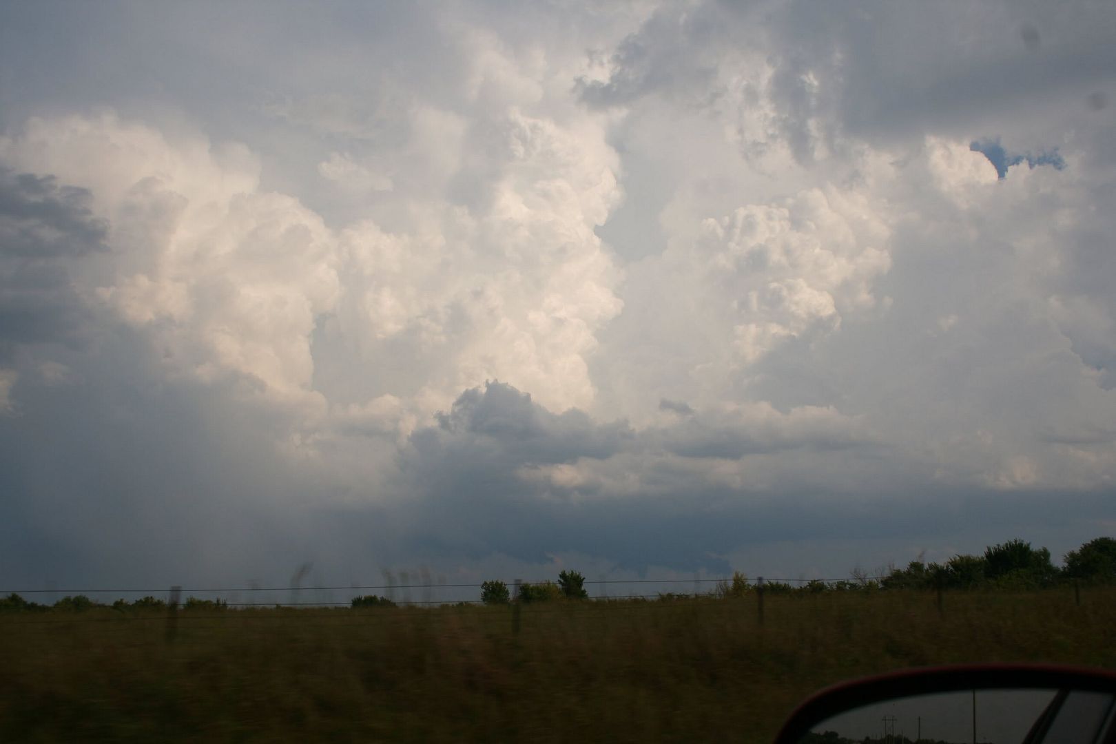
Springfield NWS issued a tornado warning close to 5:00 CST for Crawford County.. I left work at 4:55 and headed north on highway 69 towards Arma knowing that I would be able to intercept this storm.

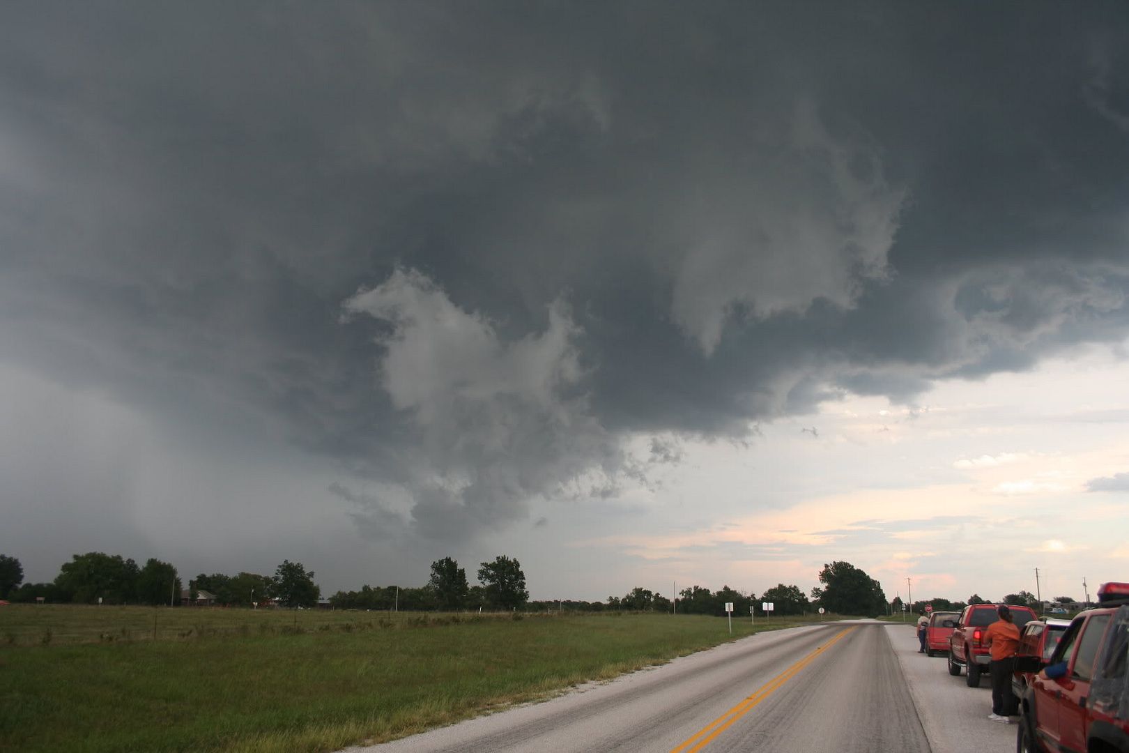
I got to Arma around 5:20ish where I watched a nice wall cloud pass over Arma/Franklin KS with some very nice rotation... I follwed it back east with it just to my north also moving east. As the storm neared Missouri it seemed to lose organization and appears to be dying out. I called it off in Mulberry Kansas....

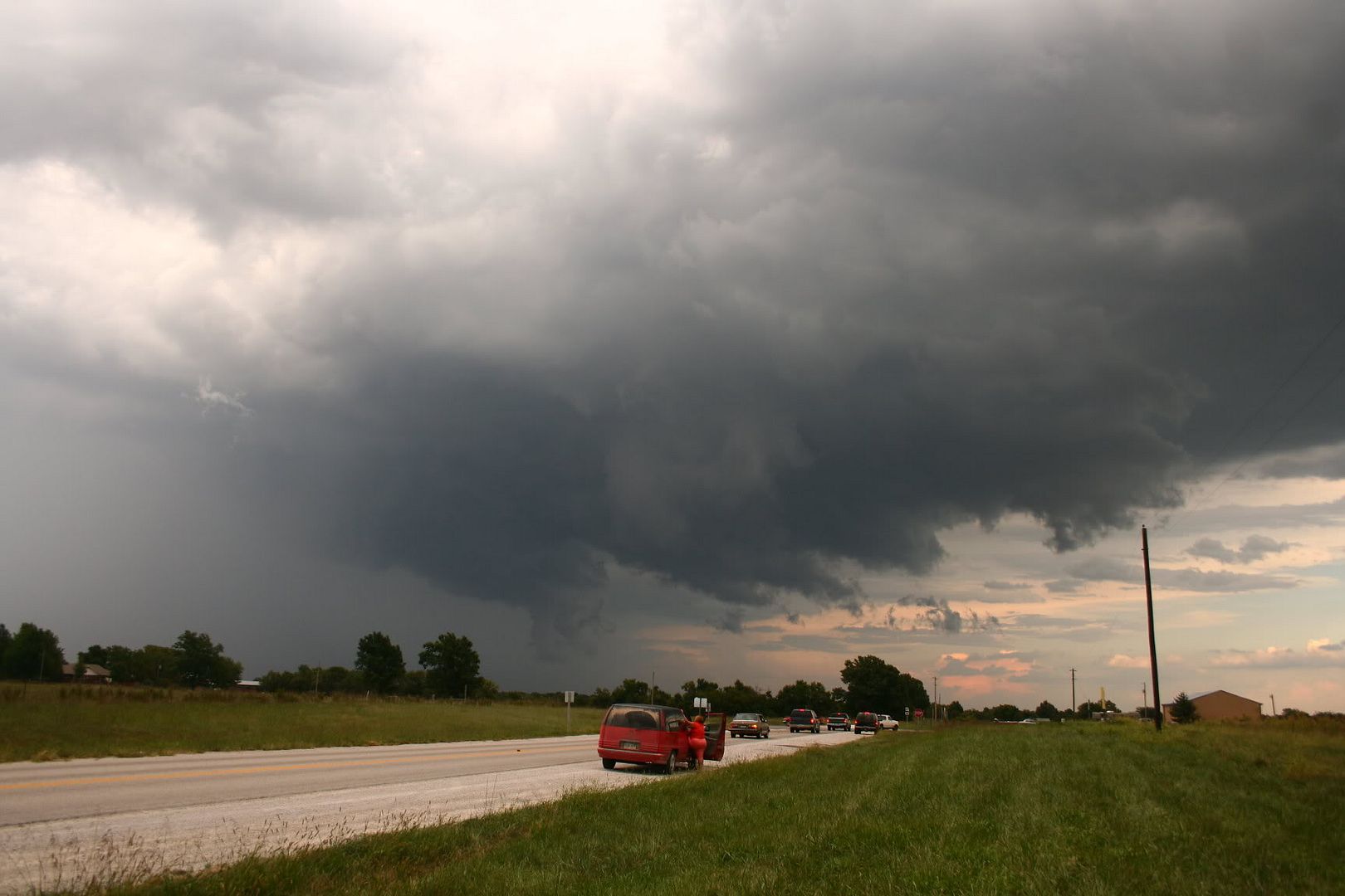
I talked to fellow storm chaser Russel Parsons on the phone, he continued to follow the storm over into Barton County where he said it began reorganizing itself and once again picking up in rotation. No touchdowns, but very nice and very well defined wall cloud. Definately made for a very nice late-season chase given the hot, dry, non-stormy weather we've been having...

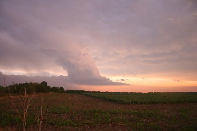
Unfortunately because I was at work when I left, I didn't have my new Canon XL1S with me, which would had made for nice video.

All in all, can't complain. Now I'm watching the storms out west in Wilson, Neosho, and Montgomery counties.....
 
Since I did not want to start an entirely new thread for Wisconsin, I will go ahead and post my account here so as not to clutter up the forum...

I didn't actually go storm chasing here since this was a straight-line wind dominated event. The storm came right to me so I didn't really need to worry. It started out as kind of a weak cell in Southeast Iowa and then eventually tracked up through Northern Illinois and into Southeast Wisconsin along I-43.

The storm must have been moving real fast (50-60 MPH...similar to NWS Warning Text) because the skies darkened almost immediately in advance of the beginning of the 15-25 MPH gusts and the lighter precipitation. It gradually got gustier into the 55 to 65 MPH range with sustained winds probably around 30 MPH and I thought, "Oh this can't be the worst of it, they were warning for winds in excess of 70 MPH". About 20 seconds after that thought crossed my mind, the brief period of violent gusts (about a minute in duration) proceeded with gusts easily over 70 MPH. I estimated 80 MPH just because of the way everything was bending and twisting. It seemed almost like a microburst because I could see a white sheet of rain descending in torrents about 100 yards southwest of me before the onset of the strongest winds. Anyways, lots of crap went flying off the trees and about five very sizable branches flew off in my yard. The lightning was incredible, I'd say about 10 CG's within a mile or two of my location, scared the bejeezus out of me.

After the storm I drove around...

Streets are full of leaves and twigs and other assorted crap (like trash can lids). Branches are down all over the place although decidedly more in certain locations (microbursts?). Some trees I saw were just snapped off but others were split in two, as if one side of the foliage caught the wind and the whole tree twisted. Several houses had near escapes with very large, old trees falling very close to the structure. Also, saw a lot of police, ambulances and fire engines racing by so I'm thinking some trees did catch some houses or lightning hit something :( Also we had an injury in Walworth County when a tree hit a motorcyclist.

Unsure on the extent of damage around the entire town, but from what I heard from other people, not many areas escaped at least some damage. Apparently the railroad tracks at one location were blocked by the gates (either disabled with the multiple brief power outages or blown over and now in place because of the winds) and someone had to hold them up so people could pass.

Worst storm I've had since July 21, 1998 when I was in a 100-110 MPH microburst wind gust in Kenosha Co, WI. (Now In Waukesha Co).

...Alex Lamers...
 
Crawford County Kansas & Barton County Missouri Chase

**Updated with links to photos and chase account

I chased the tornado warned cell that moved from northwest of Girard, Kansas and dissipated approximately 2 miles North of Lamar, Missouri, located in Barton County Missouri. The storm started producing a well-defined rotating wallcloud approximately 2 miles northwest of Girard, Kansas, located in Crawford County. The tornado warned cell was moving straight east and at speeds of only 20-25 MPH. It was very easy to keep up with, while driving on the dense network of gravel roads in this area. I continued following the rotating wallcloud eastbound, as it passed over the towns of Arma, Kansas and then later Mulberry, Kansas.

There was a lot of upward motion into the updraft, with a lot of scud clouds being taken up into the storm. At no time did I see any funnels or tornadoes with this storm. I followed the storm into Barton County Missouri, where the rotating wallcloud finally died near NW 20th Road and U.S. 71 Highway. Hopefully I will get a full report and additional pictures uploaded to my website sometime tomorrow. This was a really fun chase, as I wasn't really expecting tornado warned storms to roll through my neck of the woods.

All Photos Of This Event Can Be Found Here.
http://www.russparsonspictures.com/2005091...13Chase/?page=1

Chase Account Can Be Found Here.
http://seksweather.blogspot.com/2005/09/tu...torm-chase.html

9219_1024.ts1126667191571.jpg

This image was taken approximately 1 1/2 miles northwest of Girard, Kansas. The wallcloud had just developed, and the storm became tornado warned at this time.


9227_1024.ts1126667252946.jpg


I was approximately 3 miles east-northeast of Girard, Kansas and I was looking west. The wallcloud was rotating rapidly at this point, and continued moving straight east.


9256_1024.ts1126667297805.jpg


This photograph was taken at the intersection of NW 20th Road & U.S. 43 Highway East of Liberal, Missouri. The wallcloud had fallen apart just before this photo was taken, but redeveloped and was rotating again at this location. Movement was still east at about 15 MPH.


9289_1024.ts1126667352055.jpg


This photograph was taken approximately 10 miles Northwest of McCune, Kansas. These mammatus clouds were attached to another tornado warned storm located in northern Montgomery County Kansas, later in the evening as the sun was setting. This was the second bunch of storm that rolled through the Southeast Kansas area.
 
I chased in central MO today. Yet another lesson about chasing in Missouri, i.e. no matter how badly you are tempted, DON'T DO IT! :evil: Hills, trees, bridgeless rivers, trains that hold you up at crucial times - I saw it all today!

The RUC was showing good CAPE and decent directional shear, with southerly surface winds, likely to set up in central MO by later afternoon, but then the 16:30Z SPC outlook showed some interest in NE MO. I debated the two areas, but just before I headed out, decided to stick with central MO, as isolated cells were already forming there down the line from the more numerous ones that had broken out in NE MO. (Good decision, since the stuff in NE MO quickly lined out.) I headed out around 12:30, and promptly lost a half hour due to construction in the St. Louis area (another reason to avoid MO, at least if you live in IL!). Stopped for a data check at the Flying J west of Warrenton, noted an isolated cell at the western edge of Montgomery Co and a stronger one approaching Lake of the Ozarks. Checked out the Montgomery Co one, but it crapped out, so I pushed south through Herman and west on route 100 - which must be the slowest, hilliest, curviest road I have ever been on in a chase. Then, when I thought it could not get worse, the train! (At least it gave me some time to study the maps and plan my intercept route based on the warnings I was hearing on the Lake of the Ozarks storm, which continued to strengthen).

I had figured that the storm, though reported moving NE, would pass south of Jefferson City, which is why I crossed the Missouri River at Herman. Now the movement was reported as east. Up to around 4, all of the reports were of movement between 15 and 25 mph, so I figured I could intercept the storm by heading west from route 100 on route 50, then south on 63 for an intercept west of Freeburg or Vienna. However, after 4 I began hearing reports of movement at 35-40 mph, and when I heard in Feeburg at 4:20 that the storm would reach Vienna by 4:30, I knew I was S.O.L.

The storm had ragged lowerings on the SE side, and although movement was reported as east, it really appeared to me to be moving SE. By the time I was halfway between Freeburg and Vienna - and hearing that the wind was estimated at 70 mph with penny sized hail, I could see that the storm would beat me to Vienna and I could not safely punch through - in a wooded area, I don't want to mess with 70 mph winds. And by now it really had that look - a lowering halfway to the ground (shelf cloud, I would guess, but I was at the wrong angle to tell for sure what it was) and a rain foot surging ahead of the storm in the direction it was moving, it looked every bit as nasty as it was reported. So, as I entered the first of the heavy rain and wind, I reluctantly turned around. Never even got a picture, as up to the minute I realized I had to turn back, I was hustling to beat the storm.

I went back north to route 50, hoping I might get back ahead of the storm for another look as I headed back east. But it was not to be. As I suspected, when I got home and looked at a radar loop, it confirmed that the storm had started moving NE, then turned SE, producing wind damage and some hail from the Lake of the Oazrks area all the way E then SE to Steeleville. It seemed to start out as a supercell, then evolve into something like a supercell imbedded in a line of weaker storms - but it did seem to become more of a forward-propagating, outflow-dominant storm around the time I got within range of it, which probably accounts for the acceleration and SE motion. If I had not had the construction or the train, and if I was not so hopelessly road-screwed (as always seems to happen in central MO), maybe I could have gotten ahead of it, but this day that was not to be.
 
I was on the tornado warned storm in Elk county Kansas. When the storm first went tornado warned the updraft base was exhibiting decent vertical motion, but there was not any noticeable rotation. Here is a picture shortly before the storm went tornado warned.
my.php

About thirty minutes after the tornado warning was issued the updraft base began to lower, but there was still not significant rotation. Here is a picture of the lowering when the storm was about 10 miles West of Longton.
my.php


Shortly after this picture, the updraft base began to show good rotation. I saw that there was a tornado reported on SPC storm reports 2 miles North of Longton. I never saw it, but there was rain falling in the updraft region and I was driving most of the time so I could have missed it. It must have been just a quick spin-up though because there were never any persistent lowerings. I wasn't expecting much today so I was fairly pleased with the chase. Hopefully tomorrow will bring some tornadoes.
 
Not a bad chase day, esp. being that it was September. Left Tulsa around 4 expecting storms to fire in Southeast Kansas. Initially targeted Caney, Ks just north of the state line. The first storm I was chasing in Montgomerey County fizzled out so I decided to head west anticipating more initiation. Sure as heck didnt expect to see any tornado warned storms today for sure, but I was desperate for even some severe storms with some nice structure to look out. Needless to say when I heard the torn. warning for Elk Co. come over the radio I got excited (was only about 15 miles from the storm). Intercepted somewhere around the town of Howard in the absolute middle of nowhere. Only thing around were some cows staring at me along the fence line. Saw a beautiful rotating wall cloud and continued to observe it for about 30 minutes. Nothing ever came of the wall cloud, maybe a couple of funnels trying to get going way up, but I can say for sure to be honest. Back tracked the rotation to the East when I came up on Neodesha where the sirens were blaring. Headed east from there and it quickly began to get dark and started to rain and any contrast to see the storm was gone. If there was any rotation at this time I think it may have been rain wrapped. From this point I decided to head home. About 5 miles east of Neodesha I ran into nickel sized hail and about 60 mph winds whipping across the road and I was in the middle of nowhere. This is probably the most frightened I have been during a storm chase. A few miles down the road a tree was blocking the road and I barely made it through. I ran into a couple more storms with 60 some mph winds and hail on the way home. Definitely an excellent chase day! Hell, there was no way I was really expecting to be on a torn. warned storm, but I was bored so thought what the hell I will go chase. I was surprised and really glad of the outcome to say the least. Would have been nice to see a nader, but oh well it is Sept. and who am I to complain :D
 
A couple reports of up to baseball size hail in some areas in and around Crawford Co.. My sister in law got major hail damage when she passed through the storm coming back from Ft. Scott.
 
The Wisconsin event appears to be derecho-like in nature --- high, straight-line winds across an area over 100 miles long. If you look at the SPC's reports page for 9-13, you'll see a string of high-wind reports that stretches along a bow from E central Iowa all the way up to Green Bay.

BTW, the winds came through Oconomowoc at about 6:00 PM. I'd guess 45-55 knots here for a couple minutes. Minor tree limb damage.
 
Just as a friendly reminder:

Originally posted by Map Room Rules
(4) Types of messages. Map Room allows three types of messages, as follows. TALK is no longer permitted.

* REPORT is reserved for your storm chase reports and photos ONLY. This is where to go to tell us how your chase went! Hearsay, secondhand reports, and spotter and media reports are not allowed in REPORT; they belong in NOW.
--> Map Room Rules -- MANDATORY READING
 
Well, since I didn't get around ANYWHERE until after 5:00 p.m. it was a long evening for me.

Took off north on I-35 to US 166 and watched the formation of some of the later storms to affect the Cowley and Elk counties. I looked andtried hard to make a decision. Couple this with the fact I didn't want to get to far out of my Radio Area with the Kay County Fair just starting up. I didn't have any information other than what I heard on the radio stations and NOAA weather Radio.

I kept looking back to the south watching a tower forming really hard in the Enid area that looked to have some potential to move closer to home. Bad mistake here. I cut back south to Blackwell, OK when the storms in Cowley County were TOR warned. Could have, Should have, Would have....

After consulting with a couple of folks that WERE looking at radar, I decided to cut back up to Kansas. There was a fairly strong storm in the Dexter KS area and it looked like I might be able to intercept that one before it got away from me and it got too dark to travel that far. This storm was SVR warned several times that I remember hearing and when I got to it, it had some very nice structure. Driving from Arkansas City, KS the Anvil was simply spectacular. NOW! I wished I had moved directly on this storm. Anyway, I got in just south of Dexter, Ks on US 166 and KS 15 and just watched this small storm evolve. It showed some promise a few times with some rapid rotation, an inflow notch, and lots of CG Lightning, but finally blew itself out dropping tons of rain on the rural landscape. As it was starting to get dark, I decided it was time to head on home.

On the way to Shidler, OK, I got a call from the Radio Station asking me to take a look in the Perry, OK area as there were a couple of SVR warned storms in that area. OH Boy! Another long drive! In Shidler I stopped for gas and was surrounded by a bunch of the local teens, all asking all sorts of rapid fire questions. It was interesting to take a look where I could see both storms in progress and having almost clear skies above me. The structure to the storm in Kansas was still very impressive with near vertical updrafts and plenty of lightning and the similar scene to the south. By the way, if you've never driven in the Shidler, OK area, don't try to drive too fast on the OK 18 south. There are some serious curves in that road that even caught me by suprise!

South from Shilder through Fairfax where I started to pick up some of the outflow gusts. I continued on through Ralston, to OK 15 north of Pawnee. Basically I was along the northern fringes of the Storm. Glencoe and Morrison were getting pounded pretty good by rain and I really didni't want to get into the core of this storm in the dark. I finally picked up rain at Sooner Lake. Even a couple of chunks of half inch hail. Lot's of CG lightning, but nothing that would lead me to believe this storm was as severe as reported to be. From Sooner Lake, it was homeward bound. Four and half hours and nada. Of course that's been the story of my chasing this year.
 
Headed out of Wichita around 4:30pm yesterday and hooked up with fellow Stormtrack member Mike Gribble. We went east stopped just south of Howard Ks. Then a tornado warring when out for Elk Co Ks, followed the storm into Wilson Co. http://img113.imageshack.us/my.php?image=9...132005120iq.jpg
Not alot of hail, quite a bit of rotaion but never put anything down to the ground. As Mike said in his post, the funnel might have been rain rapped but I never saw it in any case.
 
Would have posted yesterday, had problems uploading photos.....

Eric B'Hymer and I left Iola after Girard Cell, and we caught up to it around the time Joey did, east of Girard on some no- name county road, where everyone seemed to be. Good rotation as we followed it into Butler CO MO, but wall cloud evaporated, and we headed back west to the tornado warned cell that had a brief touchdown near Thayer KS, only to hear that this storm had weakened. So we headed further west near dusk, and tried to go after the last cell that was warned, only to find dark, and cells that we assumed were lining out. Called it a day near Thayer, less than 30 miles from Eric's house. Hardly any rain on my windshield, and only evidence of hail was found west of highway 71. Not too bad for a mid September day. First photo was around the time of the tornado report, photos 2 and 3 were ~3 miles east of Girard. Last was remenants of "Thayer" tornado cell, ~15 miles east of Chanute I believe.


Back
Top