9/13/05: NOW: Central Plains

Joined
Feb 8, 2004
Messages
1,975
Location
Detroit, MI
Not sure if anybody is out chasing... But there is a couple sustained supercells in KS at this moment. The storm near Emporia is invof of two boundaries (cold front/OFB) and VILs have been 60-70 for the past 4-5 scans now (has to be producing some pretty big hail), with some hints of rotation every now and then. With this OFB in it's presence, and supportive deep-layer shear - it wouldn't surprise me to see a brief tornado to come out of it... Although, giant hail is obviously the main threat - with baseball sized hail already reported from these storms...

EDIT: The storm near Girard in southeast KS just got TOR-warned...
 
Local media has just recently reported "intermittent touchdowns" with "Girard" cell, despite the weak boundary layer flow and sfc T-Td spreads around 25F.
 
It's been established and isolated for quite some time... It's obviously the best storm out there at the moment. Overall, the window of oppurtunity for tornadoes is rather limited for this storm - as it continues to push eastward, it will move further away from favorable shear.

AT 505 PM...LOCAL MEDIA RELAYED REPORTS OF INTERMITTENT TORNADO
TOUCH DOWNS FROM 4 MILES NORTH OR GIRARD TO 2 MILES NORTHWEST OF
ARMA. THIS STORM HAS A HISTORY OF PRODUCING TORNADOS!
 
Per SGF radar it appears the storm's updraft may interact with a well-defined OFB from convection farther east, if it hasn't already. This may serve to enhance tornado potential via strengthing BL SRH and perhaps lowering LCLs.... or destroy the potential via undercutting. One of the two :lol:
 
The LEWP in WI is starting to fill in to the south. The SPC hasn't mentioned this, but I'm expecting a weather watch here in Chicago within the hour. Rockford, IL is about to get hit a second, third and possibly a fourth time. There appears to be several OFB moving across Northern and Central Illinois right now.

EDIT: That cell going through Rockford, IL is now shaped like a hurricane, however it has diminished considerably.
 
Several tornadic supercells have occured so far this afternoon in KS. Two twin supercells in Cowley-Elk counties in KS have been showing some nice low-level mesocyclones on radar and likely some huge hail with them as well. It's pretty surprising to me that all of these tornadic storms have managed to develop in this environment with such modest low-level directional/speed shear. Overall, I thought this would be a wind/hail threat associated with small-scale bows / lines... Rather, most of the convection today has been supercellular in nature.

The surface layer is very unstable invof of these main storms to the southeast of ICT... Therefore, I'd see them remaining severe for quite some time yet...
 
Viewing radar right now, two possibly tornadic storms, one is south of Ottowa and one is ESE of Wichita and both are moving east and appear to be strengthening.
 
Originally posted by nickgrillo
Several tornadic supercells have occured so far this afternoon in KS

Perhaps just a matter of semantics - but it is not correct to call storms that are tornado warned as tornadic - as the warning doesn't mean an actual tornado has or is occurring. Only the one storm from earlier had tornado reports - which is noted above.

Anyhow, cells are continuing to march along an outflow boundary leading the cold front in southcentral - southeast KS. Markedly cooler conditions appear to lie north of the outflow boundary - but the boundary is providing a rich source of low-level storm rotation that apparently is at least capable of supporting weakly tornadic storms. Nice looking supercells regardless, although the recent tendency seems to be for the rotation areas to be quickly enveloped in precip which would make for messy chases. Regardless - today is the kind of event that Chuck Doswell always advocated - a "synoptic possibility" in need of a mesoscale accident. Hats off to SPC - maybe I should have looked closer.

Glen
 
I am somewhat surprised by the strong rotation in some of the storms. Surface winds have backed a little, but they still have a westerly component across most of the area. The Neodesha profiler (in se KS) is getting more favorable in time, with distinct veering in the 750-900mb layer. I think this is helping with low-level mesocyclogenesis, though I'm still confident that the tornado potential isn't too great owing to the SSW surface winds. The shear in the 0-1km layer heavily influences tornadogenesis in many studies, so that lack of 0-1km shear probably is helping to discourage tornadogenesis despite strong mesocyclones aloft. We'll see if this holds true in time as reports come in (or don't come in)...

EDIT: Forgot about the OFB in the area... The supercell that traversed se KS and moved through Barton co MO certainly looked to be riding along an OFB layed down by storms in central MO. This was evident earlier on the SGF radar. That storm now appears to have cross the OFB continuing southward in sw MO.
 
Originally posted by Glen Romine+--><div class='quotetop'>QUOTE(Glen Romine)</div>
<!--QuoteBegin-nickgrillo
Several tornadic supercells have occured so far this afternoon in KS

Perhaps just a matter of semantics - but it is not correct to call storms that are tornado warned as tornadic - as the warning doesn't mean an actual tornado has or is occurring. Only the one storm from earlier had tornado reports - which is noted above.

Anyhow, cells are continuing to march along an outflow boundary leading the cold front in southcentral - southeast KS. Markedly cooler conditions appear to lie north of the outflow boundary - but the boundary is providing a rich source of low-level storm rotation that apparently is at least capable of supporting weakly tornadic storms. Nice looking supercells regardless, although the recent tendency seems to be for the rotation areas to be quickly enveloped in precip which would make for messy chases. Regardless - today is the kind of event that Chuck Doswell always advocated - a "synoptic possibility" in need of a mesoscale accident. Hats off to SPC - maybe I should have looked closer.

Glen[/b]

Should have phrased it as "Several potentially-tornadic supercells" :wink: :oops: ...

As Jeff mentioned, winds appear to back just a bit in southeast KS ( http://www.spc.noaa.gov/exper/mesoanalysis...s/s2/bigsfc.gif )...
 
Eric B H'ymer and I chased the Girard KS storm. Did not see any tornadoes with this, but arrived shortly after the reports. However, there was strong rotation just to the east of there. Will post full report and pictures tomorrow.
 
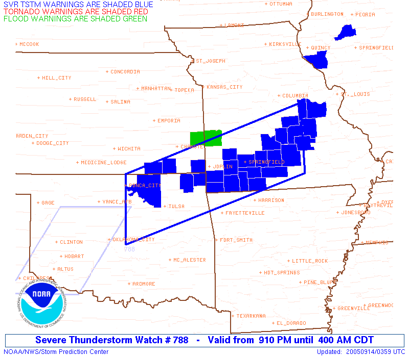
So uh.. couple warnings in Missouri right now..

ww0788_warnings.gif
 
Back
Top