6/16/06 FCST: MN / IA / WI / IL

Joined
Feb 8, 2004
Messages
1,975
Location
Detroit, MI
While the warm layer aloft may be particularly strong in some areas, the NAM paints a quite favorable synoptic environment for supercells (and possible tornadoes) -- particularly along the warm front in southern WI. Forecast soundings show a very favorable setup -- with strong boundary layer veering with height -- yielding large/curved low-level hodographs (and >150m2/s2 0-1km SRH) across southern WI. With the assumption of mid-upper 60F tds (and low 80F sfc temps) then sfc-based CAPE should increase to >3000j/kg (with SBCINH eroding by 00z) near the warm front. In addition, the favorable deep-layer kinematic profiles (i.e. deep-layer WSW flow aloft with strong speeds -- with 35-45kt 500mb flow) will poise for sufficient 0-6km deep-layer shear for sustained supercells (e.g. 35-40kts). Given the low-level convergence along the warm front -- sfc-based supercells could initiate by the mid-late afternoon in deference to regions of enhanced sfc heating/moisture pooling (locally more buoyant) to breach the capping inversion and allow for deep-layer ascent of unstable boundary layer air. Assuming 64-68 tds, then LCLs will be particularly low (<1000m AGL across southern WI per the latest NAM -- and still particularly low even when modifying the low-level moisture profiles to decrease dewpoint).

I'm sure a lot will change from now until Friday, I figured it'd be worth a thread -- especially given WI's track record :huh:
 
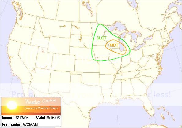
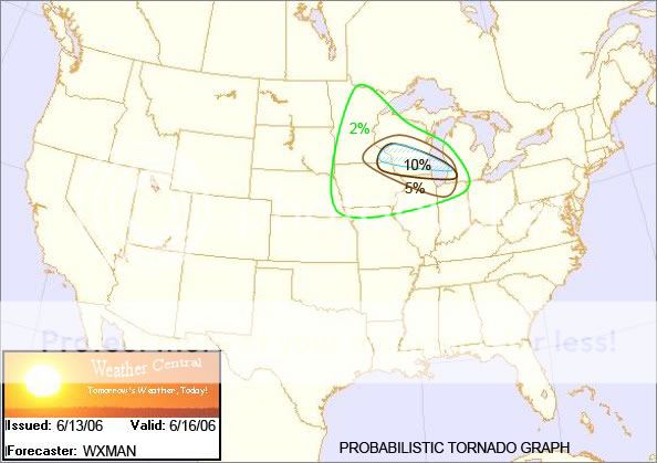
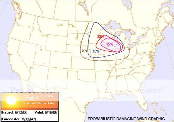
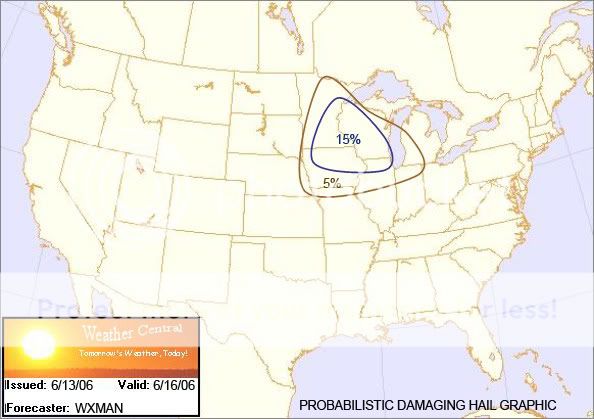
Skimmed the models, and my conclusion can best be summed up with these graphics I made:

61606.jpg


061606TOR.jpg


061606WIND.jpg


061606HAIL.jpg


Now before you flame me saying its too early to make assumptions like this, please remember, I'm familiar with this area (S WI) and its setups, and these are my interpretations of the models. So criticize fairly. :)
 
I'm a bit concerned about capping issues, seeing as MKX and the local TV mets are both downplaying the chance of thunderstorms, let alone severe/supercells on Friday. However there has been a cooling trend with the mid-level temps the last run or two, so maybe they'll come on board.
 
Actually, there is (was) a subtle convergence zone (warm frontal segment) stretching from southeast MN into southern WI -- which has since fizzled a bit in definition in the latest run. For that matter, the previous run(s) showed backed sfc flow across the region (with the earlier 12z run showing flow backed -- perhaps more due to the isallobaric forcing of the low-level flow by the elongated area of deepening low pressure to the southwest) along the warm front -- with the latest run being particularly veered (which will limit convergence). In addition, you don't get 'airmass' (pulse) thunderstorms in that kind of ambient deep-layer flow (with 30-40kt deep-layer shear across the area -- which is quite sufficient for organized deep convection), and generally an organized updraft interacting with that degree of tropospheric shear will develop rotation -- with vertical pressure gradients resulting from the interaction between the updraft and the sheared environment (which will contribute to storm intensity moreso than buoyancy -- which explains why supercells produce the largest hail out of any other convective mode. For instance, a muticellular band ingesting 5000j/kg of background CAPE will be dropping quarter-sized hail. While the established supercell upstream is ingesting 1500j/kg of CAPE and dropping baseballs).

For that matter, while the NAM is forecasting ~70 tds (and progs >3500j/kg SBCAPE as a result), I don't see why the progged LLJ couldn't advect in ~65F Tds across the area. If you even modify boundary layer dewpoints on the forecast soundings (when unmodifed show ~70F sfc tds) to the mid-60s, you'll still get ~2500j/kg SBCAPE, which could prove sufficient for organized severe weather (including supercells) given the favorable kinematic profiles.

The 00z run is less than spectacular, but there is still some potential -- and I don't see why at least a 5% risk wouldn't be introduced on SWODY3 for the area. I do, however, agree that we need a stronger forcing mechanism -- and this could prove to be the major problem for Friday.

Well I'm going to be the first one here to present a negative opinion of the severe weather event in question. The NAM is really the outlier here. In my shift Monday Night and talking with the forecaster from tonight (our local page), we both agree that any focusing mechanisms for thunderstorm activity will be to the west, may clip NW WI (we cover WI, E IA and N IL) and thus our far nw zones, but other than that we will be under a passing narrow ridge aloft. Jet stream is well away. Here's how I see things panning out...nose of strengthening LLJ with synoptic system will gradually push nne on Thursday through my area which could trigger off some thunderstorms along an advancing warm front. If anything this is the day I look for a severe weather threat with moderate to strong instability forecast, more backed surface flow than what is anticipated for Friday (sw sfc winds) and uninhibited morning heating. However LLJ will punch north and thus we will be stuck away from any real focusing mechanisms. So the only real threat of thunder I see on Friday is from air mass, pop-up thunderstorms. All of the models really dry out the column so I expect that the storm threat is rather minimal.[/b]
 
Since I am sitting, waiting for a meeting I thought I would chime in with my opinion (for the sake of good discussion of course.

In reference to the Td's, yes the NAM has been aggressively overplaying this aspect. One of the primary reasons for this as of late is that the moisture has been mixing out rather early in the chase days. I do not know much of NAM, but it seems to me that it has a problem handling the degree of mixing. With a strong LLJ overnight and really a decent one throughout the day on Friday, I would anticipate that some moisture will be in place. Perhaps a more important aspect to whether or not it will stay there is the depth of the moisture. A boundary of sorts would definitely help with some sort of pooling. It's also important to remember that with crops growing and actually covering the ground in many cases, evapotransporation will be present as well which is another reason the NAM has overestimated moisture presence in the past.

Another problem as previously noted is the backing surface winds. For those seeking a little tornado action, this will be a big problem. The main areas of cyclogenesis will be to the west and southwest of the wisconsin area. Thus, what seems to be shaping up is a broad area of southwest or SSW flow at the surface. Luckily, this shouldn't play a huge impact on your moisture availability as it would in Nebraska where I am. However, it should drastically cut down on helicity. Once again, the presence of a boundary with an easterly component to the wind will make all the difference here.

One more thing I would like to say is that perhaps this thread should include Western OK, KS, and SE Nebraska. With cyclogenesis ensuing over SW KS (998 low by 00UTC Saturday), there should be a decent easterly wind component to the North of the low. Mid level temps are higher and dewpoints lower to the west, but a strong cap may be what's needed for a decent isolated supercell chase. Whether or not supercell is the mode in western KS, OK is of question as the upper winds are not particularly spectacular. However, in SE Nebraska there is more jet support with 60+ kts at jet level, 40 kts at 500, and a good llj throughout the day.

It is a long way off, but I am excited to see how this day plays out... all the way from wisconsin to oklahoma. However, I refuse to get my hopes up because every time I do, I seem to chase towering cu to no avail. Oh well... it's the love of the chase that keeps us all going.
 
Back
Top