5/9/06 REPORTS: OK / TX

That video showed some pretty clean foundations and some really scoured ground.


Onto my report for the day..

We hung out around Holdenville for awhile filming a storm developing to our west then we dropped south to Calvin and found ourselves at a crossroad with two storms that were looking very healthy. We chose the southern option (which was about 30 minutes away) and just moments after we did the first tornado warning was issued for that storm. Talk about positive reinforcement :D

We ended up in the bad part of the storm at Coalgate (as in, nothing but rain/hail), as we were north of the rotation and then we finally pulled ahead on 43 all the while not getting much if any hail. We cleared out near Atoka Res. and we watched the storm for quite awhile in the area of the Atoka Res./Atoka/Stringtown. Observed one brief touchdown near Stringtown (E edge in the mts). That's about it, saw the same damage Shane did and actually had a wind gust of ~70mph in the town of Stringtown. We basically called it a night when things started really getting dark. Caught some lightning on the way home and that was that.
 
Ok, heres the scoop. Got 2 hrs sleep in last 30 hrs. so bear with me here. Matt Hines and myself got on storm near Claude around 7:00 or so. Got half dollar size hail 10 SW of Claude. Went up to Claude and went SE on 287. Got a wifi update in Clarendon and saw the huge supercell to the south. Took Hwy 70 south out of Clarendon and got into golfballs near Brice. Took 256 east to Lesley where we got into golfballs and some sporatic hail up to tennis balls. Wound up near Plaska where we ran out of road access and had to diverge back north and finally made it to Memphis. Took 287 SE where we got into more golfballs and tennis balls with sporatic hail up to baseballs and possibly slightly bigger. Were a few miles to the north of Childress where we heard spotter reports of SOFTBALL size hail very close to where we were. Hauled tail to Childress where we stopped at the shell station (just north of the kettle) to get gas. Got out of the truck and a wind gust of an estimated 70-80 mph occured. Ran into the station and told Matt that we needed to get gas and go NOW! He came out and at this time the wind had ceased. At that time I knew we might be in trouble. Now, I put my credit card into the pump and grabbed the gas nozzle and waited for the CC authorization. At this time I saw major power flashes just to the north of the station probably not more than 3-500 yards away. I literally dropped the gas nozzle and told Matt that we needed to go RIGHT NOW!!! As we got in the truck a very strong wind gust occured and the power on the north side of Childress went out. I KNEW RIGHT THEN A TORNADO WAS IN PROGRESS AND I KNEW AT THIS MOMENT WE WERE IN BIG TROUBLE!!! I hauled a$$ south while Matt got on the phone to call our station and the Lubbock NWS to get the tornado warning out. At this moment I was more afraid and excited than any other time in my life! We kept going south and the rest of Childress went totally dark. We got small debris hitting the truck from the very strong RFD as we neared the south end of Childress. I kept hauling at an undetermined speed :eek: 
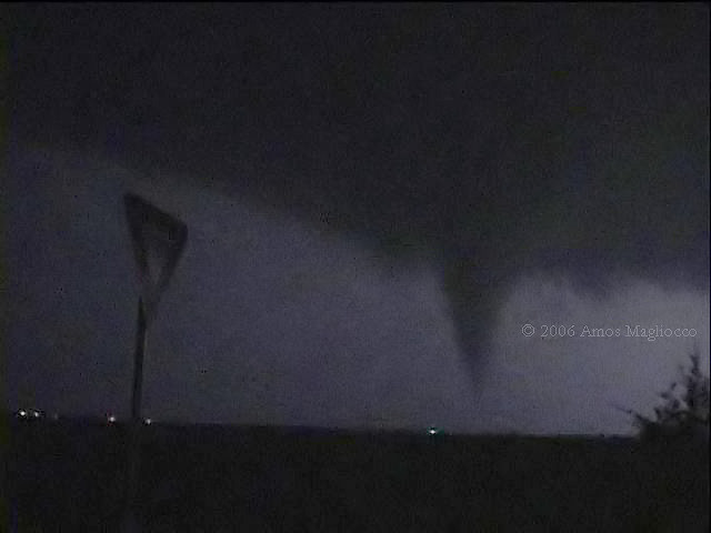
and as we got about 3 miles south of town we stopped and looked to the north and saw the tornado with power flashes continuing underneath it. No video of this tornado because we were more concerned with our own safety and the safety of the folks in town. I suppose we got about 30 sec to a minute sighting on this tornado. Look at Amos Magliocco's first photo in this thread and this is a carbon copy of what this tornado looked like. It is simply amazing how much these two resemble each other. We were chased by this thing to Vernon where we finally turned south to get out of the way. We went back to Childress to get damage footage. We stayed the night at the Best Western and got back home about 4:30 today. I will have damage video on my blog sometime tomorrow. Of 7 years of chasing, this is simply the most adrenaline filled and excited I have ever been, no questions asked. Got with the NWS in Lubbock and a preliminary survey showed probable F2 damage. 1 minor injury and 0 fatalities. Here are the photos:

LEANING POWER POLE RIGHT AT THE SHELL STATION WE WERE TRYING TO GET GAS AT (N OF THE KETTLE)
dsc048377az.jpg


GARAGE COLLAPSED ONTO VEHICLE
dsc048398ma.jpg


BIG TREE SNAPPED ON SOUTH SIDE OF TOWN MOST LIKELY BY RFD WINDS
dsc048702mp.jpg


CLOSER VIEW OF TREE
dsc048716wm.jpg


LARGE TREE DOWN NEAR THE PARK
dsc048744wu.jpg


POWER POLE DOWN NEAR PARK
dsc048773ai.jpg


WHATS LEFT OF BRIDGE IN THE PARK
dsc048804rz.jpg


ROOF AND NORTH WALL COMPLETELY GONE ON OLD HIGH SCHOOL GYM
dsc048823zz.jpg


ANOTHER VIEW OF GYM
dsc048850ih.jpg


SPC REPORT OF TORNADO IN CHILDRESS BY MYSELF AND MATT HINES (KAMR TV)
tornadoreportfromchildress5906.jpg
 
My chase tour guest Doug Steward and I were on the the tornadic supercell that hit CDS from shortly after it formed.

Here is a quote from Doug about the severe storm to our S shown in the 4th pic below: "To the south of us there was large storm developing. You can see the anvil here. Later, our storm to the west would EAT this supercell like it was an hors d'oeuvre"

We stayed just SE of the CDS supercell ending our chase day by letting the awesome beast pass to our N near Vernon.


May9_01.jpg


May9_09.jpg


May9_11.jpg


May9_10.jpg


May9_05.jpg


May9_07.jpg


May9_06.jpg


Dean Cosgrove
http://chasetours.com/
 
As a reminder...

<div class='quotetop'>QUOTE("Stormtrack Rules")</div>
(5) Chase Reports forum. In the Chase Reports forum, we allow two types of messages, as follows:
* REPORTS is for your firsthand chase report, along with photos and graphics.
* DISC is for making any non-forecasting post about an event. You may use it to make third-party reports or discuss media coverage. [/b]
--> http://www.stormtrack.org/forum/index.php?act=SR&f=19

Posting links to news organizations, or discussion that is not a report about your chase, should go in the DISC thread. REPORTS threads are intended only for chase reports and summaries. I moved a few posts out of this thread and into the DISC since they were not chase reports. Actual discussion about a chase is probably better fitted for the DISC thread, but, at this time, is allowed in here as long as you are discussing your chase report. 3rd-party pictures, discussion about storm failure and features, and other such non-report/summary items are better suited for the DISC thread. Gracias! :)
 
I Started off chasing the Tornado Warned cells in Coal County in SE Oklahoma. After a somewhat decent show, We raced back South as fast as we legally could and got to Van Alstyne in Grayson County about 10PM. I fueled up, and began to get quarter sized hail as the storm roared towards Anna, Texas. At this time the National Weather Service had issued a Tornado Warning for the storm. I pulled over South of FM455 and watched the rotation pass behind us and off to the North East. The wall cloud was absolutely beautiful, and the storm structure was amazing. As the storm approached Anna, we noticed power flashes on the ground. I reported this on the Collin County SKYWARN net, and a few lightning flashes later there was a very nice tube tornado on the ground. At my location, the wind was completely still, dry and no precipitation was falling whatsoever. This tornado grew into an elephant trunk before weakening and lifting back up into the wall cloud. Moments later the tornado dropped once again, this time in the town of Westminster, Texas. The tornado was now a very large cone tornado doing extensive F3 damage to the local communities. I will post better video captures and still images probably tomorrow, but you guys may have already seen the video on TV. I will have video on my website tomorrow as well. I have the complete chase report on my website on the 2006 documentation page as well. I do have a request. Does anyone have a screen print, or radar image from this storm at the time the tornado was on the ground? I was unable to do a print-screen of the XM while it was on the ground... It would help out a lot and I would appreciate it a ton!
~Paul
 
2006may9tor3grab12.jpg


This is a new grab of the nighttime tornado from May 9, 2006. At this point the tornado was east-northeast of Anna, Texas by about five miles and had not yet struck Westminster where it killed two people. I hadn't noticed this frame before, with the side of the tornado illuminated from lightning, and thought it was interesting because it shows the storm was higher-based than the silouhette grabs imply, and that the upper portions of the funnel were quite a bit larger than we thought. On the silouhette grabs, all of the tornado above where the collar cloud intersects the funnel *behind* the tornado is always obscured. What I mean is that we believed the tornado to be about half this size based on previous imagery, because the upper half always remained dark in backlit lightning flashes.
 
Here's an illustration of what I didn't explain very well above: first image shows what we thought the size of the funnel was approximately. You can never be sure of course, but the two-dimensional effect from backlightning made it impossible to tell the difference between the collar cloud behind the tornado and the base of the storm, so we thought a small-ish tornado from a low base:

2006may9shortgrab2adjust_filtered.jpg


This new image is taken a few minutes later, but from the orientaiton of the cloud base and position of the lights and/or trees, it's apparent that the tornado was higher-based and larger near the top than the initial grabs indicate:

2006may9tor3grab12.jpg


My report on the event is here.
 
Back
Top