5/9/06 REPORTS: OK / TX

Shane Adams

Observed a tornado-warned supercell near Lehigh, OK from birth. I lft Dallas around 3pm headed north to the Ardmore area. Mickey Ptak called and alerted me of the advancing dryline, which I had figured out myself from the cloudless skies and southwest winds. I went east in Gainseville on US82 to Sherman, then north across the river to Durant, OK. From there I moved north on OK48, with the intention of meeting Mickey and Chad near Ada, which was right along the boundary. After twenty or so miles, storms began to fire. I decided to take the cell nearest me. Because there weren't many road options and the storm was just beginning, I decided to drive east on OK7 to get ahead of it to an area withmore raod options as it developed. I drove to Atoka, then went north on OK3 to Coalgate. I had gone through town and was just about to give up on my original storm (I couldn't see much due to haze and hadn't heard any warnings) and blast north to try and get on what eventually became the McAlester storm, when a s-thunderstorm warning was finally issued. I set up north of Lehigh and waited. About two minutes after I set up a tornado warning was issued for the storm. It developed great structure, with both southeast and northeast inflow feeder bands cyclonically wrapping into the updraft region. A wall cloud developed and remained consistent for about twenty minutes, the latter half of which I was expecting a tornado, as violent vertical and rotary motions were noted. Jeff Piotrowski pulled up about halfway through all this, and kindly invited me over to his truck to have a glance at radar (my only look all day). Soon afterwards, the storm began to gust out. I raced south back to Atoka then northeast on US75, but hills, trees, and darkness forced the abandonment of that storm. As I was driving south on US75 back through Springtown, I saw a gas station overhang toppled over (from west winds as it was leaning east) and a few power poles leaned way over a few hundred yards south of there. Took US75 back south all the way to McKinney, Plano, and eventually back in Dallas. I musthave turned my NOAA radio off minutes befoe the severe storm developed behind me. In city lights and not thinking to look back north, I never even knew it was happening, as I drove right through the eventual tornado path. I walk into my hotel room feeling tired and defeated, and what do I see on television but this classic tornadic supercell right where I'd been an hour before...I had no clue that storm was forming behind me. Lesson learned...don't turn the NOAA radio off until you're home, kids.

Aside: Watched my first-ever DFW weather market real-time tornado coverage...it was worse than all the scenarios I've ever run through my head while making fun of them. Exchanges like: (anchor desk): "Hopefully those people are awake." (chief meteorlogist): [Laughs] "Well if they weren't they are now." Embarrassing. In another moment of brilliance, the cheif met went through a hugely detailed "shear marker software" display, tilting the graphic so the viewers had a "3-D" look at the storm, to "see how deep the rotation is." She then said "All I'm shoing are yellow rings, which mean more of an upper/mid-level rotation." A minute later, after reading a new NWS update on the tornado warning, she said "this storm has all the signatures of having a tornado on the ground."

There are so many more I could go into, but I need to sleep sometime tonight. Suffice to ay I'm so glad I don't live here.
 
Today looked like it was going to be interesting this morning, and it turned out to be. I'm sure it was a great day for many but not so much for me. I couldn't resist the widespread 4000+ and isolated 5000+ CAPEs. The concern for today was wind profiles, which as it seemed turned out not to be so much of an issue. Anyways left Norman probably around 3:45PM. Headed south and stopped on the south side of Norman to get a good look of the Cu to the east. Noticed an agitated area almost directly to my east at the time that was continously shooting up and finally went as I was driving east on Hwy 39. I got to Konawa and got an update over the phone as it was severe warned. We both agreed that I would have to haul butt east to intercept, and by the time I got to US 270 just west of Holdenville I decided to call it quits as these storms were moving into bad chase territory and I was/am still tired from the 700mile adventure to Dodge City yesterday. I got some great back shots of the Cu that developed into the cell which would later produce the tornado warning near/in McAlester (not sure it produced a tornado or not, perhaps reports will resolve this). Tried loading the pics a few minutes ago and for some reason any computer I tried would not detect the camera. Had to reformat the card and in the end found out it was a bad cord. Funny thing about today was as I was sitting on the south side of Norman I almost decided to go to Altus. This whole week has been good for chasing, but couldnt have been worse timing for me and probably for others (finals).
 
Just looked at the SPC reports and there's a brief touchdown logged at 7pm in Olney. I was taping constantly so I'll be reviewing video to see if I can confirm on deny this report.
 
I shot about 20 solid minutes of video right up until the time of the reported tornado (7:00pm). Jeff suggested we move south, I agreed, and then took off. He stayed. I went a mile or two then stopped again. My timestamp shows I started shooting video again at 7:03pm, which means my 3-minute gap fell in the window of the tornado report :rolleyes: . If there was a tornado, I missed it when I moved south. Par for the course today.
 
We were on the east side of a supercell near Shamrock at about the same time a larger supercell near CDS had become tornado-warned. Not a lot of structure with our storm as viewed from the ENE, but wow...what an incredible light show!

Brief OK/TX PH summary here: http://www.stormeffects.com/recent_events.htm

050909-HansfordCoTx.jpg
 
Started the day in DDC and headed to Guymon. Spent most of the day sitting there until things started happening near Boise City, then headed toward Spearman, TX. Watched a mediocre storm there try to get some surfase based action going, but it never really happened. Meanwhile the storm near Pampa really looked promising and I spent the rest of my day trying to catch it. After reaching Shamrock, I gave up on that storm and headed West on I 40 as new storms were firing near Pampa and Amarillo. Got to McLean and shot a really nice cell at about 2230. Then darted north to avoid getting pummeled. Headed back west again til I got to Jericho and shot the back side of the storm. Brian, can't agree with you more. That was an awesome light show. The pic is after the last big storm got east of me. This was taken near Jericho, TX at around 2300.
 
:D Best chase in a very long time tonight...I gotta make this short because I have finals in 5 hrs, but here we go. Left my house in Allen, around 8 and intercepted the Westminster tornado about 20 minutes later!
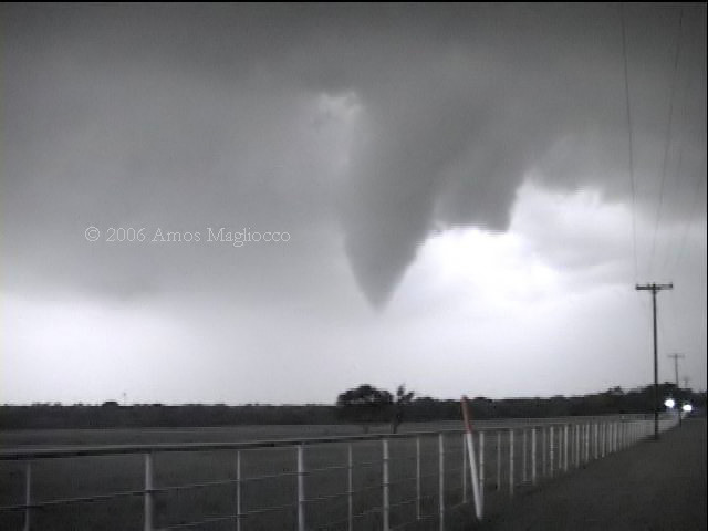
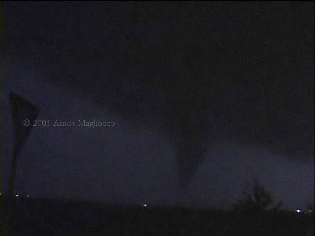
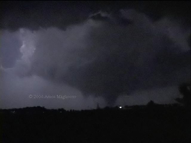
 :) It was a very nice elephant trunk tornado that grew quite large, I'd have to say almost 1/2 mile wide. It was beautifully backlit by lightning and illuminated by frequent power flashes. I observed it on the ground for almost 20 minutes. I then went to Westminster to see if I could be of any help, but there was plenty. The city from what I saw was pretty much wiped out. I would not be surprised if this tornado were and F3 or higher. I will be going out tomorrow to try and asses any damage, but for now here are some quick video captures. Oh yeah, I only used 1/4 gallon of a tank of gas! :p

5906lc.jpg


5906jc.jpg


5906ic.jpg


5906gc.jpg
 
I was on the Atoka cells as mnay others were. I did witness some amazing rotation NE of Atoka on Hwy 75 looking NE. Looking at SPC storm reports this is the same time the brief tornado was reported. I will have to look back over video but I did not see a touchdown. I did see INTENSE rotation and vertical movement however. It also looked as if a nice funnel formed very close to dark near Bruno but it was so dark and the camcorder had a hard time focusing so Ill have to look at it later. I was using my older camcorder today because the newer one is in the shop. Newer but its still about 3 years old. The older camcorder is about 5 years old but im glad I kept it as a backup. Its also nice to have two camcorders on some eventful days. One I keep on the windshield mount the other handy to just grab and shoot.
The pics of the rotation of course look mus less impressive than actualy being there. The cell in Grayson county on the way home had nice structure and backside lightning with towers lit by the moon on the way home. You could definately see the supercell shape to it.
I also finally caught the cell which impacted Childress as it made its way into Wichita Falls. Encountered golfballs briefly and again this cell had nice structure and thanks to the moon you could see it even at midnight! I was a bit concerned for Wichita Falls there for a bit but looks like the falls dodged a bullet. Some golfballs accross town but not anything too major.
I was also a bit perplexed at the severity of the cells in the Childress area etc. Not surprised there were storms but defiantely didnt think they would end up being the cells of the day basically. Just goes to show ya. Mother nature has tricks up her sleeve we will never master. Thats jsut the way it is. I think that would take part of the fun out of the hunt if we knew too much tho. :p
Hopefully we will get a nice mid afternoon good chase terrain type scenario this weekend. I am still wishing I had went out West last week more for some of those structured monsters. Cant catch em all I suppose.
I always enjoy Snyders post chase analysis. Very informative.

BTW I wont have any may chase reports up for about another week. Ill let those interested know when I get them online. http//www.texhomastormchasers.com

Chased by Jason Brock
Nowcasted by Jeff Papak
Total chase miles 436
Photo by Jason Brock
KE5HZA

Photo below of cell moving out of Wichita into Clay county Texas on U.S. HWY 287 on the way home from Atoka area.
 
Sitting here at the Kettle restaurant in Childress, TX. It's been a long night. Myself and Matt Hines witnessed a large cone tornado at about 9:25 in Childress on the north side of town. Major damage has been witnessed by myself and Matt. Since we are both with KAMR TV in Amarillo, we will be down here all night so we can be here for the morning show at 5:30. Most dramatic and scary moment in my entire life. Rest of story will come later. Damage photos will come later.
 
Thanks Dick McGowan and Matt Jacobs for the nowcasting.

Nick Grillo, Eric B'Hymer, Jordan Wrecke, and I drove a little over 800 miles yesterday. We saw a decent funnel NW of McAllister then broke south to try and intercept the storm near Atoka, OK which was an embedded piece of junk from our perspective when we intercepted it. All in all, quite a long drive for what we saw but I guess we still made the effort none the less.
 
For a storm structure photographer, I struck pay-dirt on May 9 in the southeastern TX Panhandle. I literally followed the Wayside-Lakeview-Childress monster supercell after it passed me by (it produced nickel hail on me east of Wayside in the Palu Duro Canyon)... and had a field day photographing this amazing storm from 10-20 miles to its southwest the entire evening until after it went through Childress. Two photographs follow, with more to come on my website:

_DSC2654.jpg


_DSC2687.jpg


Mike U
 
Left home around 7 PM to watch storms develop north of Dallas. Saw the tornadoes photographed by Amos.

Drove to the south end of Sherman, Texas to watch storms develop a few miles west of town. Played around the periphery of the hail cores, videoing lightning. Dropped south with thunderstorm development, to the area just north of McKinney, Texas. Then drove north to watch as tail-end-Charlie moved eastward north of Anna, Texas.

Set up on the south edge of Anna around 10:15 PM. When I first stopped, the wind was calm. A tornado had been reported as I was driving toward Anna, which I didn't see. Shortly after my arrival, I heard the warning sirens in Anna. A large round updraft base was visible over and just north of Anna in the frequent lightning, with an area of heavy rain extending just beyond the updraft base, from northwest, through north and to the northeast. Before the second tornado formed (my first), the wind picked up to 20 to 30 mph from the southeast, blowing toward the updraft base.

After a few minutes, a lowering developed on the northern side of Anna, followed within another few minutes by the development of a slender funnel, and then a tornado. This tornado lasted less than five minutes and was a slender cone in shape. Another five minutes or so passed, when a larger, fat cone shaped tornado developed ENE of Anna. This tornado expanded and moved east toward Westminster, damaging and destroying homes aong its path. So far, three fatalities and ten injuries have been reported.

Unfortunately, I left my PD150 camcorder at home, and had one with less light sensitivity. As a result, I captured no images of the tornadoes.

Participated in the Collin County SKYWARN net while watching the storm.

Got home around 1:30 AM - now, must get ready for work!

Photos are here: http://www.k5kj.net/20060509.htm
 
Ben McMillan, Kevin Sarazin and myself were also on the McAlester and Atoka storms. Although we certainly never saw ground contact, we did observe a rapidly rotating lowering/funnel about 1/3 of the way to the ground right over the Turnpike near McAlester at 658pm. This was the closest we came all day to seeing a tornado and had one occurred here it would have come down right on the highway north of us.

We then jumped on OK Hwy 43 and made the 20-mile dash through the forests to Stringtown, literally racing the southern storm to the town. Considering that we are used to chasing the cornfields and GENTLY rolling hills of IA/KS/NE it was a little bit harrowing winding through the hills catching brief glimpes of storm structure through the trees while radar is showing strong rotation moving right at us!

When we got to Stringtown at 743pm there appeared to be rapid rain-wrapped rotation just NW of town but the "mountain" prevented us from making out any details. I see that there were TOR reports from 802-804pm just ESE of Stringtown but by then we had already wandered down to Atoka. Anybody know exactly what we might have missed back there?

We sat around Atoka for quite a while to see if the SW flank of the storm would ever truly organize but it just never seemed to get its act together. About 9pm we stopped west of Atoka for several minutes along Hwy 7 to watch lightning and relax for awhile before calling it a day. Although we could see the lightning in the distance, we had no idea at the time of the magnitue of what was happening 70 miles to our south over Collin Co. TX. And of course the Childress situation was a real shocker when we heard about it on the OUN Skywarn net.

Needless to say, it was an experience chasing southeast OK and I give credit to those of you do it regularly!
Obviously it was perplexing/frustrating to see how active the western target area was, and all I can say is that its hard to completely write-off decent upslope flow out there on a day where a morning cold front doesn't completely scour out the moisture.
 
Well I am sitting in Norman still kicking myself. I was in Pauls Valley around 2:30, and had plenty of time to get some data and review approach and strategy. I figured I had a good set of options to go east when things began to fire. Instead when I saw some cells start to go just east of the OKC metro area I figured I would go NE... mistake. I should have stuck with my original plan to go east, I just jumped the gun... man I hate that. So I headed N on 177 towards Shawnee, and I saw the cells go up to my SE... the one that would be come the Coal Cnty / Atoka storm. I figured that would be the one to get on, but because of bad road options, and poor vis.... massive trees, hills, and darkness, and the fact that I had gone to far north basically took me out of the deal.

On a side note, DeLorme and / or my Earthmate was constantly giving me bad data. It showed my position further east than I actually was. At one point I had to ask some locals what roads were where. Just another excuse I guess for some bad choices that I made.

Looking on the bright side, each time I go out, even if I make mistakes, I learn a little more.
 
A storm in north central Texas produced three tornadoes last night that I observed along with Eric Nguyen and Scott Eubanks. The first tornado was four miles east of Gunter, Texas in southern Grayson County around 0210z. The second tornado was northeast of Anna by less than one mile at around 0329z and then the third, forming about five minutes later, was approximately seven miles east northeast of Anna around 0337z.

We originally targeted the intersection of the cold front and outflow boundary in central Oklahoma and spent much of the day hoping CI would occur in more chaseable terrain. When it became clear that wasn't happening, we headed home for DFW with only the slimmest idea that something would fire south of the river along the front. We were south of Gainesville when the storm went up, and, observing the dramatic signs of an explosive updraft, we turned around to chase. We weren't aware of any boundaries in the Red River Valley, but knew the dewpoints were high and expected that something around 4000 j/kg still existed in the region.

It is upsetting to read tonight that our last tornado, a wedge during its most powerful stage, killed three people in Westminster. Both myself and Sam Barricklow (K5KJ) along with a few other spotters were in constant communication with the Colin County Skywarn and NWS was aware of this tornado well before it reached the small community ten miles northeast of McKinney. However it seems possible that Westminster didn't have sirens or that this family wasn't tuned to local media or NOAA radio. Perhaps there was no shelter available. Whatever the case, I know I can speak for the other guys when I say this news negates any enthusiasm for last night's observations.

2006may9tor1grab2adjust_filtered.jpg

four miles east of Gunter in southern Grayson County, Texas ~0210z (favorable lightning strikes created the good illumination)

2006may9tor2grab1adjust_filtered.JPG

Tornado northeast of Anna, Texas by one mile ~0329z

2006may9tor3grab7adjust_filtered.JPG

Tornado approaching Westminster, Texas ~0337z. This tornado was responsible for three deaths in Westminster. The light in the foreground is not a power flash but an ambient stationary light source.

2006may9shortgrab8adjust2_filtered.jpg
 
Back
Top