5/5/06 REPORTS: TX

Joined
Jul 13, 2004
Messages
61
Location
Olathe, KS
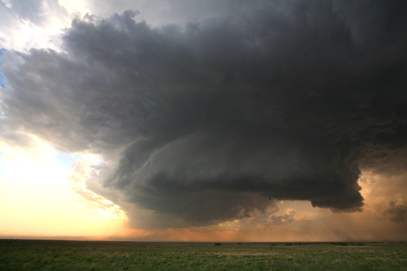
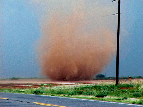
Left LBB around 5pm, heading for Seminole. Got sidetracked by the excellent visual we were getting on the storm NW of Brownfield, and cut off to head for it's base soon before the TOR warning was issued. Heard reports of tornado on the ground, but it took us a few minutes to get close enough to see it. We were viewing it from probably 1-2 miles SE, and it must have been on the old occluded meso b/c it was WAY back in the RFD. Watched it for a few minutes until it was no longer visible. At that point the storm began gusting out and went to junk. Excellent structure and strong motion, though, prior to its death.

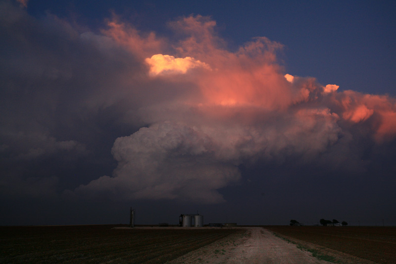
Got some timely nowcasting (thanks to Gordon May, TASC co-leader at A&M) and headed west out of Brownfield toward the Plains cell coming out of NM. About the time we got in sight of its base it went TOR warned. EXCELLENT structure with clear rain-free base, transitioning to what I've now decided is the 2nd best storm structure I've seen in my 6 year chase career (the best being the Borger/Skellytown beast late May 2002). Cell began to turn hard to the right and maintained its superb structure as it accelerated SE. We ran out of paved roads near Wellman, but it was no matter as the storm was gusting out over us. We called it a day, and made it back to LBB in time for the 10 o'clock news.

Can't wait to see what happened with the Seminole storm, we began hearing the spotter indicated TOR warnings as our Plains storm was preparing to gust out. I must say, it was nice to chase ON the Caprock, where cell coverage is good and weather radio is useful (unlike off the caprock in the rolling plains)...this is for those of us without Threatnet, of course who still rely on the ancient cell phone and HAM radio. I'll post some pics or video grabs if I have time later.

Thanks to Kirsten Orwig for nowcasting as well.


*EDIT*

Okay, here are a few crude video-grab stills:

Brownfield Storm Structure:
Brownfield%20Cell%20Structure.jpg


Brownfield Tornado:
Brownfield%20Tornado%20enhanced.jpg


Plains Cell Structure 1:
Plains%20Cell%20Structure%201.jpg


Plains Cell Structure 2 (my favorite):
Plains%20Cell%20Structure%202.jpg
 
I was driving home (from LBB to NM) today, as I have to catch a plane in ABQ in the morning, and got to Ft Sumner NM early in the afternoon. I heard lightning on the radio, so I found a WiFi hotspot, and saw from radar that there was a storm to my SW.

I started to head S on Hwy 20, but then decided I would be better off catching the dirt road S from Yeso NM. I thought 20 was going to take me too far S....too far away from the meso. Bad decision. I didn't have a serious problem navigating the dirt road, even as I drove through torrential rain as I once again neared Hwy 20, since it was pretty rocky, but I had wasted crucial time.

By the time I got back to 20, the meso was almost on me. I tried to punch it, but the hail started getting too big, and I retreated.

After awhile, I was able to get around to the back side of the storm, and I found some 1.5" hailstones.

At this point, there was no way to get into a good position without driving all the way down to Roswell, then back up toward Clovis. I was unwilling to do that. (See previous about catching plane in the AM).

I got on US285 going N. A few miles up the road, there was a pickup truck lying on its side. Hmmmm... There were several police cars there, so I didn't stop, but I sure wonder how it got into that predicament.

I was really, really angry that I hadn't just driven down 20 in the first place, where I coulda been in the right position to see.....who knows? The NOW thread mentioned possible high bases today (in NM), but it was not. Not at all. Remember, the elevation there is about 4000-5000 feet.

Bob
 
CoD caught a tornado outside Patricia, TX (SSW of Lamesa) looking SSE into the backside of the meso.

Also destroyed both windshields in the chase vans due to some nice hail earlier in the day north of Seminole.

Several gustnados and one very low based meso that was so obscured in dust we couldn't see hardly anything but it was trying sooo hard.

Video and pics are being upload right now..will post an edit when they are completed.

EDIT #1
Blog updated:
http://www.allisonhouse.com/chasing/2006/CoD/day9/

EDIT #2:
Pictures updated...another hour for video
beast.jpg

Freakishly HUGE meso that nearly touched the ground. Sucking in dirt and sand from all over the place.

tornado.jpg

Tornado outside Patricia looking SSE into the back of the meso

EDIT #3: First video is up
305Meg AVI *Warning..curse words
 
Day 1 of this years chase break, along with fellow chase partners Andrew Levine and Chris Chambers from Hawaii and Puerto Rico. A great way to start our trip!
Headed south from Pueblo late thursday, thinking LBB-Midland as a fri target. Got to Abernathy this afternoon, after driving all morning through fog and drizzle. Cleared the front and pondered whether to target cells firing on the front south of LBB, or splitting cell coming out of New Mexico via Hobbs. Decided to chase the western cell, which eventually became quite strong near Seminole. This is where we (and apparently many other chasers we saw) got our windshield taken out by tennis to baseball sized hail.
Storm got classic structure as we followed it to Patricia, where we saw the stove pipe tornado from the south (poor contrast). Ran into Dave G and Roger H and their excited crew. Absolutely gorgeous storm toward sunset with fantastic structure and color. Currently stopped in Colorado City; will have to deal with the windshiled today, hopefully in time for more fun this afternoon! :eek:
 
Left Big Spring and made it to Andrews about 3:30 or 4:00. Ran into Tony Laubach in Andrews and it was nice to finally meet him. We talked a few minutes and decided to head north towards the storms that were firing. Got to Seminole and saw a pretty good storm to the west with a nice wall cloud. I watched it for a few minutes but it weakened so I kept on heading north. Heard about the tor warned storm near Needmore and I tried to catch it but I saw the cell to the W of Brownfield and it looked really good. Saw a great meso with a wall cloud but never a tornado. Kept in front of it until it became outflow dominant south of Welch. This storm was another great catch for me today and this has probably been the best back to back 2 days of chasing ever for me even though I got a goose egg for twisters. The structure on these storms the last 2 days have just been phenominal and this is what storm chasing is all about...


WALL CLOUD WEST OF BROWNFIELD
dsc04755filtered0yr.jpg


dsc04762filtered5kz.jpg


SAME STORM WEST OF UNION
dsc04767filtered0fm.jpg


SAME STORM BECOMING VERY PHOTOGENIC WEST OF WELCH
dsc04777filtered2ap.jpg


dsc04780filtered5fx.jpg
 
Bill Reid, Brian Morganti, and myself followed a beautiful supercell from near Hobbs, NM to near Patricia, TX witnessing the beginnings of the Patricia tornado before it became rain wrapped. The structure of the storm certainly out did the the tornado (at least what we saw of it). We may have also witnessed an anti-cyclonic tornado about 4 mi south of Patricia behind the RFD in the place where you would get anti-cyclonic rotation if it were to develop. Still waiting to hear if anyone else witnessed this. Here are a few stills from today...

050506_01.jpg


http://www.tornadofx.com/temp/050506_02.jpg
http://www.tornadofx.com/temp/050506_03.jpg
http://www.tornadofx.com/temp/050506_04.jpg
http://www.tornadofx.com/temp/050506_05.jpg
http://www.tornadofx.com/temp/050506_06.jpg
http://www.tornadofx.com/temp/050506_07.jpg
 
Dean, Steve, and I staged just north of Odessa waiting for initiation. When radar showed development near Carlsbad we started north to Andrews, then west to Eunice as other cells blew up just northwest of Hobbs. As we traveled nature chose the Hobbs cell as the winner.

We end-arounded Hobbs on county roads to get to US180 east to Seminole, concerned that Hobbs would close off by any rightward storm movement. Then followed an hour or so of watch-skip east-watch just southeast of the main updraft as the storm consolidated, becoming a half-county sized vacuum cleaner. Plumes of dust consolidated from all directions underneath the rapidly rotating, scud-filled meso, eventually into a wide, opaque dust column extending from ground to cloud base. The updraft was clearly winning with ample CAPE and only 2nd class shear. Hold that thought.

We passed this same way through Seminole. Just east of the town, Wx-worx started hinting that a bit more rightward storm movement meant the routine should become watch-skip east-skip east-skip east-"what was that white thing bouncing?"-thwack-thwack-Thwack-THWACK! This driver rapidly became unconvinced that the 5+ minutes old radar gave us clear passage and his wide eyes started scanning the roadside for shelter (while his mind started contemplating how he would phrase the rental car insurance claim). Just as his eyes observed an increasingly opaque vertical ice crusher on the road ahead, a house with a little corrugated-iron carport appeared like a gift from God. Just big enough for the car and some temporary standees.

What followed was a fifteen-minute barrage that entirely covered the ground with baseballs -- yes, big baseballs.... Dean Cosgrove iced the cooler with them. While I'm easily impressed, Dean called it far-and-away the most incredible hail experience he's ever witnessed. This wasn't your mother's fall of marbles and golfballs with some baseballs thrown in. This was a tree-stripping, tin-roof torturing, deafening hard rain of mostly baseballs smashing into golfballs as they pounded any hard surface. The video is both quite spectacular and -- well -- exceedingly noisy! :lol:

Needless to say the US180 route was now infeasible and there were no south options that fit my vehicle's parameters (or common sense, IMHO). We backtracked through Seminole and then south to Andrews to re-engage the storm along SR176. While not so up-close-and-personal, the route offered a breathtaking view of the whole rotating storm updraft and rain-free base with increasingly magic side-lighting from the lowering sun. From our vantage and time period we observed no tornados in this sector of the storm. Plenty of bowl-shaped spinning meso scud, but no ground contact.

Close isn't always best, at least to us, and we stopped at an abandoned, decrepit farmhouse. It became the backdrop for an hour-long sunset show and picture-taking session (which of course I didn't have my gear completely ready to take full advantage of :rolleyes: ). Dean's time-lapse video, however, is gorgeous.

Wow! Dunno about others, but today is why I do this.... Good night from Big Spring, Texas.

P. S. Ran into Eric and Amos at Denny's. They said they were on the Seminole-Patricia storm, too, although their windshield and body panels kind of gave it away in the parking lot ;) .
 
I ran nearly 500 miles bouncing around from storm to storm across the area reporting for the station. All of those miles were run withing 50 miles of my house. I saw just about every variety of severe weather today and I am exhausted.

I can tell you one thing, this storm chasing thing is NOT VERY MUCH FUN when a supercell with an intense hook is bearing down on your home and nothing you can do about it!!!! That happened not once but TWICE today!
 
Rolled out of Lubbock on 62/82 for a white knuckle core punch on Terry Co. #1. Was still swallowing my heart back down out of my throat when I noitced an intense cell forming to my west in Yoakum Co, incredible structure and infow, but I had a date with the now warned cell in Lynn Co. Wasted my time. Raced back west on 211, south down 385 to Brownfield at which point I noticed our friend in Yoakum was making it's E-SE turn. So SE I blazed on 137 to intercept, close encounter before our fair lady blew herself away. She tried. Seriously thought my big ole' truck was going to roll for a minute. Nearby telephone pole snapped at the climax of it all.

new5jm.jpg


new36er.jpg
 
left houston at about 7am and made it to colorado city around 5. intercepted large LP north of Sentinol at 6:30 ... witnessed a new messo form and it spit out two large tornadoes... 1st one larger than the second. had to run from it when the tornado came within a 1/4 mile...


pic soon to come.
 
Great to see all the weather ethusiasts in the Permian Basin. I have never seen so many chasers on the roads down here. I followed the storm from Seminole to Patricia. Saw a brief tornado in extreme southeastern Gaines county, lasted a few minutes and was not as impressive as the tornado that was spotted a few miles SW of Patricia minutes later. Had my back to the better tornado as I was trying to reposition, had I not been flying solo probably would had got some good video of it. Big thanks goes out to Darin Brunin for nowcasting all this week.
Here are a few picts
hail_web.jpg

Pump_web.jpg
 
Back
Top