5/4/06 NOW: TX

Joined
Dec 9, 2003
Messages
4,839
Location
Oklahoma
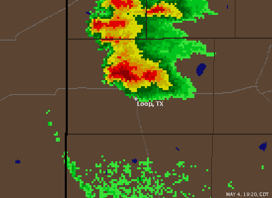
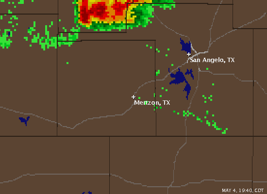
An impressive classic supercell currently located in Gaines Co (SW of LBB). Latest TVS indicates 145kts max dV, with dealiasing/unfolding issues making for a tough time on SRV1 analysis. Latest RUC mesoanalysis indicates easterly 850mb winds at 20kts beneath westerly 35kt flow at 500mb, with ~50kts deep-layer shear. Rapid turning in height near the surface is also yielding 300-350 0-3km SRH. Instability isn't notably strong, but obviously sufficient. There was another nice supercell or two east of SJT earlier this evening, and a new storm nw of SJT has midlevel rotation as well. Ah, the power of stronger deeplayer shear... The last few days has seen 30-35kts deeplayer shear (for the most part!), and I think the stronger deeplayer shear is helping keep this cell more on the classic-HP side, rather than full HP side.

Current radar image indicates the hook is right over the town of Seminole right now... The cell N of that cell (along the Yoakum/Gaines Co. line) is also beginning to show rotation on the lower SRV tilts, with a strong reflectivity gradient an hints of the upshear side of the storm starting to wrap around the meso.

Latest SVR from the Midland NWSFO indicating that spotters are reporting a persistent funnel just west of Seminole.
 
0z MAF sounding shows a nice hodograph, with >100 m2/s2 0-1km SRH and 50kts 0-6km shear. 2500 j/kg CAPE too... pretty nice vertical wind profile...

Anyone know who's chasing the cell nw of SJT? Getting close to grapefruit size...
<div class='quotetop'>QUOTE("SJT LSR")</div>
0755 PM HAIL 17 WNW ARDEN 31.56N 101.02W
05/04/2006 M4.00 INCH TOM GREEN TX STORM CHASER [/b]
 
Also a very nice couplet on the storm moving out of Mason into Llano county. Looks like about 80 kt of g2g shear with that one. Things could get interesting now that LCL's are lowering, and winds continue to back more and more.
 
The hook / meso on the Gaines co. cell looks like it's cutting away from the main reflectivity core... The meso looks to be moving SE, and a blob of reflectivity is moving along with it, almost detaching from the main core. The latest scan continues to show this area moving away from / detaching from the rest of the core... Very interesting! Never seen this type of structure/transition...
 
The hook / meso on the Gaines co. cell looks like it's cutting away from the main reflectivity core... The meso looks to be moving SE, and a blob of reflectivity is moving along with it, almost detaching from the main core. The latest scan continues to show this area moving away from / detaching from the rest of the core... Very interesting! Never seen this type of structure/transition...
[/b]

Just to provide a radar grab of the feature Jeff is describing. Very interesting indeed!
060504loop.gif


And Mertzon and areas just to the west of there are about to get whaled by the business end of the tornadic supercell in eastern Irion County.

060504mertz.gif
 
The Irion co cell appears to be sustaining itself on strong convergence along the residual OFB southwest of SJT. Reflectivity structure looks impressive, but velocities imagery from SJT isn't showing a whole lot... There have been several reports of 4.25" hail over the past 30 minutes in Mertzon, sw of SJT. This is the same cell that produced 4" hail earlier. I can't help but think that if people are reporting 4.25" hail that there aren't even larger hailstones around (in the fields, etc). Regardless, very strong low-level shear and enhanced baroclinic vorticity along that OFB seem to be supporting this significant supercell and aiding in the massive hail growth.
 
I've actually seen that structure numerous times during my thesis work. Usually its connected to the main core by the way of an arch of reflectivity. Many times, these qualify as DRCs. Don't expect me to explain the process, however. We're still working on that. Only so much we can do with single Doppler data...

In this case, it almost looks like a new convective cell that developed (right split). In other cases, the protuberance is connected to the overhang of the storm and does not appear to be a seperate cell. It actaully looks like this later on...

Aaron
 
Back
Top