5/31/06 REPORTS: CO / KS

Joined
Mar 19, 2005
Messages
558
Location
Independence, MO
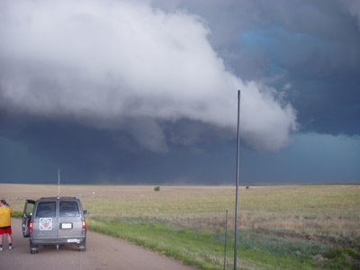
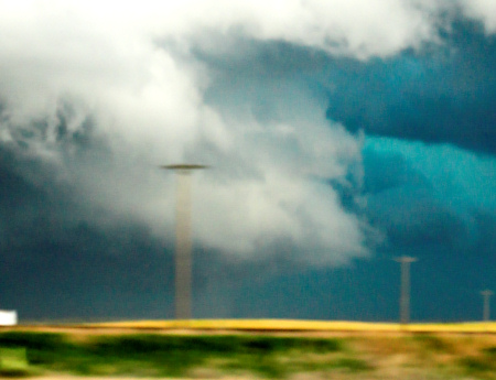
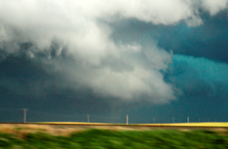
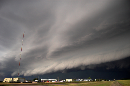
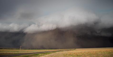
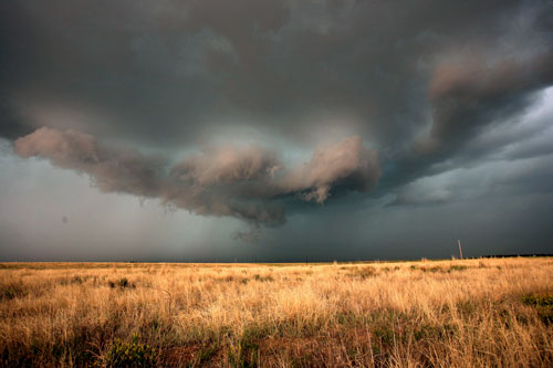
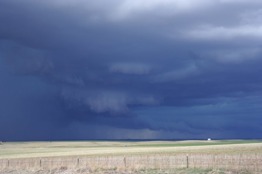
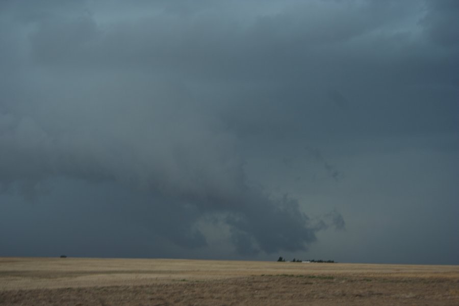
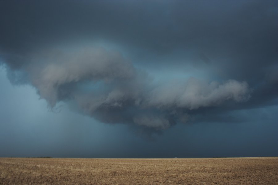
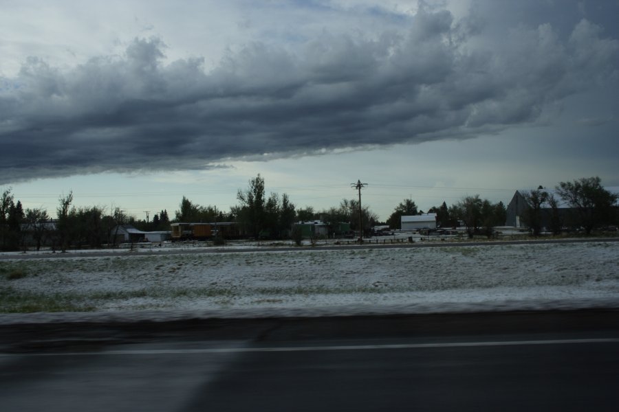
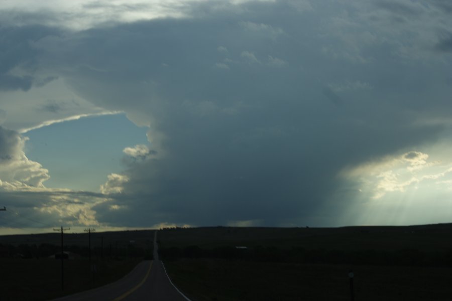
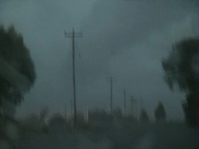
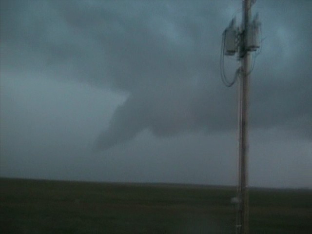
It was a pretty ho hum day around my farm until about 3:00 p.m. In the northwest I noticed a dark thunderhead building and went ahead and consulted the NWS radar. A fairly strong storm was moving off the Cheyenne Ridge and a few minutes later went SVR warned for quarter size hail. As it moved southeast, it began to exhibit signs of rotation both visually and on the base velocity. So at 3:40 p.m. I headed northwest and criscrossed back roads to a hill about 4 miles southwest of the locale of Buckingham. I arrived at 3:50 p.m. and watched for the next ten minutes as an impressive wall cloud got its act together and began to rotate furiously. Just before 4:00 p.m. I noticed a slightly wrain wrapped condensation funnel lowering towards the ground from the wall cloud and dust being sucked upwards toward the lowering. Eventually it made contact with the ground shortly before becoming rain wrapped, and I called it in to the NWS before I hightailed south and east to avoid the now massive monster HP supercell.Two minutes after I arrived at my farm, put the truck in the garage and raced into the house, the storm struck. For ten minutes pea to nickel size hail and heavy rain fell almost horizontally out of the north, blown by 70 mph winds. The storm finally cleared out about 45 minutes later, but not before dumping 1 1/2 inches of much needed and welcome rain. The tornado wasn't all that big and was fairly short lived but it still was a tornado! I have a picture of the tornado which I will attempt to post at a later time. A great backyard chase on what appeared at best to be a moderate severe day. :D
 
Ron Gravelle, Scott Keddie and I left Amarillo this morning, and headed north. We intercepted a large haboob in eastern CO (southeast of Limon) into western KS. We saw a beautiful large shelf cloud, a couple wall clouds, and tons of dust.

We didn't get any tornadoes but the storm structure sure as heck made up for that. The colors were amazing, with the yellowish fields, green/blueish core, and white/gray clouds. We are staying in Oakley, KS overnight.

I really wish I could upload a picture because words just don't describe this experience. That will have to wait when I get back home next weekend.

Edited: I added a couple images

20060531_haboobwallcloud1.jpg


20060531_haboobwallcloud2.jpg
 
Ron Gravelle, Scott Keddie and I left Armarillo this morning, and headed north. We intercepted a large haboob in eastern CO (southeast of Limon) into western KS. We saw a beautiful large shelf cloud, a couple wall clouds, and tons of dust.

We didn't get any tornadoes but the storm structure sure as heck made up for that. The colors were amazing, with the yellowish fields, green/blueish core, and white/gray clouds. We are staying in Oakley, KS overnight.

I really wish I could upload a picture because words just don't describe this experience. That will have to wait when I get back home next weekend.
[/b]

Laura,

Since I think this was your van in the shot.... Here is one for ya...
P1010018.1.jpg


We left Elk City, OK at about 9AM this morning and headed through Amarillo with an initial target of Lamar, CO.

Made it to Lamar about 2:45 Mountain Time and head West a bit..... It became apparent that the cluster of storms on the New Mexico/Colorado Border was eating into any chance for the intial target area of Lamar to La Junta, CO to work out.

So we booked north about 90 miles to the cell to the SE of Limon, CO.

When we got there we were just in time for a pretty shot or two

P1010014.0.jpg


Ended up going South at Wallace, KS and not being able to outrun the rain.... it got pretty hairy for a while on a dirt road.... but made it out alive and in Garden City, KS for the night......
 
Wow, what an action-packed chase day yesterday (5/31)! Jay, Jon, Rob, Mitch, and I left Clayton, NM by 11:30am or so and headed north through Lamar to Limon. We arrived in Limon as a supercell was underway to our northwest. The storm was still in an organizing state to our northwest. We drove north of Limon to photograph some of the high based structure that had a meso embedded in it to our west.

We followed this storm as it cycled through stages of organization north of I-70…then along the I-70 corridor from Bovina to Flagler, CO. By the time we approached Flager, our storms were becoming a mess. There was an isolated supercell to the northwest near Fort Morgan which I was tempted to intercept since at the time it was the best looking thing around. It turned out this was a good idea NOT to chase… as our original activity was about to undergo some significant changes for the better. We drove through the core of a cell to our immediate east and south that had some dime size hail.

At Burlington, we optioned south just to get into some clear air so we could “breathe†a little easier with respect to staying ahead of all this stuff. As we went south on US-385 we eventually got far enough south to see some impressive mid level structure with the one cell to our immediate west that had a little meso with it. This whole area from southeast of Burlington down south to west of Cheyenne Wells, CO was exploding into an impressive HP beast churning up a ton of dust with small scale vortices (gustnadoes) along the gust front. The gust front wasn’t really surging east that far from the developing updrafts… therefore some of the gustnadoes almost appeared as if they were hybrid front-flank weak tornadoes.

There was really interesting cloud base rotation at various portions along this inflow/outflow interface where the new updrafts were going up vigorously. At these locally enhanced areas of rotation, the dust would organize in a column and rise up to meet the cloud base rotation. Really, really interesting!

We actually took a dusty farm road east through all this stuff… north of Hwy 40 between Cheyenne Wells and Arapahoe. At various points along this adventurous dusty drive, the visibility went to ZERO in dust with northwest winds around 40 to 55 mph or so. Jon and Mitch were shooting video during all of this and I’m looking forward to seeing how that turned out.

We got back to US-40 and blasted east to Weskan, KS. Near Weskan, we looked off to the north into the notch of this HP beast. There was an impressive column of dust that looked better than any other dust column we had seen and it was right where radar was indicating strong shear. It’s possible we were looking at a weak tornadic circulation back in the notch. I was able to get a couple photos of this while we were driving east, but it’s fairly inconclusive as to whether this was really a tornado or just a well developed gustnado. Probably a hybrid?

_DSC3757.jpg


_DSC3758.jpg


Eventually, this whole thing became one giant dust storm at the leading edge with haboob characteristics at the front edge. When we got on the east side of Sharon Springs as this monster storm approached Sharon Springs… the structure was magnificent! It was just a huge wall of updraft right above the dust wall/haboob. Wow! I was fortunate enough to capture all of this on the digital SLR. It was an awesome sight! We finally aborted the chase northeast of Wallace and backtracked through the storm back to Goodland where we stayed for the night.

_DSC3792.jpg


_DSC3836.jpg
 
Joe Spencer and I left Borger, TX from the previous days chase and were targetting somewhere between Lamar and Kit Carson, CO. Got to Lamar and read the MD about the boundary up near I-70 and with the TOR warning in Arapahoe County headed north to Kit Carson and then to Seibert to avoid the construction on 287. Got to I-70 and headed to Limon and topped off the tanks and then headed back to Genoa and waited there for the storm. Basically played cat and mouse with it until Seibert and then headed back south toward Kit Carson again. Sat about 8 mi North of there for about 20-30 min and debated about calling it a day as things looked rather dull at this point............storms were firing up along the boundary and nothing really looked appetizing. Decided it was too early to give up and headed to Kit Carson and then east on Hwy 40 toward Cheyenne Wells. Got really interesting there as we were coming into Cheyenne Wells. Punching thru the core we got blasted by high winds and heavy rain. After we could see the leaded edge there were numerous circulations on it, as Mike saw as well, not really sure what to make out of that either, but it was interesting watching a couple of them tighten up pretty good. Finally got out ahead of the storm near Sharon Springs and stopped just W of Wallace to film it. Should be some really great time lapse video from this one. Considering the way this season has been going, this was really a fun chase!! Even if it were a banner year for me, this was still a fun chase!! Got some great lightning pics heading back to Denver as well.


Breaking out ahead of the storm near Sharon Springs.


Its approach near Wallace, KS


CG near Aroya, CO


Stopped again near Hugo, CO for another pop up storm


Webpage updated here

http://coloradostormchaser.com/31may06eco.htm
 
Michael and I jumped on the Limon, CO storm and had a great view from above Cedar Point, followed it out I-70. Saw many times where it tried to spin something up but no real tornadoes. A very fun chase!

20060531_40_sm.jpg

Funnel appearing out of the rain as it was Tornado warned in Arapahoe County.

20060531_12_sm.jpg

Meso lifts over Cedar Point hill as the terrain increase seems to lower the lcls for a bit.

20060531_15_sm.jpg

Another funnel tries to spin up over Cedar Point.

20060531_28_sm.jpg

Another funnel trying to form north of Flagler, CO - good lift but no spin
 
Another shot of the funnel north of Flagler - from the N edge of town. Didn't get any stills, so this is a video capture:

[attachmentid=354]

A few minutes later, racing east on 70 near Arriba, this was out my right hand window.

[attachmentid=355]

And a bit later...hail in Goodland...complete with snowplows working the highway!
 
I also initially targeted the LaJunta-Lamar axis when approaching from Vega TX, but since I couldn't get data at my motel in the morning (lightning had knocked out internet and cable TV service for all of Vega, apparently), I stopped at the library in Springfield. I still liked my initial target, but with convection already occurring on the NM/CO state line, I decided that I might have to just wait for that to migrate toward my target.

I started driving toward Trinidad, then headed S on the dirt roads toward OK.

When I was almost in OK, there were two mesos, and the SW one dropped what may or may not have been a tornado (in NM):


(click to view larger versions)

At the time, the inflow scud was dancing around the wall cloud quite vigorously, then that "feature" lowered to below my line of site with a completely different "look of authority" to it than the scud had had, and persisted for a couple minutes. I took the pic with the camera zoomed all the way in, and the haze, etc., made the "tornado" almost impossible to see in the pic until I used every editing tool I have to get it to what you see here.

The updrafts stopped with those mesos, so I headed for the haboob, punched it, then caught these pics just outside Limon at sunset:


P.S. If anyone has nothing better to do and would like to try messing around with editing the original "tornado" picture yourself, give me a PM and I'll send ya the original. I used Picassa2, ZoomBrowser, Paint, and Neat Image.
 
We left Amarillo and checked data at Lamar. We met up with Sam and Al north of Lamar ona side road and got to the storm as it approached Limon. It was already in a HP state there though we did get a look at the rotating base. The storm became outflow dominant so we headed for the small cells near Colorado Springs in case an LP spun up. We got drfits of small hail due to high elevation and slow moving cell. It was quite pretty to have hail and reflection of lightning. I did not know that the terrain there got as high as 2300 metres which is higher than Australia's highest mountain.

Supercell near Limon

0531jd08.jpg


0531jd13.jpg


0531jd23.jpg


0531jd31.jpg


East of Limon

0531jd26.jpg


Hail had covered the road from the supercell earlier near Limon which was cleared prior to our westward progress:

0531jd40.jpg


Some cells that went severe later in the day near Colroado Springs:


0531jd46.jpg


These are the cells that became almost staionary and dumped copious amounts of hail in short periods in very high elevation.

Jimmy Deguara
 
Storm Chase May 31 with Images

Today was a marginal day but there was still possibility of storms in the eastern Colorado, and northeastern New Mexico. Jason and I started in Amarillo, TX. After a steak breakfast at the Big Texan, we were about to leave when we heard a faint mewing. It was cold, windy and rainy and the mewing faded with gusts of wind. We looked around and found a kitten hiding behind the front wheel of Jason's car. It was shaking and had singed whiskers. The cat was obviously very cold and scared and was only a few months old. It may have been near the engine which caused the singed whiskers. We stopped by Walmart for some cat supplies including a carrier. Luckily for the cat, Jason and his wife do cat rescue. Jason named her "meso."

After the cat was prepared with a carrier, some food, water and litter, we headed north to Boise City OK and met up with Charles Edwards of Cloud 9 Tours. Storms were already firing in Colorado. There was persistent development around Trinidad with some smaller storms to the southeast. We headed west on 160, initially targeting the storm moving east from Trinidad. Unfortunately, it became more outflow dominant. By then, one of several storms in northeastern New Mexico was becoming stronger. We dropped south on 389 through the town of Branson. Near the Capulin Volcano, we encountered minor flooding and hail. We headed southeast on 64 toward Clayton, New Mexico. The storm, now to our north, was all outflow. There was no chance of tornadic development. The scenery was still pretty and Jason and I stopped to photograph the gustfront. Charles and his group stopped in Clayton for the evening. Jason and I followed the storm northeast along 412 back to Boise City, Oklahoma. There was some pretty lightning but nothing special. At one point, there was a suspicious lowering but as we got closer, it was obviously scud and outflow features. Jason decided to stay in Guymon before heading home. I checked some data in Guymon and decided three was not a decent possibility of tornadic development for the remainder of my vacation. I decided to drive back to Oklahoma City that night and I was a able to catch a flight back to Virginia the next day. Thus, my chase vacation ends early. There's always next year.

IMAGES

Jason Persoff and I at the Big Texan eating steak for breakfast
http://www.harkphoto.com/053106bigtexan.jpg

Jason finds a new friend under the wheel well
http://www.harkphoto.com/053106jasonmeso.jpg

Close up of "Meso" the kitten. That is one lucky cat considering Jason and his wife do cat rescue.
http://www.harkphoto.com/053106meso.jpg

Charles Edwards and the Cloud 9 tourists prepare to watch the storm
http://www.harkphoto.com/053106cloud9.jpg

Close up of Charles Edwards filming the storm. He is the owner of Cloud 9 Tours.
http://www.harkphoto.com/053106charlesedwards.jpg

Outflow dominated storm in southeastern Colorado
http://www.harkphoto.com/053106storm.jpg

Second storm in northeastern New Mexico.
http://www.harkphoto.com/053106outflow.jpg

Suspicious lowering northeast of Clayton, NM that was just scud.
http://www.harkphoto.com/053106lowering.jpg
 
Yeah...I loved this day. I saw the storm building on radar, and i took off east on 70. I came into the back side of the downdraft and started getting some heavy rains. The rain was beating down, and soon turned to hail. I kept going on east, and trying to get through the hail core i was in. The hail was starting to accumulate about 2 or 3 inches on the roadway. Cars were pulled over, and there were some trees being broken down by some serious winds. I didnt have a radar, or a radio so i had no idea of any warnings, but it was obviously severe with some quarter hail that broke off the windshield wipers, and plastic vent-shades. We were hydroplaning on hail at about 35 mph, so it was a struggle to get ahead of the storm, which was probably moving at around the same rate. Eventually we got under the shelf cloud, just ahead of the main core, and fought east to get into the updraft. This is my second year of chasing, and the first time i really saw such a large amount of chasers around. They seemed to be everywhere. One of the sweetest things i saw was some serious looking action being scanned by the doppler on wheels. That was the first time i ever saw the DOW, and it was scanning the storm...I figured it was on the cusp of making a tornado, it sure looked like it. We got some unbelievable shots, and went east to outrun the downdraft again. The whole thing was really twisted looking, and had some obvious rotation in it, even though it was a large line. We made it to flagler, and i got to look at the mobile threat net in a chase tour van.. The guy was cool, and showed me the doppler, and we gassed up and i went north down some dirt road, and saw what looked to me like a tornado trying to form. When i get the stuff uploaded, you should take a look at the shots of this thing and tell me what it is, because i know it was a big line storm, and really didnt have the the i guess...dynamics of making a tornado. But, there was a big funnel shaped cloud just a few hundred feet off the ground! Its the same one Verne Carlson has, but i saw it from a different view, earlier than his i think. The thing was, it wasnt rotating too well...
z43181406.jpg

z43181354.jpg

b43180068.jpg

We got blasted a few more times by the winds hoping they would blow away some sheds we found farther east. They didnt, but that day was the brass ring of my 2006 chase year.
 
Back
Top