5/29/06 REPORTS: MN / IA / NE / KS / OK / TX

Joined
May 18, 2004
Messages
285
Location
Centennial, CO
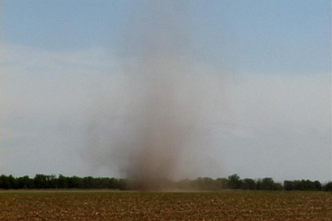
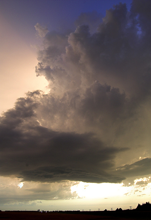
Bill Hark and I witnessed tandem vortices today that were fairly spectacular and appear to have caused less than F0 damage. Because...they were dust devils. But they were beautiful specimens in fact: each easily extended over 1000 ft in the air as huge (but thin) rotating columns. They were--in both of our opinions--the tallest and best-developed dust devils either of us have ever witnessed and were totally unexpected.

They formed off of Hwy 81 in Polk Cty just north of Stromsburg around 3pm (roughly, I'll have to look at the video time stamp). They were long-lived, though, sadly, not long-enough lived to allow me to take stills. I will try to edit the vidcaps tonight and post 'em here. As with tornadoes, these vortices continued to exist even though their debris cloud at the sfc dissipated: faint higher level dust continued to show their existence as they passed over much greener terrain.

A veritable outbreak of dust devils continued, but none as spectacular as those two. So cool were these that Bill's video is to appear on the Weather Channel tonight. Very cool anomoly in what otherwise was at best a travel day :).

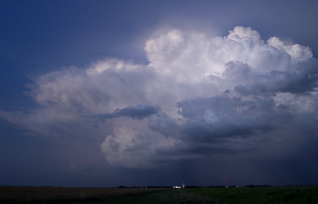
This attachment was MARKEDLY altered in order to highlight the structure of the dust devil. With everything maxed (particularly contrast), you can get an idea of the height of the column. Ironically, maxing everything out also had the added benefit of making it look a bit like a tornado, but this is a video grab of the dust devil).
[attachmentid=338]
 
See Jason's description and report above. Here is a video still and I may add more later.


dustdevil1.jpg


Bill Hark
(Where are the real tornadoes???)
 
060529011.jpg


Central MN:
Started out in HCD waiting for the cu field to thicken up. Noticed
lapse rates were steeper to the north of my so drifted up 15 to Kimbal
and watched as turkey towers started to form. Drifted north some more
to STC where a very noticeable tower was starting to form in the very
NW corner of Stearns county. Continued up 10 to LXL where a sharper
base started to form under a half way decently sheared updraft.
Followed this up to BRD where it formed a nice persistent wall cloud
for about 20 minutes until the precip wrapped in. Followed it east on
CR18 until it become totally obscured at highy 210. Tried to get
south to the next storm but got caught up in small hail and holiday
traffic so called it a day after uploading media to Fox9.

http://mnwxchaser.com/06may29.html
 
I expected today to be extremely marginal and the only reason I chased was to get in better position for severe weather expected on Tuesday. There was a front across Kansas with southeasterly winds. Upper level winds were quite low and I expected low grade severe storms. I was chasing with Jason Persoff. We headed south from Mitchell South Dakota (home of the corn palace) under clear skies and a brisk northwesterly wind. We crossed into Nebraska enjoying beautiful scenery especially near Niobrara. There is a crossing of the Missouri River with low hills and marshes. We followed 14 south, picked up 81. Just north of Stromsburg in the early afternoon, we sighted two very large and tall dust devils. More were visible in the distance. We briefly chased them and obtained some nice video. Soon we crossed the front and temps rose into the low 90’s. When we crossed into Kansas, we noticed some cumulus with vertical development. There was a nice cumulus field visible on satellite near Salina. Farther south by a mesolow, storms were already developing near Medicine Lodge. In Salina, checked data and noticed a bullseye of CAPE with backed winds, and higher helicities. We couldn’t reach the storms near Medicine Lodge. Salina was a good place to wait and watch the developing cumulus. Several showers formed and dissipated. Interestingly, we noticed a boundary approaching from the east on the SPC mesoanalysis page. By evening, a new storm exploded just to the northeast of Salina. We headed west, then north on a dirt road to get a better view. At the top of a hill we were treated to an awesome sight with an orange sky surrounding a developing storm. There were two main cores. The southern one became more defined with inflow bands and evidence of rotation. There was even a ragged wall cloud though it is unclear if there was rotation. We followed the storm north for awhile until it became too dark. Now I am Salina checking data for a possible chase into the Oklahoma Panhandle or possible northern Texas Panhandle. This is much more traditional chase territory.

Dust devil

http://www.harkphoto.com/052906dustdevil.jpg

Dust devil closeup

http://www.harkphoto.com/052906dustdevilclose.jpg

Dust devil contrast enhanced

http://www.harkphoto.com/052906dustdevilenhanced.jpg

Approaching severe storm

http://www.harkphoto.com/052906stormapproach

View of storm

http://www.harkphoto.com/052906storm

Storm becoming supercellular

http://www.harkphoto.com/052906stormwide

Ragged wall cloud

http://www.harkphoto.com/052906raggedwall

Another lowering
http://www.harkphoto.com/052906lowering

052906stormwide.jpg


Bill Hark
 
I suffered a similar vehicle fate as Dan Robinson, but fortunately there were a list of upsides to my pending disaster. While getting off I-470 to the Turnpike, my van suddenly and casually refused to move into third gear. It would keep reving. I called Verne on the radio and informed him I was having vehicle issues and we stopped off on the side of the road. The van wouldn't get into third gear. I could move throughout drive, neutral, and reverse with no problems, but when it got to third, it would suddenly rev up very high, then drop into gear hard. Obviously I elected to find the closest shop I could find. Unfortunately, it was Memorial Day, so nothing was opened. We found a transmission shop right off the highway, so I unpacked the van, loaded it into Verne's car, and left the van behind at the shop who I'll call first thing in the morning to inform them of my situation. In the meantime, I'll chase the next couple days with Verne and Michael in the Suparu and hopefully by Thursday, can return to Topeka to claim my van and pending repair costs and future setups, will likely head home Friday and begin the close-to-home setups to wrap up the final week of Mayathon.

After piling into the car, we continued to our destination and watched storms go up along the front down south at first, then one began to form over Pratt which was directly in line with us. We were about an hour out as it began to intensify and slowly move north/northeast. We arrived near Cunningham and moved north to get a better view of the base of the storm, then elected to drop back onto the highway and sit in Cunningham in a lame attempt to get cored. The storm fizzled quick, and we left it be continuing west to Pratt for dinner and to Liberal for the night.

The biggest photos of the day came at sunset in Pratt; here are a couple shots...

060529a.jpg


060529b.jpg
 
I dropped my wallet on the side of the road while watching clouds near Burlington, OK... didn't realize it until I was calling it a night in Enid...... Bummer... had to backtrack 1.5 hours...,and amazingly found it..... and ended up in Woodward, OK for tomorrows fun...
 
Targeted Cent S Kansas/NW/N Oklahoma today. Drove all the way from Lincoln, Nebraska. As we were heading south-west from Hutchinson, Kansas, we noticed a cell pop up on the Baron system, near Woodward, Oklahoma. We carried on towards Medicine Lodge, Kansas. When we got there, the south-western sky was black. We headed south and then west...got some good video of the strong outflow from the storms as we briefly went under the gust front...we managed to get out of it again, and keep ahead of the storms. They were very outflow dominant, which meant no chance for tornadoes. However, we were expecting them to be this kind of storm, so weren't expecting tornadoes! Plenty of dust was being lifted by the outflow, which extended some 15 miles ahead of the storms. As evening fell, we were treated to spectacular lightning, although by now the storms had torrential rain in them, which precluded any photography.


We beat our way south through the expanding mass of storms, and arrived at the Sleep Inn, in Edmond, Oklahoma around midnight. It was very warm and humid, but within 5 minutes of our arrival, the gust front from the storms to our north moved in, blowing everything around. However, the storms remained to the north.

A few pics here
 
Jay, Stacie, and I left Lawrence around 1pm and headed for a target area around the Hutchinson-Newton vicinity. We met back up with Rob, Mitch, and Jon in South Hutchinson at a roadside historical marker at the intersection of Hwy 96 and 50… where we awaited convective development in our target area for quite awhile. A large multicell complex of storms had developed well to our south near Alva, OK which was about 80 miles from us. We decided to forego this in hopes of development closer to our west.

After becoming increasingly impatient, we decided to drop south as the towering Cu to our immediate west and northwest just weren’t doing much. We intercepted a small complex of three storms in northeastern Pratt County, two of which were right-left split members that broke off before we got to the area. The left split which was moving just west of due north…was the healthiest of the three. We headed north through Langdon after we drove south about 20 miles…then back west. The storms just weren’t all that photogenic as observed from the east. We decided to get west of the storms and shoot the backside of them as sunset approached.

The left split soon died, but we were rewarded from our decision to move west…as the sky from north through east through south was very photogenic with beautiful mammatus and a golden wheat foreground. This is why I love Kansas! I had a very unique sunlight ray phenomenon that lit up the eastern horizon in a vertical triangular column. It was extremely impressive and I was fortunate enough to capture this with nice foreground.

After hanging around here along Hwy 50 in Stafford County, we decided to continue west back to Dodge City. A new storm was developing just west of us which began to take on beautiful colored structure. The colors were just incredible! I couldn’t believe it.

We stopped again to photograph this little storm… then headed west some more before stopping one more time to photograph the Cumulonimbus looking back to the east after sunset as these new storms were becoming better organized.

_DSC3456.jpg


_DSC3506.jpg


_DSC3521.jpg
 
Well this was an interesting day close to home for once. There was a cold front just east of town into IA that I targetted around 2 pm. I drove east and wound up meeting up with Bob Matzen from Blair north of Harlan IA. We watched the towers on this boundary for quite a long time. It was fun to at least be able to crack jokes about the day. We gave up on it about 4 hours later than we should have and headed home around 6:30. I've never seen storms so close for so long. The biggest problem was that area of convection in ne KS early in the day, morning actually. The cirrus from that stuff kept the cold front in check for quite a while. I loaded a satellite loop in Harlan before I went home and you could see how bad it really was. The windshift line on the east side of the cirrus canopy was interesting. Anyway, headed home disgusted from having a bust 3 days in a row, or so I thought.

I went out to run the dogs around 9 and noticed the lightning to the south. I came back home for a while waiting on the convection to increase or move north. It was on the cold front finally. There was even a tornado warning just into KS. It increases and I head towards the east side of Omaha. I thought about getting the skyline and lightning from the casinos in IA but turned around figuring I'd just be dealing with anvill precip. I headed back west and to the sw side of Omaha. I get off at the Gretna exit and find a little gravel road that would work. Well the second I stop the sprinkles start. Ug. I then head west into Gretna and top off the tank. I then headed north to get out of the sprinkles. I stop at a new development between Elkhorn and Gretna. I drove around it and everywhere seemed to be just too low. Getting more and more frustrated I just about went home. The lightning hadn't been too crazy yet anyway, the sprinkles were pissing me off, and not being able to find a spot that works and is free of people wondering what you are doing were all adding up. Oh yeah and it was getting late after an already frustrating day and certainly last several days. Then I find it! A spot without a house and up high.

I set up the camera and soon learn I would really wish I had my lens hood with. The couple of lights off to the left were causing flares on the images. So I had to sit there and hold either my hand or the bill of my hat just out of the picture and to the left of the lens. It was very annoying to do for as long as I did it but it was doing the job. I think I sat in this spot shooting these for a solid 2 hours. What a treat to be just outside of the sprinkles, at a high location free of any traffic(not one car ever came up to this spot) and have an intense area of convection just sitting there in on spot. Some of the anvil crawlers were rather amazing to watch. You'd get a big hit off on the horizon somewhere closer to the rain and then they would zoom for miles overhead. I do have some others but these are the better ones. I might add a couple others later today.

06-5-29-6358.jpg


06-5-29-6366.jpg


06-5-29-6371.jpg


06-5-29-6372.jpg


http://www.extremeinstability.com/06-5-29.htm
Pretty much the same ones are on there right now, but I plan to add a couple others.
 
Intercepted developing storms near Austin, MN. The chase was about what I expected with mostly linear storms that exhibited the consquence of horrible mid-level flow. Intial severe warned cell produced 45-50kt winds and at least had a shelf. Chased several more storms as they moved NE and for most of the time they lacked significant visibile structure. There was at least one brief lowering but it lacked any rotation and gave way particularly fast. Cloud bases also seemed a little higher than the expected 1200-1400m.

At around 6:00pm the southern cell became isolated and two cells split with one moving to the NW. I followed this cell a bit and for a while it looked very tall and had a decent anvil. Unfortunately there was almost no low level features and the updraft never had a chance.


It was pretty much what I expected, though I was hoping for a little more wind and a more defined shelf.
 
Kim Klockow, Kevin Peters, and I had to call an end to our trip with Mike Kruze and Geoff Fink after this rather uneventful but still enjoyable chase day.

We started the morning in Lincoln, NE with an initial target of the Topeka area in mind, which was immediately revised westward after watching trends of the morning's convection. It was hoped that we could salvage a decent day and the boundary layer could recover from early morning outflow, which it appeared that it would by early evening, and that the added benefit of backed surface winds might help should any storms be able to overcome the rather pathetic LCL and LFC heights. Sat in the parking lot of the truck stop in Salina for about 5 or 6 hours until the struggling towers finally got their act together just west of us around 7:45 or so. Blasted west and got a nice little show to end the trip, with possible weak rotation for a few minutes and a dramatic sunset behind the storms, followed by a terrific lightning show and some nice rain, wind, and small hail as we ate dinner at the Salina IHOP. Kim, Kevin, and I parted ways with Mike and Geoff then to head for Topeka, where we had reserved a room to overnight before today's drive back to IL/IN. I had a death grip on the wheel on I-70 for about 40 or 50 miles as I drove us through some of the heaviest rain to which I have ever been witness, and some absolutely out-of-this-world lightning that caused momentary blindness at times. Arrived in TOP around 1:15a CDT, departed for SPI and IND at 9:45a CDT.

24 hours after this event, here I sit in Plainfield, Indiana, surprised and saddened that it is already over. While objectively, this trip was less successful than '04, we certainly made the best of some rather poor setups, and kept mistakes to a minimum, which is really all any of us can do.

I look forward to returning to the plains soon.
 
It looks like everyone enjoyed the sunset, LOL!

Here are my versions:


(click for larger versions)

I never even touched that second one. (Well, neither one)

Bob
 
Back
Top