5/28/05 REPORTS: Plains

Status
Not open for further replies.
Joined
Feb 22, 2004
Messages
916
Location
Golden, CO
Headed out from Denver to chase the line of broken storms from NW KS down to Lamar, CO. Finally caught a storm near Sharon Springs, KS where we ran into Chris Collura, Jeff Gamons, Eric Nuygen and Scott Currens (think you were in there Scott). Got dumped on by driving rain but not much else. Those of you at the Wakita picnic didn't miss much today.

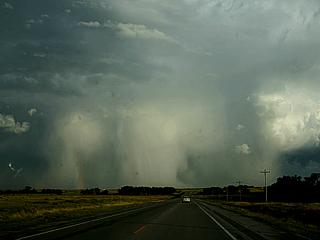
[Broken External Image]:http://www.stormchaserco.com/20050528_4.JPG
Intense rain shafts south of Burlington, CO

[Broken External Image]:http://www.stormchaserco.com/20050528_7.JPG
Rotating wall cloud tries to form west of Sharon Springs, KS

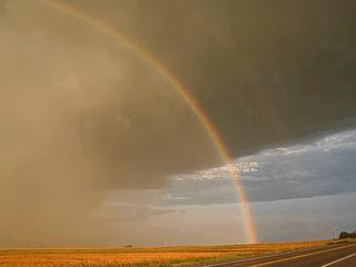
[Broken External Image]:http://www.stormchaserco.com/20050528_13.JPG
Nice rainbow south of Goodland, KS and we called it a day!
 
Headed out from Limon around noon and decided to recheck data at Burlington. Note: the Burlington library closes at 2, and they shut down their puters an hour before close. Doh! Anyway, still headed north from there and watched the storm with a severe warning for a few minutes. Rotating, but too highbased to do anything except look nice and green. Tried to maintain interest with an area of rotating updraft between an inflow tail and the hailcore, but no dice.

I totally failed to seriously consider NWS bulletin of a severe cell behind the line of storms N of Colby that evidently dropped a tornado in Rawlins county. We had no data outside a novice nowcaster, but did not think anything behind the line would be significant. I suppose it had a good boundary to work with and locally low LCLs but didn't imagine it'd have good inflow air. Oh, well.

Pix delayed as I'm non-digital :(
 
Jeff Gammons, Chris Collura, Kersten McClung, and I experienced an excellent chase day across southeast Colorado into the Oklahoma Panhandle. Tail-end charlie supercell exploded north of Springfield, CO and traversed southward to east of Boise City, OK into the nighttime hours. The storm contained highly photogenic opportunities including glowing white hail shafts complete with a full vivid rainbow, explosive convection, and impressive structure. By sunset, the storm transformed into breathtaking colors with a pink hail shaft and base balanced with insane cg lightning. By nightfall, the supercell morphed into a mothership structure with numerous striations. During the observed time, the storm produced three well-defined funnel clouds. Preliminary photos taken by Chris found below...

m6hails.jpg

m6hailbw.jpg

m6cg8.jpg


Scott Blair
http://www.targetarea.net
 
Status
Not open for further replies.
Back
Top