2017-06-28 REPORTS: IA/IL/WI/MN/MO/NE

chrisbray

EF4
Joined
Apr 24, 2012
Messages
474
Location
Bourbonnais, Illinois
I had my eye on Wednesday for a while, but hadn't really planned on chasing as my usual partner was unavailable and it seemed to be setting up too far north/west for my taste on a workday. However, as I sat down to work that day and looked at the trends, I liked what the RAP/HRRR showed for parameters in Eastern Iowa/NW Illinois around the quad cities area. HRRR in particular was very consistent in showing some high Updraft Helicity track coming from a few storms that fired in very good parameter space crossing the Mississippi River into Illinois. I figured, what the heck, I can drive 2.5 hours for one last chance to salvage what has been a pretty dull and disappointing chase season for me.

I left Bourbonnais around 1:30, gassed up and headed west on I80. As I progressed West, I occasionally stopped to look at data/gas up etc. It seemed the HRRR had started to change it's mind about the coverage and intensity of storms and I started get really flustered, but pressed on. By the time I got into Iowa, a line of tornadic supercells was well underway from Southwest Iowa towards Des Moines, while more storms were ongoing in North/Northeastern Iowa and trekking into the Wisconsin/Far NW Illinois area. I dabbled around the quad cities for a while, and eventually started to head west more on I-80.

When I reached the Iowa City area, it was as far west as I really wanted to go. Any farther and I wouldn't be getting home until after midnight. But the storms weren't even past Des Moines yet. I was sure this just another frustrating bust in a frustrating chase season. I had been dragged into Iowa for nothing, once again! I noticed a few storms starting to develop about 20 or so miles to the north and decided I may as well take a gamble on them developing in a favorable environment, rather than press farther west/wait on the storms moving from Des Moines. If that failed, it would be better to head home at that point.

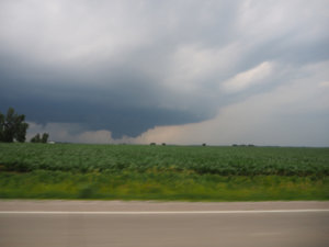
I took I380 north and tried to find my way past Cedar Rapids so I could be in a good spot to intercept if the storm kept strengthening. As I struggled to get to the Northeast side of the city and into open country, my occasional glances at radar revealed developing rotation.
72915b8ea635a2b2cbe1cb775800659a.jpgIMG_0096 by chris bray, on Flickr
98d322b9420840c9856063fe5fc55d4f.jpgIMG_0097 by chris bray, on Flickr
I finally broke through and was headed north for the intercept, and as the storm came in to view I was in total disbelief. This was already a fully mature supercell with a large, low hanging wall cloud.
[Broken External Image]:http://[url=https://flic.kr/p/V1G5j.../p/V1G5jb][attach=full]16149[/attach]P6280454 by chris bray, on Flickr

I continued the pursuit and found a road that was a direct intercept route. I can't tell exactly when the tornado "dropped" due to trees/hills, but here is my video as I approached it from the South (sorry I don't have any kind of dash mount in my vehicle so I had to handhold my camera in one hand and drive with the other)

At this point I was in complete disbelief as large, swirling cloud mass reach out at the ground below, merely a couple miles dead ahead to my North. As the road approached a river crossing, I realized this might be my best chance to get video of this monster, as the map showed the roads getting wonky by the river. I got as close as I could, and pulled over with an amazing view of the tornado on the other side of the river valley. (Note I didn't have time to set up a tripod so I apologize for some shakiness on the video.)

3e28392a0ffd1ab3b8c04bed32fb6c52.jpgP6280460 by chris bray, on Flickr

After a few minutes of video, pictures and gawking at the incredible storm, I decided to try and follow it. Ultimately I was able to catch back up to the storm after 5 or so minutes on a winding road down in the river valley without any line of sight, but the original circulation had become completely rain wrapped, and soon began to weaken as a new circulation started up on the southern flank of the storm. I followed it due east, tailing it be a couple miles, and thought a new tornado would drop at any moment. Unfortunately, it was not to be. I followed the storm to Monticello, but ultimately let it go as it weakened.

New storms approached my area, but never organized in the same fashion. I decided to give a shot at a storm moving in from the southwest that had rotation and tornado warnings, following it to Maqueoketa with the warning stating "confirmed tornado", but I was never able to see any of them, if they existed. Once I arrived at the town, it became clear pursuing it was not working out, and darkness was fast settling in, so I called the chase and prepared for the 3.5 hour drive home. For me, this chase absolutely MADE the 2017 season, a year I was certain I would only look back on as the worst I had experienced.
 

Attachments

  • 3e46a8c6900976cde01e3ff8b4eab6c5.jpg
    3e46a8c6900976cde01e3ff8b4eab6c5.jpg
    315.2 KB · Views: 7
  • 73ac036037c880804db01cb461a2eb0e._.png
    73ac036037c880804db01cb461a2eb0e._.png
    2 KB · Views: 0
I could not chase Iowa as I could not get the day off from work, so I had to settle for whatever I could get in NW IL. Drove to Savannah, IL at the state line to intercept the southernmost of the two cells moving into NW IL from IA. The cell I was on picked up a decent bit of low level rotation and maintained a decent rotating wall cloud for the majority of the time that I was on the cell. I then stuck with it until it became embedded within the blob of cells that passed into IL from WI, where it picked up its first Tornado Warning just to the west of Rockford. After the initial merger, the storm itself began to take on a bow echo look on radar so I decided to just continue past Rockford to get ahead of it to take a look at the structure and planned to continue down I-90 towards home(pardon the crappy stitch job my cell phone did when I did a panoramic shot of the shelf)
efc895c1d09f296932b28d8312bb0532.jpg

While watching the shelf approach I noticed the structure of the easternmost edge of the shelf was beginning to take on the look of a inflow tail cloud rather than a shelf and saw that the bow seemed to be developing an inflow notch so I decided to just skirt along the front of it to see if it would do anything. Sure enough the bow echo managed to full re-organize into a Supercell and became Tornado Warned once again near Belvidere. By this time I was on I-90 heading southeast and the storm decided to take a turn towards the south and the couplet began following directly behind me. At about 8:23pm I decided to pull over on the shoulder of the interstate to take a look and see what was going on behind me and noticed very significant rotation just off the interstate about a mile or two to my WSW. I did record this, but unfortunately I did not have the camera set up properly for night time video. Despite this the rotation is very apparent and a decent sized funnel eventually comes into view. At the time I could not visually tell if circulation had made it to the ground or not, but a damage survey done by the Chicago NWS office confirmed it as an EF-1 tornado, along with another prior to it that I could not see through the rain as I drove down I-90.

Tornado damage path:
b2d207fddf7d9378d70c6cd83b7c5c96.jpg

My position at the time of the video:
132ea03397737582d710d437f49ededc.png
Honestly hadn't expected to get anything, so overall I'm pretty happy with how things turned out!
 
Probably the lamest chase day of 2017 for me on Wednesday. I usually have 1 day a year where things just don't go right and Wednesday was that day for us...especially given what happened in Iowa. First off I didn't expect convection to initially fire so far west, I had been targetting the Ottumwa to Oskaloosa, Iowa area perhaps up to the I-80 corridor for the potential of supercells and perhaps a tornado or two. I wasn't exactly sold on any long lived tornado potential or visibility because I thought storms would be fairly high precipitation. Anyway I knew that the highest low level shear would likely exist across Northeast Iowa and I noted this as a secondary target. My chase partner and I ate lunch and set out of Galesburg around 1 oclock when disaster struck for the first time. His car was broken into and a bunch of chase gear stolen. So that burnt a couple hours, waiting for police to show up and file a police report. I refused to leave without him, so we finally got on the road around 3:30PM heading up 74 on 80 westbound. When we got into Iowa City, disaster #2 struck....the car sprung a major oil leak. The oil sending unit failed and if we hadn't stopped when we did, we would have risked locking the motor up. Luckily for us there was a auto shop right off 80 and we were able to get the owner to bring us some oil and get a lift to fix the vehicle in his shop (huge shout-out to Simpson Motorsports in Iowa City!!). We finally got the car fixed and were on the road around 6:25PM. By this time, the show was already well underway to the west and convection firing to our north. We decided to try for the cells approaching the Cedar Rapids area. Unfortunately for us, the car repair took a little longer than expected and we missed out on the Prairiesburg, Iowa EF2 by 25 minutes, nabbing the cell that came in behind it. It produced an elephant trunk funnel that came halfway down and then dissipated. The cell pretty much crapped the bed after that. Supposedly DVN confirmed an EF-0 in this area (near Vinton), but I never saw ground contact, so I'm not counting it. Pretty lame chase considering everything that happened, but it could have been way worse. Luckily for my chase partner, we were able to recover his belongings later on and made it back home in one piece, that is all that really matters.

Here is the only photograph that I took on this chase outside Vinton, Iowa

116ff73dc24f36a68b71b93777dbd134._.jpg

Overall it was kind of disappointing, but again everything that happened was well out of our control, so nothing we could have done about it. Sometimes you just have those types of days, it all comes with the territory of storm chasing, its not a perfect world we live in....unfortunately lol
 
I had been interested in Western Iowa for several days beforehand, however I knew I wouldn't be able to chase very far due to time constraints. I arm-chair chased the event in Western Iowa and watched multiple tornadoes unfold, relatively bummed I couldn't chase it. All I could do was wait and hope that either the storms held on somehow, or more likely some more storms developed out ahead of the original storms. This is exactly what happened.
A storm cell went up near Vinton and gradually obtained supercell characteristics, I made the decision to pick up the storm as it passed N of Toddville. The storm produced a brief funnel cloud in the 1st picture that dissipated after 2 minutes or less. But a large wall cloud developed NE of Alburnett and this put down the Prairieburg tornado which featured decent motion and a few horizontal vorticies. I followed until it became rain wrapped from my angle and dissipated in the rain. I then waited south of Praireburg on a secondary base that had some supercell characteristics, but this storm ultimately didn't do much. Fantastic local chase, and for once the storm came to me, when I couldn't go to the storm.


Here's my rockstar iphone pictures and a video. I'll need to invest in a better camera at some point along the line here.

EDIT: somehow deleted all of my text. gotta re-type it.

ff15bb8162e109c6be4f14d60a7933b6.jpg

2ccec9739116cef09514bcab9c22af45.jpg

8c587439c7093f9a1443f6d586cf99c0.jpg
743df9eedf3e4e59584e0b07758b60ea.jpg


Last edited:
Chased Iowa and targeted the west side of Des Moines. I hung out at the intersection of interstate 80 and 35 waiting for initiation. Storms fired in a line to the west. I went south on 35 and meant to go west toward the north cell but I missed the exit because of the construction on 35. By the time I made it to Winterset, I could see the wallcloud in the distance near Stuart and shortly afterward a tornado was confirmed. From then on it was desperate catch up. However the perspective as I approached was cool because the center of the tube was transparent.

From a distance
e4d21aa98ff84a94ffbe138ed5a08964.jpg

Still far
243d5640f45572bc92fa4a72d17cc0e5.jpg

Closing in
56c85553ddc1fe0918c69d38d91d7b35.jpg

Drilling
f903ad55b1788fb6178fb88097655d99.jpg

2 Miles
1621b22a9fafc107fce18612927e7f39.jpg

Crazy rope out
60d7b23dc92963fe83eed914178412f1.jpg

Got on a few more storms to the south of this one when it approached Des Moines, but they didn't produce. Here's a low wallcloud on the second storm south of the Stuart storm.

2895e44c9f42a2a3f0e3db9b284f7dce.jpg

Sent from my SM-G955U using Stormtrack mobile app
 
Started the day in Omaha and headed east with the idea of targeting the warm front/windshift line extending through eastern Iowa into Illinois. However, I stopped in Stuart to reassess (and talk in ChaserChat) and eventually dropped south to Cresston to wait for initiation. I'd never been in southern Iowa before and was surprised by how difficult it was for me to get a decent data connection. This partially contributed to my being late to leave town even when SPC mesoanalysis painted a moisture convergence bulls-eye over Nebraska City, because I was worried about losing data altogether. After a stout cell went up in the area of enhanced moisture convergence I tried to pick my way south and west to get into position on that cell, bearing in mind possible storm motion in between the sporadic radar updates that I was able to get.

I was finally able to get on Road 2 heading west out of Clarinda and stopped west of the 215 Street intersection to photograph the storm and maybe find a south option to allow it to pass by.

20170628-DET_7837.jpg

7 seconds later there was a visible funnel and the idea of waiting for the storm to reach my position went out the window.

20170628-DET_7838.jpg

Unfortunately I hadn't expected to get a tornado so soon and thus hadn't prepared my gear ahead of time. So what ensued was a rather hectic drive-and-video including segments with no focus, looking at the car ceiling, etc. I made my way about 2 miles west and then stopped for a nice view of suction vortices and flying debris. I edited out the really motion-sickness-inducing bits in the following video.


The tornado was a bit over a mile distant at this point and headed straight toward me, so I did a U-turn after a rather uncomfortable period of waiting for traffic to clear and headed a few miles back east. The rain curtains were still swirling at this point and there was a bit of a bowl/funnel above, but there was no longer a visible condensation funnel reaching the ground.

20170628-DET_7845.jpg

The Yorktown cell looked clearly outflow-dominant as I passed back east through Clarinda, so I dropped south on N26 to try to get in position on a newly tornado-warned cell to my southeast, passing south of Bedford. As I passed south through Siam and turned east on J55 I could clearly see a funnel and eventually a tornado, maybe 10 miles distant and to my ESE. From GPS timestamps I think this must have been the initial stages of the Bedford EF-1 tornado, prior to its getting wrapped in rain. Unfortunately due to the hills and trees, good views were intermittent and there was no place to stop along the road for photos or video.

Trying to get closer to the tornado, I took 308th Way east (which is gravel) but missed that it turned into dirt/mud at a T-junction with Hillcrest Ave. I got stuck in the mud (but luckily not in the ditch) and that was all for the day's chasing, since it took about 2 hours for a tow truck to come out and another 30-40 minutes to complete the extrication. Luckily I was out of the path of any severe, although I did get multiple rounds of rain and hail while sitting helplessly on the road.

After the guy from Southwest Iowa Towing and Recovery had fished out my car, I made my way into Bedford to chill out and assess the situation. There were some more tornado-warned cells south of the IA/MO border, but I would have had to punch through heavy precip and I decided not to push my luck any more for the day. I headed back to Council Bluffs for the night, catching some decent mammatus along the way. There was also some gravity wave action along the edges of the anvil.


20170629-DET_7863.jpg

20170629-DET_7870.jpg
 
I initially thought that the best play this day would be along the warm front somewhere in eastern Iowa, so I arrived at my target of Iowa City just before noon, where I had a quick lunch. But lingering precipitation across the northern half of the state eventually convinced me that the best area of destabilization would probably be just ahead of the cold front as it moved across southwestern Iowa, so I hurriedly made my way west on I-80 to Des Moines. Once there, I faced a choice: head north on I-35 to intercept a long-lived cell well east of Sioux City that had yet to do much, or continue west on I-80 and take a chance on two small cells that had just gone up a couple of countries west of Des Moines. I chose the latter, and as I approached the exit for the small town of Stuart, Iowa, the southernmost of the two storms began to show something of a hook:

2017-06-28ia#4.png

I blasted south on County Road P28 in an effort to get south and then a bit west of the storm. Much to my surprise, as I approached Greenfield, Iowa on IA-92 the storm put down a small but unmistakable funnel cloud several miles to my northwest. I called in my report to NWS Des Moines, and they too seemed a bit skeptical. I then retraced my steps and headed back north on P28 as the storm continued to produce a series of short-lived funnels. Once I got back north of the cluster of homes that makes up Arbor Hill, Iowa, though, the show began in earnest. These photos, which look northwest from P28, show the beginning of the storm's tornado:

056.JPG 071.JPG

The tornado then crossed P28 about a mile and a half to my north before passing behind a clump of trees:

187.JPG 206.JPG

The tornado then began to dissipate, roping out very slowly (and quite beautifully) as it passed to my northeast:

218.JPG 221.JPG

By this point the cold front had unzipped all the way to the cell that had earlier produced the Shenandoah tornado. I made a half-hearted attempt on the tornado-warned storm just to my south, but only ended up getting cored near Macksburg, Iowa. I then slowly made my way north to Des Moines for the night, content in knowing that I had witnessed a nice tornado in much-maligned Iowa on a road where I saw only one other chaser!

Here's my dashcam video of the tornado's entire life cycle:

 
Last edited:
I chased this day in southwest/south central Iowa and into northern Missouri. Unfortunately didn't see any of the numerous tornadoes. My chase partner and I initially were going to head east towards eastern Iowa. After a lunch stop just east of Des Moines about 1p and reassessing, we decided to head back southwest to southwest Iowa. So we drove over 3 hours to end up 1 hour from Omaha. Sigh....
On the way back southwest, convection formed along the Iowa/Nebraska border and the tornado watch was issued.
We made our way to Creston and then Corning as we headed towards the tornado warned storm near Shenandoah. New cells were forming near Corning and northeast of there and the one closest to us near Corning was starting to become more organized. My chase partner and I had the brief discussion of staying with this cell as it started to spit out numerous positive CG strikes, but we decided to head on towards the tornado warned storm that was still 30-45 minutes away. The Corning storm and the storm near it went on to produce confirmed tornadoes including the pretty Stuart tornado.
There were reports of a confirmed tornado on the ground all the way up until about 10 minutes before we were able to get to the Shenandoah storm, and as we pulled up to it just west of Clarinda, just a large wall cloud remained.
We then noticed a nice storm to our south along the IA/MO border and from our vantage point could see a wall cloud forming. As we headed south on Hwy 71, we watched a funnel form and drop about 1/2 to the ground as we looked to our southeast. The next road was was just across the border in Missouri and was a skinny, rolling road that made it hard to go fast, not to mention the heavy rain we encountered.
Our storm was heading northeast towards Bedford, IA and had a tornado warning, and as we headed back north on Hwy 148 we began to encounter heavy winds and rapid motion in the sky/clouds above us. We were now just a few miles behind/west of the Bedford wedge, but couldn't see anything due to rain and hills and trees.
Eventually we made our way east out of Bedford and then back south into Missouri. The now line of storms was sagging south but still had strong areas of rotation and tornado warnings with it into Missouri.
Our last storm of the day was near Worth, MO. This storm looked like a beast and was very HP so we couldn't see anything back in the rain despite the strong rotation showing up on radar. After this we called it a day and headed back home to Omaha.

6281.jpg Wall cloud west of Clarinda, IA


6282.jpg 6283.jpg

HP storm near Worth, MO
 
Back
Top