5/25/06 REPORTS: MI / OH / IN / KY / TN / MO

Joined
Feb 29, 2004
Messages
4,133
Location
Rochester Hills, Michigan, United States of Americ
I was going to post this in the NOW thread, but I think it's more of a report.

I was on the squall line in MI, positioning myself on top of a large hill near the Oakland/Macomb border to intercept. The thing looked pretty good, especially on the high resolution/unsmoothed doppler from the local TV station. Damage reports were coming in of snapped utility poles, downed trees, and estimated wind gusts of 70MPH...

Unfortunately, a lake breeze shot off from lake St. Clair, dropping temps to around 70F with a nice 35MPH gust from the WSW... This was ingested into the squall line and put an end to my little "chase". So what I got to see was the shelf cloud/gust front over in western/central Oakland county morph/detach into a fast moving roll cloud with a little rain and a whopping 10MPH gust.

I wish I had the resources to head out to some REAL storms, I don't care where they're at.
 
Badly "photoshopped" panorama of slow-moving storm which has lingered in Barry/Stone Counties, MO for the past 2-3 hours northeast of my town (Bentonville, AR...photos shot from Centerton, AR)...first noticed as an anvil in McDonald County, MO immediately above Benton County, AR around 5:00 PM behind multiple cumulus towers...storm appears to have moved 40 mile E/SE in approximately 3 1/2 hours:

storm.jpg
 
Ho Ho Ho! Merry Christmas!!

Our gang also wound up in S. IN. We managed to observe a train of severe cells which tracked through N. Spencer County. We were late for the initial development S. of I-70, but watched explosive development just to our southwest while stopping at a convenience store in Princeton, IN. We drove beneath the organizing updraft and jumped on I-64 eastbound to keep pace. An RFD quickly worked into the updraft, and a moderately strong rotating wall cloud ensued. This feature continued east along I-64, but no significant tornadic development was observed. The cell seemed to become outflowish early on and HP in character and the action area became undercut and wrapped in rain. From Dale we drifted southeast and south to Santa Claus (yes a real town) as additional severe cells exploded to the west. Two tornado warned cells proceeded to move east over Santa Claus and vicinity. These also featured temporal wall clouds which quickly became wrapped in rain and hail. We made a couple of stops at cemeteries in Dale and Santa Claus to collect hail up to 2" in diameter. Area fields and gullies were flooded, but the roads were passable for the most part with only minor problem areas. Terrain wasn't the greatest, but it was managable. The last supercell cleared Santa Claus around 7 PM and it was time to start back for OKC. During our pizza stop in Lynnville, we were treated to the best mammatus display I've ever seen.

Within a 2 hour time period, Santa Claus was in the path of 3 training stoms all producing 2" hail or larger.

Pictures to follow.

Happy Holidays!

Scott Weberpal
with Bill Reid, Brad Carter, Doug Raflik, and Rudolph
 
Well, I watched the radar, for a while, and I saw a pretty former severe cell headinh NE by one county, so I immeaditly began watching for wind and lightning. The wind did pick up a bit, and the lightning was very good.

lightning34lb.jpg


lightning22io.jpg


lightning11gu.jpg


lightning48gv.jpg
 
What a loooong day. I wound up on the storm that went through or just north of Frankfort IN. It was pretty darn intense. It was a pain to catch up to it with the traffic and towns in the area. It got a decent rfd cut before it got there. Then as it neared Frankfort it really got intense. I was a tad frustrated finally starting to get caught up and saw the city show up on my gps. As I entered town tree branches were shreading and crap was flying everywhere. I kept getting rapid changes in the winds too. One point a construction barrel goes flying south. well off the ground. It looked like it hit the top of a semi in front of me. It was a bit spooky driving east near any larger trees. So I head through the city and midway in I see traffic stopping well east of me. I figured something was blown over so I quickly take side streets. Well that wasn't any better. The first one I turn to go back north to the highway on has a large tree laying across it. I finally get out of the city and still get to mess with slow drivers. I ended the chase several miles east of there around 5 pm I guess.

FYI for anyone that doesn't already know, Chicago is a mess on the south side of the city....jeeeesh. I went through there around 6:30-7:00 pm tonight and cringed when I saw the sigh saying construction and to expect delays.

Time to finish this long a$$ day and get home.
 
Thursday, May 25th: Supercell/Lightning Fest!!!

Well after yesterday's disappointment we were supposed to have a relaxing off-day. Then we saw the Day 1 SPC outlook, once again showing a marginal supercell/tornado threat, this time for southeast MO. Well we knew it was a crapshoot, but we wanted to chase anyway. We then tookoff through the Ozarks. We watched as cumulus clouds bubbled up and down, weakening the cap, and getting sheared by the jet stream. One group of cumulus persisted and turned into a shower. Other showers and thunderstorms began to pop. Then a Severe Thunderstorm Watch was issued. Our little shower was quickly becoming a severe thunderstorm, and even more, a supercell! As we reached Poplar Bluff, MO. A Tornado Watch was issued. Our supercell was looking great and classical despite the high base. The magical words then sounded on weather radio: TORNADO WARNING!!!!! We tookoff down a road twoard the towering beast. Hail smacked the car as we approached and the rotating updraft base came into view. Thunder and lightning was crashing all around us. New updraft bases in the area were also becoming supercells, but we were on the strongest storm in the area! How is that for luck? We followed the cluster of supercells, capturing great shots of mesocyclones, wall clouds, and even a couple funnels, but no tornadoes. The storms evolved into big green mass of rain, hail, wind and pure electricity! What a fantastic chase!!!

And there will definitely be pics later!
 
Today, we (Matt Robinson, Tom Mullins, Dave Draun, Kurt Hulst, Nick Grillo and I) made a last-minute decision to chase the surprise supercell setup in southern Missouri. We left Joplin at noon and headed east to the bootheel region of the state, watching storms develop as we approached our target. We observed several very photogenic supercells between Poplar Bluff and Sikeston, albiet high-based. We witnessed several wall clouds, RFD notches and possible brief funnels, but no tornadoes - although several of our storms were tornado-warned through most of their observed lives. Matt has some awesome Canon 5D structure shots from these storms. We ended the chase along I-55 south of Miner, where we were treated to an amazing light show. Everyone caught nice lightning shots on their respective cameras. I filled a 60-minute tape with great lightning. Here are some shots:

may25a.jpg


http://wvlightning.com/2006/may25a1.jpg
http://wvlightning.com/2006/may25c.jpg
http://wvlightning.com/2006/may25d.jpg
http://wvlightning.com/2006/may25e.jpg
http://wvlightning.com/2006/may25f.jpg

We are likely going to bypass Friday's setup in western Kansas in order to make the long drive to a probable North Dakota chase on Saturday.
 
I chased a couple supercells today in central Ohio, one being the tornado warned cell that had a possible funnel over Indian Lake, but due to the massive amounts of rain, there wasn't much structure, besides a small couple glances of a pretty good lowering. The second storm pretty much found me as I was driving home, a nice fat HP that decided to swallow me whole while I was in the town of Plain City. The rain core at one point looked like it was rotating around the storm, a rather awesome sight.
 
Frustrating chase day in western Indiana to end our trip. An almost perfect-looking supercell went up less than 15 miles south of Terre Haute, where we had stopped to re-evaluate, but the road network and terrain didn't allow us to get around it where we needed to be. It went tornado-warned within an hour with spotter reports of a funnel cloud and a possible tornado but we were on the wrong side and the storm accelerated away before we could get around it. Then it mushed into a complex of storms. Chased some other smaller cells through the afternoon and evening but nothing spectacular came of it.

After chasing North Carolina, Illinois, Colorado, Nebraska-South Dakota, Wisconsin and Indiana in this unusual storm chase trip, our 12-member group from Virginia-North Carolina heads back today. More on our trip on my weather blog.
 
Rand McNally shows that lots of S IN is Hoosier Nat'l Forest, so I refused to go there. So, having left NW IL in the morning, I targeted E IL/W IN, and witnessing the curved band of convection as I approached Champaign IL in the early afternoon, I chose to get out in front of it by driving (on I-74) to US41 inside IN and then dropping a bit S for better parameters.

The journey down to I-70 convinced me that that part of IN is unchaseable, and that my best option was to just chase back and forth (if need be) on I-70, for better or worse, so that I would at least have the nice, wide, interstate right-of-way to at least provide SOME visibility. The best-laid plans of mice and men, I went through Danville IN on four separate occasions, LOL.

Well, it was quite a convection-fest, and there were storms everywhere, but they all crapped out just as soon as you expected armeggedon. Needed cap? Needed more CAPE for the jungle moisture? Stronger shear? Anyway, I also can't believe what happened based on the models. Excuse me, but did the models not prog the storms to be in W IN or even E IL at 00z?? They were in COLUMBUS OHIO AT 00z. Has anyone ever, ever, seen the models so wrong? Maybe the convection was forced by something other than what the models were "thinking".

Glad I got to IN early.

Sorta.

Fun chase day, really, in spite of it.

Here are a couple pics of a storm just E of Terra Haute (though different from the one Kevin mentioned. That one was SW of this one, and already dead when I snapped these) which, like every other storm on the day, looked **insert your favorite adjective here**, then immediately the updrafts simply ceased.

Bob


(click to view larger versions)

Here's another storm over New Winchester (on US36 W of IND) that produced some funnels just before I shot these, exhibited some moderate meso rotation, and had this great looking shelf for a brief time.


My oldest girl (Sierra...3yr old) out on her first storm chase


Also a funny movie of me trying to get the camera at her size so she can shoot a beautiful sky after the storm passes

http://ldm.allisonhouse.com/movies/sierras-first.avi 36Meg


Nothing of note to report really. I was in south east Indiana (Ripley County) and the storms seem to just fall apart when they got within 10 miles of me. Bah!

-Tyler
 
Strange day when the plains folks come to visit our Great Lakes states.

I was not home in Ohio so I had to drive there from Kentucky. We got into Cinci just at about initiation time. The IN tor watch had gone up the Ohio oMD was up and the OH watch was just about to go up.

Som cells where heading east at 25-35 others where NE at 45 mph ? What is up with that ? differing sides of the rotation around the low, bad measurements, who knows. Tried to get near Dayton for some initiation in ohio ahead of any line but the line seemed to become the dominant feature. It was a t least a line of more or less temporarilly discrete cells.

We picked the tail end of the line above Cinci, actually the town of Oxford. It was tor warned as it crossed th border but weakened once we got there. By then it was getting lateish and the KY watch box was up so we were able to chase back home, well our temporary home for the weekend in KY.

Fun day, too high of a chance to let it go. The midwest teaches you some hard chasing lessons. It is always a last minute forecast and soooo much can go wrong. I know that is true everywhere but it seems like East of the Mississippi is a little more fickle than the plains. Usually too much cloud cover, that was not the problem thursday but storm mode turned out to be. Those darn storms just refused to rotate.

--
Tom Hanlon
 
COMPLETE MAY 25, 2006 STORM CHASE REPORT CAN BE FOUND AT THIS LINK!

I'm a day late with this report and I apologize, but seeing as I ended up chasing straight into my hometown, I had to visit with some very old friends. I took the evening off tonight to get caught up on things and share with you one of my most important chases to date..

I moved from Ohio to Colorado in April of 1998 and it was in the Mile High City where my storm chasing career officially kicked off back in 2000. I stated early on that one of my life-long chasing goals was to chase a system from Colorado to Ohio. The likelyhood of such a trek would be very hard considering one of two things would have to happen; the system I'm chasing needs to aim itself for the midwest and have nothing too close behind it which would send me back west before the system made it out here; or two, I would have to give up on the following system in order to follow the current one into the midwest.

I woke up early in the morning at our hotel in Bloomington, Illinois and immediately ran over to the nearest Wal-Greens to get a repair kit for my glasses which broke the night before. When I returned to the hotel, I moved to the lobby for free hot breakfast buffet and data. Low and behold, I saw the 10% tornado chances in Indiana and Ohio and flew out of my chair with a big "YES". I was chasing home.

Our initial target was Indianapolis, a bit further east than most chaser's target, but after yesterday's chase, we wanted to be ahead of storms so we could reposition for easily for any number of reasons. So with that plan in hand, we headed out of Iowa to the Indianapolis area where I treated Chris to my favorite pizza place on earth; Donato's. We stopped in Plainfield for that, west of town, and got ready for the action.

The watch went up as we ate, and after stuffing ourselves full of food, we headed down to I-70 where we met with David Diehl in Mooresville where we topped off and I replaced my crappy-ass Radio Shack speaker and did some minor rewiring. Towers were going up everywhere and fast, so we dropped south, then west towards Eminence and Cloverdale before continuing south on Hwy 231 towards Spencer to get in front of a tornado warned cell heading towards the Bloomington area.

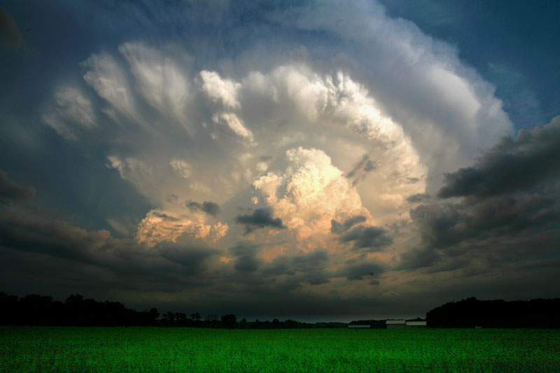
When we arrived near town, the storm was about 15 miles west of us. Trees and hills made this a nearly impossible catch. Couple that with a faulty WX Worx system on my end and a GPS which was showing us driving through open country around the area. It wasn't a pretty sight. We were fortunate to find a long driveway with a semi-decent view to the west where we sat and waited as the tornado-warned cell moved in. Some lowerings were observed, but nothing rotating.

As the storm moved into the area, we jumped into town only to get turned around by loads of traffic. We then saw our best shot at this storm took us along a highway (IN-46) which cut through a State Forest. We elected to give up that storm and move north for the tail end of the northern line and more favorable terrain.

That meant Indianapolis at rush hour. Fortunately, the state capitol was more forgiving than the route we took to get there. We wanted to get east to at least I-65 because we knew we could travel faster AND avoid the lights which were killing us. We went north on IN-37 then cut over on IN-44 out of Martinsville, a road which was taken directly from that "walk in the woods" scene in Twister. We flew through Franklin to I-65 and into Indianapolis where we made a brief attempt to go west when I finally decided that our best hope was to get east of town.

We chased down the squall line to near the border where we pulled off to evaluate our situation near the IN/OH border. David decided to call it off and Chris was going to do the same after he crossed into Ohio. We said our goodbyes via the HAM and I continued east into the Buckeye state where I got slammed with traffic in Dayton. Fortunately I was stopped right at the I-675 exit east of town and to avoid sitting forever, crossed three lanes of packed freeway and flew downHwy 68 towards Xenia.

About this time, a tornado warning was issued for an embedded cell in the line for Greene County. I punched through the storm and barely got ahead of it near Jamestown and observed absolutely NO tornatic activity. The warning was allowed to expire as the storm weakened. I let it pass over me near the I-71 junction and continued to follow it into Washington Court House as the lightning behind it was spectacular. I then jumped on Hwy 22 and chased the storm straight into my hometown where I called off my chase.

My long time chasing dream became a reality as I crossed the city limits. An unreal adventure for my storm chasing career in which over the course of five days, I chased the same system from the Colorado Front Range all the way to not only my homestate, but my hometown! Something I know many chasers will never be able to do on the magnitude which I did. It was great to see old friends as I brought my porcupine ride and its toys back home. And in the midst of one of the worst chasing seasons on record, I can say I accomplished what could easily be the biggest, most important feat of my chasing career. I made it to my hometown, and as Dorthey form the 'Wizard of Oz' would say...

"There's no place like home..." And I made it back home on the wings of the wind...

COMPLETE MAY 25, 2006 STORM CHASE REPORT CAN BE FOUND AT THIS LINK!

060525d.jpg


060525f.jpg


060526c.jpg


COMPLETE MAY 25, 2006 STORM CHASE REPORT CAN BE FOUND AT THIS LINK!
 
5-25-2006-406587.jpg


5-25-2006-406572.jpg

Large supercell south of Bloomfield, MO

I watched probably the longest lived supercell of the day -- in southeast MO -- grow from a non-precipitating cumulous cloud to a large, prolific supercell (which dropped baseball sized hail -- destroying numerous cars near Essex). It's too bad that the large surface Td depression induced a higher LCL across the region... I believe if we would have seen lower surface temperatures, this supercell would have produced a tornado. It was relatively-isolated and established for 2-3 hours...

I'm chasing ND today, so I'll get more pics up and a whole page completed by Sunday, hopefully!
 
Back
Top