5/24/06 REPORTS: MO / IL / IA / WI / OK

John Farley

Supporter
Joined
Apr 1, 2004
Messages
1,828
Location
Pagosa Springs, CO
I had a good chase today in Missouri and Illinois. No tornadoes, but lots of interesting storm structure, a gustnado or two, and some wild cloud motion. Intercepted first storm in Pike Co, IL just across the river from Louisiana, MO. It promptly surged southeast, cutting off any plans I had of following it into IL, so I cut back into MO and headed south to intercept the next storms forming to my southwest. As I was leaving it, I did notice a brief, narrow dust formation which may have been a gustnado or may have just been a narrow plume - didn't last long whatever it was.

Once I got to the storms to the SW, I caught a nice wall cloud northwest of Troy, MO. Then another storm just to the south of that one went severe, and I ended up pursuing it all the way east to Highland, IL. It intensified near Wood River, IL, producing wind damage in Roxana and golfball hail near Edwardsville. Then it really kicked up a LOT of dust from Marine to Highland, producing a brief gustnado near Highland.

Another storm to the south then began to merge in, and I pursued this storm east to route 127, as it produced large hail in southern Bond Co. Here are a few pics:

chase52406_1.jpg

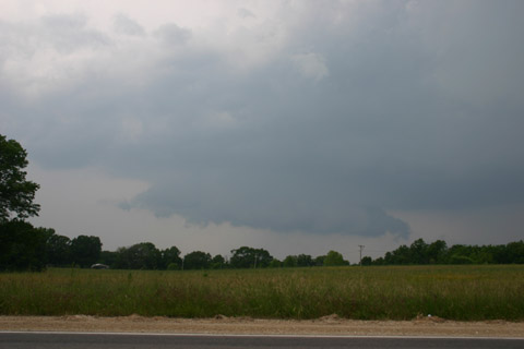
Wall Cloud northwest of Troy, MO

chase52406_2.jpg

Looking north from just SW of Edwardsville, IL, toward the SIUE campus

chase52406_3.jpg

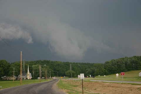
Storm produces lowerings near Marine, IL and kicks up lots of dust

chase52406_4.jpg

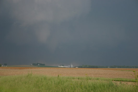
Gustnado just north of Highland, IL

chase52406_5.jpg

Blowing dust entering north edge of Highland

A full chase report is now available at http://www.siue.edu/~jfarley/chase52406.htm
 
Made my first official chase today, thanks to Jim Westover. I had already photographed the storms approaching from western Dane County when he arrived at my house about quarter to 7. First we headed west and then north to the intersection of Highway N and I-90, where we were nearly overtaken by a shelf cloud and associated gust front which triggered a blowing dust cloud in a dirt driveway nearby. Then we headed south toward Edgerton, staying just ahead of the gust front. We were stopped at a truck stop north of town when our nowcaster, Alex Lamers, notified us that some mid-level rotation was headed our way. We headed south and then southwest through Edgerton on 51; toward a raggedy-looking lowering that at times looked suspicious, I.E. it looked like an attempted RFD cut-in with a clear slot.

From here we headed south to Janesville, observing another lowering before getting caught in a deluge of near-blinding rain. Alex advised us that the most promising area (tail-end storm with weak rotation) was now northeast near Whitewater. We busted that way through Milton along highway 59, but remained surrounded by heavy rain with no discernable cloud features. From Whitewater Alex said we should head south about four miles; we did so on highway 89. The rain refused to let up, and although it was heavy enough to reduce us to near zero visibility, no hail ever mixed in. After waiting south of Whitewater we decided to give up on trying to get ahead of the storm and headed back north as the rain slowly cleared, finally allowing us a view to the west. It was actually here where some of the better shots of the chase were obtained; with a nice sunset mammatus display and lightning strikes on the back side of the squall line. Jim brought me back home around 9:30 and faced a long drive back to Milwaukee.

Thanks to Jim (and his girlfriend Leslie) for making an awesome first chase possible; and to Alex for some top-notch nowcasting!

Photos and video captures later

New chaser out

:D
 
VIEW COMPLETE MAY 24, 2006 STORM CHASE LOG HERE!

Another day, another state! Illinois doubled up today for a new traveled state and was added to my list of states chased in 2006. And for what its worth, come 5pm, we thought we were busting. Then nature came through with a good show that filled the final two hours before dark. Chris Collura and I kicked out of Sioux City, IA around 10am, filled up, and shot out to Des Moines, IA where we elected to shoot southeast towards Burlington, Iowa. We passed through the town made famous by Radar in M*A*S*H before continuing on south where we met up with Brad again and continued across the river into Illinois.

We stopped at a picnic area just across the border where we discussed our options. We thought that we were dead in the water. A dry slot had punched in and the cu we were watching literally vanished before our eyes all around us. Our options north were remaining, but we thought we'd end up in Wisconsin. Fortunately some towers about 50 miles to our north near Moline, IL were giving us hope. We then blasted north on I-74 our of Galesburg and caught up to the first storm at the tail end of a line coming out of Wisconsin.

At this point, we headed east/northeast on I-88 towards Chicago. Our storm intensified and went severe warned. We jumped ahead of it and stopped several times off the interstate before it became a toll road. We then worked north and around the storm from the town of Sterling, a traffic-light infested town which slowed us up. My tactical decision was called into question as the storm turned right and began to move due east which would take it south of the interstate and along Hwy 30 which I elected to pass on. Fortunately, it probably paid off in terms of the most photogenic point as the storm split and cleared a path to our southeast along Hwy 52 out of Dixon where we drove directly between the splitting storms. We then began to see the groups of chasers, including the TIV, a DOW, and various other chasers including another pair from Colorado.

We stayed with the storm along 52 into the town of Mendota where we moved over to I-39 and dropped south in hopes of catching more development to the south. Within 15 minutes, XM showed the storms weakening, thus we called it a day and made a brief stop for lightning before venturing to our Best Western in Bloomington and dinner at Denny's.

VIEW COMPLETE MAY 24, 2006 STORM CHASE LOG HERE!

060524d.jpg


060524j.jpg


060524p.jpg
 
Wound up in northcentral IL today. Got on a decently structured cell se of Rockford(perhaps it was a supercell...it looked nice but was starting to ingest the cooler air in the area from the other convection...at least the base was a lot closer to the surface this way!). This was a bit after getting a ticket....a ticket for no seatbelt :rolleyes: . While heading north in a small town a cop goes by heading south. He flips it around behind me and pulls me over. What a joke. All the harmful things you can do to yourself but you can't opt to drive and not have a seatbelt on(he didn't stop me for any other reason). He also kept me stopped there for longer than any stop I've had(just when I was finally starting to catch the darn line of towers). The funny thing is I wear my seatbelt 90% of the time I'm chasing. I speed far more than I drive without a seatbelt on. Sigh.

Anyway, I was somewhat happy with the structure finally displayed se of Rockford. I went east with it and then left it and intercepted the southern one at Dekalb. I never got ahead of that one(storm motion was pretty fast). I wound up under the shelf as I punched it going south. I then went west and took some lightning photogaphs as it entered Chicago. I really didn't think I'd have to go into IL today(first time chaisng IL). I was a bit shocked when I backed out the gps and saw I was only a couple counties outside of Chicago.

I hope the night photos came out nice. They look cool on the lcd with the twilight light doing its thing. The stars were shining above the wind blown anvils, with a few cgs on the horizon, and some added light from Chicago. The more I take the time to stop and shoot those settings the more I wonder why I don't put more effort into them than I do some of the crappy setups I'll chase. They can certainly help out a less than great chase day.

Images later.


EDIT: LOL A minute after I send this I hear a "click it or ticket" commercial on the tv behind me. There is some nationwide thing going on this weekend I think. *grumble* I'm staring at every cop I see now. If they aren't buckled up I'm making a citizens arrest.
 
Interesting chase today for our Virginia-North Carolina group in southern Wisconsin, following a long daylong drive from South Dakota. The most interesting part was watching a wall cloud form in Green County, Wisconsin, hang very low toward the ground, and then a sudden tightening of the mesocyclone producing a rush of wind and atomized rain toward it. Dave Carroll and I believe it is possible that a tornado may have briefly touched down, but have no way to prove it, though one of our lab support guys back home says a TVS appeared for one frame of Weathertap in that area. The National Weather Service also mentioned "weak rotation" in its severe thunderstorm warning at the time.

Also saw some other tremendous storm structure with shelf and wall clouds. A couple of photos below.

wiscwall1a.jpg


wisconsinwalla.jpg


More on our 2-week chase trip in my weather blog.
 
Andy hit on the high points above, but I wanted to mention the torrential amounts of rain we had to deal with up here in WI. I hope it was better for you guys in northern IL because we needed a pontoon. Soon after we watched the wall cloud north of Edgerton, we fought 1-2 inch hour rainbands as Alex tried to vector us into place no less than times. We could have had a lot more to talk about if we could've seen what was happening. Andy should have nice pics of our action

Thanks again to Alex for the nowcasting.
 
There is desperation (or determination) afoot! Lots of chasers chasing in states where they have never been before, LOL! Including yours truly. I chased WI and IL today, ending up on the "US30" storm from Sterling IL eastward. And still my nader count for 2006 is ZERO. Well, saw some cool stuff again today. Here's one example, which is from W of the storm before it transmogrified into another classic 2006 line.

Also, I wish to relate two stories from yesterday that I forgot to mention. Yeah, off-topic, but...

First, I experienced the penultimate "finger wave". You know, where you're driving a remote road and the once-every-two-miles car goes by the other way, and the other driver gives the one-or-two finger wave. Some guy in Nebraska did that with his pinky. I found that hilarious. Maybe I'm just delirious from all the miles, but that cracks me up. The ultimate in nonchalance.

About 15 minutes later, I passed a guy getting his mail out of his mailbox riding a golfcart with a great big antenna on it. Which, of course, had me picturing the guy chasing storms in that golf cart.

Lock me up.

 
I chased the storm near Mendota as well. At one point, it did have a small brief rotating lowering(see attached) but never really got it's act together. I believe the mature storm dissolved from view in a matter of 10 or 15 minutes! Don't know what it ingested to disappear so quickly but obviously it didn't like it.

That storm was the finale of my chase vacation of the year. 3600 miles of driving...chased five days in row...nice storms..but no stand outs this year. After all that driving, it comes as no surprise that today might be a tornado day in my home state of Michigan..but I'm too tired to go after the storms!
 
Left Oconomowoc 3:30PM on a moderate risk day. Drove straight north on 67, then cut west on 60. Stopped in Columbus to pick up chase buddy and get data fix. Left Columbus heading northwest on 60/16 at 4:30PM.

Got too far north. Cut back southsouthwest on 78 at Portage. Intercepted system southwest of Merrimac. Frantic scramble to get further southeast around edge of shelf cloud but alas cut off by Lake Wisconsin to the east, ridges to the west.

Got a view of meso passing directly overhead, good rotation and funnel forming. This cell spawned a tornado less than 8 miles to our south. I shot some video of the meso with my new Sony DCR-HC34 which had just arrived in the day's mail from Ebay but unfortunately I had no time to learn how to use it. Video was crap. Will do better next time.

Stills turned out OK but I think I can get better resolution, had no time to play with camera's settings. Get better stills with my Nikon CoolPix but that is in the shop being repaired from water damage sustained while taking pics of Oconomowoc hail storm :)

Hit some pretty good flash flooding driving back as we continued to get punched by the high precip core. Thank goodness for RainX.</p>

A good day but a bit frustrating. I was 8 miles north Prairie du Sac, site of only reported tornado in Wisconsin this day. Last 3 chases I've come within 15 minutes of a tornado and come up empty each time............. sighhhhhhhhhhhhhhhhh. Pic shows mammatus shot after Le Deluge. North of Lake Wisconsin, just east of Sauk County into Columbia County on the way to dinner in Portage. More pics available at www.web-feats.com/chasing

[attachmentid=315]
 
I happened to be in the St Clair Cnty, IL area (s.east of STL across river) when the front passed about 5:30PM. Lots of low swirling cloud fingers and near golfball hail - pic attached.


SPC-HAIL 2235 175 BELLEVILLE ST. CLAIR IL 3853 9000 (LSX)
 
Here are some pictures from Wednesday's chase:

Shelf cloud near the N/I-90 interchange north of Stoughton. We got winds I would estimate in the 40-50 mph range as this passed over:

05_24_0611.jpg


05_24_0612.jpg


05_24_0613.jpg


First "interesting area" north of Edgerton:

05_24_06Capture1.jpg


05_24_06Capture4.jpg


05_24_06Capture5.jpg


Crappy image thanks to streetlights and powerlines, of second possible wall cloud in Edgerton. This one displayed some rising motion in the scud underneath it after we stopped to watch it, as well as some interesting motion around the edges, but I'm not sure if it was rotation or a sort of bowing action where the edges moved aside as the center pushed forward (see here: http://www.drugrecognition.com/skip/chase/040524/index.html)

05_24_06Capture6.jpg


Sunset as the sky clears behind the storm near Whitewater:

05_24_0614.jpg


Mammatus looking back to the east at the storm:

05_24_0619.jpg


Lightning strike:

05_24_06Capture9.jpg
 
Back
Top