5/23/06 REPORTS: SD / NE / KS

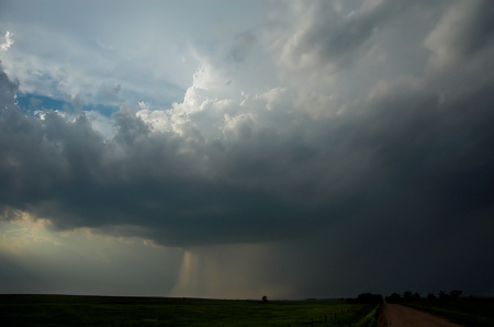
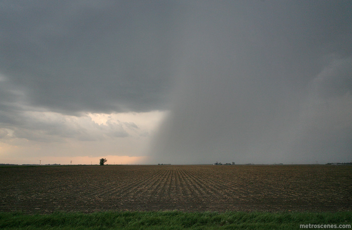
My experience pretty much echoes everyone else's. I chased C NE to NE NE, Burwell to US20/US81 intersection N of Norfolk, then down 81 to Norfolk as sunset approached. I saw some pretty cool updrafts ingesting quite a bit of scud a few times, but the stacked nature of the wind fields just didn't allow for anything truly discrete.

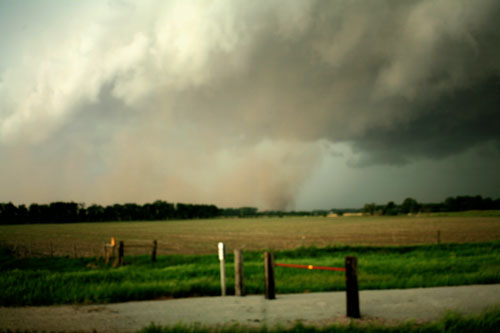
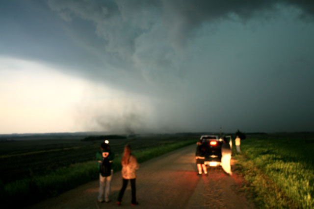
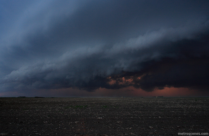
At day's end, I found a hill E of Norfolk and caught this (New photo technique...get your door frame between the lens and the sun to keep the sun from washing out the rest of the pic, LOL!):


(click for larger versions)

Bob
 
Jay, Stacie, and I targetted the area around Phillipsburg by mid-late afternoon where surface convergence appeared to be maximized. We tried to stay as far south as we could as it appeared most of Nebraska would erupt in too many storms. It turns out that indeed happened. The problem was, storms in our target area were developing out ahead of the boundary layer convergence or the remnant Pacific cold front itself. We monitored trends in radar and the sky, and it just wasn’t clear which storm was the best to intercept. Finally, around the town of Guide Rock, we stopped to let the atmosphere hopefully straighten itself out in hopes that a coherent severe storm could evolve.

We watched a small storm approach us from the southwest near Guide Rock both visually and on radar, which had up to 65 VIL at times. As the storm got closer, we could hear a faint hail roar. We continued east about 5 to 7 more miles to stay ahead of this marginally severe storm. We stopped a couple times east of Guide Rock to photograph the structure of the updraft of this storm, which was somewhat respectable. It appeared marginally supercellular-ish when it was between Guide Rock and Nelson…to the southeast of the main developing SVR line forming on the cold front. We went north on Hwy 14 and our storm became worse looking visually. We met up with Matt Crowther and Jim Leonard north of Nelson and continued east on Hwy 4.

The rest of the chase just sucked.. at least for me. Storms on the cold front began to get much better organized to our west-northwest. We decided to hang out for awhile at this location on Hwy 4 somewhere not too far west of Davenport. The light was getting low, so I decided to set the tripod up for photography. Inflow winds were gusting to about 30-40mph from the southeast… which was promising! I left my tripiod un-attended for about 20 to 30 seconds or so out of reach. You can guess what happened next. I don’t have my heavy duty Manfrotto tripod with me, but more of a lighter-weight landscape photographer’s tripod legs. Anyway, the tripod fell forward, lens-first onto the gravel road. I completely busted my 18-70mm lens. The body is okay, though thankfully. So that was about a $300 lapse in judgement not paying attention with very strong winds. It’s a good thing we are in a fairly decent sized city (and I have some supplemental cash) so I can replace this lens right away. I missed out on some decent low light structure shots as we were driving north on Hwy 81 in Southern Fillmore County…. oh well. It’s only Day 1….

_DSC3032.jpg
 
Once linear mode began to take over during late after, I figured that was it for torndo potential. However, we were caught by surprise after 2 well pronounced forward-flank mesos produced 1 tornado in Madison County, NE, and a second in Stanton County. The first near Meadow Grove started as a large plume of dust and appeared gustnado-ish, however, once some dust cleared and visibility was better, it was obviously a large dusty tube with at least a weak parent meso. Sirens were blaring in Meadow Grove as we blasted east, as the tornado raced north and dissipated.

Dusty tornado (low contrast)
Contrast enhanced to show tube from ground to cloud base

The second tornado developed near Pilger (Stanton County). As it moved quickly north of Hwy 275 we began driving east to our north option and an occluded meso with a smooth cone funnel hanging from it persisted for about 5 minutes as it raced away from us.

I'm currently in the process of getting video grabs to OAX, they were a bit pessimistic of the tornado report, espeically with all the reports of gustnadoes this day (understandable). The stills show an obvious tube from ground to cloud, and it was even more obvious in person. We did witness numerous strong gustnadoes as well, but are convinced there were 2 bona fide tornadoes.
 
i chased from Plainview NE all the way back to Wayne NE, heard some reports of tornadoes and from others accounts i see there were, i ended up stopping in Otoe Co at 3 am ;-) yes im very tired but i will post some digi pics and video stills when i get time later this evening.. i did see some gustnadoes.. and at one point i could of swore i was looking at a tornado, but after reviewing video it was a breif gustnado but had the characteristics of a weak tornado( ouskirts of Wayne NE) and one the way back it was a never ending rain show, i mean literally 2 hrs of staright rain, and lightning flashes and the occasional c2g hits.. a few let me know dont stick your head out the window while parked... pretty fun chase since its been quiet for a while... congrats to all who bagged the tornadoes. B)( VID CAPS LATER )


awesome2.jpg


awsome.jpg


pan1.jpg


pan2.jpg


pan3.jpg


Sorry if images are large something is screwy with this computer i had the size set to 267/200 so i apologize if they need to be resized ughh!
 
Wow! Incredible day! I saw 2 of the 3 tornadoes reported: too bad they were obvious gustnadoes. I do enjoy the company of all the chasers out in the field these days, but I don't care too much for the false tornado reports. There were very strong winds along the leading edge of parts of the squall line yesterday, and strong photogenic gustnadoes developed as a result, but no tornadoes.

Saw some nice lightning after dark from the back side of the line.

Simon
[/b]


Yeah, saw several gustnadoes in NE. Thanks Simon for pointing out a problem. It's amazing chasers can mistake a gustnado (along an outflow-dominated relatively high-based shelf cloud) for a tornado. I guess in a slow chase season, anything that rotates with dust gets some excited.

I would hope those that did observe the gustnadoes that were reported as "tornadoes" would have the courtesy to inform the local NWS so they don't go down in storm data. Just a thought...
 
5-23-2006-4393665.jpg


Near the KS/NE border about 40-50 miles south of Hastings

5-23-2006-4396747.jpg


I sat in Hastings with a few good chaser friends at Pete McConnell's house most of the afternoon, waiting for something to go up in the "southern" target area... We decided to eventually take off to the south of Hastings, and end up pulling over to watch this at-one-time crappy storm decide to make a nice appearance as it propgated eastward and strengthened -- and eventually gave us outflow winds of 60-70mph. It was pretty cool pulling over, and having like 20-30 other chasers eventually pull over to the same spot as well (many also friends)... Fun day!

High LCLs (as a result of extremely large dewpoint deficits and low boundary layer RH) thanks to the strong afternoon insolation mixing out our low-level moisture during the afternoon, and relatively-weak low-level shear played roles in screwing our convection over today, and eventually we saw an upscale-growth from weak multicellular convection to an organized large squall line.
 
I knew the “What is a tornado?â€￾ debate would start soon.

Glossary of Meteorology
Tornado -- 1. A violently rotating column of air, in contact with the ground, either pendant from a cumuliform cloud or underneath a cumuliform cloud, and often (but not always) visible as a funnel cloud.


“I have some anecdotal evidence that a gustnado can evolve into a true tornado [Dave Blanchard, personal communication], but such an evolution is almost certainly rare. Whereas some true tornadoes might initially resemble a gustnado at the start, I certainly would find it easy to deny gustnadoes (as I have defined them) the status of true tornadoes. Unfortunately, it may be hard to train folks to be able to distinguish them from other vortices occurring in conjunction with deep, moist convection. I certainly have encountered a lot of different notions about gustnadoes, even among meteorologists, much less the lay public. There seems to be a disturbing trend to refer to all tornadoes occurring on a gust front as "gustnadoes" whereas I have tried, apparently without success, to confine the term to the shallow vortices on gust fronts that seem not to extend as far as cloud base.â€￾ Charles A. Doswell III[/b]

Yesterday I observed numerous gustnadoes and two non-mesocyclone tornadoes in SE South Dakota. The first tornado was 5 miles NE of Tyndell, SD and lasted 14 minute.

2006_05_23_001.JPG


2006_05_23_002.JPG


<div align="center">VIDEO CLIP</div>

The second tornado occurred from 6:22 to 6:29 PM 3 miles SE of Menno, SD.

2006_05_23_003.JPG


Scott Currens
www.violentplains.com
 
We spent most of the day watching data and seeing tornado potential slowly dwindle. After a nice barbecue, we left my house in Hastings.We were 5 vehicles strong at that point, myself, Kurt Hulst, Nick Grillo, Dan Robinson and his crew, and a nice couple from Australia, Dave and Cindy. We shot east on highway 6 and then south a little. Long story short, everyone except me went south to set-up for tomorrow and I went north before going back to Hastings. I had a good view of some nice mammattus and good lightning. Brief strong winds as the line passed. At least the chase season is on again. :)
 
Began the day in North Platte. We had our hopes pinned on something more isolated toward the NE/KS border, perhaps south of Grand Island and points eastward. Upon reaching Grand Island, we played the waiting game while data-grabbing at the Holiday Inn Express. Met and chatted briefly with Mike H. and Jeff P. for the first time - nice guys, who'da thunkit? :p 
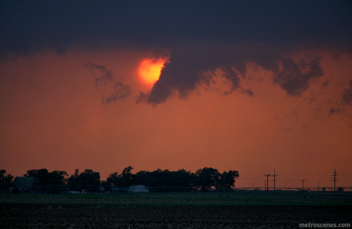
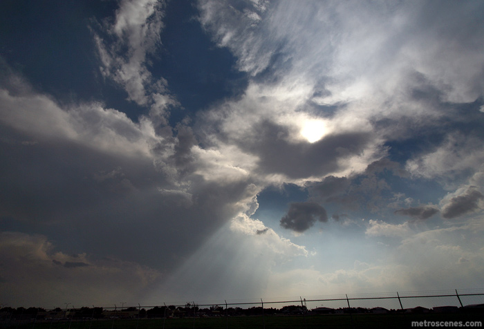
Unimpressed with the clusters going up in the northern watch area, we decided to keep our focus I80 southward as we waited for fellow hometown chaser Mike Robinett to reach us from Lincoln. Finally discrete cells began firing off ahead of the main line in northern KS with impressive-looking towers; gave us some hope. We migrated southeast through Clay Center and stopped south of Geneva to watch a cell collide with the line and allow the line to overtake us. Aside from some vigorous unorganized spin in the updraft overhead and the gorgeous sunset lighting, we didn't observe much. I'll post a pic or two when I am able to. Congrats to those who had some fun with the gusters.
 
Took of from Spencer, IA around 10 AM to head to Arlington, NE and pick up Dustin Wilcox. Arrived in Arlington around 1 PM and from there talked about what the game plan was going to be. Obviously we were going to have to move to the west, especially with the MD out barely reaching the NE/IA border. So we left Arlington, NE and went west to Columbus, NE where we arrived just around 2 PM, ended up sitting in COlumbus waiting for something to take control. We got word that the tail end charlie was at least doing something, possible wall cloud. We took off down 30 from Columbus towards Grand Island, NE. We ended up running into road construction and having to take a detour north of Central City, NE and once we came back into Central City were stopped by a train! This was all occurring between 7 PM and 7:30 near Central City, NE. From there we dropped south to get to the tail end of the MCS at that time, where a cell popped up in front of the line once again. This cell seems to be one of the more organized ones as it put down some decent hail and quite a bit of it as well as we punched through it. (Quarter sized hail, in two seperate sheets between Aurora and York, NE.) Once getting past York and ahead of the line we continued until the first option north which we decided to take and then stop to get pictures and some video of the pretty good shelf that had developed. We sat in between Utica and Waco for about 10 minutes, where we then decided to go north and stay just ahead of it, well this is where we ended up seeing the gustnado to our east and decided to follow that just a bit, gustnado occurred approx. 1 mile north of Utica, NE at and just after 8:30 PM. We were overtaken by the storm and ended up within some pretty intense stuff for a while, storm reports to go along with the storm indicate winds were up to 80 mph with some brief hail that we encountered. Visbilities within the storm were nothing, rain/wind combination along with the dust/leaves pretty much blinded you. Roads were not great at all either, with even paved roads covered in water.

Essentially that was the end of the chase, as we were the chasee by this storm and basically within it as we traveled back towards Arlington, NE. Some very intense lightning with the MCS, watched several lightpoles and towers get struck. Also saw some spectacular 'spider web' lightning towards the latter part of the drive. Arrived in Arlington just before 11 PM where I planned my trip back home, which ended up only going to my uncles in northeast Nebraska beings it was already after 1 am when I was at that point.

696.5 Total Miles
13 hrs, 58 min Road Time

I'll get pictures up on my website hopefully tonight or sometime tomorrow.
 
Went east from Mitchell on intiation to near Bryce where I was on the first severe warned cell. It was quite omnious with a very dark core and a partially obsecured updraft region which showed rapidly condensing scud moving up. A new cell formed in front of it and killed it off. This cell while as good on radar wasn't visually impressive. I spent the next 1 1/2 hours driving SE then NE to different cells on the line. At around 4:30 I noticed a huge wall of dirt being picked up, though it wasn't a gustnado or dry microburst but a truck driving on the dirt roads as the gust front caugh the air. As I headed NE back to Mitchell I observed six or seven gustnadoes each of varying degrees of size and strength. It's not suprising really as the winds had backed significantly and were 25-30kts towards the gust front! At 5mi west of Mitchell I noticed what looked to be a generally lowering of the cloud base (tilted downwards) and a very large column of dirt. The dirt/dust extended all the way to the cloud base so I did at least speculate it may have been more than environmental rotation of dirt kicked up by the outflow.

As I got into Mitchell I could see it better. It didn't appear to be violently rotating (enough to do any damage) but there was some general rotation and even more rising motion. I should also note the radar had a very strong rotation signature at around 8kft that extended above just a single tilt. The cloud feature that dips towards the surface is also pretty interesting as everyone who has posted a gustnado/tornado picture has had this.


Then I noticed a strengthning storm on the line approaching Tyndall, this storm seemed to bow out it's gradient a bit from the other cells near it. When I started coming up on the forward flank, it also had a tilt down cloud base that seemed to be the apex of the outflow.


Obviously a large force of wind coming down under here causing the dirt to become airborne which is reacting with strong SE winds. Directly behind it I witnessed several short but rather impressive gustnadoes.


I turned the car north, let it hit me and then drove inside the wall of dirt. It reminded me of pictures from the dust bowl, there were gustnadoes all over the place.


All in all a fun chase. I don't really consider any of them to qualify as tornadoes since there was never any significant rotation and since there was no damage it would be pretty hard to quantify.
 
I targetted the Neb-Kan. border area and sat in Concordia until storms started to build back down the dryline. I moved West and watched scronny towers go up along the dryline for a little while until it became clear that the day was going to be a bust. I called it a day at 6:30 and headed back to Wichita. It sucked.
 
Back
Top