5/23/06 REPORTS: SD / NE / KS

Joined
May 18, 2004
Messages
285
Location
Centennial, CO
I'll be curious to read other posts and thought I'd start off the report log. In a word: linear.

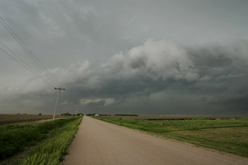
Left N Platte and headed into Valentine, Nebraska. Watched early elevated convection steal the show and move rapidly east. Chased the long line of cells spanning from SD down to KS and saw them congeal into a squall line with no discernable features. The propagation of the cells southward along the line was obvious based on a line of towers and weakish anvils in low contrast haze. The cold front was so intense that the scoured blue sky and western winds traveled with me eastward into O'Neil, NE. Despite being in the TOR watch box, being in tandem SVR warns, it was at best a lot of driving for rain. Nebraska rain. But, rain all the same. :)

I guess the things that really blew it today (pun intended) was the southerly winds with little convergence along the rapidly-moving front (would have loved a little more backing). Everything was sort of out-of-synch with the best thermodynamics separated from the best wind fields.

Switched over to "virtual chasing" by the time I got to O'Neil and watched as the tail-end charlie storms on the line got their inflow cutoff by prefrontal storms that had fired in N/C KS.

Hope someone got lucky out there!


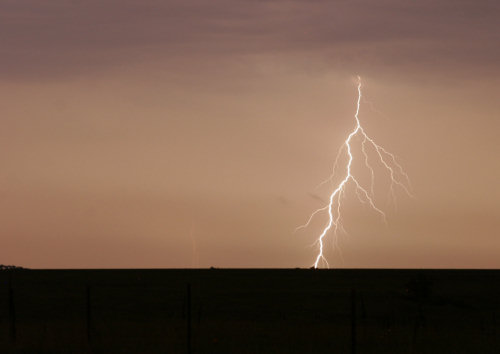
***Addendum noted by SPC log: From Union Cty SD at 0126z TORNADO THROWING UP LOTS OF DUST JUST EAST OF EXIT 38 ON INTERSTATE 29
Looks like a tornado could have used my medical services today (if only I could have seen some reprocity, eh?). LOL
 
Leaving work early paid off today - went SW of Mitchell. Gust fronts and dust were the main feature seen today...then it went into a gustnado fest. Lots of small ones - maybe 30-50 yards across spun up in fields. Got a big gustnado that seriously looked like a wedge. It was sucking up dust pretty high. Called it in to the NWS and they confirmed there was rotation. They went ahead and listed my report as a tornado, but I was really careful with my description to make sure they knew what I was looking at. It was kicking up dust and rotating. I was a little too close so I had to get out of the way before I could get some pictures. After doing some filming north of Yankton, I left a little later than I should have and got caught in the east edge of the gust front with a protusion on my south side. Saw some 2-3 inch branches get snapped off. Sped up and got out of it. On the way home, another small gustnado spun up and was probably 20-30 yards across and it went right across I-90. Will post the link to the blog entry and some pics here tomorrow.

Blog entry

5-23-06-13.JPG


5-23-06-22.JPG


5-23-06-31.JPG
 
A very long and frustrating chase. I was stuck with my flight arriving in Oklahoma City at 10:30PM Monday evening. My preliminary anaylsis suggested a Day 2 target of Grand Island. I had a long drive ahead. I made it to Salina before I was about ready to pass out. The next day, I checked data and shifted my target northward to southern South Dakota. There wasn't much time. I left Salina and blasted northward to York, then west on I-80 to Elm Creek. I was pleased with th southeast winds and dewpoints in the 60's. As I headed north on 183, a northsouth line of elevated convection formed from just west of Broken Bow, northward to the SD border. I had initially expected more isolated storms to form behind the line near Valentine but nothing much happened. I turned NW on 2, then drove to Dunning. At this point, it was clear that the line of elevated storms would be the storms of the day. I turned east on 91 and drove through the line. I hoped some of the storms would become more isolated. Just north of Bartlett, the storms seemed to be becoming more surface-based but still in a line. I drove east on 70, then south on 14 to target one of the storms. I saw rain and wind. Very unimpressive. I did see couple of gustnadoes in the outflow dust but I wouldn't get any video. In Madison, I turned south on 81 and was briefly ahead of the line. One storm to my southwest was showing impressive reflectivity and intermittant shear on XM. I stopped south of an area significant rotation (per XM) and noticed a brief change to inflow with significant southeasterly winds (7:40PM). I couldn't visualize any rotation. Soon, there was more cool outflow. I decided to bag the chase and go to Columbus for the night where I was treated to a nice lightning show.

temp052306severestorm1.jpg


Vid still: 7:41PM CDT Platte, CO NE from 81


Bill Hark
 
Just a quick note, as I want to get to bed, but here are some video grabs of what at the time was the Tail End Charlie, taken just wnw of Sutton, NE. The time stamp is still in standard time, not DST. I believe this was only a gustnado, because the storms were pretty much out flow dominate and going linear quickly. But a couple of the vid captures get you thinking for a moment, maybe wishful thinking.

2006 05 23 Sutton, NE - Gustnado
 
For my first chase, this wasn't a bust. Our target was Hastings, NE. We held off on the widespread stuff to the north until some discrete cells started firing ahead and south of the squall line. We intercepted a few elevated updrafts, and got rained on a few times. The backbuilding squall line's bases appeared to be lowering, and we were seeing some inflow features. We pulled over on the side of the road near Hebron to watch for lightning. As the sun set, the lightning increased rapidly, and there were more inflow features rising into the cloud bases. Dick McGowan, JR Henly and several other chases pulled over with us. Soon, a two tiered shelf cloud developed. and quickly brought severe wind gusts, and blowing dust. As we headed south toward Concordia, KS, we were treated to a spectacuar light show.
 
After spending the night in North Platte, we drove east on I-80. We stopped for lunch in Kearney, Nebraska, and looked at the latest data. Decided to push on east, and stopped further along in Grand Island. Storms were building to the north-west, and we expected these to back-build down the cold front/dryline through the afternoon and evening. We met up with Stu Robinson and the Silver Lining Tour group for a time.

A large chaser convergence seemed to be occurring at the truck stop where we were, but after a while most of them left (some following the Doppler on Wheels!). We stayed for a little while longer, but then decided to head west to the look at the developing storms.

We spent the remainder of the day investigating cells which popped ahead of the main band of storms. None of these individual storms seemed to be able to organise - a lack of low-level moisture/instability was probably the main reason. All the while, the line of storms along the cold front became stronger. After dog-legging south-east we ended up in Geneva, Nebraska. The line of storms was moving in rapidly from the west, with individual cells moving up the line from the south-west. We decided to let them pass over, and they did, with vigour! Winds increased dramatically - probably to 60-70mph at times. 15mm hail rattled against the car, as well as torrential rain - visibility went down to about 50 metres during the heaviest rain. At the same time, continuous cloud-ground lightning was occurring - at least 3 strikes were within a few hundred metres of the car, within about 1 minute!

The storms passed away to the east, and we decided to head to Lincoln, Nebraska, for the night.

A few pics on the website - URL below.
 
FULL MAY 23, 2006 CHASE LOG CAN BE FOUND HERE!

On a day where 2 new states were stepped in and a third state added to the 2006 chase list, our group of chasers scored well on a day which spoiled many chasers scattered across targets from the Dakotas into Kansas. Three tornadoes were reported in South Dakota on this day, one of which was reported twice in SPC's records, and another gustnado seen by us make at least the three. Verne and company picked up the day's last tornado on I-29 while heading south. Chris and I continued east on 90 into Minn to get further ahead of the advancing squall line which ultimately lead to us missing the day's biggest tornado.

Out gustnado was great, and while not technically a tornado, will go into the records as one. A strong circulation spun up southwest of Letcher as we took a well paved Bob's road as it crossed less than half a mile in front of us. That was the high point of the day which took me into a total of four states, starting from Nebraska and working our way through South Dakota, briefly stepping into the corner of Minnesota, then are last stop in Iowa where we bunked down for the night. We ran into Chris Collura off I-90 south of Kimball and he joined us for the trek through Dakota.

A wonderful third day to my trip with excellent close video of the gustnade which was spawned at the leading edge of the incoming line of storms. The video and stills are below.

FULL MAY 23, 2006 CHASE LOG CAN BE FOUND HERE!

060523i.jpg


http://www.youtube.com/watch?v=7o0Zma89cxg - Video of gustnado!

FULL MAY 23, 2006 CHASE LOG CAN BE FOUND HERE!
 
Kim Klockow and I started the day in York, NE, and headed west to Grand Island, where we met up with Mike Kruze and Geoff Fink and waited for several hours, hoping against hope for srn NE discrete supercells. Got fed up around 5 pm and blasted over to Wood River, where we watched as the line congealed. Raced out front and stopped ahead of a nice turbulent shelf for an hour or so, finally stopping in Aurora to let it overtake us at the truck stop off I-80. Observed a small gustnado in the field just across the street, and then enjoyed the view as the line raced overhead. Got some great mammatus and sunset shots shortly thereafter, and enjoyed the lightning show after dark.

All in all, a day that went from cautious optimism at 11 am, to pessimism at 4 pm, to a pleasant surprise at 8 pm. Just another chase day. :D
 
Chased in Nebraska today with Joe Nield (see his report above), Kim Klockow, and Geoff Fink. All four of us congregated at the Comfort Inn in Grand Island shortly before noon, and found a reliable wireless connection. We chose Grand Island because of its central location- there were good road options to go north, south, or west as needed. We also had not yet decided if we wanted to play the northern target in north-central NE and southern SD, or to remain in south-central NE. We had some debate on whether it was worth it to head to the northern target due to the more favorable upper level winds and earlier initiation. However once seeing how quickly the convection was becoming linear, we decided it wasn't worth the trip up US 281. We decided instead to wait for initiation farther south along the boundary, and held on to some glimmer of hope that there would be isolated cells to chase. Around 5 PM we left Grand Island and headed west to Wood River, where we intercepted several small cells that were well on their way to becoming linear.

01-earlyline.jpg


By 6 PM the squall line was well formed, and we began a process of racing ahead of the line, stopping to take pictures while it caught up to us, and then racing ahead again. All along the way we observed numerous plumes of dust blowing along the ground, all of it straight-line. We continued staying just ahead of the line until reaching Aurora, NE, where we stopped at the Love's/Arby's at the freeway exit. From the parking lot of Love's we observed a brief gustnado in the field east of SR 14.

We ate dinner at Arby's while the squall line passed over us. Through the window we observed reasonably strong winds (though nothing damaging, I would estimate 40-50 MPH) and heavy rain for several minutes.

The highlight of the day happened after the squall line moved through. There was quite a bit of clearing behind the line, and with the backbuilding anvil, there was a spectacular display of mammatus at sunset. We were standing on a county road a few miles south of Aurora surrounded by spectacular lightning to the east, colorful mammatus overhead, and the setting sun to the west. It absolutely made the chase day. As night fell, we continued east along I-80 and stopped east of York to take lightning photos. All in all it was a very successful day considering the convection we had to work with.

02-mammatus.jpg


03-lightning.jpg
 
Same report as Tony L except that Michael and I decided we would take the favorable I-29 south in front of the squall line and see what we could find. Just south of Bereford, SD in Union County 8:18pm CDT we drove right up on a large dusty tornado that developed right over the highway (where it tossed a 2000 gallon water tank). We pulled over and filmed it as it spun off to our east and then dissipated after 5 minutes or so and we were overtaken by the squall line. A nice little surprise non-supercellular tornado that seemed to have formed in the comma/forward bow of the squall-line. :)

>> Click here for full report <<

20060523_T1_sm.jpg

Developing tornado as seen looking southeast from I-29

20060523_T5_sm.jpg

Tornado at it's strongest, east of the interstate

20060523_T8_sm.jpg

Tornado about to dissipate and we are overtaken by the squall-line and we lose it in the rain!

>> Click here for full report <<
 
Watched the little cells struggle near Red Cloud NE all evening. Finally around 7 or so I figured I might as well go play with the line and find some photo ops(I hate going home empty handed and at 7 was well on my way). Got ahead of the line after getting in it somewhere east or se of Hastings. I kept thinking about the likely mammatus behind the line as well as the shelf structure ahead of it. The shelf was just too high based and I figured the view from behind the storms was likely to be more rewarding than the view ahead of them. So I flew back west at sunset hoping to clear the rain and have a view with some light left. Mid-way through I got a cool view of a shower ahead of the line from under the shelf. It was just cool looking as everything was orange and the shower's core was dark and falling ahead of this orange sky. Then it got windy. THEN I pull back on the highway and continue to fly west. It took a while but I finally got the view I was looking for. I have a lot of images from the night part but here are a few.

06-5-23-6086.jpg


06-5-23-6096.jpg


06-5-23-6121.jpg


06-5-23-6132.jpg


06-5-23-6138.jpg


A full account and all the images at some later date. Time for sleep now.
 
Whew, just got home (OUN)... Gabe, Dan, Brandon, and I headed towards the KS/NE border today (see NOW/FCST thread I suppose). We sat just west of Belleville and Mankato for much of the late afternoon and early evening, watching storms try to persist but ultimately do little. Several updrafts were relatively persistent, but they were, largely, quite small and moved northeastward into NE. We kept hoping that we'd get a good southern-end supercell, but we never really saw any supercell structure at all with any of the updrafts. Several of them had nice, nearly rock-hard towers from time-to-time, but they looked to pulse a little. By 7pm, it was obvious that it just wasn't going to happen.
 
I made the long haul to Concordia Kansas hoping for a tail end charlie scenario because I have been storm deprived for about 11 days and dont see much hope on the horizon for Western North Texas or Western Oklahoma so I chanced it and got burned. I guess I did get some decent photogenic scenes with towers developing West of Concordia and Salina areas as the sun set but nothing to get too excited about. Looks like the cap was very strong in this area and dryline didnt have a good push further to the South.
I was going to go back to Wichita Falls and be home about 3:30 am or ....now lol. Wouldnt ya know it tho i get one of the few remaining rooms in Edmond ( a PGA golf thing in town) because I didnt want to risk the sleepy eyes syndrome and now I have gotten my second wind lol. Luckily checkout here is noon. I will probabaly stick around the OKC or over towards the Tulsa area this afternoon in case the front decides to fire off and why not.... There doenst appear to be anything worth chasing on the plains after today till.....MAYBE.....Sunday (Friday maybe high based stuff) or Monday? Hopefully we can get some Isolated Texas Panhandle sups starting next week. I am hestitant to dismiss the Memorial weekend totally as it is historic for big outbreaks and surprises.
This was my first chase to Northern Kansas and The chase terrain as you all know im sure is amazing. Too bad there wasnt much to chase. I was surprised how green it is up there. When you get normal rainfall It seems to do wonders. Wheat crops look good as well. Big grainy heads about 5 inches. If no major wind or hail storms hit it should be a good harvest. The harvesters are jsut now getting into the Western North Texas area and will be working their way North im sure.
Anyways chase today was not too good as far as storms but it did kinda help the SDS. (Storm Deprivation Syndrome) for those few who dont know :p.
 
Our 12-member group of primarily Virginia and North Carolina meteorology students chased north from Grand Island into northeast Nebraska and southeast South Dakota. It was a grungy day that reminded us a lot of chasing back east, but we did manage to follow one cell with some weak rotation and something of a wall cloud north and east of Niobrara, Nebraska. We ended the day north of Vermillion, South Dakota, letting the squall line wallop us as we watched it approach beside a field. We also saw the dusty gustnado that moved nearby toward I-29 to the east.

Here's a shot of the nicely tiered shelf cloud approaching us on South Dakota 19 north of Vermillion.

sdshelfcloud.jpg


More on our trip in my weather blog at Roanoke.com.
 
Back
Top