4/24/06 REPORTS: KS/OK

Joined
Dec 8, 2003
Messages
1,526
Location
Grand Forks, ND
IMG_0065s.jpg


The super-de-duper short version: Went "full circle" to snag the El Reno, OK tornadoes. Pictures at:

http://www.convectionconnection.com/CHASE-042406/

The long version:

I had high hopes for 4/24 before going out... primarily because of decent BL moisture. While it may have been more prudent to prepare for my thesis defense which was successfully completed today, there was no possible way I could resist a backyard chase. Besides... I wanted to visually document a few more descending reflectivity cores ; )

In support of PHOTEX ( http://hal9000.metr.ou.edu/PHOTEX/ ), myself, Ben Baranowski, and Liz Stoppkotte left at approximately 1pm. I hoped to meet with my advisor who was awaiting the arrival of my other committee member from the airport around 2pm. Ideally, we would have met up in the field and worked on stereo videography of some supercells.

We initially targeted the outflow boundary in NC OK and headed west towards El Reno, then north to Enid. Along I-40, I passed my favorite billboard, the Buffalo burger sign. Little did I know I'd be getting a better view of this sign later in the evening. To make a long story short, the convection in NC OK looked like garbage from our stand point. Perhaps we benefited from not having detailed radar information. We didn't realize one of the storms had a decent mesocyclone. Serendipity at work! After a narrow brush with a ditch on a bad road option, we received word from our now caster that new convection was initiating along the dryline. Convinced our current storms weren't going to pan out, we raced south on I35 towards the Anadarko storm.

As we neared OKC, we decided to take the Kilpatrick turnpike along the NW side. While I am normally opposed to tolls, I can honestly say this choice was the best $2 I've ever spent chasing - it allowed us to intercept the soon to be El Reno supercell with only a few minutes of time to spare. As we were traveling towards I-40, the El Reno storm rapidly developed. The storm quickly acquired a large rain-free base and for the first time during the day, I felt like we may have been on a decent storm. Once we turned west onto I-40, the storm developed a ragged wall cloud. After a brief jaunt off the interstate, we settled near the overpass at Exit 132. This position offered a largely unobstructed viewpoint of the storm.

As the wall cloud became better defined, I dashed to setup the camcorder and acquire GPS/compass heading/pitch/roll data. As soon as this chore was finished, I pulled out the camera and started snagging stills.

http://ww2.convectionconnection.com:8080/C...mg_0018_std.jpg (0024Z)

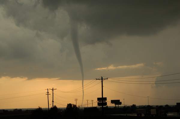
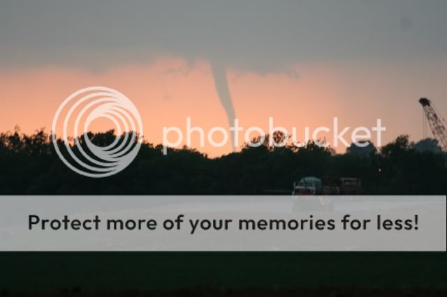
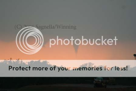
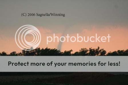
As luck would have it, the storm quickly became tornadic. A slender needle of condensation snaked down towards the surface...

http://ww2.convectionconnection.com:8080/C...mg_0023_std.jpg (0026:00Z)

For the next 14 minutes, I went into photographer fury mode. I rapidly changed lenses between my wide angle and telephoto in an attempt to grab a wide variety of shots. The first (and cyclonically rotating) tornado rapidly evolved from the original needle into a narrow-cone shape:

http://ww2.convectionconnection.com:8080/C...mg_0032_std.jpg (0027:24)

http://ww2.convectionconnection.com:8080/C...mg_0033_std.jpg (0027:48)

http://ww2.convectionconnection.com:8080/C...mg_0035_std.jpg (0028:18)

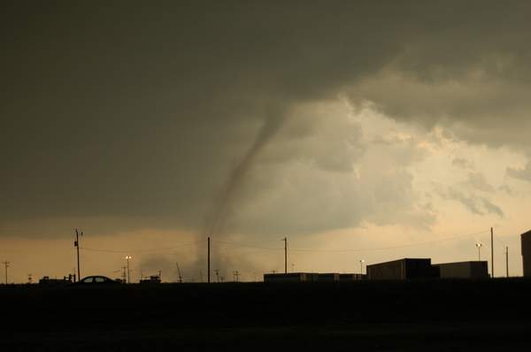
and then into a vertical rope:

http://ww2.convectionconnection.com:8080/C...mg_0036_std.jpg (0029:16)

wide angle shot:

http://ww2.convectionconnection.com:8080/C...mg_0040_std.jpg (0030:03)

The tornado started to tilt slightly, and then became somewhat translucent. At this point, we could finally see some debris (dirt):

http://ww2.convectionconnection.com:8080/C...mg_0043_std.jpg (0031:12)

The condensation then disappeared except for a few small filaments. While I thought the tornado was ending, it actually persisted for a while longer with the condensation reappearing on occasion in the form of a slender rope.

http://ww2.convectionconnection.com:8080/C...mg_0048_std.jpg (0032:07)

http://ww2.convectionconnection.com:8080/C...mg_0050_std.jpg (0032:19)

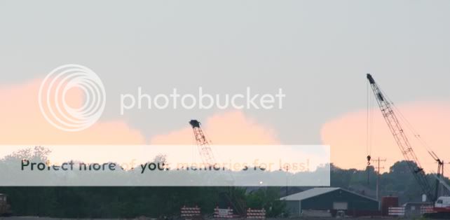
Around this time, the crowd of gatherers (all non-chasers at our location) started hollering about a second tornado:

http://ww2.convectionconnection.com:8080/C...mg_0053_std.jpg (0033:26)

While we were too far to discriminate which way it was rotating, it did appear to be in the proper location for an anticyclonic tornado. I didn't make that connection till a friend mentioned it later that night.

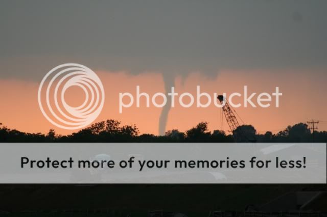
This tornado took on a rather landspoutish look with a largely translucent trunk accompanied by a large plume of dust near the ground:

http://ww2.convectionconnection.com:8080/C...mg_0057_std.jpg (0035:01)

While I thought the original tornado had dissipated completely, it in fact had not!

http://ww2.convectionconnection.com:8080/C...mg_0059_std.jpg (0035:51)

Wide angle:

http://ww2.convectionconnection.com:8080/C...mg_0060_std.jpg (0036:32)

A few last shots of the anticyclonic tornado:

http://ww2.convectionconnection.com:8080/C...mg_0066_std.jpg (0038:07)

http://ww2.convectionconnection.com:8080/C...mg_0067_std.jpg (0039:01)

A few remaining shots taken within Yukon, OK of the clouds during sunset:

http://ww2.convectionconnection.com:8080/C...mg_0070_std.jpg

http://ww2.convectionconnection.com:8080/C...mg_0080_std.jpg

http://ww2.convectionconnection.com:8080/C...mg_0083_std.jpg


Last remarks: From our viewpoint, the RFD appeared rain free. I managed to obtain the level II data from KTLX, and the first tornado had neither a substantial appendage or DRC associated with it. So much for a quick addition to my thesis defense!

Aaron
 
Was on the Perry storm early in the day. It was ok as it went down the toll road. I took the wrong exit to get on the toll road and had to drive back up the ramp. Evidently one doesn't make mistakes in OK and need back on where they got off of? Or did I miss the on ramp? It went to scary wet gravel and I sure didn't see an onramp anywhere. Perhaps there was one somewhere and I'll feel that much dumber learning I missed it. But anyway got back on I-35 without a problem and got on the toll road. I didn't know I couldn't get back off of it onto that n-s highway! It didn't matter but was frustrating messing with all that.

Near a lake to the east it seemed like it was gearing up to put one down but had that lovely crap from the south come up and ruin that fun. It really did appear it would do it. After that.....hell.....what a joke for an area to chase in! I zig zagged se to get ahead of the storm that went into Tulsa. I think it is safe to say I won't bother with ne OK again. The area I was in in April 03 wasn't terrible but the area today......jeez. It really sucked finally getting a tornado warning to your sw and having no real way to see it. I went east in its core into Tulsa getting no views of it(not because I was in the core, no, because of the stupid hills constantly blocking the view sw) until I got on the nw side of town. Then all I had was a the view from a walmart parking lot. It really did have some amazing structure as it came into town. Evidently it produced some baseball hail there. I guess I'd have to say this storm had the best structure I've seen yet this year...as it came into Tulsa and moved through. I think that was the first time I've chased a nice tornado warned supercell through a major city. It was a nice ending to an extremely frustrating chase.

Congrats on those that got the tubes. I'm pretty sure the Tulsa storm did not produce.
 
I chased with Gabe and others today... We sat in Kingfisher from about of hours this afternoon, watching storms develop near the OFB and cross into the cold outlfow near and east of I35. We were hoping somethign would develop west of Kingfisher and move eastward into the back flow near the OFB. Well, a few tried to go up after the initial round near 3pm, but these only acted to reinforce the cold pool. With only a very narrow axis of instability between the cold front / dryline and the cold outflow near I35 and the relative lack of sustained convection, we opted to drop southward towards a right-propagating supercell that was west of Anadarko. When we approached El Reno, radar was showing that the convection to the south was congealing into a quasi-linear mess, while another storm was exploding just southwest of El Reno. We sat just south of I40 for a while, watching the storm go from a flat cloud base to wallcloud to impressive RFD cut to tornado #1 to tornado #2... The position was nearly perfect, though we did have to shift south about half a mile in order to get some buildings out of the way. We followed this very slow-moving storm eastward after the first two tornadoes dissipated, but never really saw much else.

Overall, I am very pleased to have avenged the Oklahoma curse. I've really had very bad luck chasing in OK, so it was nice to get two very photogenic tornadoes. I haven't looked at my video, and I confused myself as to whether tornado #2 was anticyclonic or cyclonic... Since I accidentally left my camcorder on someone else's car as we got heavy wrap-around precip west of Yukon, I'm currently airing it out and crossing my fingers that it works. I'll have some pics up either later tonight or tomorrow. Yay to tornadoes within an hour of my apartment. The complete absense of precipitation in or near the RFD and tornadoes made the supercell look more LP than anything for a while.
 
Started the day in Enid with Jana Lesak and Mark Orther, then traveled south to Kingfisher in the late afternoon. Caught up with Jeff Synder and crew. Headed out to El Reno and saw that the storms near Lawton began turning SE, leaving the El Reno storm with undistrubed inflow air. The storm went from no ll rotation to rapidly rotating in 15 minutes, it was pretty cool.

tornado_elreno.JPG


Here is the anticyclonic tornado that caused the damage at the airport.

anticyclonic_tornado_elreno.JPG


More Pics here.
 
We were on the same storm as H. We basically found ourselves south of the intial development so we went for it. I was hoping there was enough instability east along the OFB through NC OK to sustain a tornadic threat but apparently that was a lost cause. By the time we realized we were getting undercut with cool stable air, we were too far gone to turn back. So, we stayed withour original storm from near Hennessy to Hominy, where we dropped it to focus on the cell moving down the turnpike towards Tulsa. We finally got around and in front of it as it went t-warned, and we thought we were in business. For about ten minutes it looked like we might be getting a tornado in OK's other major metropolitan area, but alas, after the first cycle the storm was done. Like H said, the structure was incredible, enough to make the day if you're a storm chaser. But I'm not.

Congrats to all who bagged the El Reno tornadoes. Those are some beaufitul pics Justin.

Aside: The TUL area FM radio spotters/reporters are a bunch of morons. Reporting wall clouds and funnels along a gusting out shelf. Jo and Chad (in a separate car) actually heard one guy say "Wall cloud but no lowering, funnel but no rotation." This one guy kept reporting a funnel for like five solid minutes. Mick and I were like "is it behind the mountain every time we look that way?" because we saw nothing. Then he reported "still winds" at his location (on the west side of the "rotation"). The guy was sitting on a windshift line on this very undercut, outflowish storm. It was spinning like a top in the mids, but as all our attempts all day, was being killed at the surface.
 
Argh. Left AR heading in the direction of Enid, OK. Stopped at my favorite Love's truck stop in Webbers Falls to check some data. I decided to continue west on I40, now targeting just west of OKC. I arrived at OKC just about the time storms starting churning along I35. Then I made the decision that turned the day into a little grungefest for me. I decided to follow the storm that was developing just N of OKC and marched it's way to Tulsa. I broke off that storm as it got closer to Tulsa because I didn't want to try and maneuver the roads through the city. Of course, the storm went Tornado warned as soon as it got to Tulsa. Haven't heard officially if it produced yet.

I dropped back down to I40 to make a decision to head back west toward my original target and catch anything that fired later, or head east back home. I decided to head home. I was monitoring WxWorx all the time and saw storms start to fire SW of OKC. I thought about turning around, but they started to line up and I just stayed the course and continued home.

I'm home now and I see that a storm produced near El Reno. Well I be dang.

I got impatient today and jumped on the southern storm of the line that fired around 3:00 CST. If I would've stayed my original course I would have some sweet pics. Ha ha, if, if, if. :)

Congrats to all that caught a tube today!!
 
Started in El Reno at 230pm. I had the same thoughts as many others about playing east of surface low near boundary, hoping for storms to cross into the "sweet spot" and do their thing. Still, I kept my eyes open to SW OK, where there was more instability, but concerned about less shear.

Headed N on U.S. 81 to witness storms moving perpendicular across boundary into stable air, and never get rooted in the boundary. Always high based. Headed deeper into cool air on Hwy 51 E past Stillwater. Supercell there (and one in Noble County) apparently tapping boundary layer air - but very cool. Decided against punching into back of supercell when noticed new echoes heading into Caddo County. I didn't want to chase any more cool and wet HPs in the trees and hills.

As I neared OKC again, new storm went up SW of El Reno. I figured that I didn't want to drive another hour to the Caddo storm, and the northern storm near El Reno had a better chance at better shear, and was well separated from the south. Drove straight west on I-40, and set up on the exit 2 miles west of Hwy 81, and started shooting the developing low-level meso. It tightened, and produced the first tornado starting about 4 miles to my west and moving straight toward me. The tornado was mainly a very slender tube.

DSC_0031_600pix.JPG


I believe the tornado lasted about 15 minutes, with the final few minutes being very "dental flossy". During the first tornado, a second tornado developed about 3-4 miles to its SSW along the flank.

DSC_0038_600pix.JPG


It appeared "spoutish", and was in the classic position to be the anticyclonic pair. Sure enough, it was. It moved over the hangars at El Reno Muni Airport, and the OKC tv stations got excellent chopper video up close. Storm remained a tornado threat for about 20 more minutes after dissipation, and then the storm died suddenly just after sunset. Got many pix and video (will have to watch to get the tornado times).

Will be headed out to survey the damage from both tornadoes on Tuesday, and will be testing out the new EF scale.
 
saw the El Reno tornado go through the airport ON TV at my apt here in Norman. Only reason I didnt bust out after it was due to the stuff to my SW. I feared that once I left Norman for another cell, that it would be the day Norman goest torn warned and I just dont want miss the day when that happens. Also the cells SW were still somewhat discrete and were encountering surface winds that were what I classify as significantly backed and I also figured that hell, if the El Reno storm could produce, whos to say that any of those to my SW couldnt go. So I ran out of my apt to first catch the storm coming into Norman. Then as I got to the Highway 9W & I35 intersection, I heard Gary over the radio mention that Stephens Co. in and around the Duncan/Rush Springs area had gone tornado warned and was showing some noticeable rotation on radar. So I took Highway 9 to Blanchard then 76 south toward Dibble. Well by this time of course, it was waay dark out and I was totally relying on my spotter back in Norman to keep me updated (Im dreading the roaming charges I racked up today YIKES, Im going to hear it from Home)(BTW, I ow him a beer). Anyways I couldnt go any further than Dibble b/c south of there, there were no E-W road options and Id be stuck core punching so I had to sit and wait for the storm to push of the road. But when it finally did I took after it toward Lindsey. My guy back in Norman told me about rotation over the of Purdy that heard off the TV so I headed in that direction. By the time I got to Lindsay, he said that they were saying there was weak rotation over the town of Antioch, which is not far from Lindsay at all (I had the DeLorme with me). So from Lindsey I headed east on 19 toward Pauls Valley. As I did I got somewhere in the pitch black of nothingess and farm fields in the vicinity of Maysville (which I never saw) and got where I could see out in all directions for a ways what was going on and the cloud features. I say this cause the lightning on storm was at-will and blinding. Never did I see anything that resembled a wall cloud, lowering, or any type of mesocyclone feature. Didnt see Jack. I do know that once I did get into Pauls Valley the sky opened up like its always seemed to do to me this year when I wind up in Pauls Valley and I got hit intermittently with pea sized hail. So like I did last month Pauls Valley, I was left to search for cover. Thankfully I got under the cover of the Valero fillin station right off the interstate. By this time I was like, alright, whats going on here. So I called up OUN and asked them. Basically what I got was that the storm wasnt overly impressive but still did have a meso. So by that time I was whipped wanted to get back to my apt, so i called it night.

Now having gotten back to my apt andhaving looked at the radar loop over the time of my chase, I am very impressed with the signature on that storm as I traversed from Lindsay to Pauls Valley. It was a lot better organzied than I thought and was actually nicely hooked at times. I wish I knew this when I was chasing. Woulda given me a lot better idea as to what I was dealing with. But overall, im not disappointed at all. Today in my opinion was an average to marginal type day in terms of tornadic setup. Even with all the OFB in Northern Oklahoma, I personally would rather skip those and chase something in southern and SW Oklahoma just a personal preference I will always have. So congrats to those that bagged todays gem. I know in my heart that there will be MUCH better days in the future as far as risk of tornadoes and overall setup. Today was just "blah, whatever". Anyways, im happy to have at least seen it on TV.


Currently Listening to: "45" -Shinedown
 
Started off the chase on highway 412 just west of I-35 about 10 miles. Watched storms build on radar in the vicinity of Enid and stayed put until they got closer. Chased the storm that was north of the Perry area. Saw several lowerings, but no funnels and I wasnt able to get close enough to see any good rotation. Roads in this area were horrible. Not only were there no road options east most of the time, but the old dirt roads that run east and west appeared to be trails in the middle of cow pastures. A storm came up from the south and sandwiched us between two storms so we had to head back west. Saw golf ball sized hail scattered on the ground somewhere to the north of Perry and got hit with some of it, but never for too long. Ditched this storm to position on the storm east of Stillwater that eventually made it to Tulsa where we ended the chase. Finally made it to Cushing on highway 33 southeast of Stillwater and saw brief lowering for the next hour or so, but nothing really too impressive until the storm got to the west of Tulsa. Here it had very good structure and looked like it was going to produce. But just like highway 33 southeast of Stillwater road option were not very good at all (never seemed to be any options east so it was hard to head north to catch storms.) Pretty frustrating day but oh well. I am sure there will be better days down the road. Bad road option, washboard dirt roads, and low visibility from trees and hills hampered much of the day. Did see several wall clouds so I cant complain. Thanks to Tyler Costantini for nowcasting for me today. Also, congrats. to those that caught the El Reno tornados. I have seen the pics. and they look awesome!

Chris
 
Image00006.jpg


Finally updated my website for this date. It was very frustrating because I was unable to get any stills from my digital camera, and ended up having to use video grabs. So sorry for the quality but it gives you an idea.

http://www.tornadoxtreme.com/2006_Chases/A...pril_24_06.html

For those of you interested in this crazy as usual chase read on.

My Dad had been in the hospital in Abilene so I was delayed. I had been looking earlier in the day to get up toward Enid or so. Really I wanted to be central Ok, preferably north of an E/W line through OKC. Models were indicating IMO that some of the upper level winds would be difficult to find further south I believe it was 300's or 250 plus sfc wind wasn't supposed to be too strong. Anyway dynamics on the northern end. My Dad got out (everything ok) after noon or so, and by the time I checked what was up and left Abilene, Tx it was a bit after 2:00. Plan was to shoot north up through Wichita Falls to at least Chickasha. I keep thinking of La Nina and previous climatology. I've had this weird thought for sometime that OKC might get hit by F4 or F5 somewhere between April 26th and May 7th. Probably silly but it had me considering getting close to OKC this day. However that was not to be. As I raced north early activity near Ponca City had moved off to Tulsa with associated warnings. I was thinking perhaps that was the show. Regardless I continued toward Chichasha passing through Lawton. About that time cells began forming along a N/S line to my west. I debated southern cell versus northern cell. For awhile south looked best and would be easy to catch, but then the north cell took on good supercellular radar characteristics. I decided north and would have to break though a minor core as I was headed north of Marlow on Hwy 81. I got up to Marlow I believe and pulled over for a stop. Checking radar it appeared my north cell was starting to finally merge with the more southern activity which had also had a couple of mergers. I figured chase over. However I did note an interesting cell up toward OKC - near El Reno (hehe). I would have liked to get it but appeared too far and I was tired. Decided to blow it off and head south. Along the way I checked out the wallcloud of a cell west of Sunray. Didn't look like much.

I continued on and noted the southern cell never merged. It had more of a right moving aspect, and as I approached hwy 70 intersect Threatnet was showing increasing rotation. I was debating the quickest way home and part of the shortcut was to head for hwy 281. The best way to do that was take hwy 79 and turn south at Petrolia. Lo and behold my cell to the west is looking more interesting so I figure the diversion is worth taking a look at the wallcloud even though it is getting late. The wallcloud isn't that far away, and hail appears to be a potential issue so I am a bit reluctant to take a small unknown backroad. I figure the cell is moving slow though and I can escape easily back east. I take FM-171 from Byers at 8:20 CDT. As I do so and finally break out from initial construction, trees and lower windy roads suddenly the wallcloud has some 'thingies' hanging down. Next it forms a small dark cone funnel just below the wallcloud. I continue to race west toward it. Suddenly I understand that I may not get skunked after all. It looks like I'm about to score! Sure enough the darn thing drops all the way close to the ground. I stop and try and shoot a digital still quickly while on the move just to prove I saw something - because - well you know the recent story. The camera was giving me fits. I continue on after the tornado is on the ground and headed apparently in my direction albeit somewhat slowly (20mph). Next to get closer and find a clear area to shoot a picture I have to drive a few miles down the road with large trees blocking my view while I can still see the upper part of the wallcloud menacing from above. My asthma had been acting up earlier and it was going bonkers now from the excitement. It is a weird feeling knowing you are approaching a nearby tornado on the ground but can't see it to know how close it is.

I finally got to a clearing and pulled over to shoot this incredible tornado at about 8:31 pm CDT. It was just beautiful and had that lonely menacing look as well. It was to my WNW about probably 3 to 4 miles. There I am trying to shoot pictures of this tornado and I'm thinking it's going to dissipate any second with no pictures. I keep trying to shoot and the camera won't focus cause it's too dark. I try and snap it off and it won't because it isn't in focus. I finally get a shot or two off. Next I try and call the NWS to report it using my Streetatlas overlay and the OUN number. I couldn't get the cell to call for awhile. I get the camera up again and finally figure out that the lens is set to AF (autofocus) which I normally only use for non-tornado things. I switch to manual and manually attempt focusing. I screw that up too, but get some shots off. Damn I'm anxious! Asthma getting much worse. I finally grab the camcorder and put it on it and record seconds of the tornado. At least it seems to be able to take a picture for a change! Arrrggghhhh!!!!! Yes, this is how I felt multiplied by 100. I hardly got to watch the tornado. It seemed to be getting closer and rain wrapped and getting dark. In the dark it is sometimes tough to judge tornado distances so I decided to bail. I had gotten more than I bargained for. I shot back east on 171 at 8:34. As locals passed in their vehicles I tried to honk, flash my lights, and stop a few and tell them what was ahead. I passed a family outside their house with the kids then backed up and talked to them. They didn't know the storm behind them had a tornado in it. The lady let me use her cell phone to call the NWS line. I promptly got in and listened to the somewhat long voice mail options of 4 current conditions and forecast and 5 talk to someone 8 to 5 during normal business hours. No way to log a report. (See other thread). I told them to look out and drove on back to Byers. There I took a position southwest of town on hwy 79 at 8:50 and videotaped the continuance of a possibly larger version of the tornado until 9:17 (see pics on website).

For one reason or another this was probably one of my most anxious chases. Not sure why but I think the asthma made it that way. Tough to chase when you can't breath well and feel rushed to call in a report and try and get some decent pictures before it gets dark, the tornado lifts, or runs over you. Quite a bit of quick annoying multitasking there. All that said this was also a very rewarding chase and a surprise after I thought I was going home empty handed. As you can tell from the pictures this was also a very healthy, interesting tornado to watch. My biggest regret is that I didn't really have time to enjoy what I found and watch it leisurely for awhile, plus all the photography to remember this event was mostly screwed up. I spent a lot of hours today just trying to get the marginal pics I got.
 
Caught the tornadoes near El Reno with Jeff Snyder, Justin Walker, and crew. Not much to add except that the southern tornado was undoubtedly anticyclonic. I had the rare experience of being in a tornado videography quandary (i.e. which tornado should I shoot?). LOL. This storm was easily one of the most photogenic I have ever seen. Only the Mulvane tornado holds a candle to the aesthetic appeal of this event.

My chase summary and pictures.

Gabe
 
[attachmentid=201]
Got one northeast of Burkburnett, Tx. Intense chase / wicked torn. Still in the field - more later.
[/b]


Very cool Bill! I am glad someone was on the Randlett Oklahoma sup. I hear the tornado was visible right along I-44 near the Casino. From what I heard it was a large white 200 yard wide tornado that roped out nicely.

My chase report is very similiar to Gregs. I also followed the cells North of OKC towards Stillwater then decided the head back to Wichita Falls and hope I might intercept something along dryline on the way home. About South of Moore I noticed the main updraft on the Ele Reno cell shooting straight up and hoped over on Hwy 9 then over to Hwy 4 and then up to I-40. I wasnt as close as Greg but I took mainly video of the two tornadoes and decided to shoot instead of try getting closer and missing the whole show.
Im interested in seeing what the Randlett cell looked like Bill. It had a great hook on radar and I have some grlevel 3 radar scans saved of that cell from my nowcaster if ya want to email me and ill forward them to ya. [email protected]
Ill have the website updated with this chase by Thursday. http://www.texhomastormchasers.com
 
Try to keep this brief as I'm beat...but felt like finally posting a report on here.

Start out this morning out near Weatherford, playing the middle. After burning some time eating and just looking at things online, the first cell finally went up near Fairview. After a few minutes of watching, felt it was a pretty decent bet the outflow boundary would go up. Headed out towards Watonga and then Kingfisher. Played in the middle of the batches of storms, but they never got their act together. Things started looking better, on the middle storm of the cluster, closer to Perry - but it wasn't meant to be. After having gone through chasing Osage County before, said heck with it and headed back south. At this time the dryline started to show signs of life.

Arrived back in OKC around 630pm or so, and noticed that the storm near El Reno was hanging around by itself, but it really wasn't the most intense of them all. Played the gut card on sticking with the one that could keep away from the other "kids" on the playground. Head into El Reno on I-40 and got off at US 81 and watched the wall cloud beginning to take shape. Following along on GR3 on how close the hail core was, decided to just find some shelter - just in case - but also got a great view due west into the area of rotation. Eventually saw what most people did, the evolution into the pretty nice tornado on the western part of El Reno - thankfully it sounds like it was mostly out in the open. After that tornado eventually spun itself out, circulation started to redevelop closer to our location - decided it would probably be good to leave. Heading south on 81 a bit and saw the funnel for the second tornado. After finally getting into the clear, got a pretty good shot of a very impressive (photographically anyway) tornado off to the west. Watched that tornado eventually spin out, though it appeared to go pretty far southeast as a dust swirl was observed by us not to far from US81 it seemed.

Decided to finally call it a day and make it back to Norman, but had a slow voyage back thanks to the congestion on I-40 and the periodic need to pull off to avoid driving into the hail core. All in all, not to bad of a day at all...from what seemed like a day going down as another bust to one of the best chases this season thus far.

All pics here...http://www.usaflying.com/blogs/photos/user...tegory1018.aspx
 
Chased with Tommy Winning and got not only my first tornado today, but my second as well! Started the day trying to catch up with the Kingfisher stuff, then decided to head back to Norman to prepare for new development along the dryline. Left Norman again at around 630ish, heading west on HWY 9 deciding whether or not to try to beat the hail core from the southern storm across I-44, or trying our luck with the developing thunderstorm to our north in Canadian County. We picked the northern storm and boy did it pay off. We north and jogged west, while we approached the base of the budding supercell and could clearly see a wall cloud develop and begin rotating. A funnel formed within about 5 minutes and touched down a minute or so later. This tornado was the largest, and looked quite menacing as it reached its maturity.

060424_wall_crop.jpg


060424_tornado1_1zoom.jpg


060424_tornado1_copy.jpg


060424_tornado1_3small.jpg


060424_tornado1_4small.jpg


condensation no longer reaching ground.
060424_tornado2_copy.jpg


Tornado #1 roping out.
060424_tornado3_zoom.jpg


Wispy little funnel.
060424_tornado4_copu.jpg


classic anticyclonic tornado (#2) touched down several minutes before tornado #1 dissipated.
060424_tornado5_copu.jpg


Nice mammatus tonight too!
060424_mammatus.jpg


EDIT: What we thought was a short-lived third tornado now appears to have been the last stages of the first tornado's ropeout.
 
I went out with Robin Tanamachi and Howie Bluestein, and we met up with Jeff Snyder, Gabe Garfield and crew and headed up toward Kingfisher as storms first started going up and crossing the outflow boundary. Seeing the fast storm motions and junky nature to the convection, which was likely elevated over the cool air north of the outflow boundary, we elected to stay back in Kingfisher county and wait on convection to form either at the dryline/front-outflow boundary intersection, or further south along the dryline. When convection started to fire in SW OK, we waffled for a bit, and then finally decided to head south after the intense cell that was then moving into Caddo county (around 6:30 p.m. or so). By the time we drove through the forward flank of the developing El Reno storm, it was becoming clear that it was by far the best storm in regards to discreteness and separation, so instead of heading toward our target of the Caddo County storm, we stayed on the El Reno storm. It initially looked as if the storm would merge with the Caddo County storm to the south, since the updraft base was pretty strung out N-S at first, but then the storm to the south took a hard right turn, increasing the separation between it and the El Reno storm. About this time, the updraft base really began to tighten up and take on very classic structure. We stopped on Highway 81 just south of 40, and the rest is history. We saw the full life cycles of both tornadoes, and personally that was the most rapid rotation I've seen on a wall cloud. The storm appeared to slow down almost to a stop during the tornadic phase, and then resume an eastward motion afterwards before dissipating, but I'll need to review the radar loop, as it could have just been the fact that from our vantage point the storm was moving directly toward us, making movement hard to judge. All in all, a very successful chase, made all the sweeter by it's close proximity to home!
 
Back
Top