4/24/06 REPORTS: KS/OK

Well yesterday I was very lucky. Chased up north all day yesterday. as the storms moved east of I-35 I head back home to Tuttle, OK. Saw the big storm over SW of Chickasaw on Radar and another smaller storm but more isolated sw of El Reno. Not beleiving the storm could ever tornado, I went to take a look at it as it was on not to far out of the way on my way home. Saw one anti-cyclonic on the south end close to I-40 and another cyclonic on the north end. Here pics of both.
 
Congrats to all who got the El Reno tors.

Walt Gish and I arrived in Alva, OK shortly after noon. It was obvious that we were N of the outflow boundary but I thought I would wait a bit to see how things developed, thinking that a move further S would be needed eventually. Ended up getting lulled to sleep a bit by the issued Tor Watch which put us near the middle of the western edge.

Has started moving toward Enid when the first storm popped SE of Cherokee. Took a look at it, but it was relatively high-based and was not in a good position with more stuff going up in a short line SSW of Enid. Briefly contemplated chasing the end of that short line, but in the end wandered down 81 to Kingfisher watching the struggling towering Cu along the way. As we sat in Kingfisher, a storm started to go up on the Kiowa-Caddo Co line and we began the journey to intercept it.

As we neared Chickasha, the area between the Cotton Co storm and the Caddo storm filled in quickly. Had noted the developing storm SW of El Reno on the way S, but ignored it since it was developing under the blowoff of the Caddo storm and so I believed it would be modified enough not to produce. Well, I was wrong, obviously!

After sampling the hail in the Caddo storm near Anadarko, we turned north and East back toward El Reno and on the way heard the spotters describing the developing tor. Fortunately we were already close enough to see it, but not in any position to get good video. Eventually set up a couple of miles S of I-40 on Barber Rd as the storm moved ESE. Some decent rotation, but no more tors.

Maybe next time....I'll beat this Oklahoma drought yet. Oklahoma tors tease me...but no good video yet. B)
 
Left OUN with Kevin Manross and a couple others and headed north toward Fariview, then east to Enid to get near the outflow boundary. Played around with the initial development near Enid, but let it move off into the jungles and the colder air east of I-35.

We headed back south toward OKC to get near the better backed flow, then eventually took off down the turnpike toward the new development near Chickasha. Near Verden, we climbed out of the river valley and watched the storm for a little while as it dropped hail near Anadarko. As we watched, we saw the Channel 4 chopper screaming northward above us. I guess I know why now!

The storm soon merged into a line with the stuff from the south. A quick check of radar showed the Canadian County storm to our north, but we figured that it would merge with the rest of them too. So we headed to the Chickasha Mazzio's for dinner.

Oh goodness. After placing our order, we saw the rotating wall cloud on the TV at Mazzio's. Then the tornado touched down. And it was pretty.

The frustration was enhanced by a group of screaming kids at the restaurant. At least we got a good lightning show on the way home. And, wouldn't you know it...the streets in Norman were pretty dry.

A pic of the Anadarko storm:

04240602.jpg


JB
 
My chase report is identical to Jeff and Gabe's, as I was enroute with them in a different vehicle throughout the entire chase. Therefore, I won't be redundant and post the details other than we initially drove to Kingfisher, decided to head south (initially targeting the storm near Chickasha), but then noticed that the El Reno storm was becoming more discreet and more impressive on radar and decided to pull off of 81 just south of I-40 to watch it. Ended up seeing both El Reno tornados. Thanks to everyone who was with us for making the chase very enjoyable.

Pics:

April24_1.jpg


April24_2.jpg


April24_8.jpg


April24_10.jpg
 
Mike Magsig and I barely caught the El Reno tornadoes from a 10 mi to the ENE vantage point in the forward core. Why?

We followed a storm south of Stillwater as curiosity got the better of us when we saw a distinct meso on radar. Getting 7 mi E and 4 mi S of Stillwater on Rt 108, we saw the embedded circulation as it tightened enough for the radar to see another gate-2-gate couplet. It was a rotating V-shaped lowering totally surrounded by rain. It looked good for awhile and then spun down without tightening further. We hung around a bit for that storm before heading down the turnpike for the western storms.

Our second intercept was originally intended for the Anadarko storm. However as we continued southwest on I-44, that storm started stringing out and a new cell popped up to its north. Mike and I liked its isolated nature and we continued into the city intending to intercept. Our mistake happened when we thought the storm would continue to the northeast for awhile longer and in response we took the dreaded NW expressway. It was no expressway and our error cost us a closeup encounter with the tornado. My stress escalated when Daphne's former REU helper, Lance Maxwell, called with an excited play by play of a rapidly rotating wall cloud and a forming funnel. It was too soon, and we were just a bit out of position.

Well, we got a view through the rain but it was enough contrast to see the motions and I can't complain.

The storm continued to move east occasionally spawning wall clouds but as Rich said, the cold inflow wasn't helping. Interesting thing about this storm afterwards was the occasional dumping of hailstones well into its inflow. We stopped in places that would normally be dry relative to the updraft and visual core. This time, I got beaned by a stray golfball. At least that's the size of the red spot on my arm.

I believe had we not gone after the Stillwater storm, we too would've been down in Chickasha with that storm. Had I an all day meeting (all too common), I would've left at 5pm and probably wound up on the Chickasha storm. I couldn't imagine not seeing what the storm in Stillwater was like. Patient waiting is just not my attribute.

regards,

Jim
 
I left Norman at appx 2:30 PM with two other freshmen, Bryan Salsieder and Kristina Kelley. We headed up to Kingfisher, then Hennessey before deciding to admit cluelessness and meet up with Brandon Lawson back in Kingfisher. He was with Melissa Moon and they were following Gabe Garfield and several others, a few of whom have posted above, so I won't rehash any of that. A big thank you to Gabe, Jeff, and all the other more experienced chasers for putting up with another car tagging along. I'm sure glad we did.

Here are a few shots of the El Reno tornadoes from about a mile south of I-40 on US-81 (same position as the others' shots). A complete set can be found here:

http://s25.photobucket.com/albums/c58/bret...Reno%20Tornado/
 
06-4-24-5706.jpg

06-4-24-5708.jpg

Supercell near Sooner Lake ne of Perry. It was becoming more discrete at this point just west of the lake and appeared to be organizing very quickly. I shot mostly video as it approached as I was messing around with the darn view so much. There were few places to pull over and large powerlines running along the west side of the highway. I got on that road but quickly backed my rear wheel drive car back off of it. I'm getting hailed on a bit at this time too. It wasn't very still photography friendly at this point. It get smacked by the southern convection as it gets to my location.


The next two are of the second supercell as it moves into west Tulsa. It was torando warned at this time. Radio reported baseballs in this area. I went east ahead of it through the city but couldn't view much of it as I did so. There were some wicked cgs coming down. One hit about a block behind me on the interstate.
06-4-24-5719.jpg

06-4-24-5726.jpg


I'll have to get some video onto the computer and do the whole account yet but figured I'd toss these up.
 
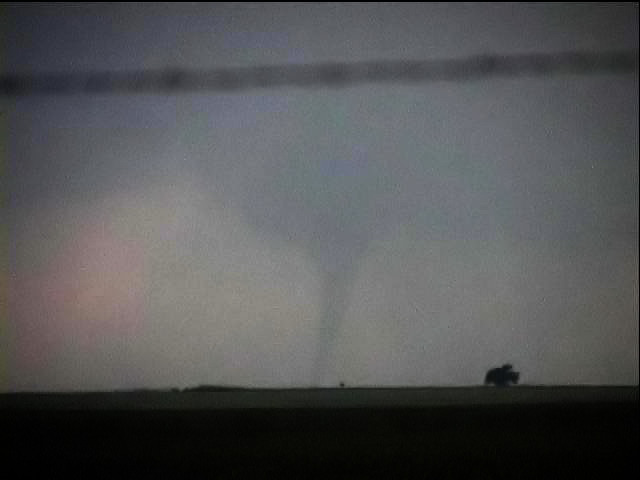
Well I didnt see the El Reno storm, even though I was sitting in El Reno for a majority of the day. I figured, well there are two possibilities: 1) Early initiation due to OFB over N-Central OK and 2) Dryline initation, probably later, over west-central OK. I ended up being too impatient and got sucked into the NC OK storms, which ended up going east of I-35 into the jungle and the cold pool. I got back to Yukon around 6pm, tried getting Wifi at the Best Western and it just didnt happen. I noticed the intensifying cell to the west, and the cell to the SW (which would end up flooding Chikasha). I figured the storm to the west (which would drop the naders over El Reno) would lose its fuel due to the storms to the south, so I took 4 south, scooted a tad west to 92 and took that to 62 and finally into Chikasha. Hauled butt south on 81 to beat the core and base. Just about that time the great song I was listening to was interrupted by reports of a tornado touchdown in a wheat field south of I-40.

At this point I seriously contemplated making it north to that storm. But I decided against it for 3 reasons:
1) I would have to drive through the core of the Chikasha storm to get there.
2) It would take me almost an hour to get there, and by that time:
3) The storm would be over OKC leading to about the worst chase conditions ever. I figured traffic would be stopped everywhere, and not to mention city chasing? Meh.
So I called it a night and followed the cells back, which mysteriously missed Norman. :)

All in all, an obviously frustrating chase. Sitting in El Reno until about 1, getting grabbed into the NC OK storms which were obviously not going to do nothing now that I looked at the obs (they were moving right into the cold pool, and bad chase terrain!) So yea, I blame myself for most of it. But, I think picking the Chikasha was not bad decision making just one of those gut instincts which was wrong in this case. Still, not a failure, the Chikasha storm was nice as pics above show. In reality the nice OFB was not so 'nice' as it was a teaser more than anything else. It did produce some nice convection, but the storm movement put them into the cold pool, not paralleling it.
 
2006april24grab10adjust_filtered.jpg

tornado southeast of Randlett, Oklahoma ~0133z shot from ~6 miles east, looking due west

More images on my blog.

Tail-end Charlie produced a tornado south-southeast of Randlett, Oklahoma in Cotton County I observed between 0130z and 0140z. Other chasers and spotters who were closer report this tornado as having lasted a full twenty minutes. The tornado began as a tapered funnel and grew into a fully-condensed elephant trunk before growing into a wedge, reportedly two hundred yards wide. This tornado was just north of the Red River according to spotters closer than I was.

After teaching today, I checked data and saw that the dryline was pronounced over southwestern Oklahoma and northwestern Texas. I preferred the area north of the river because dewpoint depressions were significantly lower, owing apparently to congestus earlier in the day, I was told. Either way, the 90F surface temp at SPS was not nearly as attractive as the more common low 80s over southwestern and south central OK west of I-35. Winds were backed and there seemed enough low level shear to offer the chance of rotating storms should individual cells organize. I was aware of the problems with anvil level flow and thought perhaps the earlier stages of any storm’s lifespan might hold more promise for tornadoes than later.

I drove north to Ardmore and turned west on State Road 70 toward the tail-end convection, which around that time (~2330z) was multicellular and unimpressive. While the cells organized and split twice and generally struggled, I noticed another storm to my north approaching Lawton with a pronounced hook. It was fifteen miles away and too tempting to ignore. I headed north and sacrificed my excellent position but realized within five minutes the classic stupidity of what I was doing and turned back south, now a little further east, to cast my lot with the southernmost storm after all. This bit of wizardry probably cost me a view that some spotters described as a "tall white" tornado. At the very least, it forced me to play the storm from a half-dozen miles away which yielded the lower-contrast, distant images I brought home.

Today I was thinking how ironic it was that I drove to Kansas on Saturday, chased all day Sunday, arrived home in time for a few hours sleep before work, taught school, and then with five minutes forecasting and preparation, raced out the door to my first real tornado of 2006 in a target chosen by time and space constraints.

Another note: it's been so long between Oklahoma tubes that I had forgotten the outstanding professionalism of spotters and Skywarn networks in Oklahoma. These guys are succinct, smart, and relatively bold with their positioning. The net controllers are coolly efficient in the way they collect and disseminate information. Not only is it immensely helpful to listen to the linked repeaters in Oklahoma, but it's about the best weather programming on any radio or television anywhere.
 
4.24.06.4.JPG

4.24.06.8.jpg

4.24.06.15.jpg

Same tornadoes everyone else got.....
Jumped on the early cells near the outflow boundary and eventually headed southwest.
Outflow boundary was just too strong; within a few miles I would measure temps of 65 or 75 deg F!
 
Sorry for posting this one so late but been having a time trying to figure out a way to post pics or links and a place to host them but I finally decided to use a sevice I have had for about a year and didn't know.

Anyway, on that wonderful monday that produced that nice event in El Reno that I missed, I came across a nice storm in Comanche county. I was orginally heading for the storm that was approaching Anadarko before it started to merge with ohter storms and loose it's hook on radar. From that point on me and my 2 chase partners decided to head on highway 16 to meet up with highway 65 south in Comanche county. We were watching another storm that became seprated from the genral line when it started to show what looked like a bit of a hook on radar. We headed for highway 7 east/west. After making a small pit stop at the Fina Station located at the inter section when I noticed what looked like the beginings of a wall cloud forming on the storm. I was orgianally going to head towards Duncan but decided to listen to my gut and head west to take a peek at this storm. That is when the wall cloud formed quickly about 3 miles west of the highway 7 and 65 intersection. We stayed with the storm from highway 7 all the way till it eventually got rain wrapped over Marlow in Stephens county and also becamed tornado warned. Due to the sunsetting and the defroster malfunctioning on the car and not able to see we called it off on account of to dangerous to continue on with out being able to see well, but I got some nice pics I want to share with everyone. I will post them in the order they were taken so you can kind of see it's evolution.

http://f3.yahoofs.com/users/41748b68z4fe89...hY3nVEBHvZ2CUXa
http://f3.yahoofs.com/users/41748b68z4fe89...pg?phY3nVEBVZsj
http://f3.yahoofs.com/users/41748b68z4fe89...hY3nVEBDK424v6m
http://f3.yahoofs.com/users/41748b68z4fe89...hY3nVEBCrSc5Ote
http://f3.yahoofs.com/users/41748b68z4fe89...hY3nVEB3C17CLcH
http://f3.yahoofs.com/users/41748b68z4fe89...hY3nVEB_mPUUMsh
http://f3.yahoofs.com/users/41748b68z4fe89...hY3nVEBM.6TlYq8
http://f3.yahoofs.com/users/41748b68z4fe89...hY3nVEBvmuY1pgb
http://f3.yahoofs.com/users/41748b68z4fe89...hY3nVEBACPTTjdR
http://f3.yahoofs.com/users/41748b68z4fe89...hY3nVEBV_LtW9vm
http://f3.yahoofs.com/users/41748b68z4fe89...hY3nVEB2.0DQtHw
http://f3.yahoofs.com/users/41748b68z4fe89...hAHoVEB9s.0xXB3
http://f3.yahoofs.com/users/41748b68z4fe89...hAHoVEBahvVaVTu
http://f3.yahoofs.com/users/41748b68z4fe89...hAHoVEBC10FdsUA
http://f3.yahoofs.com/users/41748b68z4fe89...hAHoVEBz1_cm50d
http://f3.yahoofs.com/users/41748b68z4fe89...hAHoVEBgHXoEKo6
http://f3.yahoofs.com/users/41748b68z4fe89...hAHoVEBRnkJZrNL
http://f3.yahoofs.com/users/41748b68z4fe89...hAHoVEBFdx0pc5u
http://f3.yahoofs.com/users/41748b68z4fe89...hAHoVEBEiUgNpBt
 
Back
Top