• While Stormtrack has discontinued its hosting of SpotterNetwork support on the forums, keep in mind that support for SpotterNetwork issues is available by emailing [email protected].

4/13/26 KS Tornado Event Article

Joined
Jun 17, 2007
Messages
406
Location
SIlver Spring MD

I find this article promoting misleading/false information for several reasons. I am verbose below, but is not a 1-2-3 subject/issue. I'm sure Mike Smith and Randy Zipser will have some things to say!

1) The title, "we are missing data." Vague and generic clickbait. Data is always missing here and there for any number of reasons. No quantification, just "data" so the implication is that it is a lot or serious. Also, just b/c some data is missing, does not mean it automatically translates into a problem worth talking about.

2) The MSM gets all up in arms when tornado warnings are not issued. Now they harp on no tornado watches? A significant number of tornadoes occur when no watch is in effect. Watches have definition -- a certain coverage and duration criteria expected that needs to be met. One tornadic supercell, no matter what it ends up doing, does not mean a watch is/was required. Anyone ever hear of "mesoscale accidents?" Also, what is more important overall in saving lives?, the warnings, not the watches.

3) Concerning mesoscale accidents, they happen at times. Just the limit of the forecast science. It is no one's "fault," but the MSM acts like missing tornadoes should *never* happen. 8/24/2016, the event in IN/OH -- 22 tornadoes and quite a surprise. Who or what was to blame then? They can't resist looking for blame/fault. Sometimes, there is none.
Storm Prediction Center 20160824's Storm Reports

Also, if these KS tornadoes were in the middle of nowhere w/ no societal impact, this would not even be a story. Cherry-picking is going on here. Look at the Campo CO surprise event on 5/31/2010. Can you imagine if that supercell formed over or very close a city or larger town? But it only made headlines in the severe wx/chaser community.

4) This idea that RAOBs missing makes or breaks things is becoming outdated. There is much more data available in real-time now updating far more often than RAOBs. ACARS for instance. GOES mesoscale sectors can send us imagery up to every 30 seconds. NOAA20 and 21 provide NUCAPS soundings twice a day over the entire CONUS in-between 00 and 12z RAOBs times, and so on. These fill a big gap in data. So we are far from "missing (or inadequate) data" overall.

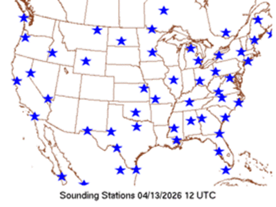
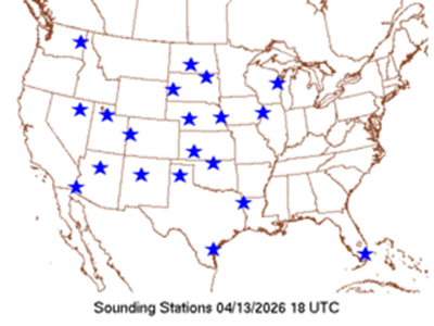
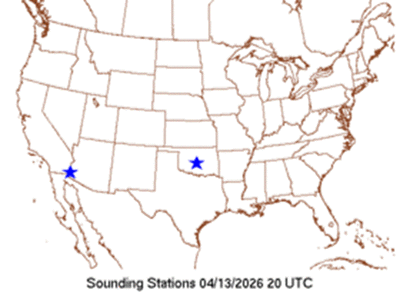
5) It talks about how RAOB times have shifted. Ok, so the data is not really missing, just done at a different time (18z instead of 12z). And I would argue that 18z is a better time in the day for the CONUS as it is closer to max heating and convective initiation, and we now have most models running at 18z initialization time now. I attached maps of the available soundings at 12z and 18z for 4/13. Just upstream of the tornado event, you had a number of RAOBs at 18z and an OUN RAOB at 20z. The first KS tornado was not until 00z. So how much of issue is there of this time shifting or RAOBs really? Who’s to say in this case concerning mesoscale phenomena, no 12z RAOBs hurt this forecast overall? You have more recent data at 18z closer to the event.

6) Can one definitely say or determine that the RAOB change times resulted in no tornado watch issued? The burden of proof is on the ppl or organization making the accusations or raising questions, not the other way around. Model data is just one of many, many things that go into a forecast, severe wx or otherwise. To treat it or imply it is a simple 1-1 correlation in this case is ridiculous

7) And finally, I find this article a thinly veiled excuse to bring in politics and blame the current administration for this "problem."


This all can be viewed as case of the MSM stirring the pot for merely content and agenda, making more of an issue than it is really is, omitting key facts about the nature of forecast science, and oversimplifying a complex situation.
 

Attachments

  • sndgmap.gif
    sndgmap.gif
    73.6 KB · Views: 0
  • sndgmap1.gif
    sndgmap1.gif
    65.6 KB · Views: 0
  • sndgmap2.gif
    sndgmap2.gif
    58.4 KB · Views: 0
And finally, I find this article a thinly veiled excuse to bring in politics and blame the current administration for this "problem."


This all can be viewed as case of the MSM stirring the pot for merely content and agenda, making more of an issue than it is really is, omitting key facts about the nature of forecast science, and oversimplifying a complex situation.
As always, Boris, a great post for further discussion! But, there's a lot to "unpack" here.

I agree that "blanket" assertions like the NBC article insinuates would not necessarily apply to any one specific situation, let alone some systemic "problem" with current upper-air data collection methods.

Like many mainstream-media (MSM) articles, the purpose of the issuers is to cater to a very short-term news cycle event, like, for example, a big tornado outbreak...which can then be used to bring to the public's attention some "problem" which now has to be addressed with a sense of urgency. The MSM knows that the public's attention span is very short: that's why they try to "strike while the poker's hot" and magnify the level of remedial urgency by publishing a story like this. So, naturally, a story like this will gloss over facts that are deemed to be irrelevant in order to reach some desired conclusion to support a particular view, motivate a particular public action, or to drive some "political" agenda. This is nothing new; however, the MSM must work harder nowadays to push the narrative because people are overwhelmed with so much information daily that their views may not be as widely seen as in the distant past, when only three major news outlets existed.

Speaking of the current administration, to be fair and coldly objective, the foray into meddling with areas of science which have always been non-political in nature heretofore (thinking of DOGE, for example), has certainly not helped to advance their natural evolution and progress. [Admins, this statement is not intended to be inflammatory, just a purely objective observation.]

Lastly, if one seeks factual information about anything happening in the field of meteorology, the place to seek it (rather than MSM or social-media outlets) is to keep up with AMS recognized publication sources or similar peer-reviewed professional periodicals or newsletters. A lot of this information can be found online, so no paid membership is required. And, thankfully, ST is always a great place to find open discussions like this...
 
Last edited:
Here are my thoughts. Thank you for inviting them, Boris.

If it would have been impossible to make an accurate forecast without the 12Z raobs, then this forecast would have been impossible https://stormtrack.org/threads/2026-04-13-event-ok-ks-mo-ia-mn-wi.33369/ (first entry) along with the accurate forecast on my blog the next day. Like many of us ancient meteorologists, I don't rely solely on models. There was a lot of pattern recognition in that forecast backed up by using the SPC "events" feature.

What bothers me more than the "no severe" forecast for east central Kansas Monday (even on the 3p outlook) was the no thunder forecast in SPC's first two outlooks for the 13th. I can't imagine what they were looking at that led them to conclude there wasn't even a 10% of a thunderstorm over the area. I have wondered if that avalanche of CAM's has done more harm than good. I do know that tornado forecasts have not improved in accuracy the past decade.

At many of the meteorology colleges today, forecasting is an afterthought and NOAA doesn't do nearly enough training to make up for that deficit. At WeatherData, Inc. and then AccuWeather Enterprise Solutions we had a four week training program for new storm warning meteorologists with multiple written tests plus OJT. You had to pass all of that before you could ever issue a storm warning (solo) for a client. From what I have heard from multiple NWS meteorologists is there are WFO's that are not nearly as rigorous before allowing mets to work the warning desk.

SPC forecast a "moderate" risk of severe thunderstorms and tornadoes the day of the Greensburg Tornado and the day before. The models leading up to that event were not obvious. I fear that today we would be seeing, at most, "slight" because the CAM's might not be able to handle it.
 
I'd say the occasional overperforming springtime dryline event in the Great Plains is normal and even to be expected. There have been many big events that only began to become obviously-so by mid-morning. At least that was my reason for not chasing the days like Katie/Wynnewood/Sulphur that looked too marginal to even stay out on a chase trip the day before even though I was already there! Then, halfway home at 10am the day-of, I'm looking at visible satellite and kicking myself for not staying an extra day. May 3, 1999 was also like that (though that was before my time in the Plains). Then we have the inverse when volatile-looking days bust completely.

Our ability to reliably nail all of these just doesn't exist yet.
 
In another thread (can't remember exactly which one), there was quite a bit of discussion about forecasting paralysis/confusion among chasers by looking at too many CAMS, not all of which are that great. This certainly relates to some of my own experiences the last season or two. The discussion in that thread seems to relate to what Mike says above. If it is confusing to chasers, I would think it could be confusing to NWS meteorologists, too, especially with the apparently inadequate training going on now.
 
Back
Top