• While Stormtrack has discontinued its hosting of SpotterNetwork support on the forums, keep in mind that support for SpotterNetwork issues is available by emailing [email protected].

4/13/07 REPORTS: TX / OK / AR

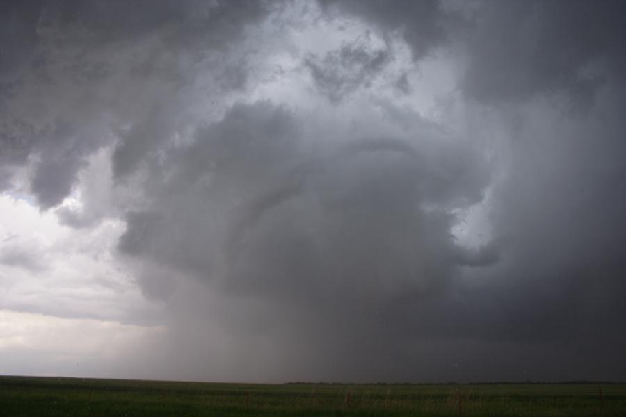
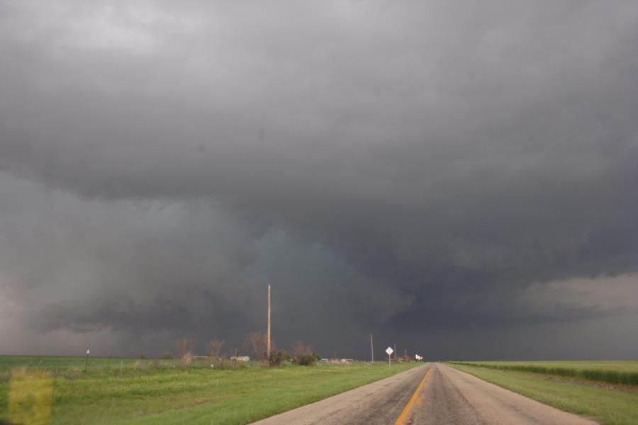
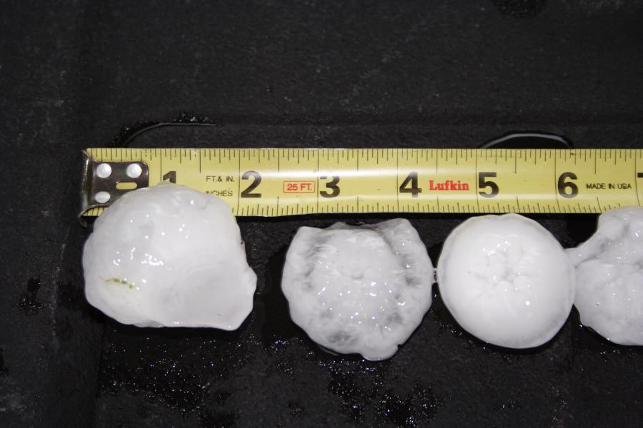
TARGET: SEYMOUR, TX TIME OF DEPARTURE: 10 AM. Jim Deguara and I left Dallas right on time and headed west on Rt. 380. At Throckmorton, we broke out into the warmer air and had a decision to make whether to head to Seymour or continue west toward the dryline boundary. Then, two Cb's came into view to our west. Thinking that we needed to maximize the thin ribbon of the warm sector, we picked the southern cell and continued west toward Haskell. We seemed confident of this decision when a tornado warning was issued for western Haskell County. Angling northwest on Rt. 222, we arrived at Weinert on Rt. 277 in time to see the rain free base approach from the southwest. The base was relatively high and went through an occlusion right on Rt. 277. We headed east then north to near Goree. South of Goree, we saw the original updraft shrink and produce a long serpentine funnel. A new circulation (more violent) began south of Goree and continued toward Seymour. Unfortunately, the core of baseball hail was right over Rt. 277 and we had to back track to Throckmorton before turning north toward the storm. That decision/time cost us the wedge south of Seymour but saved our vehicle. We followed the storm northeast as it crossed the boundary at Archer City, then dropped southeast to Fort Worth. By then, a squall line developed and headed toward us. As we approached Fort Worth, we could see a shelf cloud to our west and sought refuge under a carport in Saginaw. There, we got 2 inch hail. We were quite surprised to find out that a tornado formed to our east-southeast in Haltom City. Oh well, two swings and two strikes for us today. TM
 
IMG_0004_1__0001-1.jpg


elevated convection was occuring with the warm front draped out along the mid-south...there were some severe cells in the area with some marginal hail threat, but the biggest threat was cloud-to-ground lightning...which really was a good relief to any SDS that lingered after the winter...

IMG_0001_0001.jpg


they had purple/blue bolts with those golden "streamers" i guess youd call em...you know, the sparks that remain after the lightning disapears...its been lightninging all night and its 511AM now...woke up to see the stratified line come in with a major cloud-to-cloud show...
 
Witnessed a tornado develop and stay on the ground for ~2-2.5 minutes on the SW side of Fort Worth at ~5:55pm, Link below:
http://www.stormgasm.com/4-13-07/4-13-07.htm
homepagepic.JPG


Target was Olney, TX: left Norman at 9am sat in Olney for a while, saw storm develop in Haskell County, but decided to let it go, because I thought the it would either cross the warm front quickly or get undercut by the pacific front; wrong, so I opted to intercep any new storm development near Throckmorton. Then the Haskell Co. Storm gets tornado warned, so I book it to Seymour; watched insane rotation and possibly got a peak at the tornado as wet RFD plowed the road in front of me. After storm got out of the way I stopped and took some pics of 2+inch hail on the ground in Seymour. Drove ESE to hit developing storms, which formed a line and pretty much gave up on the day south of Mineral Wells.

Then I got very, very, very lucky: I decided to attempt to get ahead of the monster squall-line and took I-20 east instead of just heading north on state routes, which would have been quicker. So I accidently miss my exit for I-30 and end up stuck on I-20, but when I was driving onto the I-820 loop onramp from I-20 and witnessed this:

The arc cloud from the gust front in my location went from 'slanted' to 'vertical' with a very convective appearence instead of a 'whale's mouth'. Also, the scud along the leading edge of the gust front dissapeared and the gust front developed into a relatively flat base at that location. As I was driving under the gust front and onto the onramp for I-820 I witnessed the formation of a gustnado (or so I thought) to my south out my passenger window. It was very impressive and I almost didn't stop, but I wanted to get some more pics for the day so I pulled over on the shoulder of the ramp (nobody was behind me).

I slowly pulled out the video camera, because the gustnado situation didn't seem imminent, but as the gustnado moved into view of my front windshield I could see an obvious 'in-my-face bowl funnel' rapidly rotating above the debris cloud!!! The camera was still not on, but I had to get out of the car and see it with my own eyes to confirm it was actually a tornado and not just a look-alike-gustnado, but surely enough it was a bowl funnel all by itself with a nice debris cloud!!! I got the camera on just as I was getting back in the car and rain was now starting to pound me, because the base/gustfront was moving away from me and I was then behind it again. I saw large debris being lofted into the air as the tornado passed over some buildings, and I had by friend Tom on speaker phone and yelled for him to report it to the NWS in Ft. Worth. That was the last call I could make from my cell until I left the DFW area that evening.

I'm irritated I missed the Seymore tornado in my target region, because I had no intention of chasing near DFW yesterday, but I got dumb luck and got a tornado in Metro Ft. Worth.
 
Rocky Rascovich and I departed Norman, OK (KOUN) at 1730z, a bit too late to reach the Seymour, TX tornadic supercell. We got as close as Nocona, TX before deciding the storm would be elevated junk before we could intercept it between Wichita Falls and Archer City. So we dropped south in hopes of new storms ahead of the developing squall line.

My fears of hodograph loop/kinks due to cold-air advection (CAA) in the 1.5 - 4 km layer came to fruition as these new storms were rather poorly organized multicells that quickly evolved into a squall line as a north-south oriented radar fine line (apparent cold front) undercut everything. The best we saw was heavy rain and 20-30mph winds in Weatherford, TX. Structure wasn't good due to low clouds, haze, and trees except for a few minute view of a shelf cloud before it hit us. The entire event appeared to be a hopeless linear squall line so we decided to end the chase and eat dinner at the Cotton Patch Cafe in Weatherford.

Of course, the squall line broke up along the warm front to form the classic tornadic supercell which struck the DFW Metroplex. However, I'm not too fond of chasing a metro area during Friday rush hour, and this event wasn't that spectacular, so no big loss.

In retrospect, the proper strategy was to chase the early storms as they crossed the warm front over northwest Texas before the CAA/hodograph/squall line problems began.

SPC MCD issued April 13 at 1951z:
mcd0481.gif


Congratulations to those who found the needle. We were buried by the haystack. At least in the internet age, we get to see your pictures and video.

One of the days I'm finally going to learn to simply blow off these hodograph kink/loop squall line events altogether. :D
 
Last edited by a moderator:
was also on the Seymour storm - heres my report

Entered Semour from the west on 114 around 1:15 , stopped for gas
while enroute to Semour we noticed the system building above us through haze...at vera around 1:00 there a a slight cloudbreak and warming started. We continued to our Semour target and arrived there still in some pretty good haze. Seeking more convertive heat I felt a south shot to Throckmortin might be a good idea. On arriving there about 2:15 I noticed a rapidly building system off to my North..explosive. By now it seemed that all the storms started to fire at once. Knowing of no immediate way to run back there in time and knowing of the iminent hail threat. (as it turns out alot of people got hail damage there)
Next I proceeded west 5 miles out the 380 from Throckmortin made a north bound 1 mile run to a gated road where I witnessed what I believe was maybe the end of Haskell storm/tube at about 2:30 - 2:45. Too far away to really get a good video grab we decided to get on a cell that developed directly in front of us!
We bolted back to Throckmorton and picked up this building cell going n/e hwy79 out toward elbert. Ended getting under a large funell that was producing big dust swirls directly on the ground. Just prior to getting out my wife shot 2 impressive shots one directly into the lowering funell which produced a perfect round image, amazing. Scary amazing. Then it was "gogoggo" to get out.
We then hit a detour and booked it down to Grahm where we decided to call it a day.
Great day, better pics on the 4/12 littlefield, but no real complaints. Congrats Tony!
 
school bus "chase"

I teach in Mineral Wells and drive a bus. I had been able to peek on the net during the day and was aware of the moderate then High Risk the SPC had out for our area. I also had been monitoring the vis satellite and radar so was a little apprehensive as school let out and I began my route.

It had been grey-cloudy all day north of the warm front but as I walked out to my bus the skies were a bright and soupy as low scud flew on a very stiff southeast wind. Warm front seemed to have passed.

After I loaded the kids at my school, I had four more schools to stop at. As I drove around town I kept checking toward the west and southwest skies but the bright scuddy air prevented me from getting a clear view. From radar I saw before I left I knew there were cells entering the county to the west but I couldn't see them. Driving an assigned route, aboard a large, high profile vehicle through crowded traffic and having 50 children on board, well it gives the usually routine trip an edge anticipating what could happen.

I pick up at the last school on the east side and as I drive through town there is still no clear view to the west. I make my first drop on the west edge of town and head out about 2 miles into the country.

I begin to see the edges of towers through little gaps in the scud to my far southwest. When I drop off at the first houses in the country the scud is gone and I can see a dark wall to the west. At my last stop near the Brazos river the anvils stream overhead and far to the east into the first blue sky we had seen all day.

Now it's just my daughter and I as we hurry back home to Mineral Wells. We beat the storm to the house and soon get some pretty good gusts and marble size hail and are tornado warned by NWS Ft. Worth.
I enjoy severe weather but I would rather not go out welcoming it to town in a loaded school bus.
 
Good day, but could have been better. After just about deciding not to go out I left Tulsa area around 10:15 in the morning. Headed to Wichita Falls and then from there took Hwy 82/277 toward Seymour area to intercept the storm.

I was a little later than I wanted and found myself out of position to continue to take 82/277 in order to beat the storm to a good south location. I briefly contemplated trying to beat the storm to the south option (cannot remember the road I was trying to reach) and quickly realized that I was going to have to core punch or backtrack and try to find another option.

The threat of baseball size hail quickly diminished any sense of valor and I backtracked and began to become annoyed when mile after mile passed without any south option. (I cannot believe the terrible road networks in that area). Anyway, eventually found some rural road (sorry I did not save my GPS file so I am unsure of the road--stupid huh) and was almost due south of the storm.

Noticing the incredible inflow into the storm and the roar I could tell that there was a violent tornado in there somewhere. Thank goodness Amos, Tony and crew had position, because I was really interested to see what was occurring.

I am disappointed about not having better position to view the tornado, but the small snippet of video includes some of the best audio that I have ever had of a tornado. The "squealing" sound came out pretty well and I have included a link to some video (bottom of post -- the second and third portions of the video clip are of the storm trying to get it's act together again between Seymour and Archer City.) http://www.yousendit.com/download/QlVqa3NkR0ZCSWMwTVE9PQ


I continued to follow the storm and after repositioning myself I got in better position and the rotation again increased and I thought that another tornado might drop. Did not occur at that time and finally took one last shot close to Archer City, but by then the line was really filling in and I headed east.

Stayed with some of the line for awhile, but got disgusted with the linear nature of the storm and decided to call it quits. Wish now I would have stayed with the cell that plunged ahead of the line and dropped the tornado on Ft. Worth, but I did not really think that much more was going to happen and I wanted to avoid the Metroplex at all costs.

Overall, I had mixed feelings. I was certainly glad to be close to the action at Seymour, but definitely disappointed about missing out on the visual of the wedge. (I really, really hate the road networks -- or lack thereof -- in this region)!


Link to video: http://youtube.com/watch?v=RIOJ_XdPG9I
 
I caught up to the Ft. Worth/Dallas supercell as it produced a large wall cloud right of the Dallas metroplex, and followed it to dark. Not a bad chase considering the event did not pan out at all like I expected.

My girlfriend and I left Houston at 10am for Hillsboro, TX. My target region was southwest of Fort Worth near the Stephenville area, but I figured Hillsboro would be a good place to find data. As my luck would have it we were not able to find a wifi connection and headed to Glen Rose by 2:30pm.

At that time things are still looking great for supercells to fire to my west in the next couple hours. I repositioned further north in Granbury. By around 4pm I made it to the Granbury library and saw that the cold front had continued to surge faster than models indicated, and a squall line was developing. By 5pm I basically gave up and started heading home.

Heading northat on state highway 67 to 35W Simon Brewer called me up and told me he had just witnessed a tornado on the west side of Fort Worth from the "bow echo" storm. Apparently it was becoming surface based again. I immediately called a friend for nowcasting help. Upon reaching 35W I stayed northeast on 67 and headed for I-20.

We got just a few miles south of downtown Dallas and saw a large wall cloud to our north hanging over the metroplex. We were listening to the reporters on the radio flipping out. We headed east on I-20, punched through the southern edge of the hook and turned northeast on state highway 34 through the town of terrel.

Heading northeast on 34 we were east of the hp supercell. We were never able to get northeast of it, so all we could see was a very long and ominous looking RFD gust front and the meso occlusion that disapeared into the rain. But WOW the low level clouds were soaring into the storm very quickly. We headed east upon reaching Quinlan and it got dark. The storm was producing a strobe light of lightning.

We drove in and out of a squall line all the way back to Houston (east on I-20, southeast on 69 to 259 to 59) and arrived around 3am.
 
Started off at 12:30 pm heading from my house in Celina toward Wichita Falls. The storm was going simply too fast for me to set up, so I zoomed south, passing other chasers stopped on the side of the road. Eventually I stopped East of Jacksboro to snap some pictures of the mammatus clouds. Not wanting to chase the storm from behind (would never catch it), I called it a day. The 3rd picture is of football player Deion Sanders' house.
 

Attachments

  • 144074342-M.jpg
    144074342-M.jpg
    55 KB · Views: 128
  • 144073566-M.jpg
    144073566-M.jpg
    34.9 KB · Views: 133
  • 144071388-M.jpg
    144071388-M.jpg
    30.3 KB · Views: 168
  • 144075112-M.jpg
    144075112-M.jpg
    53.9 KB · Views: 139
For whatever reason, it always takes me two screw-ups in a certain scenario to figure it out. I said to Mickey around the time I started to realize the day was slipping away from us: "This is April 7, 2002 part two."

Just like that day, I opted to play the warm sector, about 30 miles south of the warm front and 50 east of the dryline (actually the 50 east of the DL was an accident as I mis-judged where it would be by initiation). Our target all the way was 35W south of FTW, which we drove straight to and waited. And waited. And waited. Waited while the Seymour storm formed, and sat there laughing, saying "we're not getting suckered away from our target for that iffy early show.....that storm might produce but it'll cross into stable air soon...."

....just like I thought on 4-7-02....

After about an hour, the "sucker" storm was becoming the show of the day, while our target remained silent. Finally, we decided to move west, which we did. We discovered a few towns that rival even the nightmare that is Chillicothe, MO for quick navigation, namely Cleburne and Weatherford.....the latter of which was the most ridiculous excuse for an interchange I've ever seen, as we tried all four directions trying to simply get over I-20 on the overpass bridge to get north through town....all attempts failed. The storm we had perfect position on but had to drop because we couldn't get through town??? Went on to become the FTW tornadic storm. It was just one of those days.

We decided our only chance at anything was to just start dropping south and east, going down the line, sampling each core as it came to us....just like I did on 4-7-02. And just like that day, we ended up way down south as darkness fell, just north of Waco, watching crap storms roll over us. Oh well, if it was always easy it'd lose its appeal.

So from now on, in the early part of the year, on retreating warm fronts in Texas....my butt is going straight to the TP, and I'm parking it there all day, come whatever. I might get burned by this set up a third time, but it won't be the TP that gets me.
 
Last edited by a moderator:
Congratulations to Tim Marshall for his spot on forecast and thanks for that long drive Tim. It is a pity that we weren't able to intercept this beautiful wedge - congratulations to those who were able to.

Here are the latest pictures:
http://australiansevereweather.com.au/photography/photos/2007/jd20070413.html
Serpentine funnel
The mesocyclone that most likely produced the wedge tornado ??

Hail west of Fort Worth falling from the second HP supercell we intercepted - near Eagle Mountain Lake

Regards,
Jimmy Deguara
 
Back
Top