• While Stormtrack has discontinued its hosting of SpotterNetwork support on the forums, keep in mind that support for SpotterNetwork issues is available by emailing [email protected].

2026-04-24-27 EVENT: OK/TX/AR/LA/MS/MO/KS

Joined
Feb 5, 2025
Messages
432
Location
Citrus County, FL
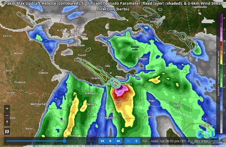
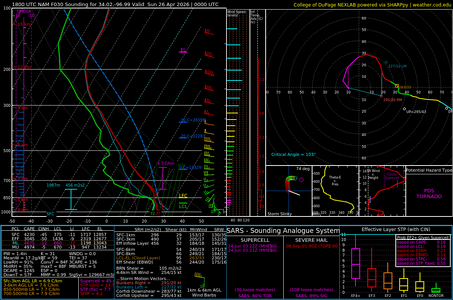
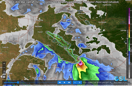
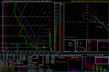
Starting with a look back at the Braman/Blackwell, OK tornado on 2026-04-23, here are the severe weather outlooks from Fox Weather and AccuWeather for what's predicted to be ahead through today and this weekend into early next week:

Dangerous severe weather to reignite over more than 55M across the Plains and the South | Watch

Congrats to all chasers who scored big yesterday! The upper-air/synoptic pattern will remain very favorable over the Arklatex and Mid-South early in the period and shift eastward and northward along the Mississippi River Valley early next week, so much chasing opportunity still lies ahead, although the more forested terrain might make for less spectacular video than yesterday. Good luck and success!
 
Looking at the 18Z HRRR, south-central OK looks like it might be in for a wild ride. My last two chases I got burned by thinking I knew better than some silly model and picked cells purely off of vibes, and each time missed out on a tornado that aligned closely with HRRR helicity swaths. Knowing that, I'm particularly interested in seeing if this significant updraft helicity swath just outside Sulpher persists overnight.
 

Attachments

  • DESI-HRRR-4-24-26-18Z.png
    DESI-HRRR-4-24-26-18Z.png
    2.3 MB · Views: 11
  • 2026042418_NAM_030_34.02,-96.99_severe_ml.png
    2026042418_NAM_030_34.02,-96.99_severe_ml.png
    102 KB · Views: 12
Saturday-Sunday: Classic no-brainer Plains chase days. Capping may be a concern, but there are enough model signals for storms that there will be tornadoes *somewhere*. Dryline, triple point, warm front are all players. I can't chase due to copyright infringement-imposed reduction in operations.

Monday: Classic/volatile Midwest trough ejection event that likely will fall apart morning-of due to early day storms and clouds (too much forcing). If we wake up with a pristine warm sector though, watch out.
 
Oh wow...
I'm heading down to Durant in a bit to hang out until initiation.
The spc mod risk overlaps pretty strongly with the Arbuckle and Ouachita "mountains" (or whatever passes for mountains in Oklahoma) so expect uneven terrain, dense forests, broken lines-of-sight, and an increased risk of flash flooding. Good luck everyone and be safe!
 

Attachments

  • DESI-HRRR-4-25-26-12Z.png
    DESI-HRRR-4-25-26-12Z.png
    2.4 MB · Views: 7
  • 2026042512_NAM_012_34.5,-96.5_severe_ml.png
    2026042512_NAM_012_34.5,-96.5_severe_ml.png
    100.8 KB · Views: 7
Monday: Classic/volatile Midwest trough ejection event that likely will fall apart morning-of due to early day storms and clouds (too much forcing). If we wake up with a pristine warm sector though, watch out.
I've been keeping an eye on this because it might reach north to within day-trip range of me in Wisconsin. NAM is enthusiastic about there being an Iowa/north-ish Illinois target; other models are more skeptical. I'm seeing your expectation reflected in the models - it's not clear what kind of storms will be in place that morning.
 
Today, 4/25, looks to have solid potential for any storm that can stay on or south of the warm front. PDS tor kind of soundings with surface east-southeasterlies beneath west-northwesterlies, lower 70s dewpoints, gets kicked off with well-timed shortwave impinging just near enough the triple point to pop off some discrete supercells east of the dryline and moving roughly perpendicular to it, east or east-southeast. Would probably be much a bigger day if the warm front lifted further north. Cloud cover, storm location, and only modest mid level winds, all still potential flies in the ointment. I don't even see any VBV profiles.
 
I've been keeping an eye on this because it might reach north to within day-trip range of me in Wisconsin. NAM is enthusiastic about there being an Iowa/north-ish Illinois target; other models are more skeptical. I'm seeing your expectation reflected in the models - it's not clear what kind of storms will be in place that morning.
Actually, after staring at the models a bit longer, I can be more precise about this: It looks like there's consensus currently on Illinois-area having favorable wind patterns (e.g., plenty of shear and curved low-level hodographs) regardless of how other things play out, and moisture looks ballpark similar. Temperature and CAPE vary a lot; I'd guess due to the differences in earlier clouds/precipitation. So like Dan said, it makes sense that morning storms would be the make-it-or-break-it factor.

Dan, even the models with a lot of morning storms don't seem to be putting much in central Missouri until later in the day, so you might have an opportunity regardless.
 
Secondary targets in the Plains are alive and well. I'm surprised how the beast of a tornadic storm south of Wichita Falls has barely anyone on it. The agitated cumulus on the dryline signalled it was coming.
 
By my reading, the parameter space was/is better-looking by the north storms - maybe that's it? Those storms are a bit more clustered now, though. But there's plenty of tornado ingredients across the entire area; I wouldn't be surprised to if any of the storms dropped a new tornado.

Edit: And the south storm is in the SPC's 5% zone rather than 10% zone, going along with the idea that chasers might have expected it to be outside of the optimal area.
 
Today (Sunday): CAMs are indicating plenty of secondary targets away from the typical dryline bullseyes, even some viable ones in eastern Kansas/western Missouri if storms actually do fire that far east (in range of a morning departure from STL). The jet core is farther west, but there is workable flow shown pretty much everywhere in the warm sector.

Monday: Models are starting to wake up on the early-day storm reality. The good news is that this will lay down an outflow boundary that could focus a nice corridor in the general vicinity of I-70, but the bad news is that storms are shown continually backbuilding along it through the day and keeping it reinforced with cool air (a very realistic depiction).

The dryline/OFB intersection *might* be far enough west to clear out and heat up, that's what I'd be watching for. Open warm sector storms to the south of the outflow might still work. The outflow boundary would be the 'go here' target if it can get a few hours of sun and not be 50F right on its north side, but right now that's in doubt. There could be potential for the outflow to transition to more of a warm front if it can lift fast enough.

Tuesday: A final compact shortwave kicks out over a primed warm sector, with potential outflow boundary or warm front plays in southern MO/IL, highly dependent on the outcome of Monday's storms. Like Monday, there's a lot of forcing and the potential for early storms and/or early upscale growth.
 
Last edited:
Back
Top