• While Stormtrack has discontinued its hosting of SpotterNetwork support on the forums, keep in mind that support for SpotterNetwork issues is available by emailing [email protected].

2026-04-14 REPORTS: IA/WI/OK/IL

Jesse Risley

Staff member
Joined
Apr 12, 2006
Messages
2,306
Location
Macomb, IL
I chased with @Kholby Martin and @Ethan Schisler. We originally targeted the Dubuque, IA area but then noticed more robust convection was initiating near the boundary in the mid-afternoon southwest of Waterloo which is where we originally intercept the first tornado warned supercell. It underwent several mergens before becoming tornadic near Independence where the first touchdown tore a roof off an implement building 100 ft away from me. We repositioned and saw another brief tornado just south of Winthrop, IA. I did not have enough time to get any still shots of these but did get some video of the brief tornado south of Winthrop. The cell continued to struggle but did produce a tornado that some saw west of Manchester but we bailed when storms were becoming more clustered and HP-ish. We noticed a cell on the southern flank had gone tornado warned north of Fairfield so we bolted down there just in time to see the wall cloud produce a funnel that treated us to a nice tornado for about 5 minutes near Onslow, Iowa.

1000018204.jpg1000018205.jpg1000018198.jpg1000018202.jpg
 
Last edited:
My initial target was Dubuque, half way up there a cell west of Waterloo got tornado warned. Back tracked west and caught up with cell just south of Waterloo. Missed the tornado but got some impressive wall cloud shots. Dealt with plenty of hail and wind on the way back.
 

Attachments

  • Waterloo.jpg
    Waterloo.jpg
    120.9 KB · Views: 11
  • Waterloo 4-14-26.jpg
    Waterloo 4-14-26.jpg
    168.2 KB · Views: 7
  • Storm Waterloo 4-14-26.jpg
    Storm Waterloo 4-14-26.jpg
    104.5 KB · Views: 7
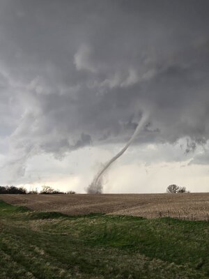
I chased a storm from east Iowa, through Madison in Wisconsin, then toward east Wisconsin. It was quite the chase; while I had no confirmed tornadoes (though there were lots of ominous-looking lowerings of the clouds), the storm was visually stunning.

I first saw tiny flecks of radar reflectivity in east Iowa. I drove back to Wisconsin to get ahead of them, because I thought they might intensify. The did, but very slowly. Meanwhile, I saw a cell getting big in central Iowa, and had a difficult decision of whether to make that my target, or keep on the tiny Wisconsin cells in the hopes that they would develop. I decided to stick with Wisconsin, since I considered that Iowa cell to be much more likely to be undercut by the cold front, it would mean a lot more driving for me, and recent HRRR runs often showed supercells developing in south Wisconsin in a favorable parameters space (though those storms sometimes faltered). I spent the next 45 minutes wondering if I'd decided my way into a bust.

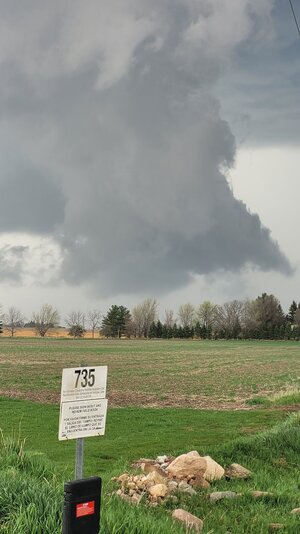
Finally, as they entered Dane County, the little storms consolidated and intensified. Initially, there was weak rotation on radar, both right- and left-handed.
1776389815312.jpeg

However, this storm was already producing hail. I drove through hail fog that looked like the ground was on fire, it was steaming so rapidly.

As the storm entered Madison, it organized rapidly. Suddenly, it had a classic right-handed supercell look on radar, and I could clearly see the RFD in person, with a horse-shoe shaped updraft.
1776390157514.jpeg1776390169956.jpeg
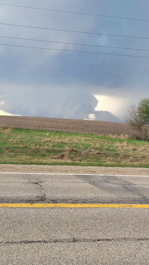
I chased that storm right through the middle of Madison, hoping desperately that it wasn't putting a tornado down in the middle of town. (Fortunately, the lack of tornado reports indicates that the worst Madison got was significant hail.)
1776390248331.png1776390258197.png1776390281277.png

Just after leaving Madison, I got a good chance to slow down and admire the storm for a little.
1776390380147-jpeg.29059

(I got a short timelapse here that I'll put in another post due to StormTrack's media limits.)
1776390446600.jpeg

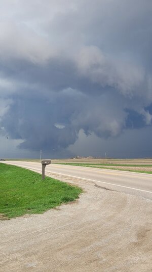
I continued with it east along the highway.
1776390489006.jpeg
Another supercell had developed right in front of it earlier. Since my storm was now the last in a line, I guessed that its tornado potential was decreasing. As daylight started to fade, I turned around, to head back to Madison.

There were now linear-mode storms in my path back. I didn't want to take chances, so I sheltered in a gas station and ate supper. The linear storm treated me to one last ominous-looking cloud lowering in the sunset, but I could see that this one wasn't serious.
1776390801191.jpeg
 

Attachments

  • 1776390380147.jpeg
    1776390380147.jpeg
    269.3 KB · Views: 29
I took the afternoon off work in the western suburbs of Chicago and then blasted off to the west with a target of US20 between Dubuque and Waterloo, IA. A dominant cell had formed west of Waterloo that produced a tornado near Eldora, but was not able to get there in time. I met the cell about 20 mi east of Waterloo near Independence, IA, where I was able to get impressive structure shots from a couple mi south of town. It had the impressive ‘Independence Day’ (pun intended) alien invasion ship look to it.
1777576909069.jpeg1777576934455.jpeg

I stayed on paved country roads parallel but south of US20 between Independence and Manchester. Several cells formed to the south and merged with this one, making the tornados it would produce difficult to see (I did not want to get that close to it being rainwrapped). Due to a gap in paved roads SE of Manchester because of the Maquoketa River I ended up further south, but this became fortuitous as the southernmost cell in the line strengthening near Anamosa showed some promise. I was able to drop south to IA64 in time to observe it as it moved across Jones Co. I was a bit ahead of the meso a couple mi east of Wyoming, IA when I noticed the rope in my rear view mirror. There were very few chasers or other traffic around so I was able to turn around quickly and drive a ¼ mi west to a good vantage point where I got what is so far my shot of the year. It only lasted a few mins total and was able to enjoy the last 2 mins of it in solace, with no other chasers or chaos, it was a special moment.
1777576972064-jpeg.29251


After this, I continued east towards Maquoketa, and enjoyed the sunset with the shelf cloud near Preston, IA.

1777577094148.jpeg1777577107998.jpeg
 

Attachments

  • 1777576972064.jpeg
    1777576972064.jpeg
    109.4 KB · Views: 2
Back
Top