Luke Penney
EF1
On Tuesday, we might have our first event within easy day-trip distance of me in Wisconsin, so I'm creating a thread for it.
(Looks like there's also a southern target; I think it makes the most sense for that to be a separate thread, but let me know if I should edit the title of this one to include it.)
Strong winds from the south will bring warm, moist air northward, with surface temperatures forecast in the 70s and dewpoints in the 60s. Moderate instability is forecast, with MUCAPE of 1500-2500 J/kg over much of the relevant area. Mid-level lapse rates are good, getting up to ~8°C/km. NAM and GFS disagree on whether there will be much in terms of low-level lapse rates (probably because NAM is forecasting clouds and GFS is forecasting clearer skies).
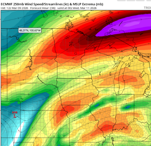
As is to be expected at this time of year, lower CAPE is made up for by stronger shear, with 500 mb winds getting to around 60 kts, depending on location. 0-3km SRH is concentrated along a temperature front, maybe getting up into the 400's or 500's m²/s² there.
The warm sector is initially bounded to the north by a warm front that switches to being a cold front (with models differing on exactly when that happens). That front also introduces extra vorticity.

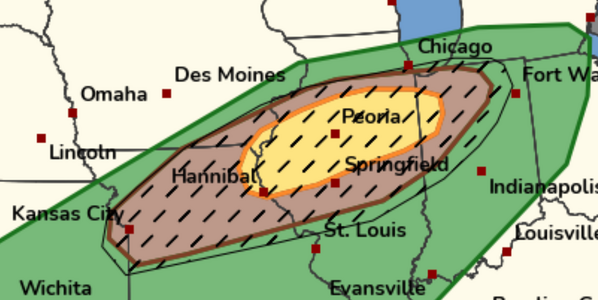
(Image from College of DuPage)
The best hodographs are north of the front, but instability is only south. Right along the front might be an interesting location because of that and the vorticity, if the cold air doesn't undercut the storms too much.

(Image from Pivotal Weather)
There's a little bit of capping, and I'm seeing initially-discrete storms in the models.
The models I've checked (mainly NAM, GFS, ECMWF) all show a relatively similar set-up.
Big question marks to me are the degree of cloud cover earlier in the day (with NAM and GFS disagreeing on that) and when exactly the warm front will become a cold front.
I think a storm getting on the warm front and taking advantage of the favorable winds there would be promising; otherwise, I'd look for warm-sector supercells in general.
(This is the first time I've created a Target Area thread, so let me know if I've made mistakes or missed anything big.)
(Looks like there's also a southern target; I think it makes the most sense for that to be a separate thread, but let me know if I should edit the title of this one to include it.)
Strong winds from the south will bring warm, moist air northward, with surface temperatures forecast in the 70s and dewpoints in the 60s. Moderate instability is forecast, with MUCAPE of 1500-2500 J/kg over much of the relevant area. Mid-level lapse rates are good, getting up to ~8°C/km. NAM and GFS disagree on whether there will be much in terms of low-level lapse rates (probably because NAM is forecasting clouds and GFS is forecasting clearer skies).
As is to be expected at this time of year, lower CAPE is made up for by stronger shear, with 500 mb winds getting to around 60 kts, depending on location. 0-3km SRH is concentrated along a temperature front, maybe getting up into the 400's or 500's m²/s² there.
The warm sector is initially bounded to the north by a warm front that switches to being a cold front (with models differing on exactly when that happens). That front also introduces extra vorticity.
(Image from College of DuPage)
The best hodographs are north of the front, but instability is only south. Right along the front might be an interesting location because of that and the vorticity, if the cold air doesn't undercut the storms too much.
(Image from Pivotal Weather)
There's a little bit of capping, and I'm seeing initially-discrete storms in the models.
The models I've checked (mainly NAM, GFS, ECMWF) all show a relatively similar set-up.
Big question marks to me are the degree of cloud cover earlier in the day (with NAM and GFS disagreeing on that) and when exactly the warm front will become a cold front.
I think a storm getting on the warm front and taking advantage of the favorable winds there would be promising; otherwise, I'd look for warm-sector supercells in general.
(This is the first time I've created a Target Area thread, so let me know if I've made mistakes or missed anything big.)