• While Stormtrack has discontinued its hosting of SpotterNetwork support on the forums, keep in mind that support for SpotterNetwork issues is available by emailing [email protected].

2025-05-15 EVENT: IL/IN/WI

Joined
Jan 14, 2011
Messages
3,483
Location
St. Louis
It appears likely that a bimodal supercell/tornado event is possible across the Midwest on Thursday evening. The two pimary targets appear to be focused on Wisconsin/northern Illinois and southern Illinois/Indiana.

In the northern target, the negatively-tilted northern stream and left exit region of the southern stream jet max will overspread a narrow tongue of 70F dewpoints wrapping into the surface low in southern MN. Everything looks quite pristine in this area, and there are enough model signals for storm initiation that IMO makes this the obvious primary target from I-80 into southern WI. Cons: The now-in-range HRRR paints a much different picture of the surface moisture situation, pushing the cold front to the Lake Michigan shore by 00z before any meaningful moisture return can take place. Storms may be confined in the forests of WI or Chicagoland, both suboptimal for chasing.

The southern target is also not one to sneeze at. A broad zone of dewpoints in excess of 70F will exist east of the Mississippi River by late evening. The southern stream jet streak will be reaching this area around 00z, and model support for initiation is trending upward here.

The main features to watch are the surface moisture situation and the capping concerns, both of which could be failure modes, particularly for the northern target. Most everything else looks pretty solid.
 
Last edited:
Dan pretty well covered it. I will note it seems to me that these setups with a classic negatively tilted trough and a moisture tongue wrapping into the surface low tend to produce despite any minor negatives (a more extreme example of this being April 26th of last year; 3/5/22 - Winterset day - also counts) while setups with a flat to positive tilt (such as this past April 28th) usually underwhelm despite an impressive warm sector parameter space.

It's looking like I will be able to stay pretty close to home for this one; might venture into northern Illinois for better terrain, especially if 3K NAM stays consistent with initiation there. Not a huge fan of the Enhanced risk being introduced way up into the northwoods, but I think the "sweet spot" for supercell tornado potential might end up being on the southern edge or even just south of it. Not backyard target bias at all...
 
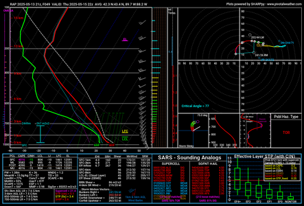
Box-averaged RAP sounding for southern WI/far northern Illinois at 22Z Thursday:

rap_2025051321_049_area_42.33-43.41.-89.71--88.21.png

One thing's for sure, weak lapse rates in any layer should not be a problem with this setup. Instability is upper-echelon for this region, especially prior to late June/July "corn-fueled MCS" season. One thing that's a bit of a head-scratcher for me is the less than spectacular SRH values on some model soundings, although these shown here should be adequate given the instability. However given how deep of a surface low is progged I would expect a much stronger LLJ and correspondingly larger 0-3KM hodograph than is being depicted on most solutions.
 
Model support for convection in the southern area is still sparse. It is the only place I can chase since we don't leave Atlanta until early tomorrow. Friday is more of a sure thing.
 
Seems pretty clear now that the southern target is going to be plagued with clouds and precip for much of the day. There's a narrow zone of insolation shown west of that, but I'm much less optimistic about it being enough to get sustained convection going. The northern target still looks great, and the previously-naysaying models like the HRRR are starting to come around with the moisture making it up there.

If I had no home target bias, I'd be leaving here by 6am, as this could be an early show with the need for final target adjustments to be complete by 1pm. My initial staging target would be Shorewood, IL on the southwest edge of Chicagoland by 11am. CAMS seem to think that the surface low arc of supercells may extend well south of I-80, making it possible to forego Wisconsin and hope for a northern Indiana play.

Right now, I'm inclined to stay in southern IL for the long shot south of I-72, especially since Friday will be either right here in STL (or west/south) and might also be an early-initiation day. Ending Thursday's chase in Milwaukee our South Bend will mean quite a grind to get back for Friday with any decent rest. No big deal when I was 25, but not so much now! I'm thinking a compromise of Champaign-Urbana along I-57 would keep the extreme southern end of the surface low arc in play while maintaining a position for the southern target. If morning satellite reveals clearer skies in the south, then I'll likely stay down here.
 
Last edited:
My general target area will be the I57 corridor between Matteson and Paxton, and possibly moving into IN. I have a scholarship awards luncheon that I am attending until about 2 with my wife and my family, but thankfully it is a lunch and not a dinner and I will be right off I80 in New Lenox in the southwest suburbs of Chicago so I can mobilize from there afterward. Capping was initial big concern south of Chicago (and passing up going to WI where initiation seems like a sure bet), but recent CAMs have been encouraging.
 
likely chasing the linear squall line as it enters sw michigan off the lake around 00z. Not wanting to mess with chicagoland at all. my early target was northern indiana but worried about capping. nice dinner on the lake around 4pm then dropping down to sw mich. or n. indiana if needed.
 
The expected MCS has yet to develop in the vicinity of the southern target. If that continues, concerns of northward-moving outflow into the incipient storms on the front would be mitigated. It appears the brief interval of overcast will also pass within the next 2 hours. Guidance still calls for initiation between STL and Springfield by 22-00z. The cap is shown killing these off after a couple of hours, but there is a short window for something to happen. The jet streak is on our doorstep and it's going to be go time soon. Non-home-target bias folks not going to Wisconsin should already be en route to Peru-Shorewood. I probably should be too, but I just can't pull myself away from what I see here.
 
Just staged south of Eau Claire, cap still holding strong but between the muggy air and the strong winds you can feel something trying to build.

Hoping for some initiation here within an hour, but uneasy about the storms to the west of MN taking the energy.

We will push as far east as I39
 
South of Eua Claire looks like a great spot. Could be brand new towers going on a fine line (visible satellite) in far southwest Wisconsin (2:30 pm CDT). Stay flexible for either those or if Minnesota unzips more.

All of that is on an excellent boundary with solid low level shear and convergence. Cell motion and closeness could be disorienting compared to typical SW to NE. If things organize as line(s) of pearls (not random) it should be manageable.

Minnesota stuff look like a line of shrimp, which is as good as kidney beans. Perhaps Wisconsin will do likewise.
 
I was considering going out this evening, but it appears that the cap will prevent any pre frontal convection in Indiana. Once things do start going up in Illinois, I expect it to go linear pretty quickly given the expected forward progression of the front.
 
South of Eua Claire looks like a great spot. Could be brand new towers going on a fine line (visible satellite) in far southwest Wisconsin (2:30 pm CDT). Stay flexible for either those or if Minnesota unzips more.

All of that is on an excellent boundary with solid low level shear and convergence. Cell motion and closeness could be disorienting compared to typical SW to NE. If things organize as line(s) of pearls (not random) it should be manageable.

Minnesota stuff look like a line of shrimp, which is as good as kidney beans. Perhaps Wisconsin will do likewise.
Thanks for the input Jeff! I was glad I managed to stay on the south side of the line (Gave me more flexibility for the semi discrete cells that popped) but it looks like north of Eau Claire ended up being the move. I was ultimately too far east of Arcadia to pivot behind the line and move north/east behind without getting pinched by hail.

Not too shabby for my second chase ever, a little bummed I ended up just a little too far south from where things were producing, but it's called chasing not catching for a reason, and the lack of roads around the driftless region made things really tricky.

A lot of HUGE lessons learned, and you'll never see what you don't go looking for.
 
Back
Top