• After witnessing the continued decrease of involvement in the SpotterNetwork staff in serving SN members with troubleshooting issues recently, I have unilaterally decided to terminate the relationship between SpotterNetwork's support and Stormtrack. I have witnessed multiple users unable to receive support weeks after initiating help threads on the forum. I find this lack of response from SpotterNetwork officials disappointing and a failure to hold up their end of the agreement that was made years ago, before I took over management of this site. In my opinion, having Stormtrack users sit and wait for so long to receive help on SpotterNetwork issues on the Stormtrack forums reflects poorly not only on SpotterNetwork, but on Stormtrack and (by association) me as well. Since the issue has not been satisfactorily addressed, I no longer wish for the Stormtrack forum to be associated with SpotterNetwork.

    I apologize to those who continue to have issues with the service and continue to see their issues left unaddressed. Please understand that the connection between ST and SN was put in place long before I had any say over it. But now that I am the "captain of this ship," it is within my right (nay, duty) to make adjustments as I see necessary. Ending this relationship is such an adjustment.

    For those who continue to need help, I recommend navigating a web browswer to SpotterNetwork's About page, and seeking the individuals listed on that page for all further inquiries about SpotterNetwork.

    From this moment forward, the SpotterNetwork sub-forum has been hidden/deleted and there will be no assurance that any SpotterNetwork issues brought up in any of Stormtrack's other sub-forums will be addressed. Do not rely on Stormtrack for help with SpotterNetwork issues.

    Sincerely, Jeff D.

2025-04-17 EVENT: NE/MN/IA/MO

gdlewen

EF4
Joined
May 5, 2019
Messages
375
Location
Owasso, OK
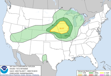
The SLGT risk target area in the Day 2 SPC Convective Outlook is out of reach for me tomorrow, but I would be interested in seeing a discussion by those who will be chasing tomorrow.

1744852529359.png

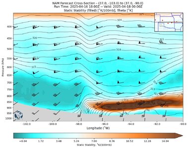
For my part, I am eyeing the dryline in OK (no surprise there), and a cap which seems to have an absolutely 100% chance of holding. The inversion at the base of the EML looks impenetrable:

NAM_Fcst_SS_20250416_1800_F30_20250416_1902.jpg
NAM Forecast Cross Section of Static Stability (SS) and winds along Latitude 37˚N, valid 4/18/2025 at 00Z. (See Lanicci and Warner, 1991 for the definition of static stability used here.) A mean static stability of ≤ 4.5˚/100mb is used by Lanicci, et. al. to discriminate EML from non-EML (elevated stable air masses) so the (white) center of the diverging colorbar is adjusted to a value of SS=4.5˚/100mb.

And the EML base has looked this strong since the NAM came into range. The only reason I have any interest at all is
  1. It's a dryline
  2. The cap is weaker near the dryline itself, and
  3. The possibility of underrunning due to the strength of the convergence of the winds across the dryline
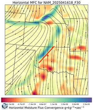
There is a strong component of the wind normal to the dryline in central OK (see below). I can think of at least one other event since moving here where it looked like underrunning led to a supercell: forming near Bristow and meandering through N Tulsa.

Anyway for tomorrow’s forecast, the convergence looks like this

NAM_20250416_18Z_F30_Horizontal MFC_20250416_1940.jpeg
NAM Forecast Moisture Flux Convergence valid 4/18/2025 00Z. The red bar and red arrow denote the approximate position of the dryline (based on the surface convergence pattern) and incident wind, respectively.

So we’ll see. Except for underrunning, I don't see a source of lift that can break or beat this cap. I’ll be keeping an eye on things tomorrow, of course, to see if the configuration sketched out above is validated. I expect I'll be staying home, though, and this has just been another learning exercise.


Lanicci, J. M., and T. T. Warner, 1991: A Synoptic Climatology of the Elevated Mixed-Layer Inversion over the Southern Great Plains in Spring. Part I: Structure, Dynamics, and Seasonal Evolution. Wea. Forecasting, 6, 181–197
 
Hello, I am looking at the models prior to today's event this evening near Omaha. It seems most parameters are better just south in northeast Kansas except one which I believe to be a forcing mechanism. Around 23z it looks (to me) like everything minus a forcing mechanism are enhanced down there. I see that small but very prominent kink in the 500 mb flow right in the enhanced risk area. Is that shortwave the only thing lacking down south? Or am I off base and missing something else much more obvious? Thank you!
 
Last edited:
Not able to make time for solid analysis today, but think there is stronger capping to the south that may not be overcome by the subtle wave. The northern area gets forcing from the cold front (although that presents its own problems). There is not much convergence along the dryline in KS, and temp/dewpoint spreads are high just east of the dryline there. SPC has a meso discussion for the northern area right now; doesn’t mean they might not issue one to the south of there later on.
 
I was just about to post when James did, and I agree with him. My first thought is that NE KS looks too far removed from the best lift. Clicking around on model soundings for 23z also looks like the cap stays in NE KS. I don't have time to post my thoughts in detail, but if you haven't seen it I highly recommend Gabe Garfield's video linked below, as it explains why sometimes lower end parameters get things done, especially on the high plains (he also has a part 1 that is good, but more basic than the part 2 liked here). https://www.youtube.com/watch?v=zxXS4pCbkrk
 
I appreciate your replies, thank you very much. I'll check out that video!

I forgot about the cold front up north, duh, thank you. Also TD spreads do seem a lot higher down in KS. That gives me a lot to chew on and look out for next time I'm analyzing things.
 
Last edited:
Back
Top