2024 Tropical Season Discussion

Dry slot looking decent now for tornado potential if that can maintain, though I’m still not considering chasing.
 
Looking ahead...from tiny acorns mighty oaks grow.
We're seeing the embryo of Ernesto in the circled area of showers and thunderstorms in the infrared image below.
This slow-moving disturbed area heading towards the western Caribbean needs close watching the next week or so.
It will strengthen and get into the Gulf of Mexico and threaten the US. Screenshot 2024-08-05 at 9.14.02 AM.jpeg
 
Takes a lot of patience looking & waiting for the next tropical-storm these days! 🥱
I've lived in the Tampa Bay area & Miami in Florida, and I've seen a lot of rain and flooding...so didn't need to see Debby either.
This tropical wave's slated a bit south of optimal, so we'll see how it interacts with the Yucatan and the southern Bay of Campeche.


Image.jpeg
 
Last edited:
Remnants of Debby place my area (southeast PA) squarely in the 5% TOR risk today, which is pretty rare around here. I haven’t tried to chase a setup like this before so I don’t know a ton about it, but I suspect it’s more of a random, nowcasting type of situation without an ability to target a specific area or initiating boundary. Almost like trying to chase an embedded QLCS tornado, Certainly not worth working too hard at it. Local terrain, traffic, etc. make it impractical to chase out here. It’s a little better about 90 minutes or two hours west of here (Lancaster area for example) as well as east in parts of southern NJ, but doesn’t seem worth the trip, and again not really “targetable.” Also can’t really afford to break away from work until the afternoon, and it seems the chance for discrete storms is better early in the day, with a line forecast for later. So I’ll probably just keep an eye on the radar in case anything interesting pops locally.
 
This next potential system looks to be the most dangerous yet this season if it forms. It will have lots of time over warm, open water and a whole lot of time to organize. But no closed circulation ATM = no forecast as far as I'm concerned, as even a minor wiggle at this point makes a huge difference in the long term track. The GFS track (in red) wants to threaten the east coast.


hhhhh.png
 
ATM = no forecast as far as I'm concerned, as even a minor wiggle at this point makes a huge difference in the long term track. The GFS track (in red) wants to threaten the east coast.
Don't the 12Z ECMWF spaghetti plots veer off without striking the U.S.?

This is a comment in general and it is not directed at Warren: I guess I don't the excitement over cloud clumps in the Caribbean when they are 10 days away. It seems to me it has a "cry wolf" risk with the public as we see these > 7 day forecasts/outlooks on Twitter frequently.

Addition: Within 2-3 minutes of posting the above, the item below was posted on Twitter with an explanation of why it was going to hit in 11days (U.S. coast). My point, exactly. And, I've intentionally left the"forecaster's" name off.
 

Attachments

  • Screenshot 2024-08-09 at 5.32.44 PM.png
    Screenshot 2024-08-09 at 5.32.44 PM.png
    2.5 MB · Views: 8
Last edited:
The storm clusters generally do generate excitement among us weather geeks, but I agree, many of the ideas / thoughts are certainly not ready for public consumption, especially via forecasters.
In some ways, there's a stirring of the pot, generating buzz / hits on social media. YouTube now has a ton of suggestions that need ignored.
With this new tropical potential, who truly knows the vagaries of the subtropical high's track-influence, especially so far out in time and space?
 
Remnants of Debby place my area (southeast PA) squarely in the 5% TOR risk today, which is pretty rare around here. I haven’t tried to chase a setup like this before so I don’t know a ton about it, but I suspect it’s more of a random, nowcasting type of situation without an ability to target a specific area or initiating boundary. Almost like trying to chase an embedded QLCS tornado, Certainly not worth working too hard at it. Local terrain, traffic, etc. make it impractical to chase out here. It’s a little better about 90 minutes or two hours west of here (Lancaster area for example) as well as east in parts of southern NJ, but doesn’t seem worth the trip, and again not really “targetable.” Also can’t really afford to break away from work until the afternoon, and it seems the chance for discrete storms is better early in the day, with a line forecast for later. So I’ll probably just keep an eye on the radar in case anything interesting pops locally.
Some of the best chase terrain is there the further south in the state of Delaware. And, my usual chase partner was about 100 yards or so from the New Castle County EF1 (of course, it helps that he works in Wilmington, DE).
 
I think initial, long track forecasts do offer some public awareness, as long as there is a clear notation of possible track errors. AL98 has shifted east, but the original / current forecast track is a threat to Caribbean interests and it could still make a left turn into the east coast. There are also considerations for mariners traveling into the Atlantic and coastal wx issues far away from the storm even if it turns, e..g, tides, rip currents, surge, waves, etc. Cyclones are very difficult to forecast before they actually have a steady core with height and become part of the overall pattern.

The problem is when people take the long term forecast tracks and present them as "guaranteed" strike zones.
 
I think initial tracks do offer some public awareness
Of what?

We saw "forecasters" last week all over the internet telling us that this storm was going to strike the US. That is now highly unlikely.
All these do is contribute to the perception of "I wish I could keep my job and be wrong half the time!"

What, exactly, do we want people to do with "awareness" eleven days out?!

On private fora like StormTrack, it is fine to offer as much speculation as anyone wants. The public doesn't see them. But, 'we' -- the meteorological community -- should be much more responsible with these forecasts beyond our level of skill. I have pledged to my blog readers that I will not provide tropical storm forecasts beyond 7 days into the future. We have some skill at that time interval plus people need to start purchasing supplies and making plans.

The problem is not confined to tropical weather. How many times have you heard confident forecasts of snow amounts 4 days out that become "well, if it goes north, we'll get 2"; and if it goes south, we'll have 4-6 inches the night before? We do this to ourselves all the time! I did it to myself with the High Risk for Kansas on May 7th. There was no necessity for me to issue a special forecast on the 5th. Zero tornadoes occurred in Kansas.

We also do it -- constantly -- with meteorology's consistently little to no skill seasonal forecasts.

If we want the public to give us the respect we need, so they will take our forecasts and warnings seriously and take the measures we recommend, we need to stop disseminating forecasts to the public that are beyond our levels of skill.
 
There is indeed a big difference in telling people: "A giant hurricane is *going* to strike the East Coast in 11 days," vs., "There is a system (wave, low. etc.,) in the Atlantic that "needs to be watched." Most people with ignore such news, but a few will be encouraged to think about their readiness. It's like telling people "Peak hurricane season is here."
 
I think initial, long track forecasts do offer some public awareness, as long as there is a clear notation of possible track errors. AL98 has shifted east, but the original / current forecast track is a threat to Caribbean interests and it could still make a left turn into the east coast. There are also considerations for mariners traveling into the Atlantic and coastal wx issues far away from the storm even if it turns, e..g, tides, rip currents, surge, waves, etc. Cyclones are very difficult to forecast before they actually have a steady core with height and become part of the overall pattern.

The problem is when people take the long term forecast tracks and present them as "guaranteed" strike zones.
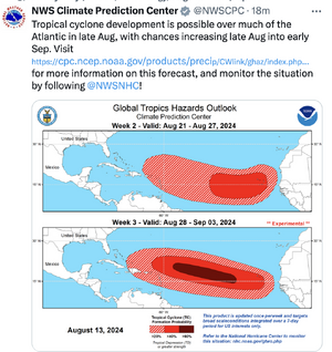
Yes, a big problem is individuals taking a single deterministic model run day 10 and beyond, running with that, and treat it as "this is what is going to happen." No uncertainty or caveats given. And what makes it worse now, individual ensemble member tracks and plots are now available, so they will find *one* member on any global model that shows a direct hurricane hit in the CONUS, and take that and post.

IMHO, doing this irresponsible and unethical, given the state of the forecast science, *and* that fact chaos theory kicks in days 6-7, so that is a hard limit people should end at for any solid specifics. Hype posts like this are nothing but self-serving, merely to get clicks and likes to monetize weather hype, and it really has got out of control in the last several years with channels popping up with the same operating mode -- always a tagline on their thumbnail image with some over-the-top, dramatic, cheesy phrase, like "things are about to get weird!" with a map showing all sort of ambiguous flashy colors and arrows. Even when the weather currently and in the next week are quiet or inactive across the U.S., still you see this. Deplorable.

And people will defend it as in, "we are being informed and kept safe b/c of this!" I am tired of that lame, weasel excuse. It is basically a red herring to allow people to say or do whatever they want regarding weather. Too much of anything is many times just as bad as too little. More (hype or warning) is not always better!

And too many people buy into this nonsense, and many are put into a semi-permanent state of stress/worry b/c of this. Tell me, how is this alone good for society? And then inevitably, many people become apathetic/distrusting of weather people in general. This has real world consequences -- among them, it makes the job of meteorologists everywhere that much harder.

And extreme weather hype and flowery language/descriptors are not confined to individuals on social media, a number of larger organizations now do essentially the same thing in some form.
 
And, here's another useless product.

It is pure climatology. Of course, tropical systems will form in these regions in August and September. But, one could misinterpret this as thinking the U.S.A. is safe.

The product adds nothing we don't already know and can be misleading.
 

Attachments

  • Screenshot 2024-08-13 at 2.48.28 PM.png
    Screenshot 2024-08-13 at 2.48.28 PM.png
    726.3 KB · Views: 4
Move a few letters down the alphabet, from Beryl to Ernesto, and what a difference. 🤣 Composite Image 12:20 Z GOES-East
But seriously, no pristine conditions for development and strengthening here, folks. The dual nemeses of dry air and adverse wind shear sure beat up the western side of this storm. While still a large force to contend with (if you're in Bermuda,) it's not forecast to go major to a Cat 3.Image.jpeg
 
Move a few letters down the alphabet, from Beryl to Ernesto, and what a difference. 🤣 Composite Image 12:20 Z GOES-East
But seriously, no pristine conditions for development and strengthening here, folks. The dual nemeses of dry air and adverse wind shear sure beat up the western side of this storm. While still a large force to contend with (if you're in Bermuda,) it's not forecast to go major to a Cat 3.View attachment 26201

Ernesto is a good example how it is not just about very warm or well-above normal ocean temps concerning hurricane intensity.

Ernesto has been over ocean temps above normal and more than enough to support a Cat 4
or 5 strength for most of its existence, but has struggled to get to minimal Cat 2. Why is that?,
b/c the atmosphere has not been ideal. Light-moderate wind shear has been an issue, but I think
more importantly, the environment around Ernesto has not been ideally moist w/ 700-500 mb RHs
55-60% much of the last few days, and now, according to the 12z SHIPS run, the RH is 49%.

For a hurricane to really thrive in intensity, you typically want at least 65-70% 700-500 mb environmental RH around the storm.

There is a lot of focus, and at times too much focus, on ocean temps increasing as the globe warms. That is a valid area of research and of course is a factor in hurricane intensity changes, but all the warm ocean in the word means little for more intense hurricanes *if* the atmospheric changes are the other way. That can be increasing average wind shear and/or lower average RH in the tropics and subtropics. Either one of these less favorable over time will put the brakes on many hurricane intensities.

I would argue that ocean temps of the three main factors for TC development/intensity are the least important. Why?, b/c ocean temps in most of the tropics year-round are more than enough to support strong hurricanes/typhoons/cyclones, and yet even during the peak season for each tropical basin, only a small fraction of waves/disturbances ever develop into TCs, and even less become intense. This proves how important wind shear/mean RH through the depth of the atmosphere is.

Unfortunately, I have found these key atmospheric factors often get shoved aside when changes in hurricane intensity in warmer global temps are discussed in the mainstream. They cherry-pick one factor/parameter (ocean temps) and run w/ that w/ a dumbed-down, linear 1-2-3 correlation = causation that makes for concise, catchy quips that fit a particular narrative/ideology/platform. That is an insult to the science, among other things. Things are far more complex for phenomena like tropical cyclone development and maintenance than often portrayed, and to act like we have it all figured out is putting the wagon in front of the horse.
 
Last edited:
Back
Top