2024-05-30 EVENT: TX/NM/OK

sdienst

EF1
Joined
Sep 25, 2006
Messages
96
Location
Friendswood, TX
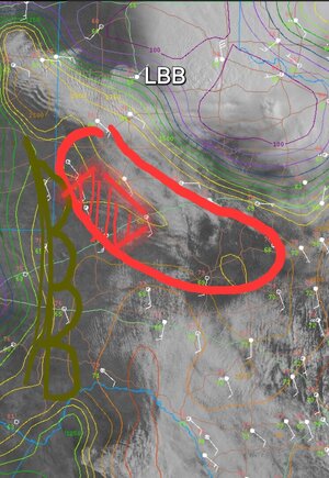
A bit far out in this current pattern to have any forecast confidence, but past two runs of the NAM have a decent looking setup across the south TX plains with quality moisture making its was back west and a dryline setting up in west TX. Still a couple days of moisture scouring MCS's possible between now and then so I'll revisit the look on Wednesday evening I guess.
 
I think the this pattern of post MCS boundary layer firing is gonna happen again tomorrow . will keep an eye on obs , satellite , for boundary location.. models are trending the I-27 area right now for CI..have to see where that bndry line lays tomorrow after 18Z.. I think the shear parameters are going to be sketch though.. any discrete will have super cell quality, but tornadic .. isolated at best with strongest in flow ahead of the MCS I think.. but the 4-6km doesn't look that great ..maybe CAPE strength can offset that when , if models are right from 23-01z the it combos with 850 winds ramp up to 30-35kts .. either way I'm a bit skeptical but I think I'm gonna hang out in lubbock til about 18z, check the insitu, and RAP/RUC analysis , if things stay on track, start heading towards Snyder.. I gotta be near Dallas tomorrow night anyway , so I'm compelled to make my way east .. but I'll zig zag along the way ! Lol
 
Also, I think there is a chance they upgrade to enhanced tomorrow from lubbock SE to Dallas.. mainly for winds hail and still keep a 2% .. with slight potential for 5% by 1630z if some of the trends in more recent runs continue and some of the localized shear parameters increase out ahead of the main line as they push east from lubbock
 
Still early yet. But the boundary dropped below lubbock . Will have to see how much it retrogrades back to the north later today or if it hangs out once forward motion slows. Models keep Sfc to 850 winds 15 to 20kts until after 00z bit there could be some localized thermal meso high compression along the boundary ... right now I think La Mesa is the target or just south for later , boundary depending.. cleanest inflow .the RAP does show a little northerly boundary return later today.. shear still looks super cell but a lot of the cams generate multicellular to MCS by 01 to 03Z so the window will be short to pick the cleanest cell before they all get swallowed up lol .. but this is my target area today .. inside the box seems to be best potential.. but again that's outflow boundary placement and how much it retrogrades maybe
 

Attachments

  • Screenshot_20240530_095032_Chrome.jpg
    Screenshot_20240530_095032_Chrome.jpg
    189.1 KB · Views: 19
Was out very late last night on the storm from Clovis to Morton area, and had a scare (thought I was being robbed in the middle of nowhere, long story) so I got up just a short while ago. Headed to Brownfield and will probably head west from here. Turkey towers prevalant in the west. Seems like just to my west/southwest is where that outflow boundary is meeting the dryline. That may be very magical today
 
Looks like there might be a squeeze play between the outflow boundary and the dryline near Tucumcari. If a wedge of moist, unstable air can be maintained south of there, it might be another interesting evening in Clovis and/or Portales, for the third night in a row. Eastern column of counties in NM now included in a severe thunderstorm watch along with parts of the Panhandles. Edit: Looks like that wedge is getting squeezed out down to about Portales. Might be best from there southward.
 
I am thinking that 'wedge' of moist/unstable air will be the best play today, wherever it ends up settingup. CI south of Portales. Area near me between brownfield and plains struggling.

Word to the wise out today - Can say with experience last night that most of those back roads are likely flooded out and totally mud. Pavement is crucial today
 
Hanging out just outside of Seagraves. Storm near Bledsoe looks best right now, but deeper moisture and backed winds are in this Denver City / Plains / Seagraves area.

IMG_8883.jpeg
 
Ben isn't wrong .. lots of flooded secondary roads. Gotta be real careful.. happens inside of 15min after maybe less in some spots.
 

Attachments

  • 20240528_191435.jpg
    20240528_191435.jpg
    358.2 KB · Views: 10
Yeah I had to backtrack 15 miles last night because of flooded roads. Storm near midland seems to be sucking in the boundary. I'm heading that way
 
I was surpeised the outflow bndry hasn't really stopped its press SSW until perhaps in the last 30min..perhaps the retrograde will start happening and bring the cells firing along it back into better near sfc moisture.... ..midland to garden city is tight..but that midland cell took off..the ET is excellent .. I'm in garden city now watching the cell there .but it really pinched off the amount of terrain these can work in
 
Agreed on the Midland cell looking like the best player right now. It's about to ingest a north-moving segment of the boundary. Best tornado potential though looks to be in the next 20-30 minutes as it overtakes that. There is a more favorably-oriented segment of the boundary to the southeast that may become a player if the storm can establish some new updrafts farther east.
 
Confirmed tornado skirting KMAF, observed by NWS folks there. Unfortunately motorists nearby have sought shelter at underpasses, probably from the hail but there's a tornado, too. Not good. Also, trying to understand why NWS does not have the radar in SAILS3.; updating at 5 minutes which is not good in this situation.
 

Attachments

  • TXDOT_MAF.jpg
    TXDOT_MAF.jpg
    30 KB · Views: 11
Back
Top