2024-05-25 REPORTS: OK/KS/TX/NE

Joined
Jan 14, 2011
Messages
3,217
Location
St. Louis
No time for a full report, but you can glean some of it in the EVENT thread. I got on the storm south of Wichita Falls just minutes before it produced a strong tornado at Windthorst. The tornado started in the southern part of town as a multiple narrow-vortex reminiscent of Wakita 2010. Fortunately, it did not appear like it did much damage in town as I did not see much debris being lofted. I made a close approach to the tornado east of town. I stayed with the storm to near Madill.

may2523b.jpg

may2524c.jpg

may2524a.jpg

Video:

 
A complete disaster and failure for me, adding to my increasingly serious consideration of abandoning forever this avocation that I once loved and probably still do yet only causes me regret, profound disappointment, and feelings of incompetence.

We departed from Garden City KS at 10am with a vague target of Altus to possibly south into Texas around Vernon/Seymour. Thought there would be plenty of time to refine the target by the time we got down that way. Never expected storms to initiate that early. When they did, we were not even quite to Altus yet and the northernmost storm was nearing Vernon, so I was already in a bad spot relative to the southernmost storm in the disorganized line that had quickly formed. Tried to intercept the northern cell near Frederick but it split and ended up blocking our path so backtracked out of it back to Altus. Now we were behind the line with little or no chance of catching up to anything with storm motions ranging from 35-45 to the NE. Didn’t seem practical to get to the southernmost TOR-warned cell in NW TX, especially as at the time there was another cell to its immediate west, meaning we’d have to drop far enough south to come in underneath that cell to get to the lead cell, or drive directly through it which of course was not a reasonable option.

We watched outflow kill off other new development that tried to initiate off the dryline. As the storms on the original line began to separate, we tried to pick up the storm at the northern end of the original line now north of Lawton, but just could not catch up. We continued north toward the now-better-looking storm up near Seiling, which at one point had three different TOR warnings on it and a confirmed tornado, but just could not catch up.

Decided to bail and head to Stillwater for the night. On the way, heading due east to Stillwater, another storm formed and we tried to catch up to that just before dark, deviating north to Perry, but we could not catch up to this one either. Of course, it went on to receive a TOR warning about 30 minutes after dark.

This was not even a day to “be happy with what you saw.” We saw absolutely nothing interesting. Caught behind the action all day, bouncing around like a pinball, endless driving. I’d say the root cause was simply not getting down to my target area early enough. But did anyone expect initiation that early? Based on its outlooks, I would say even SPC did not. And then the other error is I probably should have tried to get to the NW TX storm, as futile as it seemed at the time. Maybe I should have more quickly decided to do that, but I’m not sure it would have made a difference.
 
Targeted the OK/KS border and ended up waiting in Seiling for CI. It was of course obvious by morning that early CI in N TX was going to be a wildcard, but I strongly disliked the idea of targeting that region, probably to a fault. Global NWP had for days consistently depicted two distinct waves of convection: one in the afternoon in TX, and the other beginning around dinnertime in KS and N OK. QPF signals suggested the TX activity would actually die off for the most part before 00z, thus my extreme reservations about considering it as a chase target. It looked to me like an earlier, subtle shortwave would kick off TX storms premature to the high-end environment materializing near 00z, and the result could be a quick mess with little hope of recovery... then, the departing shortwave could potentially shut those storms down as the LLJ finally ramped up. Naturally, one of those cells S of Wichita Falls did still manage to produce the only quality daytime tornado of the entire event.

By 5:30pm, there was one robust cluster of organizing cells to our NW in Beaver Co., right where CAMs were nearly unanimous in tracking a monster along the OK/KS border well into the evening -- but moisture return still needed a couple more hours for >65 F dews to make it up there. Fortunately, another cell exploded to our W near Arnett. We sat in Seiling hedging between these options, since the S splitting cell was headed right for us in the better moisture. We started to head N on US-60 toward the KS border option just before 6pm, but as soon as we did, a big RFD cut was evident visually to our W with the Arnett/Vici right mover. In short order, a stout, backlit funnel descended inside the cut, so we whipped it around to go back S toward Seiling. We caught maybe 1-2 minutes fairly unobstructed of the Mutual tornado from the distant E (we couldn't verify it was on the ground in real time due to terrain) before rain and hail from one of the approximately 68 new updrafts exploding everywhere within the northward surge of contaminated air blocked our view. I took no pictures or video, as I was driving the whole time.

The appearance of the base and RFD cut leading up to the brief Mutual tornado was very impressive, to the point where I felt confident in a stout, longer-lived tornado. In hindsight, I can only assume that literally *right* as the tornado began, the sea of outflow-contaminated, theta-e-deficient air belched out by TX activity hours earlier finally slammed into our area (looking at a loop of sfc obs this morning supports this). Within minutes, everything around us looked like stable mush, and that continued the rest of the day... until right at sunset, when we watched explosive CI overhead in Enid, which of course would go on to produce a damaging midnight tornado near Claremore.

This is one of the more depressing chase days I can remember in my 19 years on the Plains, but at this point it's difficult to rank it among the others this year alone. The incredibly rapid evolution of the Vici/Mutual cell into an LP tornado producer removed any doubt about what kind of day we would've seen in OK and S KS if everything were the same *except* for the extent and severity of outflow from the early TX storms. Two days earlier, I had been similarly concerned about early afternoon TX storms impacting the quality of inflow air along the dryline, but the Eldorado/Olustee beast in SW OK was the outcome there. In my view, even the microphysical characteristics of the TX convection was a variable that, if nudged differently, could perhaps have led to a considerably different outcome in OK/KS. I find it hard to regret my targeting decision given the information I had when leaving at noon. What I do regret is that 2024 has now squandered something like half a decade or more worth of high-quality synoptic setups with virtually no productive output for chasers on those well-advertised days (talking about the core of the Plains here, not including IA), and yet all sorts of after dark destruction in the jungles. What a nightmare.
 
I went in to this half-heartedly and came away with results that reflected it. I indeed went west on I-40 as I said I would in TA, but got suckered down to Lawton, where I went southwestward toward Chattanooga. Storm went tornado warned quickly and I was there but it blew up into a linear mess and chased me back to Lawton. I then went northward toward El Reno to catch the northernmost southern storm and couldn't catch up. Like Jim, I then went north toward Okeene to try to catch that storm, but it decided to take off like a rocket and left me in the dust. Had a cell develop over me, go severe warned but it was off to the races and I didn't have the want or will to even try to stay with it.

Didn't see anything of substance yesterday which is my own fault because I didn't want to drive deep into North Texas. Not heartbroken by it, but what a waste of time.
 
@Ethan Schisler and I we're also on the Windthorst storm. We dropped southeast from Wichita Falls and intercepted about 10 miles south-southwest of Windthorst. We followed the storm to near Bellevue but then had to cut the chase and go back to Wichita Falls due to a flat tire. There was no shortage of tornadoes with this storm which kept cranking them for probably 30 to 40 minutes.1000010874.jpg1000010860.jpg1000010858.jpgScreenshot 2024-05-25 at 10.19.42 PM.png
 

Attachments

  • 1000010871.jpg
    1000010871.jpg
    287.9 KB · Views: 8
Last edited:
Got too worried I'd miss a huge show back in Oklahoma, so I picked off one of the initial storms near Frederick and stuck with it for awhile back to metro. Shoulda continued down 44 and would have gotten to the Windthorst storm in time.

What a messed up day. Kiss of death 15% for sure. That southernmost storm had a real good radar presentation for a long time. I was just hoping something in OK would do that. Once it became obvious that would not happen I headed home.

I'm not sure how many times they plan to rile up Oklahoma for nothing but it's going to be catastrophic for normal folks to keep seeing these hyped days busting and days like Sunday that weren't even really talked about in advance with tornadoes in OKC metro.
 
Seems a lot of us had a challenging chase.

I usually have a very flexible job but very occasionally cannot get away. I started Saturday from Denver, and anything beyond 6-7 hours was an likely target. My decision of chasing Kansas was made for me.

Checking surface observations. I was skeptical moisture would be in place in Kansas. Hodographs were ok but not great. I knew if cells paralleled the OK border the roads would be terrible. Storm motions were fast. Plenty not to like and I was leaning on staying home.

However, mesonets were reporting better than expected moisture return early, and I have only chased twice this season, one Goodland bust on a similar day where too much competing convection ruined things, and a nice little NE CO chase early this week that was productive for structure. With all that in my mind, I debated this chase heavily but eventually settled on going for it since many meh setups this year have defied expectations and we are approaching a blocking pattern.

Departed for Greensburg initially, and arrived almost just in time for the Kansas storm of the day south of Jetmore in its early life. Storms were already too close together and I considered this was likely going to be a bust. I was late and poorly positioned so had to deal with either a core punch or wait and stay right behind the cells until roads let me slide in from the south. I picked option 2, wait. I tried to follow east on annoying road choices, used one dirt road and found as usual in that area it was terrible, so I stayed to pavement and had to go Bucklin to Medicine Lodge. The positive to my series of bad decisions is I saw only a few other chasers because few were as foolish to leave late or try to position from a bad angle.

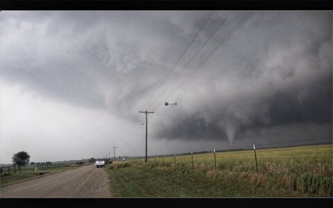
For all of that I did make it to the storm that sadly damaged Anthony area when it was near Medicine Lodge, and had the same view as most - a couple minutes where you could see a wall cloud, and some nice updrafts on the W or SW side. It then got massively rain wrapped and wrapped up more after the merger from the OK left spit complete. I took 3 cell phone pics and never opened my camera bag.

3 tanks of gas, a nice free weekend day lost, and half of today to recover, 14 hours door to door driving with barely any stops, 1000 miles on the car, and a thorough car wash needed. Defninitely not feeling great about the choice to invest in what was a risky proposition, but this is the hobby and we get a result of our decisions and the luck of nature's randomness. A couple less storms and a few less splits and this could have been a good day.

I did draw a solo chase map for out and back chases with a radius 4-6 hours from my home base two years ago that does not include this Saturady KS chase territory (South of KS400, and East of 183), and so it is my own fault that fear of missing out got me on the road on a setup I was not that sold on in territory that is a challenge and ignored my own previous boundary setting for a chase of this nature.

Chase rating: Two thumbs down and a raspeberry sound. :p

For everyone thinking of quitting or depressed about chases this year, I have been there and I implore you don't quit if you still love parts of chasing. Sit down and think hard about the type and kind of chases you enjoy and the investments you are truly willing to lose. If those parameters, terrain, time, cost, whatever are not there for you - don't invest and don't despair at what you miss! I have seen a lot, and I mean A LOT, of upset chasers this year very emotionally attached to busts and misses. I used to be that way too, but changed how I think about chasing. After all: I choose to pursue this and I know the risks, rewards, costs. I still get frustrated and kick myself for bad decisions, but by pulling way back on the days I attempt I am dissapointed less and invest less. Saturday was a day I did not listen to my own voice enough on how the forecast would play out and I broke my own chase map boundary a bit, but overall I bust less and less and enjoy the chases I do go on more. So a bust here in there is annoying and costly but in the big picture not a big deal. It has been a process of gradually changing the way I think and act about chasing to keep it viable for me. I know we all lust for certain previous years of magic with beautiful storms and terrain , predictable forecasts, etc. but: it is true in chasing and life - you can almost never get the same magic back and we have to adapt with the situations.
 
Went to head out chasing, but realized early on that my trying to catch up on neglected stuff over the last couple of weeks got me too late out the door to get there in time. Instead I turned around and went home where I was wakened by Storm Shield telling me there was a tornado warning for my area in Bentonville AR. The circulation seemed to be heading my way. I watched for about ten minutes until I lost my internet and cell phone service, so I woke my wife up and suggested we hit the basement. Watching my outdoor furniture flying by my basement door I suggest then that we go into a room in the basement. It passed with just a few trees going down and nothing coming close to the house.
Early in the morning we found out friends in Bentonville and Roger’s weren’t so lucky so my wife and loaded up the truck with chain saws and spent the morning clearing trees. We finished up at two friends houses and had one more stop. Our neighbors were at their 2nd home on Beaver Lake, a few miles East of Rogers AR, where we were unable to because of all the trees down. Unfortunately, the roads were impassable to get there, so we’ll try to get there tomorrow morning.
 
Yeaaah...I also botched this chase. My original plan had been to be in or near Snyder, OK (literally 20 minutes from my house) at initiation to give me time to adjust based on radar trends. Instead, initiation happened hours earlier than expected while I was sitting in my living room. I hustled out the door and went to Snyder as planned because I was still expecting the show to be more discrete and I wasn't prepared to commit north or south yet. In hindsight, I probably should have gone straight south to Vernon. Once in Snyder, I toyed with the idea of pressing south into TX, and even went as far as driving down just south of Frederick. I was at risk of getting ran over by the cells running along the Red River though, so I went back to Frederick with the intention of letting the NE moving storms move up and to my east and then I would take OK-5 east and fall into position behind them. Instead, more cells fired directly to my west and northwest, so I started back north on US-183 to get out of their way. I was just south of Roosevelt when I realized I was losing the race and the first hailstones started falling. Quarters? No problem, stick to the plan and press north. Golf balls? Starting to sound a bit concerning, but judging by the clear sky ahead of me I'm almost out of it. Then the road turned NW into Roosevelt, Roosevelt's low speed limit, and into the rapidly strengthening hail core. I started seeing a few tennis balls, maybe a baseball or 2. I got through town and north out of the hail core without losing any glass, but I definitely earned a few new hail dents on the Xterra.

Getting a surprise schwacking with 2.50"+ hail was the most excitement I had all day. At this point I had been chased up US-183 to near Hobart, and was now behind the outflow from the southern storms in rather pleasant, though stable, air. In the meantime there were active tornado warnings down near Wichita Falls, and just across the state line in KS, both out of reach. I hung around the general area for a bit longer and even made some friends in the form of a very chatty cow and a tarantula with a death wish hanging out in the road.

20240525_180647.jpg
20240525_202159.jpg

After bidding my new friends farewell, I ended up on another cell from near Roosevelt up to just east of Cordell. The storm showed a mid-level mesocyclone on the higher tilts of the KFDR radar, but visually it appeared elevated without a distinct updraft base, so I gave up and went home. I did get a pretty sunlit picture of the storm as it moved off to my NE though.

20240525_193610.jpg

I wanted to share a few thoughts about busts. I think what makes these big day busts sting so bad is the anticipation and the expectations. Just as an example, back on 30 April I went on an impromptu chase of a tornado warned storm near Roosevelt, OK (I really have been to Roosevelt a LOT this year). I had zero expectations for the day, saw zero tornadoes and yet was absolutely giddy about the structure I saw and the overall chase. Then you have days, like yesterday or 27 April or 6 May, that are well advertised with high potential, and yet I am disappointed with just structure. All of a sudden just the act of storm chasing and being out on the Plains isn't enough. The first example was all "profit" because I had assigned no expectations to it. The others feel like a net loss, I think, BECAUSE of the expectations assigned.

This chase may well be my last big chase for awhile though. And by big I mean driving hundreds of miles in a day for it, rather than a day like Eldorado where I drove a total of MAYBE 100 miles. I am driving up to a camping music festival in Michigan the second half of June, and it would probably be wise to take it easy on my car and my wallet between now and then. When I get back I'll have a couple of days and then I'm getting my kids for the rest of the summer. That takes us to August, then I'm moving to the Colorado Springs area in November. I'll definitely still chase any local setups though, but with my upcoming move I'm just now realizing I have no idea the next time I'll be chasing a high potential day on the Southern Plains.....kind of sad to think about. Anyway, 'til the next one!
 
Last edited:
I knew southern Kansas would be my target so I lazily worked my way there from Omaha, not much caring that the storms were going up about the time I was just reaching Wichita. Figured they had an hour or two to get into anything resembling moisture anyway. Posted myself south of Medicine Lodge on the opposite side of the road hole that exists south of Coldwater and just waited for it to come to me. Storm didn't look all that impressive, the base was miles high and it had lost most of its structure that it had apparently previously had.

About the time it reached 281, a little garden shower remnant of a previous left split ran into it, and my thinking was this was a small enough storm to possibly lower the cloud base on our sup and interact favorably with it. My intuition was correct and soon afterwards the base lowered, the rotation really began to pick up, and things finally started getting interesting. This whole time the inflow from the southeast was absolutely cranking at around 40 mph with thick dust being carried miles into the notch. Visibility was nada at times depending on which field you were next to. As I was positioning five or six miles east of Hazelton, I noticed another left split from the southwest approaching the storm which would put them on a collision course in about 10 minutes. This storm was much larger than the first with much, much more precip so I thought our chances for a tornado were running out quick.

About this time, the RFD on radar had an insane surge. At first I thought it might have been the storm gusting out, but quickly realized the inflow was wrapping around it as well and it appeared a tornado would be likely. The wall cloud at this point was very low and spinning rapidly with huge walls of dust being kicked up to the south by the RFD. I stopped the truck a couple miles directly east from it (not exactly great positioning given its movement but continuous east options were limited and this was a good dirt road). A brief needle funnel emerged and I thought for sure a fat tornado would be dropping. See pic below.

Literal seconds later the storm from the south rammed into this one and started torrentially raining into it. Visibility of the wall cloud went to zero in a matter of seconds and I bailed east. Thankfully the dirt roads were good because I could barely see them at times. It sounds like there was an actual rain-wrapped tornado associated with this but despite the hundreds of chasers on it, I don't think I've seen a single photo of one. That left split hit this storm at the worst possible time. Murphy's Law. Five minutes later and I think I would have had a much different opinion of this day.

Sigh. Southern Kansas never seems to fail to disappoint.


_5__5590_small.jpg
 
I needed a new hotspot and had to go to Lawton to get one. I wanted to head to Texas but the group I was with favored sticking with Oklahoma (our original target) so reluctantly agreed. As the convection started coming in we began heading north and west to avoid getting run over, and we simply couldn't get to the tornado in time. Then... endless driving east. Finally about to give up while sitting in Hennessey when the new cell bubbled up. Watched it attempt to spin something up but just couldn't keep up as darkness fell and we entered the woods east of I-35.

Given that 5/19 and 5/23 overproduced, I didn't have my hopes up that high because I figured sooner or later we would have regression to the mean. And if we had gone to TX and OK had been the exciting state, we would have had more regret from changing our minds than we did from sticking to our guns. So...that's the way it goes sometimes.
 
I targeted the Harper/Anthony, KS area which panned out alright. I've resorted to calling my day a success if I capture one shot I'd consider printing and displaying on my wall. Helps keep the disappointment at bay... My concern was lacking moisture up from the south primarily. I'm definitely a CAM chaser and continue to build my forecasting knowledge but I'm not where I want to be yet. This year I'm focusing on being here more and also building my chasing workflow and documentation so I can have a more organized after-action of my target, the environment, what worked, and what didn't.

Storms initiated in the panhandle and I kept an eye on that. Having headed to Harper from Wichita around 1500CST, I was feeling pretty solid about the play along HWY 160. I get a bit biased for wanting to stay in Kansas as it allows me to provide some field coverage for KAKE (pay for gas and dinner!) so that certainly played a roll in not going too far south. It was a challenging day for sure. I was chasing solo, which is always a bit challenging but thanks to mapping on GR, it's made way easier to at least keep an idea on routing options and throw the next town in the Garmin. As storms fired, I decided to pick the one moving up from Beaver CO into KS as it was severe warned and relatively isolated (for a bit). I posted up on a nice overlook west of Medicine Lodge, the same spot I watched a tornado from almost ten years ago in 2015.
1716851884712.png

As it moved into KS I anticipated (thanks to CAMs and the boundary positions) it would begin to track more easterly. My concern then became the position to observe and stay out in front. I moved to Aetna and Hardtner, finding decent roads along the way. Trick was staying out in front of precip and the hail core. Just about this time, a storm from the south converged and this thing really ramped up quick near Hardtner and Kiowa. Picture below was taken 2 SE of Hazelton at 1902.
1716852282895.png

I stayed east of it on the same road for the remainder of the chase. Cell coverage was pretty tough as the KAKE team tried to provide coverage, I was in and out. I got lazy this year and didn't focus on grabbing a cell booster. Will definitely have one again for the 25 season, and a PTZ camera! I 'enhanced' these more than I normally would to try and show the funnel that developed briefly, the Hazelton EF0 occurred a few minutes later. The below shots were 1913 and 1914. I'm not sure who was here in the Jeep, but nice fella! Didn't catch his name.
1716852595514.png1716852649205.png

Keeping up, we moved to real showtime when this thing really wrapped up hard around 1924'ish. Intense broad circulation was noted and it sure seemed a large tornado was impending - JUUST as it became occluded by the southern storm and went messy. The RFD kicked in hard and I think we were minutes from a large tornado had that split not come up from the south. I hadn't received data in probably 10 minutes at this point. I remembered there was a storm coming from the south at last update and thought I could see the rain bands here but frankly I was pretty distracted by the intense motion of this meso, it was pretty incredible and seemed a wedge was on the way. Being I didn't know for certain the storm was getting ready to occlude from the south, my gut was telling me this was about to do its thing so I kept moving east, got a radar update and while we had a nice gate to gate couplet; if there was anything in there (which we had an EF2 thanks to NWS survey) it was rain wrapped from my vantage.
1716861573771.pngNew item by K S

At that stage I just kept pushing east. Convergence with all of us was getting kinda bad and speeds were lower than I would've liked to have been moving out of the bear' cage at. I wasn't quite THAT close, but getting there and some of you may enjoy that - I do not. Lol! I pretty well called it at this point and made a concerted effort to disengage and get to a safe spot to reevaluate and find some data.

All in all, a fun day. A bit challenging but I enjoyed it and we had some good coverage on KAKE so I felt it a success all around. Lessons learned - definitely need to sort out better data options, Firstnet hotspot on the phone didn't cut it. External LTE antennas with a booster are needed and perhaps a link aggregating router. I should've taken the time to sort out my 360 GoPro mount, with all the movement required it would've been a great day to keep an eye focused on it with after-action edits. GoPro Hero 8 for the dashcam/streaming device worked great, this was the first chase I moved from an older USB 1080 webcam to the GoPro and the video was a massive improvement for the stream. I'd like to look at a PTZ setup for 2025 and continue enhancing my still capabilities, I just don't use my Sony Alpha much outside of chase season so have a hard time investing in one.. but I just need to suck it up. Anywho, glad everyone had a safe day from what I've seen other than the homestead lost due to the EF2 here.
A quick timelapse of the day >
 
Back
Top