• A friendly and periodic reminder of the rules we use for fostering high SNR and quality conversation and interaction at Stormtrack: Forum rules

    P.S. - Nothing specific happened to prompt this message! No one is in trouble, there are no flame wars in effect, nor any inappropriate conversation ongoing. This is being posted sitewide as a casual refresher.

2024-04-30 REPORTS: NE/KS/OK/IA/MO

Joined
Aug 2, 2009
Messages
11
Location
Blue Springs, MO
Initial target was Topeka, KS. Had we left KC a bit earlier, we might have been on the Westmoreland, KS cell. Instead, we targeted a tornado-warned storm headed east out of Vermillion, KS. It produced a TOG between Goff and Wetmore that we missed by a few minutes (confirmed by photos and video from locals where we stopped). We intercepted this storm near Netawaka, where it came very close to producing a tornado. We then dropped south to Holton and headed east, where we watched it try to produce again. After, the storm began to show signs of weakening - it was being choked off by a monster supercell that was moving through the Topeka area. We attempted to get in front of that storm, but due to safety issues we decided to hang back and come in behind it. It produced a tornado NE of Lecompton, KS which was heavily wrapped in rain and not visible to us. Headed home as the sun set, backlighting the storms in front of us.
 

Attachments

  • IMG_2053.jpg
    IMG_2053.jpg
    202.8 KB · Views: 4
  • IMG_2058.jpg
    IMG_2058.jpg
    244.2 KB · Views: 4
  • IMG_2059.jpg
    IMG_2059.jpg
    139.8 KB · Views: 4
  • IMG_8397.jpg
    IMG_8397.jpg
    246.4 KB · Views: 5
  • IMG_8396.jpg
    IMG_8396.jpg
    163.3 KB · Views: 5
  • IMG_2067.jpg
    IMG_2067.jpg
    335.9 KB · Views: 5
  • IMG_2069.jpg
    IMG_2069.jpg
    157.4 KB · Views: 4
  • IMG_2076.jpg
    IMG_2076.jpg
    190.1 KB · Views: 3
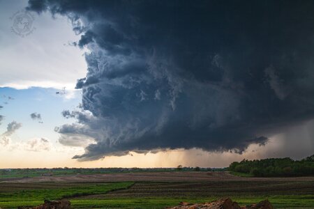
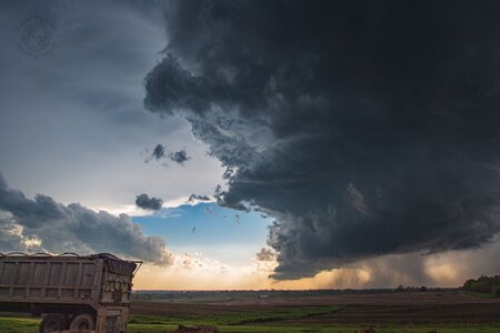
I had no intention of chasing this day due to work. I got off around 6pm and noticed a towering storm to my north. Imagine my surprise when I checked the radar to find a tornado warned supercell a half hour away! I rushed home, changed, grabbed my camera, and headed north. I went up US-283 to Blair, and then east on OK-19. This was my initial view as i came upon the storm just west of Roosevelt.

20240430_184600_edit.jpg

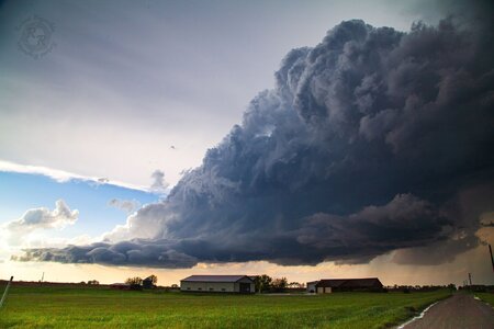
The storm was barely moving, and so I had all day to sit and take photos. I saw lots of vertical motion, and a little bit of low level rotation, but nothing crazy on this first cycle, though it was rather photogenic.

20240430_185258.jpg

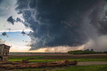
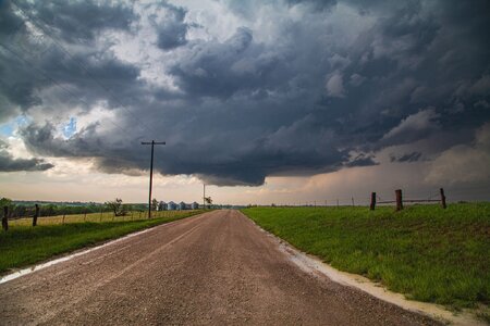
I pushed to the east as the storm cycled, and pulled off at the OK-19/US-183 intersection. This time the ragged wall cloud had some noticeable rotation.

20240430_191854_edit.jpg

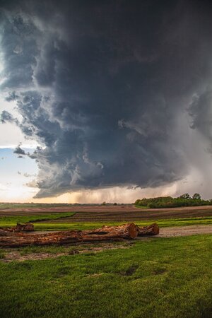
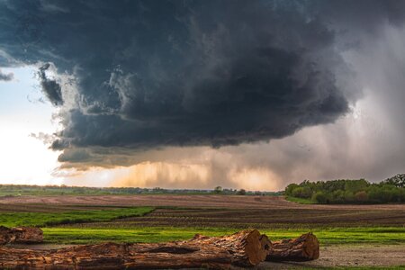
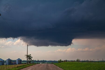
At this point the storm, while still nearly stationary, had taken on a sort of southward drift. As it cycled once again, I moved south on US-183 to stay ahead of it. I stopped after a few miles and saw the most vigorous rotation I had seen all day, as well as a tiny little danger noodle of a funnel.

20240430_193804_edit.jpg

20240430_194416.jpg

At this point, the storm's outflow was starting to push south, and I was close to being pinched into storms south of my position (the ones that would eventually go nuts near the KFDR radar later that night). I went ahead and took this opportunity to push the rest of the way south to Snyder. On the way I encountered some small quarter-ish sized hail and low end severe wind gusts. I also encountered this beautiful view of sunlit mammatus peaking out from between the 2 storms near Mountain Park.

20240430_200157.jpg

I turned west on US-62 to head for home, but not before stopping to photograph some more beautiful landscapes.

20240430_202724.jpg

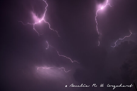
I was immediately west of Altus when another supercell briefly tried to get itself going, though it never quite succeeded. I still managed to get a view of its short lived inflow tail before the sun set for good.

20240430_205729.jpg

Despite not getting a tornado on this chase, I rank it as one of the most fun I've had. I got some great photos, and I will hopefully be uploading a video compilation of the 3 rotating wall clouds I saw soon. In my chase report from 27 April, I had lamented the fact that I always managed to find myself out of position. That was not the case on this chase. I got in front of the storm, and stayed there, backing up and adjusting based on what the storm was doing. Also, with how discrete this storm was for most of the time I was on it, how slow it was moving, and the minimal number of other chasers present, I was really able to see the storm structures and understand how things were working. I was able to take the time to notice the warm inflow at my back, and then notice the change to the cooler outflow in my face as the storm moved closer to me. I was able to notice how as the storm was about to cycle, the visible inflow bands weren't flowing into the part of the storm I was focused on, and instead into a new lowering. As cheesy as it may sound, I felt connected to Nature in a way I have never felt before during this chase, and I hope to have many more moments like that in the future. See y'all on the next one!
 
Last edited:
I wasn't expecting to chase at all on 30 April, and I only did so because I was encouraged by some more experienced friends. I was only expecting to see a bit of structure, but I was encouraged to leave the mammatus behind in Anadarko when the northernmost cell became warned for an observed tornado. Since the northernmost cell's inflow was about to be contaminated by another storm's outflow, I decided my chances were better if I dipped south to the Roosevelt storm. That storm ended up being the most beautiful, most photogenic storm I have ever seen.

IMG_5226.jpg

It was similar to a storm I saw near Guymon, Oklahoma on June 27, 2023. However, this storm was much more isolated and slow-moving, which allowed me to keep my timelapse rolling for over 30 minutes before I had to reposition. Near the end of the timelapse, the storm's inflow began to kick up a cloud of dust from the ground, and the dust highlighted a stream of horizontally rotating air under the inflow tail flowing into the updraft base. A funnel began to form near the end of the stream, but I had to leave it to reposition in a safer spot.


As the cell cycled, I picked a new spot south of Cooperton. Since road options in the area were limited, and my Honda Accord can't handle muddy roads, I decided to stay near Highway 54, which would let me escape to the south. The mesocyclone remained highly photogenic, but my timelapse was cut short by a surprise event.

IMG_5776.jpg

Even though I was 8 miles away from the hook of the cell to my north, a tornado had managed to form just across the road from me. Its ground circulation was clearly visible just over the hill to my west. This is my best attempt to represent where it was in relation to me when I first noticed it. I believe it to have somehow been caused by the left split either enhancing or creating an RFD-like feature in the area.

1714873873814.png

I spent the tornado's duration driving away from it. I was only able to see it as a curtain of solid dust in my rearview mirror. I briefly stopped the car to try to take a picture of it once I had gone a few miles south. By that time, all that was left was a column of rotating dust, accompanied by an extremely clear RFD cut.


After this, I decided to reposition to safety behind the line for the night. As the sun set, the cell near Altus began to produce frequent anvil crawlers. I was able to keep my camera rolling a timelapse for over an hour before the battery ran out.

IMG_6039.jpg
IMG_6165.jpg

Almost every single frame of the timelapse could've been a still of its own. I stood there in awe for the whole time, jaw dropping with each bolt that crawled across the ceiling of the sky. I was vaguely aware of the anticyclonic PDS-warned tornado happening at the time, but I was too awestruck by the storm in front of me to keep up with the anticyclonic tornado on radar. I've chased over 35 times in the past two years, but this chase is the most incredible I've ever had.
 

Attachments

  • IMG_5952.jpg
    IMG_5952.jpg
    106.9 KB · Views: 2
My best chase in a few years, as I managed to catch the Westmoreland EF-3 tornado, and then followed the supercell down Highway 24 to Topeka and Lawrence. Left Lawrence around 3:20 almost too late, as construction slowed me by about 10 minutes on the north side of Topeka. As I continued west on I-70, I decided to target the cell then developing north of Manhattan, rather than the healthier cells to the north. Figured they were in a similar environment, and that the southern one might eventually cut off the activity to the north. Plus it was just closer and easier to get to first. Turned north to Wamego, and once I was north of the town got a view of a healthy rain free base to my northwest. Didn't fully realize it at the time, but this was a developing updraft on the flank of the original cell. Didn't see any rotation or even wall cloud at first, but as the RFD began cutting in a small funnel quickly developed. Once this happened I found a good pull-off area on a hill (roughly 6-7 miles southeast of the cell) and stopped to watch. Within a couple minutes I could see a ground circulation, and the rest of the tornado quickly condensed following this.

800_9729.jpgDSC_7777.jpg

It stayed on the ground for approximately 10-11 minutes, and I was able to watch nearly the entire lifespan from this spot before I repositioned as it began to rope out. Each of these frames is approximately 2 minutes apart.
WestmorelandTorPanels.jpg

It became obvious that the parent storm was turning more to the ESE by this point, and worried about future development I bailed southeast to get away from a windy gravel road network and onto the ESE-running Highway 24. By the time I stopped again near Rossville, it had become a big HP.
800_9743.jpg
Continued following it along Highway 24 north of Topeka before crossing the Kansas River at Lecompton and getting on Highway 40 west of Lawrence. Saw a couple circulations wrap into the increasingly messy parent storm. The second of these around 6:55 might have been the beginning of the Williamstown EF-1 around 7:00.
800_9762.jpg800_9773.jpg
By this point the entire circulation was almost entirely rain-wrapped from my vantage and starting to weaken, and since I was only 10 minutes from home I decided this was a perfect time to call the chase. All in all it was a fairly easy chase all within an hour of home, and one of my best chases of the 2020s. Sad though to hear about the damage and fatality in Westmoreland, that does put a bit of a damper on the whole day.
 
Last edited:
Back
Top