2022-04-10 to -14 EVENT: KS/OK/MO

I'm not too big of a fan of the late timing and capping inversion being shown on Tuesday given the high gas prices, to take a gamble this early in the year. If Wednesday can slow down, I could see a significant severe event for much of Illinois and the Midwest. Even right now taking the 12z NAM at face value, there is definitely tornado potential in West Central IL early Wednesday afternoon with a strong cold front. Not seeing much for initiation until after dark on Tuesday. Given gas is 4.60 a gallon here, may stick locally...
 
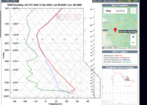
First 2 NAM runs to reach out that far are cap city for Tuesday except, rather ominously, over a small area of central OK.

Some global models showed, and continue to show, something similar with the best upper-level flow split and confined away from the best instability and hodographs. Today's 12z NAM3km still shows the cap winning at 00z on Wednesday. I still get the impression that the high CAPE plus dryline mixing and differential daytime heating will initiate and maintain at least one or two discrete updrafts, but with such a large warm sector oriented north-south I worry it will be a difficult chase for many.

That said, there is still a lot to like about this setup with the location, weekday timing, long-duration moisture return, sharp dryline, and storm motion nearly perpendicular to it. There's also the possibility that the questionable initiation ends up favoring more widely spaced storms which are easier to chase, although now it's looking like it could also introduce timing issues. Of course, there are also the issues with gas prices and car parts supply chains, and I wish all those chasing the best of target and breakdown/repair luck.
 
Since the analogs are showing the Wichita-Andover Outbreak day as #1, I thought some perspective on forecasting might be helpful. If I am providing too much info, just skip over this one.

I have written about what it was like to work that day. Story here: https://www.kansas.com/news/weather/article250870499.html This is a video interview, right below is the link to my story which is what I'd most like you to read.

1991 was long before mesoscale or convection allowing models, yet we (ICT TV stations, NWS, IAB meteorologists, etc.) were telling the people of south central Kansas about the major tornado risk four days in advance. Just like now, we were worried about the CAP and everything else that could go wrong. NSSFC correctly posted only the second-ever "particularly dangerous situation" tornado watch after posting a "high risk" in their convective outlooks.

What we did to make that series of 1991 forecasts is pertinent to today.
  • We spent a lot of time on analysis, especially once the short wave crossed the Pacific coast. In the current case, that should be this evening. One thing we did is compare the IR and, if I recall correctly, water vapor satellite imagery to our analysis. My sense is that not enough of that is being taught today.
  • We saw that the 250mb jet on the backside was going cause the short wave to dig and that the out of phase isotherms at 500mb were going to cause the trough to strengthen.
  • After we got our preliminary thoughts by doing the above, we looked at the models. They confirmed those impressions which increased our confidence. My opinion is that it is important to look at the models last.
  • Did we worry about the CAP and the position of the dry line? Of course! But our goal was give the user the best possible forecast regardless of what the models might say.
  • Some of the models in the current situation have shown some rain in the region Tuesday morning. If so, that is favorable for tornadoes. It causes the LCL to drop due to evaporation. There were extensive thunderstorms near dawn on 4/26/91 with a damaging tornado near Tonkawa and very large hail in Kay County. These may also increase the chances for tornadoes by creating small boundaries that "bake" during the late morning and early afternoon.
When it comes time to nowcast when we get just a few hours from the event, frequent surface charts and comparisons to satellite and the SPC tools are great resources. Then look at the CAMs. I'm hoping we'll get an 18Z sounding from KLMN to compare to the CAMs Tuesday.

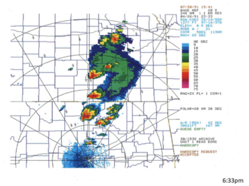
Nearby is the 6:33p CDT NEXRAD image. Unfortunately, the WSR-57's images (B&W) were of poor quality. Even though the OKC NEXRAD was quite a distance from the outbreak, it will give you an idea of the spacing between the supercells that late afternoon and evening. Be very careful if you go out Tuesday because the cells will be moving ~40kt with at least some rain between cells causing at least minor visibility issues. Every one of these supercells was producing a tornado at this point!

To quote Sargent Phil Esterhaus from the great television show Hill Street Blues: "Let's be very careful out there!"
633p radar 4-26-91.png
 
Was seriously considering flying out for this event, but there are too many monkey wrenches to push me over the top. The showtime placement of the dryline is always an issue, especially with some very low soil moisture figures in the region. Capping, along with storms possibly maturing in the jungles east of I-35. My main concern for tomorrow would be OKC and Tulsa areas if something does go. I would likely set-up in OKC if I was chasing and use I-35 to stay put, or go north if ICT looks good in the AM.
 
I view Tue. 4/12 as a moderately impressive, conditional early season opportunity. If everything breaks our way, there could be a few tornadic supercells dispersed widely across the DFW-MCI I-35 corridor before dark. I definitely don't see the ceiling for this event being in the same galaxy as 4/26/91, though. That event had much better moisture quality, not to mention an absolutely textbook, negatively-tilted, well-timed trough ejection. Plus, 0-6 km bulk shear for Tue. looks on the order of 30-40 kt south to 40-50 kt north, a far cry from 1991. Overlaying these deficiencies, it becomes difficult to envision anything like a violent outbreak. There are plenty of substantive differences, but I'm picturing something more like 5/1/08 (samples: KS, NE OK, C OK) as a reasonable "goal" for the outcome here.

Assuming we manage robust CI by 4-6pm, I can see isolated supercells that are initially nontornadic or weakly tornadic, with 1-2 perhaps becoming more substantially tornadic in the early evening as they move into lower LCLs (provided they can overcome moderate CINH dynamically). But, a daytime cap bust remains quite possible outside of TX, where shear is pedestrian. Given these contingencies, I don't love the fact that we're waiting for moisture that will need to traverse severely drought-stricken TX, or that the dryline itself will reside mainly over drought-afflicted areas.
 
Yeah, a little earlier in the forecast cycle I was thinking that Tuesday in particular had a 4/26/91 or 3/13/90 type ceiling, but as we get closer something just seems off about it, particularly timing of the trough ejection. It's too late for peak heating Tuesday, and too early for Wednesday.

That said, thanks @Mike Smith for that analysis of 4/26/91. I've always been rather fascinated by that event since it was THE recent significant tornado event of record when I was becoming a kid "weather nerd" in the '90s, heavily featured in TV documentaries like TWC's Enemy Wind and written about by all the giants of meteorology and chasing such as Tom Grazulis, Howard Bluestein and @Warren Faidley . Indeed, too bad the KICT NEXRAD didn't exist at the time!
 
I view Tue. 4/12 as a moderately impressive, conditional early season opportunity. If everything breaks our way, there could be a few tornadic supercells dispersed widely across the DFW-MCI I-35 corridor before dark. I definitely don't see the ceiling for this event being in the same galaxy as 4/26/91, though. That event had much better moisture quality, not to mention an absolutely textbook, negatively-tilted, well-timed trough ejection. Plus, 0-6 km bulk shear for Tue. looks on the order of 30-40 kt south to 40-50 kt north, a far cry from 1991. Overlaying these deficiencies, it becomes difficult to envision anything like a violent outbreak. There are plenty of substantive differences, but I'm picturing something more like 5/1/08 (samples: KS, NE OK, C OK) as a reasonable "goal" for the outcome here.

Assuming we manage robust CI by 4-6pm, I can see isolated supercells that are initially nontornadic or weakly tornadic, with 1-2 perhaps becoming more substantially tornadic in the early evening as they move into lower LCLs (provided they can overcome moderate CINH dynamically). But, a daytime cap bust remains quite possible outside of TX, where shear is pedestrian. Given these contingencies, I don't love the fact that we're waiting for moisture that will need to traverse severely drought-stricken TX, or that the dryline itself will reside mainly over drought-afflicted areas.

Quite agree with this. We don't have the upper level support well timed for a major outbreak.

That said, should the cap go, and should we get the surface environment some of the models are depicting, I think we've got a great shot at some impressive tornadic supercells. Strong tornadoes would look possible, especially as we approach nightfall and the LLJ kicks in. The hodos near 0z +/- 3 look really impressive. The strength of this setup seems to be the impressive quality of shear at the lower through (near) mid levels; turning with height looks ideal. Should things come together, I could see 10-15% hatched from SPC.

(Edits: will say that the shear is more impressive further north towards i70 than down into OK and southward. Much of my analysis here was looking at the northern target. Also included hodo depicting quality of shear W of Topeka at 0z)

Also... as the main wave of upper level support noses into the region later in the evening, any cells still ticking will get a nice boost. Strong tornadoes after dark look possible, especially with discrete storms.

1649628447239.png
 
Last edited:
I'm not too big of a fan of the late timing and capping inversion being shown on Tuesday given the high gas prices, to take a gamble this early in the year. If Wednesday can slow down, I could see a significant severe event for much of Illinois and the Midwest. Even right now taking the 12z NAM at face value, there is definitely tornado potential in West Central IL early Wednesday afternoon with a strong cold front. Not seeing much for initiation until after dark on Tuesday. Given gas is 4.60 a gallon here, may stick locally...
So I am just perusing the models right now, and I am not as good at it as many on here so correct me if I am wrong. This will be a local chase for me so, and I plan to get to work early Tuesday to allow me to get off early and get into position.

NAM shows dewpoints 62 to 65 to near Omaha. The ECMWF shows what appears to be excellent shear moving in near or after dark in the area of NE KS, NW Mo, SW Iowa, SE NE. As mentioned previously the best Cape appears to be located further to the south displaced from the best shear. All of that being said it appears other parameters are high enough to overcome some of the short comings in this setup. I won't beat it to death as others have covered them well.
 
Like Warren, Andy, Brett and Derek, I am not that bullish about this event. I share Warren’s concern about where the dryline sets up in OK and storms heading off into the jungles of eastern OK. I have a similar concern about eastern KS, which is better terrain than E OK but still contains many areas that are far from ideal chase territory in my opinion. Fast storm motions make the quality of the chase terrain even more important. The surface winds are not backed in KS or OK. There does not appear to be much turning with height - the wind profile is almost unidirectional from 850mb up. The hodographs do not look great to me. If I were out there, I might actually take a chance in Iowa near the warm front, where surface winds are more backed and the chase terrain is better. FWIW, should the Euro does not show the dryline with the same idyllic sharpness that the GFS does. Not saying there won’t be some great tornadic supercells, but I don’t think it’s going to be a huge event or anything worth a special trip from the coasts. But maybe it’s just my confirmation bias - since I can’t chase anyway, I would rather feel like I’m not missing anything.
 
Well after going over todays and now tonights Model runs I have several things to point out from my perspective. First tomorrow looks like a potentially legit severe/tornado outbreak over the western half of Arkansas possible even parts of extreme southern MO. Been watching this trend in models all day long. Looks spooky from about 6pm through 11pm in the jungles. Second I am becoming more and more concerned that the Oklahoma and Kansas play for tuesday my not materialize not just due in part to capping but several factors, the lack of stronger convergence along the dryline, ill timed wave, lack of stronger flow above 500mb, and the subtropical wave moving across texas during the day. However my eyes have been slowly peeking more and more up towards central Iowa especially after seeing the 00z Run of the HRRR. If trends continue tonight and tomorrow in guidance with the Iowa play watch out up there some serious tornadic ingredients in play up there along the boundary with a surface low nearby. Strong instability, warm front, excelent low level shear and strong flow aloft. Dew points in the Mid 60s. Have to seriously watch trends next 12 to 24 hours but tomorrow could seriously end up being the big day just sucks its in a horrible if not some of the worst chase terrain.
 
I have spent surprisingly little time in Iowa in my 20+ years of chasing, but it is without a doubt better terrain than E OK. I have never been a fan of much of E KS either, but I know others disagree. The US Chase Map US Chase Map Project shows most of western Iowa, and the northern two-thirds of it, is at least comparable to E KS. I think Iowa could emerge as the better choice on Tuesday when both the parameters and the chase terrain are considered. Both the Euro and GFS appear to bring the warm front and 60+ dews into the northern half of the state.
 
I'm likely sticking close to DFW for this one unless something drastically changes in the Oklahoma portion of the setup. Too much uncertainty for me to cut out of work early this time of year.

Last night's 00Z NAM was reasonably bullish on moisture depth along the dryline for the Texas portion of this setup, with mid to upper 60s dewpoints spread along the US 287 corridor by mid-afternoon. That coincides with a ribbon of >3000 j/kg of MLCAPE running north along the edge of the dryline into OK. The N Texas I-35 corridor looks like it's only going to receive a glancing blow of forcing before 00Z from this trough per the Euro and NAM along with the cap strengthening a bit between 18Z and 21Z tomorrow.

That said, it looks like any sort of luck with regards to forcing/a deep dryline circulation could set off an isolated supercell or two should the cap become manageable a few hours before sunset. The westerly 500s are a nice bonus this far south along with the potential for some slow storm motions should any go up. Put a prayer up for your windshields tonight in case anything goes tomorrow.
 
I wish I had any confidence in the warm front booming as far north tomorrow into northern Iowa as the HRRR wants it to. This would go from an arm chair to something semi-local for us up here. Unfortunately the daylight window for this to happen is short and the storm motions ridiculous. All other 12z short range guidance is much further south with the warm sector and not sanguine with storm coverage. As others have stated timing is off with just about everything for tomorrow and things don't line up until the overnight hours. Wednesday is another story.

I'm tending pessimistic, what a downer from a system that had so much promise. But it's certainly too early to throw in the towel.
 
Feel like the SPC is validating what I was seeing with the northern target and its potential for strong tornadoes given some of the simulated hodographs and impressive SRH figures being suggested. (everything just moved NE a bit -- only the extreme northern portion of DL seems to be in play)

What I didn't pick up on was the moisture return so far into IA/NE. SPC seems to agree with the HRRR here.

Being from Iowa City, IA, this has become a rather easy decision to chase for me. I'll probably head out towards Omaha tonight and adjust in the morning. Hope I can avoid Missouri river crossings... but get the feeling I may end up pulled west.
 
Derek, I was just about to post similarly, SPC removed the 10% tornado risk from everywhere but Iowa (and some small portions of adjacent states) in the 17:30 Day 2. I haven’t even looked at the HRRR yet but even the GFS and Euro had the moisture getting into the northern half of Iowa.
 
Back
Top