2021-07-28 event MN WI MI

Todd Lemery

Staff member
Supporter
Joined
Jun 2, 2014
Messages
844
Location
Menominee, MI
I’ve been watching this fairly closely since it’s in my backyard. If this was a low cape, high shear event in somewhere other than Wisconsin, I’d be a little more enthused. There’s a chance for a semi-discreet supercell or two to slide through one of the few low tree density areas that the SPC Currently has pegged for a 10% tornado risk. I pulled a couple of soundings from West Central Wisconsin with nice curved hodos which is nice to see. The storms will be moving along at a pretty decent clip so with the crappy road network you’ll never keep up once it gets by you.
That said, I’ll watch from home and will head out if/when anything starts looking a little promising. a successful chase today will probably be seeing good structure.
Oddly… there’s a better than good chance for a “chase day” over here in NJ as well tomorrow if I’m looking at the SPC SWODY2 correctly (essentially being an extension of everything going on in the target area today / tonight)… this all just got pretty interesting
 
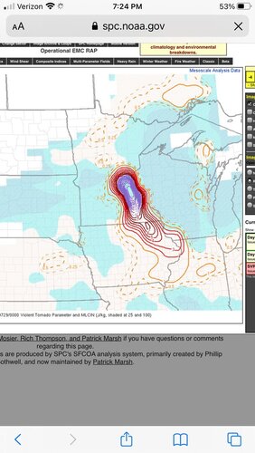
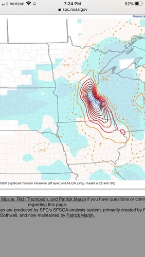
I'm not sure exactly what kept this set up from fully meeting expectations. The parameters west of the warm front were off the charts. I don't know if it was a capping issue or what. I know the 12C H7 contour was farther into WI than we expected. That might partially explain it. There were also a lot of clouds during the day that kept heating from being as strong as the models suggested. Still, there should have been plenty of instability to tap into. I watched radar all night since this was all just to my east and northeast and the updrafts never seemed to be able to sustain themselves. One scan the VIL and echo tops would max out suggesting the storms finally broke the cap but a scan or two later it would start to fall apart. Another part of it may be there wasn't much low level instability. Mesoanalysis showed almost no 0-3km CAPE.

For reference of the crazy parameters, a screenshot of the SPC mesoanalysis STP and VTP are attached. Off the charts is an understatement. Having said that, usually when we see these kinds of numbers it means the atmosphere is solidly capped.
 

Attachments

  • 072821 STP.jpg
    072821 STP.jpg
    142.8 KB · Views: 2
  • 072821 VTP.jpg
    072821 VTP.jpg
    147.5 KB · Views: 2
I expected a denser concentration of wind reports (basically solid blue on the SPC map) and more sig wind reports further north in WI. Instead of a classic derecho with an intense rear-inflow jet as expected, it seemed like what we got was a loosely-connected line of southeastward-moving HP supercells. They produced a cluster of weak (EF0-1, but one was on the ground for almost 13 miles) tornadoes in southern Wisconsin around 1 AM Thursday, near the 10%/5% border on the southern end of the SPC's risk area.

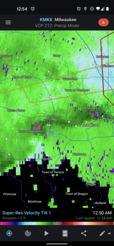
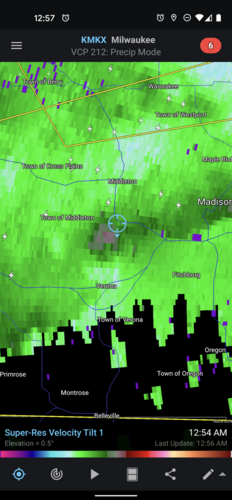
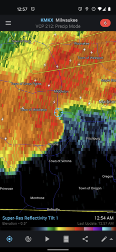
I was awakened by the sirens (there's one right outside my apartment building in far southwestern Wisconsin) a little after 12:50 AM. I immediately pulled up Radarscope and saw that we were outside of the tornado warning polygon then in effect for other parts of Dane County, but what appeared to be an embedded supercell on reflectivity had a modest couplet on velocity that was passing just to our southwest (blue crosshair is my location). There is some minor damage from near Cross Plains that they are surveying today.

Screenshot_20210729-005417.pngScreenshot_20210729-005713.pngScreenshot_20210729-005723.png
 
Back
Top