This day's target seemed rather simple, though I admit I was not paying as much attention as needed to the remnant outflow from last night's storms. All eyes were on the surface low and the cumulus field focused at Tribune, where the first storm (and the day's apparent target storm, at the time) fired by 1PM (much earlier than I'd prefer). I made it to the storm at Leoti and watched as it attempted several wall clouds that all got obliterated by outflow just as they were looking good.
As I moved east to stay with this storm's updraft, I discovered that *all* of the secondary roads in the area were very sketchy (lots of partially-muddy sections). I made it two miles east of Highway 25 on them before saying "no way" and heading back west to the highway. There were no other paved roads to easily stay with the Leoti storm, with Highway 83 being the closest at 25 miles distant. Not an impossible task, but now I was seeing the tornado reports from the storm up near I-70, 40 miles away. Those storms didn't look very beefy on radar, but since they were producing so quickly, it was evident they had some sort of boundary to work with up there. They were only 40 miles to the north, and would take about the same time to catch up to as the Leoti storm again. So, I ditched the Leoti storm, heading north on Highway 25 through its core.
I had another mud road scare on this drive north. GPS shows Highway 25 as continuing paved straight north to Highway 40 west of Winona. What the maps don't show is that where Highway 25 turns east to Russell Springs, the 65mph paved road north suddenly goes to 45mph, starts down an incline that hides what's ahead, then turns to mud just past the intersection! I saw it in time, slowing to 25mph before hitting it, sliding to a stop, and reversing out. The tire tracks showed that many drivers before me had not been so fortunate - with several tire track ruts leading into the ditches. No one was stuck there, so they'd either been pulled out already or had sufficient 4WD and mud tires to get themselves out.
Continuing north on Highway 25, west on Highway 40 then north on Highway 83, I was now on the new storm east of Colby that had reportedly produced tornadoes already. It appeared to be on a downward trend though, with a cold linear look to it. A funnel soon appeared under this grunge, giving me some hope it could still have potential.
Again, the secondary roads in this area were absolute no-gos, completely saturated, rutted mud - so it was paved-roads-only for this storm. Thankfully, Highway 83's east-northeast orientation perfectly matched the storm's track.
At Rexford, I stopped ahead of the storm to watch it approach. At this point, the storm was rapidly intensifying both visually and on radar. What had been a lazy shelf cloud extending to the north now became a tail cloud racing into the new meso with ever-increasing speed.
A RFD clear slot developed and began cutting in - and it looked like we were in business.
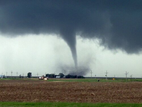
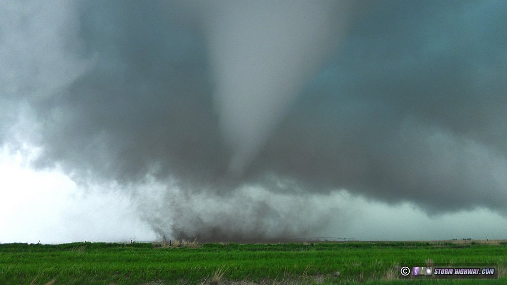
I moved up to where the RFD was carving around just north of Rexford, and had time to tripod a shot of the classic tornado spinning up horizontally, then being pulled vertical before quickly wrapping in rain:
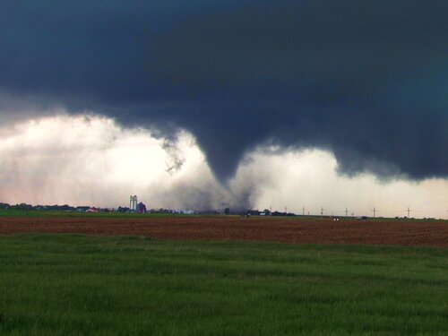
The new meso was quickly taking shape to the east, with a much stronger RFD surge that passed overhead only a minute after I stopped to watch again a short distance down a dirt road between Rexford and Selden. The new tornado developed quickly.
After it crossed my road to the north, I got back on Highway 83, pacing the tornado as it moved east.
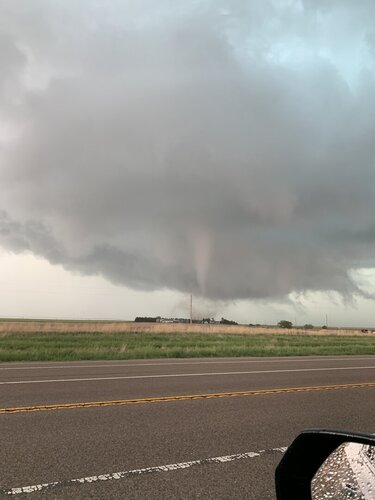
Soon, it appeared the tornado was approaching the highway and would cross it. I stopped just behind where I thought this would happen, watching the tornado pass by just to my north with its "waterfall" sound audible, zoomed out all the way on the video camera:
Instead of crossing the road, though, the tornado tracked right along it, with an occasional subvortex swinging out into the road.
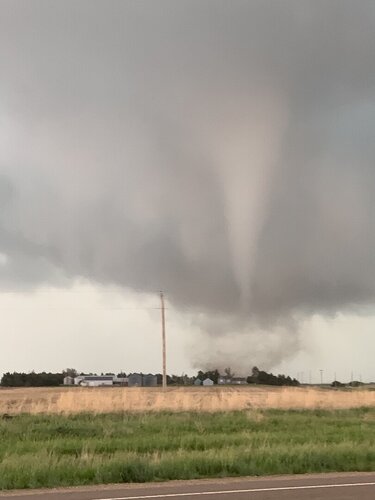
The tornado remained uncondensed for much of the second half of its life, aside from one dramatic fully-condensed stage where the collar cloud began filling in briefly:
The tornado entered the north side of Selden, with at least two subvortices and possibly a satellite far removed from the main tornado farther south, with periodic bursts of debris lofting and multiple roofs flying:
Although the tornado was clearly passing through the town, the small amount of debris was not indicative of a violent tornado doing significant damage - thankfully Selden appeared to be avoiding the worst.
I stopped here to ensure that the flying debris risk in town was past, then continued east just behind the tornado, making my closest approaches to it here twice (and retreating twice).
Hail in the strong RFD followed just behind the tornado, so I didn't have much room between the two. Finally, seeing that the tornado was wrapping in rain, I used Highway 23 to duck out of the way of the RFD hail threat and continue east farther away from the storm. As I did this, rapid rising motion on the RFD gust front appeared to be focusing a new circulation just ahead, but never came close to producing anything.
I stopped again along Highway 9 to watch the meso pass by to the north. The RFD gust front had an anticyclonically-rotating updraft column just behind it and nearly overhead.
After this, the storm lost strength both visually and on radar, so I began heading east toward Lenora for lightning from some new storms to the east. As I made this drive, the Selden storm vanished completely.
The lightning from the Lenora storm ended up not being sufficient quality for high speed, so I continued south to I-70, meeting the original Leoti storm as it slowly shriveled to nothing as it approached the highway at WaKeeney. I headed east, once again stopping in Hays for the night.
Video: