Hannah.Taylor
EF4
First off, BIG thanks to Bob Schafer for yesterday's chase. Secondly, BIG thanks to Mother Nature for showing up putting on one hell of a show starting at 3:53 pm in Holly, CO and all the way back to Coolidge, KS on the return leg with an amazing artillery lightning show. Yesterday was quite the spectacle. While I didn't fare as well as others in terms of photography results, I saw EVERYTHING except a tornado on the ground. I saw funnels, I saw rotating wall clouds, stationary wall clouds, hail, intense, frequent and unbelievable cloud to cloud lighting and cloud to ground lighting, insane inflow, spaceships and some amazing structure. It doesn't get much better than yesterday.
WOW!
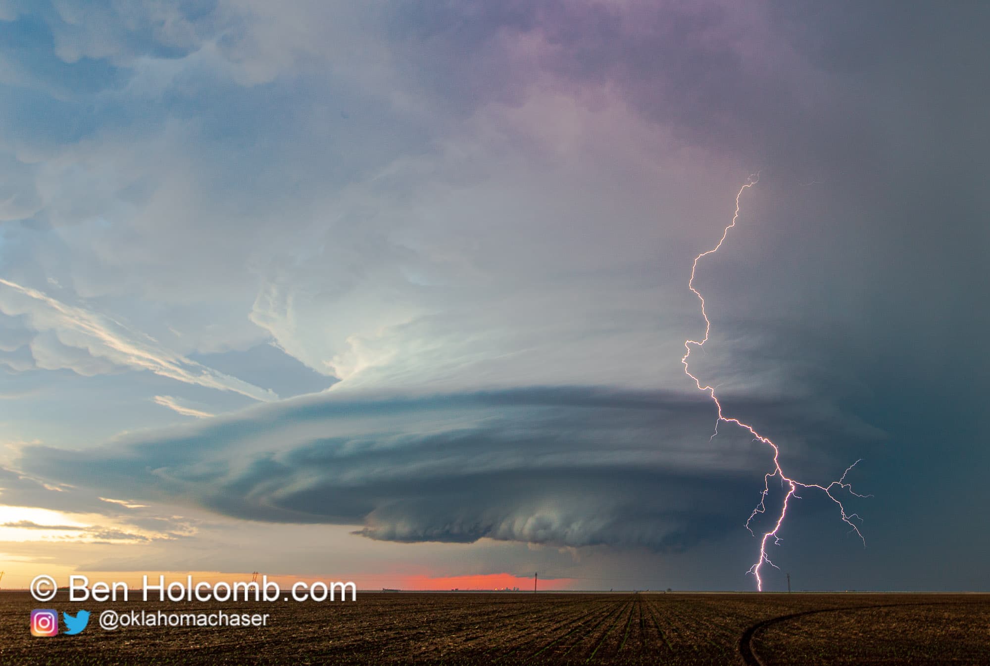
I rendezvouzed with Bob Schafer in Holly, CO around 3:53 pm and immediately a storm was in progress and tornado warned. We followed it through Coolidge, KS and Syracuse, KS stopping several times to watch it cycle.
Holly, CO

Holly, CO

Syracuse, KS

In Deerfield, Bob turned South and went for home. I continued chasing. After consulting the radar, it appeared everything to my direct west was going linear, so I dropped down towards Sublette to one of two discrete cells, the other was in Moscow/Satanta. I chose the cell directly to my south. A beautiful floating spaceship right above KS-83.


Sublette storm in the center, Moscow storm on the right.

I passed the Dopplar radar station on the right hand side of the road, and pulled off onto a dirt road with a power station there. As I did, crazy inflow got going being sucked into the Moscow storm (at the time I thought it was the Sublette storm, but I later realized that wasn't correct). I was at least 30 miles away from the Moscow storm. In the process of filming the inflow I temporarily lost my hat but was able to run it down. I then went down to KS-144 and went east trying to get out ahead of the Sublette storm but much to my chagrin, it lost it's intensity, structure and fell apart.
Just north of Copeland, KS

Just North of Copeland, KS

By that time it was dark so stupidly, I called the chase. I haven't had much experience with chasing after sundown and my comfort level is iffy and I was by myself. Despite that I had the hunch I should go back to the Moscow storm but pushed it out of my mind and headed for home. Big mistake. The pictures I saw coming in on Twitter later were unbeliveable and amazing. I kicked myself in the shin all the way back to Colorado. Still a big day and a fun one. Congratulations to everyone else who got the amazing structure in their photographs.
I need to upload videos of the inflow near Sublette and the wall cloud in Holly but I'll have to get to those later this evening.
WOW!
I rendezvouzed with Bob Schafer in Holly, CO around 3:53 pm and immediately a storm was in progress and tornado warned. We followed it through Coolidge, KS and Syracuse, KS stopping several times to watch it cycle.
Holly, CO
Holly, CO
Syracuse, KS
In Deerfield, Bob turned South and went for home. I continued chasing. After consulting the radar, it appeared everything to my direct west was going linear, so I dropped down towards Sublette to one of two discrete cells, the other was in Moscow/Satanta. I chose the cell directly to my south. A beautiful floating spaceship right above KS-83.
Sublette storm in the center, Moscow storm on the right.
I passed the Dopplar radar station on the right hand side of the road, and pulled off onto a dirt road with a power station there. As I did, crazy inflow got going being sucked into the Moscow storm (at the time I thought it was the Sublette storm, but I later realized that wasn't correct). I was at least 30 miles away from the Moscow storm. In the process of filming the inflow I temporarily lost my hat but was able to run it down. I then went down to KS-144 and went east trying to get out ahead of the Sublette storm but much to my chagrin, it lost it's intensity, structure and fell apart.
Just north of Copeland, KS
Just North of Copeland, KS
By that time it was dark so stupidly, I called the chase. I haven't had much experience with chasing after sundown and my comfort level is iffy and I was by myself. Despite that I had the hunch I should go back to the Moscow storm but pushed it out of my mind and headed for home. Big mistake. The pictures I saw coming in on Twitter later were unbeliveable and amazing. I kicked myself in the shin all the way back to Colorado. Still a big day and a fun one. Congratulations to everyone else who got the amazing structure in their photographs.
I need to upload videos of the inflow near Sublette and the wall cloud in Holly but I'll have to get to those later this evening.