2020-03-28 EVENT: IA/IL/MO/WI/IN/TN/AL

Jesse Risley

Staff member
Joined
Apr 12, 2006
Messages
2,266
Location
Macomb, IL
Though it's still a bit out in the extended time period, I've been keeping an eye on the trough that traverses across the middle CONUS and transitions out of its positive phase by FRI night - SAT morning.

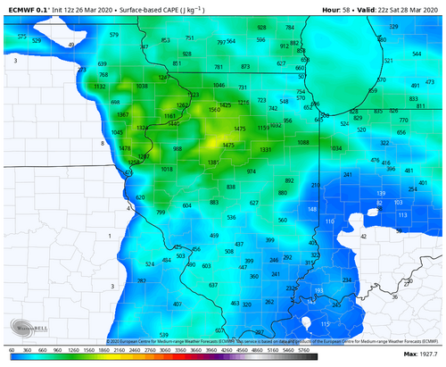
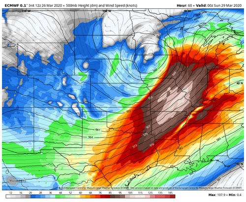
A low pressure over SC KS is progged to deepen and move into NE IA or NW WI/far E MN, depending on whether you consult the ECMWF or the GFS, as the trough deepens that the mid-level jet core begins to approach the lower Missouri River valley by 12z/28. As of right now a warm frontal boundary is poised to be positioned somewhere between US 34 and US 20, extending eastward across IA and into IL. Shear profiles support the development of supercells, with seasonably ample lapse rates, MLCAPE values AOA 1000 J/KG and SRH profiles generally between 100-250 m2**s2 INVO of the warm front and closer to the triple point. The extent of instability in the archetypal warm sector is still yet-to-be-determined, though peeking at H85-H7 RH values and what products are available on the GFS, there may be a regionally narrow corridor of sufficient atmospheric instability, synchronous with what is also showing up on some of the ECMWF soundings, from EC IA into far E MO and C IL, for all modes of severe weather, particularly if storms do materialize and stay discrete. There are definitely favorable profiles in the lowest 1km on the 12z/25 ECMWF for rotating updrafts. Given that we are still 96+ hrs out storm mode and the extend of atmospheric instability in the warm sector remains to be determined, but this could be the first appreciable severe weather event for the central Corn Belt if things materialize properly.
 
I am not sure If I have the standing yet to participate in the formal target area discussions on the forum (so please correct me if I should not), but I think you should include IN in the target area discussion. There are ample dews, and the best shear appears to be centered over the northern halves of both IL and IN. GFS has the setup positioned over IN by 21z, while NAM lags to the west. Finally, per GFS, there appears to be a plume of LLLR reaching towards northern IN, which leads me to believe that there is a source for initiation. I agree its still early, but I think there is reasonable case for IN. (Plus I just want a reasonable excuse to get out and spot while still adhering to the shelter in place.) Thanks.
 
At least we're in range of the NAM, which is, however, much more progressive than both the GFS and the ECMWF with both the timing and placement of major synoptic features. The GFS also has some warm sector convective activity across the lower Mississippi Valley INVO of eastern edge of mid-level diffluence ahead of the main surface front where higher moisture presence will exist due to its proximity to the GOM; skew-T profiles definitely show atmospheric dynamics mainly favor the standard severe wind and hail thresholds.

Right now the northern target area will depend on whether or not the NAM or the GFS/ECMWF solutions are closer to reality depending on placement of the surface front and low pressure systems, which then makes the threat of severe weather in IA and WI mostly dubious. There's also a deceptively evident secondary cold core target closer to the main surface low, as H5 temps AOB -20C will overspread a narrow stream of moisture leading up to the triple point where models are showing favorable lapse rates IF surface heating occurs. It still looks like a fairly stalwart, fast forcing/frontal progression with wind profiles becoming more unidirectional with height, though there are some decent looking profiles in the lowest 1km with classic critical angle thresholds for ample streamwise vorticity associated with SRH at the surface. The actual warms sector itself is also progged to remain regionally relatively narrow based on all of the 0z/26 model data, but those instability parameters are more than sufficient for an early spring setup.
 
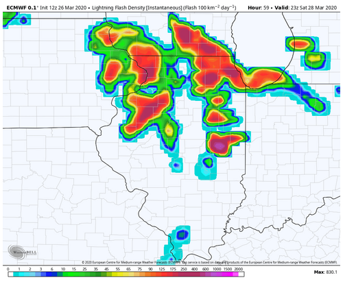
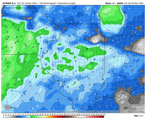
The ECMWF continues to advertise the most high-end solution when it comes to a more chaser-friendly, robust severe weather and tornado risk across the state of Illinois on Saturday. Keeps surface winds south/southeasterly across the entire warm sector through 0z, features a true dryline (rare this far east) and an uncapped warm sector with multiple waves of storms (supercells?).

Plenty to dislike about the setup from fast storm motions to a potentially very small warm sector. Those two ingredients alone remind me of a lot of March and early April setups that did not go very well.

That said, there's a lot to dislike about regular life these days so a fleeting glimpse at some convection sounds like a fine Saturday. I'll let any tornado threat that materializes be a little bonus for me.

FWIW, this is also a local event on my end. The best play on a day like this is to find yourself a nice north-south oriented highway, let the storms develop and mature and pick your storm of the day. You're going to get one, maybe two passes and nothing more. I'll have the vehicle set with supplies so that I'm not stopping, but this feels like a day I'll be back home in Champaign-Urbana by 6 PM. This feels like an event that peaks between 18z-22z.

ecmwf-deterministic-illinois-cape-5432800.pngecmwf-deterministic-illinois-lightning_density_inst-5436400.pngecmwf-deterministic-illinois-wnd10m_stream_mph-5432800.pngecmwf-deterministic-central-z500_speed-5440000.png
 
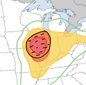
This is an outlook I threw together after checking out the 00z NAM this evening. The green line isn’t a thunder line, it’s the edge of the marginal risk, but I didn‘t have the energy to fill it in since the program isn’t very efficient to do so:

C001204A-3D27-4B8B-B158-8CE0B1E9B446.jpeg

The hatched risk I have is for all severe hazards: tornadoes, wind, and hail.

I really think this is going to be a significant event, especially in the northern half of my designated moderate risk. Low-level shear looks very favorable for tornadogenesis. Hodographs near the warm front/triple point have a nearly classic curve, and STPs exceed 7 in some spots. We’ll need to watch LCL heights though.

The NAM has a line of supercells along the front maturing near the MS River during the mid/late afternoon. Being this far out, the look to the storms on the CAMs are very impressive. The NAM also has some dry air in the mid-levels, so we may see some destructive straight-line winds also considering how much shear will be available.

I have the slight risk extended east to cover a hail threat associated with elevated convection in the morning/early afternoon hours. But the slight risk east to about Toledo (NW Ohio) will have to watch for a wind/isolated tornado threat into the overnight hours along the cold front.
 
There is some model consensus on a storm or two south of I-72 in the southeast quadrant of the system. I'm usually not a fan of being south of the apex of the cold frontal arc, and we won't have the backed low levels and benefit of a warm front down here. But with 200+ 0-1km SRH, good mid-level lapse rates and slightly more manageable storm speeds from being outside of the main jet core, there should be enough of a chance for a respectable tail-end supercell this far south that we might get a little more than 15 minutes to observe before it races past.. At least enough to make having to sit out the northern target per shelter-in-place orders more tolerable.
 
Just taking a glance at the 0z/27 data that is coming in, though the ECMWF is not out yet, these are some ostensibly high 3km CAPE profiles being advertised on some of the forecast soundings, coupled with very favorable LCLs, generous lapse rates and LIs indicative of a quite unstable troposphere. What is unusual for this type of setup, as @Andrew Pritchard noted in a previous post, is that we don't usually see a triple point this far east that comes from a non-diurnal MRV dryline (*or pacific trough - there's some debate going on over this). *However, the three hallmarks of Hoch and Markowski relative to MRV dryline scenarios seems to fit here, even if the source of airmass isn't a cT airmass from the Intermontane Plateau region, i.e., a requisite humidity gradient between the eastern and western components of the boundary, a requisite shift in wind direction between 50 km east and 50 km west of the line (180 degrees ahead of the boundary and 231 degrees immediately west of the boundary), and a quiescently narrow temperature gradient across the boundary.

There's enough instability in the warm sector of that golden triangle to throw down tornadoes with this, though in these setups sometimes the most potent tornadoes have actually emanated from storms that fired off of the main forcing mechanism in the open warm sector and not always a storm right on the warm front, though that needs to be watched too. A caveat is that storms could quickly outrun the warm sector, giving that storm motions will be fast, and also, as previously noted, CAMs are wanting to transition this episode to linear mode rather quickly. That having been said, if storms can continue to take advantage of favorable vertical shear profiles mesovortex tornadoes will remain an ambient threat well after the convection transitions to more of a QLCS or line segments. Other modes of severe weather remain concerns too, particularly large hail with early day convection.
 
The HRRR and the RAP have been insistent on a respectable environment overnight into the morning hours from St. Louis to I-72 in advance of the main wave, thanks to what appears to be a subtle shortwave embedded in the midlevel jet. Both of those models show the warm front surging north during this time with convective precip/supercells traversing the boundary, with 0-1km SRH spiking past 300 along and south of the front. The NAM and NAM NEST don't fire much convective precip during this time, though they do pick up on the potent environment in place. Providing the boundary layer doesn't decouple too much after sunset, this activity may be something to watch. The problem with this early activity is that if it is robust enough, it might bring subsidence/interfere with insolation for the main event later in the day.
 
The 12z HRRR is downright scary with the parameters in exhibits, showing potential for long-track, violent tornadoes.

Very favorable LCLs, 0-1 km SRH of 400+ m2/s2 in the vicinity of the warm front, deeply curved hodographs, bulk shear of 70-80+ kts, MLCAPE of 2500-3000 J/kg aided by steep mid-level lapse rates nearing -8 C/km, and substantial CAPE in the low-levels. All of this is yielding supercell composites of 20-30 and STPs of 6+

Should these trends continue, honestly a high risk would be possible, not only for the tornadoes but also potential for giant hail with those steep lapse rates and destructive wind with some dry-air aloft and ample surface-based CAPE.
 
Doesn't the SPC consider storm motion as a potential factor for high risk? Every sounding I look at has 60-65 kts of speed for right movers. Anyone else think these will be moving at 60+ mph?
 
The fact that the storms will be moving so fast could “surprise“ some people, even though this will be a well-warned event. I’m not sure if they take that into considering but on a day where the environment is so favorable, they really should. I’d expect storm motions around 60 MPH
 
Doesn't the SPC consider storm motion as a potential factor for high risk? Every sounding I look at has 60-65 kts of speed for right movers. Anyone else think these will be moving at 60+ mph?

This could get upgraded. I've seen some concerns about whether or not moisture parameters will be realized to the extent that models are depicting. Models are trending more and more towards a SIG SVR weather event across the area, especially on 12z/27 data (HRRR, NAM). The ECMWF isn't out yet. Of particular note is the 3km CAPE profiles with all of the vertical and horizontal shear present across the risk area, coupled with the fact that storms are progged to fire off of a MRV dryline or pacific trough instead of a crashing cold front.

Regarding outlook categories:
"5-HIGH (magenta) - High risk - An area where a severe weather outbreak is expected from either numerous intense and long-tracked tornadoes or a long-lived derecho-producing thunderstorm complex that produces hurricane-force wind gusts and widespread damage. This risk is reserved for when high confidence exists in widespread coverage of severe weather with embedded instances of extreme severe (i.e., violent tornadoes or very damaging convective wind events)."

C.f., SPC Products
 
Forecast soundings since 06z this morning are showing a much less pronounced EML, and CAMs are responding with keeping the mess of morning convection/precip active in the threat area until after 18z. This is shown significantly narrowing, or even eliminating in some areas, the dry slot trailing the early-day convection - seriously jeopardizing prospects for recovery before the main event. We'll have to see what 12z soundings reveal, but the robust activity in Oklahoma this morning seems to lend credence to that change. On another note, the upstream storms in Oklahoma are moving at 85mph!
 
Forecast soundings since 06z this morning are showing a much less pronounced EML, and CAMs are responding with keeping the mess of morning convection/precip active in the threat area until after 18z. This is shown significantly narrowing, or even eliminating in some areas, the dry slot trailing the early-day convection - seriously jeopardizing prospects for recovery before the main event. We'll have to see what 12z soundings reveal, but the robust activity in Oklahoma this morning seems to lend credence to that change. On another note, the upstream storms in Oklahoma are moving at 85mph!

There's a pocket of 500 mb vorticity out ahead of the main system that noses into the warm sector in IL early this afternoon. INVO the most pronounced Theta-e axis clusters of convection erupt and push off to the ENE around 20z. On earlier runs this was the timeframe for the main show. Once that clears the area a broken line of convection erupts ahead of the main surface trough/forcing mechanism closer to 23z-0z, similar to what was being shown yesterday as the probable main line of convection several hours earlier. Agreed that regardless of which one is more intense, the early round, while possibly leaving some boundaries, would not leave much time for recovery for the second round. The 3km CAPE values downstream are lower with this round, and the hodos are much more linear. The earlier round, while appearing more robust, may not have the previously advertised instability to work with. Winds back a bit better downstream for the second round of convection, but thermodynamics may be an issue. This will definitely continue to be a NOWCASTING scenario relative to what, when and where any sustained clearing can occur.
 
Been a long time since I've been on here but only seems like severe weather hits this N IL area once a year or so. Seems like a day to get out and try to see some rotation.

14Z HRR shows initiation east of Mississippi now at 22Z...previously it was 0-1Z turning into a night chase. Originally was just going to get on the warm front round 1 and let those storms carry me home to IN. But now I'm back to the drawing board. Still may hit up Bloomington area for round 1- models seems to show 18Z initiation of individual cells across the warm front boundary lifting to NE. But this 22Z timeframe around Galesburg seems like that could be the main show during daylight.
 
Back
Top