2020-03-19 EVENT: IL/IA/MO/AR/TX

Joined
Oct 10, 2004
Messages
1,423
Location
Madison, WI
SPC Day 3 has the highest probabilities and Slight risk over the southern portion of this region; where models currently depict the most favorable parameter space. However, going off parameter space forecasting 3 days out I'd have picked 3/12 over 3/2-3 as the more likely significant tornado day, so...

I will focus on the northern end of the Marginal risk because that's all that will be in range for me after getting out of work at noon Thursday. NAM and now 3K NAM have looked somewhat more interesting than the GFS did a few days ago; with SBCAPE in the 500-1000 j/kg range and much steeper forecast lapse rates. It's also hard to ignore the 500mb chart with the left exit region of a powerful southwesterly jet progged over the area. However, the wind profile on the forecast soundings show some gnarly veer-back. It's hard to find one that turns steadily clockwise with height. Still, this isn't a traditional supercell parameter space event either way, so I'm not confident what impact that will have.
 
Last edited:
Looking over things this morning, it seems the ceiling of this event has crept a bit higher, but the best action might be over western Iowa/northwest MO. It will sprint east/northeast and be near the MS river in just about three hours (going off the 06Z 3KM NAM here), but that'll be after dark. Also going by that model the boundary layer will be slow to decouple after dark (somewhat surprising for this part of the country this time of year) so the threat of nocturnal tornadoes might be legit (just what we need, again :rolleyes: ).
 
Keep an eye on southeast Iowa and northeast Missouri tomorrow evening. At the apex of the 500 mb exit region, and on the periphery of the stronger incoming H85 flow, the warm sector south of the surface warm front has ample MLCAPE values of 500-1000 J/KG coterminous with SRH values between 150-200 m2/s2, which is enough for rotating supercells that CAMS are showing as discrete for several runs.
 
Yeah, that is what I was looking at earlier this morning. Unfortunately, that area is poor terrain relative to just to the north, and you also have to contend with the MS river. Also further away for me vs. east-central IA or northern IL. Will probably sit this one out unless that changes.
 
One thing I’ve noticed in clicking around for soundings in various places in southern Iowa is the very large amounts of low level CAPE. I’m consistently seeing 250-350 numbers. I’m pleasantly optimistic for tomorrow. Either way will be nice to break the 6 month lull with a pretty close chase!
 
For STL area and 2-hour drive surrounding: Strong wind fields area wide with 0-1km SRH being 200+ pretty much everywhere is a good sign with that broad jet max arriving late afternoon, but lapse rates are pretty weak and there are some hints at VBV showing up. Like Jesse said, CAMs are showing discrete activity, but I'm worried about mushy updrafts struggling to balance outflow. Clouds and precip may also be an issue through noon, but I'm confident there will be sufficient breaks behind the early-day activity. With COVID-19 limiting me to a tank of gas's worth of a drive outside of STL, I do like the chances of a healthy supercell within that range, and if the sun comes out longer than expected, our low-level lapse rates will improve. Iowa looks much better with the proximity to the surface low and that low-level instability, but it could be a later show. It's outside of my home area and out of play though.
 
if I was in Iowa tomorrow I’d be out chasing. I’m not so I won’t be. The storms will be hauling butt tomorrow and might struggle to produce. Lapse rates are nothing special, cape is kind of blah but adequate. Most of the parameters are nothing special and the low will be weakening as the day wears on. The low level winds will be cranking though and they seem to be able to make up for a lot. I’m expecting a couple of vigorous tornadoes tomorrow and I’ll be bummed I didn’t go. I also think if I went I’d be wishing I didn’t while driving home tomorrow.
This only has to do with the Iowa target and not anywhere else...
 
Does look like a pretty good setup in Iowa being closest to the surface low. Decently curved hodograph leading to 250 m2/s2 of 0-1km SRH. As Jeremy mentioned, there a good cape profile near the ground, however it is skinny overall. But with all the shear that shouldn’t matter much. Looking at 40-45 kts of 0-3 km shear and 60-75 kts of bulk shear to organize the storms and aid the tornado/wind threat. Was checking the Euro and it forecasts pockets of 7 C/km lapse rates, so there will be some big hail.
 
Morning developments are not encouraging for the southern target (MO/IL/KY). I don't see much hope for appreciable breaks in cloud cover given upstream precipitation and the present visible satellite loop. CAMs insist that northward advection of higher theta-e air from NE AR ahead of the ongoing convection will focus discrete storms in southern IL, but current radar suggests that any supercells will end up being embedded in QLCS structures down in the bootheel and points south rather than the I-64/I-70 corridors. I have no plans to leave home yet.
 
I bet once the convection in OK/AR gets up your way, it may create a rain-cooled outflow boundary that becomes the focus for new storm development later. Unfortunately that looks to be southeast of STL. Probably a damaging wind situation with a couple rain-wrapped EF-1/2s in there maybe with the QLCS this afternoon/evening.

However, the HRRR is depicting a group of supercells initiating in far southern Illinois around 2/3:00 P.M. central time and tracking northeast into southern Indiana. And it keeps these out ahead of the main QLCS with eventual merging by late evening over southeast Indiana. This is within a combo of 1600-1800 J/kg MLCAPE and 0-1 km shear on the order of 40-50 kts. This will yield STPs around 3-4 per the HRRR. Also a decent veering of the winds from the surface to 850 mbs.

With the discreteness of the storms in a ripe warm sector, makes me concerned for potential for a strong, long-track tornado this afternoon and evening in that area. Someone may want to hop on that.
 
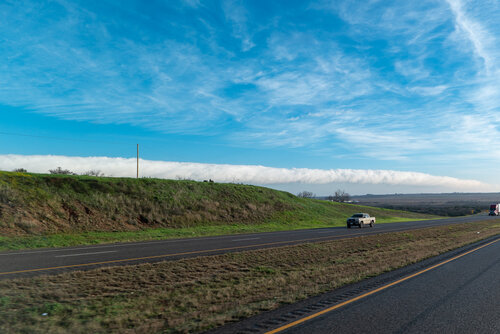
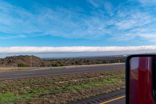
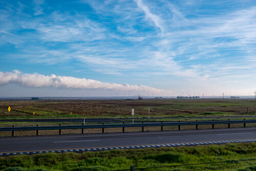
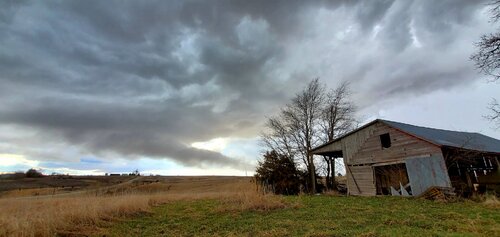
This VERY LONG continuous formation was observed in the morning hours of 2020-03-19, first seen near the Stanton, TX and continuing on the north side of I-20 to and beyond Colorado City, TX area, leading toward a residual ongoing minor rain complex near the Red River [from the previous evening's storms in W/Central Texas]

20200319-SAM_1938.jpg

20200319-SAM_1939.jpg

20200319-SAM_1944.jpg
 
Looks like I haven't missed much after deciding to sit today out. The cell approaching Knoxville, IA probably looks pretty cool, but it's not even tornado-warned as darkness rapidly approaches. Not worth the five-hour drive on the heels of a 3AM-noon work shift what with everything else going on.

EDIT: Looks like what I previously thought might happen in Iowa is happening in Arkansas, with three small supercells all tornado warned. The northern one (near the MO border, too low-topped and far from LZK or SGF to really get a good bead on) is now "confirmed" with a public report.
 
Last edited:
Those discrete supercells originally shown by the HRRR in southern Illinois/Indiana this afternoon were a bust and that severe QLCS just raced across that region. Also was more of a hail event in Nebraska/Iowa.

Essentially, if you weren’t in an enhanced risk today, you didn’t get severe weather (except some hail in southern Nebraska and far southern Texas). Considering that the CAMs were originally showing little/no convection in the slight risk between the 2 enhanced areas this morning, a marginal risk or even a general thunder would’ve been much more apropriate. But, I think the kinematics were just too good-looking today to narrow down.
 
This one was yet another example of when the atmosphere is all cluttered from a number of messy early day storm systems in the target area that result in a lack of significant widespread convection. Isn't this around the 4th enhanced to flop thus far in 2020, be it because of rain-cooled air, lack of shear, or other?
 
Back
Top