• A friendly and periodic reminder of the rules we use for fostering high SNR and quality conversation and interaction at Stormtrack: Forum rules

    P.S. - Nothing specific happened to prompt this message! No one is in trouble, there are no flame wars in effect, nor any inappropriate conversation ongoing. This is being posted sitewide as a casual refresher.

2019-05-26 REPORTS: NM/TX/CO/OK/KS

John Farley

Supporter
Joined
Apr 1, 2004
Messages
1,782
Location
Pagosa Springs, CO
I caught a nicely backlit New Mexico tornado southwest of Clayton this afternoon. A little farther away than I would prefer, in part because I was repositioning and heading east to then get north when it decided to develop, but at least the angle relative to the light was good. It was never condensed all the way to the ground, but the condensation was most of the way down at times, and spotters and chasers closer to it than I was confirmed that it was a tornado. The storm had started out as a nice, isolated supercell, but rapid upscale growth occurred and soon there were storms all over, so I was concerned the show was over. Then this happened. I knew something was up when suddenly a few minutes before the tornado formed there was a barrage of CG lightning from the wall cloud. This continued into the early stages of the tornado. After the tornado ended, the storm evolved into an HP supercell, and more tornadoes were reported, but from my angle they were rain-wrapped. Nice HP structure, though, as you can see in the second picture. There were also numerous reports of hail up to 3 inches in diameter with this storm.

I will post a full report with more pictures and some video as time permits.

IMG_7159-cr--e-fb.jpg

IMG_7165-e-fb.jpg
 
Last edited:
Great job choosing the New Mexico tornado @John Farley . I just got back home. Took my 5 year old boys, so I stayed much further back than I normally would (was at the back of the chaser convergence line all day).

I started in Las Animas, CO. While everybody else was chasing the TOR WAR storm near near Lamar, I went south on 109 after what looked like a good cell. One other spotter network dot did the same. Just the two of us out the hundreds out there. Sure enough, it went tornado warned. I thought I would get some exclusive footage, but sadly my view was blocked by rain, and I couldn't move any further south without driving through hail. Having my boys in the car made that a no-go. So I had to abandon it, and move on to the Lamar storm.

I went up 287 and followed along at the back of the line. Passed the TORUS trucks, and then stopped as everybody else was leaving to let my boys out of the car and hopefully see the tornado from a safe distance. Unfortunately the lowering went back up. Just a funnel. My boys were excited to see a well structured wall cloud though. Their first one :)

When we got to the 287/96 intersection, chasers on ham radio were reporting an accident blocking the road going east on 96. So I decided to go to Eads and gas up, then go north to Kit Carson, and then east on 40 to get back in line. This would have put me right at the front of the pack of cars (everybody else was stuck in very slow convergence eastbound 96 and northbound 385).

As we were going east on 40 though, that storm went from tornado warned to nothing. So I stopped and accessed my options. While sitting there looking at radar, I realized we were in the RFD of the storm to our east, so I let my boys out of the car, and they had fun getting blown over while trying to walk.

Back to the radar... I could still go to the storm to my east - it was still approaching some good shear, or I could go west to a rain wrapped storm that was clearly rotating, but wasn't warned yet. I decided to go west and take my chances on a newer storm. Plus west was the way home, and I had to get home and get the boys in bed at some point anyway. So west on 287 with plans to go west on 94. But about 2 miles before we hit the 94 intersection, the storm we were watching went tornado warned! That was #3 for the day. Third try's the charm?

My new plan was to continue on 287 towards Hugo. We entered the tornado warned area before getting to Hugo, so we stopped and watched. Just me. Nobody else!!! All the spotter network dots were at least 30 minutes away... a long line of them. So I sat there alone with my boys in a clearing in the rain, and watched a small, but clear rotation approach us and then pass by without lowering. It was a small funnel trying so hard, but just couldn't do it. As soon as the funnel passed by us, we were immediately hit with heavy rain, and couldn't see anything. We repositioned a little further east on 287 just outside the rain, and watched the storm with a clear view. We continued watching it for about 20 minutes, but alas, another bust.

At that point we called it a day, and drove home. Although we managed to chase 3 different tornado warned storms, it was a bust. We may not have seen any tornadoes, but my boys did see their first wall cloud, and we also saw two funnels. Very exciting for two little 5 year old boys! And not to mention one happy daddy.
 
Fourth day of chase vacation and another weird one. Started the day in GCK with plans to head first to Lamar for lunch at one of our longtime favorite places, Thai Spicy Basil (as an aside, turns out they changed ownership three years ago, it’s still good, but not as good, and not as authentic), intending to update our forecast there and see how far the warm front was progressing, figuring our ultimate target would be somewhere around Eads or Kit Carson or slightly west, possibly all the way up to I-70.

When we finished lunch it was only a little after 12MDT and we were surprised to see that convection was already initiating down around Springfield IIRC, and an SPC MSD had been issued an hour ago. It was like Campo all over again, jerking around at Thai Spicy Basil and being too nonchalant and non-vigilant about early initiation. The MSD said:

“...midlevel capping will require additional heating and the early convection is not expected to pose a threat in the short term. By around 19-20z, convective initiation is expected in the vicinity of the triple point and southward along the dryline.”

If they had stopped at the first sentence, I might have thought, OK, maybe no threat right now, maybe they are elevated, but once they become surface-based it’s game-on. But the addition of that second sentence made it sound like, “forget this early stuff, the real initiation is still an hour or two away.” We began to head north to our original target but now stuff was going up there too, and the whole area is clouded over with anvil blow-off; no way anything new is going up anytime soon. Then the tornado watch comes out and it talks about convection increasing in coverage and intensity. Oh, so now I guess the early initiation was the start of the main show?!? Seemed to contradict the MSD... But it all looked like crap and I thought, here we go again with the early storms and upscale growth, we are done...

We retreated to Lamar just to wait out the early stuff, there was really nothing to chase and we thought maybe we would have a later afternoon play further north in CO once the early storms moved east and moisture wrapped in on its northeast trajectory N/NE of the triple point. For about an hour I killed time texting friends, reading and posting on ST, not even looking at radar. Then at 3pm we check and see a tornado warning on a cell west of Lamar, and an earlier tornado report (on a different cell I think) right near Lamar!!! I was ready to resign my ST membership right then and there, what the hell is wrong with us, not bothering to monitor radar?!? It’s like we had already mentally bailed on the day, at least until potential later development up N/NW. Based on a quick look at a radar loop, it looked like the Lamar TOR report came from a cell that flew up north from the panhandles and quickly flared up, so I’d like to think it was just a landspout. I’ll have to study that later, unless anybody has some intel on what actually happened.

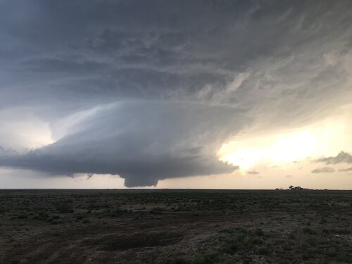
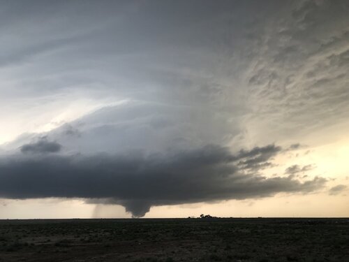
Anyway, the chase was on to the TOR-warned cell west of Lamar. We intercepted it and then went north from Wiley to Eads. There was a constant line of chasers. It was grungy underneath the base but at one point a feature came into view in the shape of a rope tornado but broken into segments. I have seen a tornado rope out and break into segments, but these segments looked like cotton puffs, they were not cylindrical. But they were not in a pattern or direction that could have been scud. The time was around 6:13MDT, and sure enough a report of a tornado on the ground for a minute came out around that time, so maybe we were seeing the last stages of a segmented rope that finally became visible out of the grunge as we got a little closer to the storm? Who knows, just an interesting feature and I would like to know what it was or if anyone else saw it. I am certainly not counting it as a tornado for myself.

At Eads we went east on 96. With limited road options and storm motion, we had ended up on the southwest flank so had to hook slice now on 96 but there was no rotation or TOR warning at this time. When we got back to the SE quadrant we stopped to check out the base, it was pretty mushy but the wrapping rain curtains were pretty cool.

We saw two accidents on 96 between Eads and Sheridan Lake - one SUV nose down in a ditch, and farther up the road a silver Kia had been smashed in the back and an ambulance was on the scene. This is bad stuff. Chaser convergence is now yet another variable to worry about. Now you have to strategize about when to stop so you don’t end up at the end of the line. Nuts.

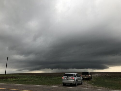
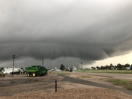
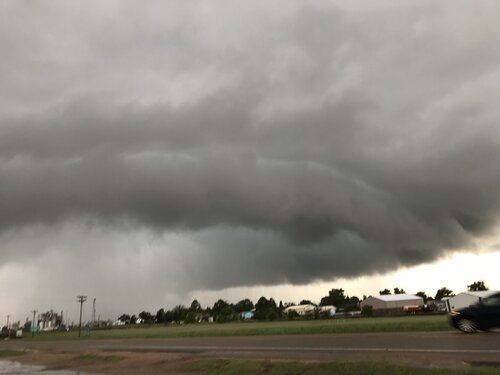
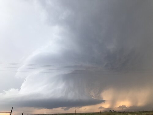
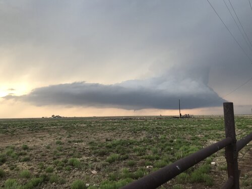
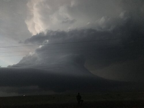
We went north from Sheridan Lake to Cheyenne Wells (CW). By the time we got to CW the storm was an outflow dominant HP; these are the pictures below, one on the way and two in town. We went north out of CW and soon a new circulation center and ragged rotating wall cloud formed down the road just ahead of us. A new tornado warning was issued but the storm became outflow dominant again and we could never again see any discernible features even though I think another tornado warning was issued later.

Soon everything was congealed into a line. A new tornado warning came out in the line back down in CW, and there was another TOR-warned cell back in Hugo that still looked isolated, but its time had to be limited as it was behind all this other stuff, so we didn’t bother going after it. Amazing to see the solid red practically unbroken line from CO all the way down into the TX panhandle, and the one isolated tail-end Charlie tornadic supercell down near Dora NM. The LBB area again!!! We should never have left there on Friday evening...

We called it a day in Burlington and went out for a great dinner at The Dish Room. We discovered this place last year and I highly recommend it. There were a bunch of chasers there and I serendipitously ended up at the table right next to @David Williams and caddy-corned from Jon and Shawna Davies.
 

Attachments

  • 4825CEFF-3136-4414-8D5E-47344F05D6A1.jpeg
    4825CEFF-3136-4414-8D5E-47344F05D6A1.jpeg
    117.1 KB · Views: 0
  • F111086B-7596-4106-84A2-3B02E0C2AF2B.jpeg
    F111086B-7596-4106-84A2-3B02E0C2AF2B.jpeg
    211.3 KB · Views: 0
  • D0CD291B-7481-4A05-9CE6-D571DCD3EF2B.jpeg
    D0CD291B-7481-4A05-9CE6-D571DCD3EF2B.jpeg
    90 KB · Views: 0
Awoke in Dodge City and targeted Lamar. Made it to Syracuse, KS as the first storms of the day started going - one near Springfield, and another farther north. Waited to see how these would evolve before choosing. Skies over Syracuse were overcast and the southeasterly winds were cold. This was the upstream air that any CO storms would be ingesting, so I felt the day was done. As the Springfield storm faded to nothing, I felt my concerns were correct - so I decided to head east for the more solid convection in the Liberal area that should be encountering the frontal boundary near DDC. I arrived on these at Ensign, west of DDC. The radar was a mess, but I was surprised to see very fast inflow with RFD surges evident. This managed to wrap up several times in rapid circulations with funnels that either were very close to producing, or did actually produce. None lasted more then a couple of minutes. Lightning was intense during this, with many bolts hitting the wind turbines.

may2619a.jpg

After this storm encountered the stable air over DDC, I contemplated heading back west to the zone of clearing that managed to take place ahead of the dryine. However, I also noticed that the 18z runs of the CAMs were developing a potent supercell/tornado environment in Illinois back home. That tipped the scales for me, and I began the trek back east. Staying in Cameron, MO for the night.
 
I usually won't post a report if I don't have any pics or vid, but since nobody has posted about the Wiley tornadoes... I guess I should mention that I live 30 miles E of Wiley, and the sky was wonderful to watch around 11AM, with cu drifting NW'wd at about 800mb and higher up cu going NE.

I sat on my couch until about 1:30, when I decided it was time to go after a storm coming up from S of Holly (just like Saturday), but as I headed E on 50 toward Holly I saw a line of chasers going W. OMG I HATE it when that happens!! So, I pulled over and with another radar check I discovered that the storm headed for Wiley had a lot better VIL to it.

While I was waiting for that storm to get within range another storm blew up in the Wiley area, and it had not one but two wall clouds, and then an elephant-trunk funnel appeared about a mile behind the southernmost WC. I called Pueblo at 2:35 and while I was on the phone the funnel reached 3/4 of the way to the ground. I never knew if it was a tornado for sure until I saw two corresponding reports saying it was. It lifted pretty fast, like after 30 seconds (? time becomes blurry in such a situation) and by the time I got off the phone it was gone and I didn't even get a snapshot.

Then it, or another one, came down shortly after, and once again it was gone before I could get my camera going. That was NOT the storm that "everyone" chased to Eads.

Wow, what a scene on 287 and 96. 25 mph, 35 mph, 15 mph all the way from Wiley to Eads. I am not going to estimate how many chasers there were, but if someone said 2000 I wouldn't argue it. Funny thing was, it seemed to be more than 50% Colorado plates. On 96 the storm went to mush, and my car thermometer said the (inflow) temp was 63°, so I went home.

Then, a little later, at home, I had some stuff coming up for me indicating 1.5" hail, so I drove to Lamar to avoid that from hitting my car. Had dinner at Thai Spicy Basil, because the steak place was closed.
 
Yesterday was the most difficult, successful and ultimately rewarding forecast/nowcast ive ever made while chasing.

We woke up in Dighton, KS. Original target was Syracuse to hedge between W KS and N TX PH. Ended up favoring the panhandle and committed to it at 18z. Problem was N if I-40 was getting rocked and stabilized by elevated junk. So - again at 18z - we committed to roughly Lubbock. This was like a 4.5 hour drive, definitely pushing it. But RAP profiles had us confident it would pay off, given favorable multi-CAM ensemble/deterministic trends and observational/satellite data. About an hour from Amarillo it was evident it would be tough as it was very stable looking. We saw CI imminent as large scale ascent (LSA) - evidenced by increasing coverage and depth of Cu behind the dry line - began to spread towards the dry like. The configuration of the ascent was quite linear and favored rapid upscale growth.
8YTcoiO.jpg

We abandoned the NE New Mexico target because of convective coverage and terrain, even missing a few tornadoes due to it near Clayton. Farther south, deep into the 2% tornado risk and severe watch, we noticed CI attempts ahead of the linear LSA. The first few were not very robust. However the subsequent attempt did it and a sustained updraft was born. Slowly, it matured and eventually began a right deviant motion.

Behind it renewed updraft development occurred but nothing could sustain. Its right deviant motion meant that it would remain discrete, even as LLJ kicked on towards the evening. A classic Great Plains tornadic supercell looked to be developing.

We arrived on scene at roughly 2345 Z I think. A persistent, identifiable cone lowering was evident behind a rain curtain. Could’ve been a tornado, I don’t remember. At some point the storm began to reorganize and a landspout appeared, with swirling dust beneath it. Confirmed tornado warning was issued. Whatever.

As low level flow began to increase, winds backed from SSEly to ESEly, possibly a response to the storm scale pressure falls owing to rotation in the low level mesocyclone. This supercell was extremely organized, with pretty stunning structure to go with it. It was obvious, however, it was encountering a bit of inhibition and RAP profiles suggest the same.

I had thought tornado potential was all but over at this point. Out of nowhere, a ragged, well defined wall cloud showed up behind it. Indeed a new supercell had just blown up in supercell #1’s tracks! Even as this occurred and the first cell was dying, a weak funnel/possible tornado developed.

The rotation on the new cell very rapidly strengthened, perhaps aided by storm 1’s outflow. The mesocyclone rapidly expanded in size and it was obvious this storm meant business.


The wall cloud increased in rotational velocities, some of the fastest I had ever seen. Little ribbons of vorticity began to fill in/touch the ground. A rather large tornado was about to develop, it seemed. And then it happened - a tornado was born.

This all culminated in one of my best iPhone shots I’ve ever had, lol. Unfortunately didn’t have the camera on me. Long story. But anyway, what a day. The many adjustments and the fact we had so much stacked against us - but just enough confidence to say “we can get this done” made this the most enjoyable, satisfying and rewarding chases I’ve ever had. Like 5 chasers were out there with us. This day will be hard to top. z3XDrEM.jpg

The tornado lasted roughly ~35-45 minutes with a nearly 10 minute ropeout. Another 3-4 tornadoes occurred overnight.

Attached are some other pics.
 

Attachments

  • 7112D917-1233-4348-BEF6-78556F50F373.jpeg
    7112D917-1233-4348-BEF6-78556F50F373.jpeg
    77.9 KB · Views: 0
  • 035C3847-56CE-42CC-A5CB-4DB08B266F1D.jpeg
    035C3847-56CE-42CC-A5CB-4DB08B266F1D.jpeg
    184.2 KB · Views: 0
  • 3C8A18FC-BB66-45D1-9AA8-D60782CF248E.jpeg
    3C8A18FC-BB66-45D1-9AA8-D60782CF248E.jpeg
    136.4 KB · Views: 0
  • AF3303A8-05CA-4778-A502-DED7D5AA09F7.jpeg
    AF3303A8-05CA-4778-A502-DED7D5AA09F7.jpeg
    104.6 KB · Views: 0
  • 3C45983B-F79C-4C94-9E3C-0884CEFEC0D2.jpeg
    3C45983B-F79C-4C94-9E3C-0884CEFEC0D2.jpeg
    168.4 KB · Views: 0
Caught two incredible storms near Dora, NM. Probably the best structure I've seen, and the full life cycle of an awesome tornado. A great structure show with lightning after dark too. Top three day on the Plains in 10 years of chasing, with all things considered. Stayed the night in Amarillo. Decided at lunch to hang out around Clovis, but with so many storms initiating I dropped south.

The first storm to really start cranking SW of Pep spun up a landspout looking tornado. I could not get pulled over and get a picture of it. The storm then went structure crazy. At one point a super sharp funnel reached towards the ground for a few min but I never saw ground circulation. With the second storm organizing behind this one all the while, I let the first storm go. First storm....
2019-05-27 09.36.31.jpg

2019-05-27 09.31.58.jpg

East of Dora the trailing storm developed it's own incredible mesocyclone structure and then large rotating wall cloud with vortices carouseling beneath it. Started transitioning to a huge cone tornado with clear slot, then it eventually began lifting North and roped out. Pics are from my phone. I took so many 10mm pics of the structure to go over when I get home... and to have the Dora storm tornado too!.. what a day.
2019-05-27 09.28.32.jpg

2019-05-27 09.34.18.jpg

2019-05-27 09.21.54.jpg

2019-05-27 09.11.20.jpg
 
@JamesCaruso I saw that tornado/feature you were talking about. I was on the highway south of Eads I believe and we were looking north and saw the white "cloud" off in the distance. Initially I just thought it was some scud or even just a small updraft into the base of the back end of the tornado warned storm where the broad area of rotation was. We were driving north and as the feature came into better view you could see how it arced to the left heading towards the ground. We were now close enough to get a pretty decent view and again thinking this was some kind of scud/not a possible tornado I was surprised to see how this feature looked like it was on the ground, but the last part of it was in in broken segments that looked white and puffy. It disappeared/completely broke apart shortly after that. I might have caught this on our GoPro dashcam that we normally have running. I'll have to check it.

To finish my report, my chase partner and I left Omaha at 8am with an initial target of Cheyenne Wells, CO. We arrived about 130p and a rather unorganized cell was going up just back to our east in western Kansas. It looked like an unorganized group of multicells so we didn't have a lot of interest in following that back east right away. It eventually did become tornado warned and dropped a tornado near Colby, KS I believe. To our south/southwest were the first storms that had already gone up south of Lamar. Again those storms didn't interest us at first so we held tight for a while in Cheyenne Wells to see if anything became better organized. Meanwhile the cooler temps, clouds, and storms going up early felt like this was already going to be another moderate day risk bust. Finally a couple of more isolated cells formed again south of Lamar so we made a break for those.
We went south to Sheridan Lake, then west towards Eads running into a cell that was briefly tornado warned and dumped a lot of marble sized hail on the road that even accumulated enough to make it a bit slick.
We turned south on Hwy 287 and as the main storm of the day in this area came into view, we could see a huge beefy wall cloud. Of course by the time we made it to Wiley, the wall cloud had mostly fallen apart and the hoard of chasers were all starting to bail back north. We pretty much turned right back around and followed the storm back north as it was west of 287. It wrapped back up again becoming tornado warned and after stopping a couple of times to watch the storm it crossed the highway moving northeast.
We made it back to Hwy 96 going back east towards Sheridan Lake. It was along this part of the chase that was perhaps the coolest as first there was a "low-bow" that formed with the backlit sun behind us shining on the storm. You could see rapidly moving rain curtains and again the sun shining allowed you to see the massive rain drops falling from way above as they hurtled towards our car as we drove through the rain. The main area of rotation of the storm was just north of Hwy 96 at this point so there was very strong inflow into a pretty, bright white lowering/wall cloud that was lit up by the sun as well.
Thereafter we saw the chaser vehicle who had gone into the ditch and a short while later traffic had to stop for the rear end accident and the ambulance that was called.
We stayed with the storm as it headed back to Cheyenne Wells where it looked rather outflowish. The storm ended up getting another tornado warning with it north of town but we didn't see anything with it at that point. Once we got back to I-70 we called the chase and began the long drive back home getting home at 230am.
All told this was my longest one day chase ever in 12 years. Ended up driving almost 1100 miles spending 18 hrs and 45 minutes in the car all for a rather disappointing final result, especially seeing the moderate risk/15% hatched risk. I didn't even end up with any pictures!
 
I chose the northeast Colorado target, or more like the target chose me. Despite leaving home at 6AM, storms were already firing in southeast Colorado by the time I made it into the state, so that was out of play. I hung out in Greeley and headed for Wiggins once the first cell went up. It was amazing how fast it went from a blip to hailing on top of me. Luckily I made it through to the other side before it got too big. From there I was able to head SW to a tornado warned supercell near Roggen.

A low wall cloud was visible with a funnel behind it in the distance. After examining my time lapse footage I believe it did touch down briefly.


Funnel and Wall Cloud
by Kevin Palmer, on Flickr


That turned into a cool green rain core before another wall cloud formed near Wiggins.


Drenching
by Kevin Palmer, on Flickr


Train Under Wall Cloud
by Kevin Palmer, on Flickr

I followed it north to Raymer where it showed some gorgeous structure. More wall clouds and funnels, and a spiraling updraft were fun to watch.


Raymer Supercell
by Kevin Palmer, on Flickr

A little further east I was hit with very strong winds which made it hard to even open my car door. The storm weakened after that so I let it go. There were hardly any other chasers around, especially compared to the next day.


Cows and Stoneham Storm
by Kevin Palmer, on Flickr
 
Here are a couple more pictures from my chase southwest of Clayton, NM. These are video captures and are more zoomed than the previous pictures I posted of this tornado.

chase52619-5.jpg

chase52619-6.jpg


You can see my full report, including video of nearly the entire lifecycle of the tornado, at:

http://www.johnefarley.com/chase52619.htm
 
This was the Lamar storm. I know many others saw this as well, and I know most if not all of this is rain. I´m just wondering if anyone that had a better vantage point if this actually produced a tornado, because it sure does look like one. I was actually driving at the time, so I only caught glimpses of it in real time. Sorry for the poor quality, because I was driving like I said.
18579Screenshot_20190601-130015.pngScreenshot_20190601-130040.pngScreenshot_20190601-130817.pngScreenshot_20190601-131032.pngScreenshot_20190601-131106.png
 
We've all had a lot of COVID-19 talk with little weather to spice things up lately. The least I can do is give you 4 minutes of quarantine relief. Here's my timelapses of this nice, but crowded, chase from last year. The Eads to Cheyenne Wells supercell was pretty pleasant if you could avoid the conga lines.

 
Back
Top