2019-05-21 EVENT: KS/MO/IL/IA/AR

Jesse Risley

Staff member
Joined
Apr 12, 2006
Messages
2,260
Location
Macomb, IL
Though it's still a ways out, TUE bears watching as the main piece of energy works atop the subtropical ridge and ejects into the Central Lowlands, with timing being very crucial here. The mid-level low will gyrate into the northern Plains as a potent 100+ kt H5 jet core traverses into the mid-MO valley. The main surface cyclone is poised to deepen and lie somewhere in SC NE, as a warm front positions itself latitudinally between the MO River and I-80, though position of surface features is likely to change over the next 96 hours. Surface boundary should shunt the best moisture east of I-35 by midday, with a triple point somewhere between OAX and STJ. Vort signals and GFS convective precip progs are indicating ongoing precip in the western portion of the warm sector early in the day, and this has been consistent. However, rather ominous instability and shear values persist further east into central MO and SW and central IL, commensurate with the surface warm front and signals of burgeoning instability well east of the earlier convection across the central MO river valley. This appears co-located within a zone of favorable mid and low-level lapse rates, so all modes of SVR are possible, though many details remain to be seen as the synoptic scale event continues to evolve into late weekend.
 
Kyle, just so you know, the area just SW of St. Louis is a very difficult area to chase - very hilly, lots of trees, limited and winding road network, and then you can get stuck at the Mississippi River with no way to cross. Or get stuck in metro area traffic even if the storm is moving toward a place where you can cross, most of which are in the metro area. I think a better strategy would be to position yourself near the warm front just on the Illinois side of the river, and let the storms come to you. Of course that depends on a lot of details of how things set up, but warm fronts in Illinois can often give you nice supercells and tornadoes, especially if you can get one that moves right along the front.
 
John is right. I live in Indiana, chase the region regularly, and I won't cross into the St Louis metro unless it's absolutely needed; too many variables to ruin a chase quickly when the Illinois side is wide open by comparison.

And as John mentioned, the roads on the Missouri side differ greatly in terms of visibility and tree coverage.

Be aware though, there's a significant cellular dead zone for multiple carriers north of St Louis on the Illinois side along both sides of I-72 between the river and about Jacksonville, IL. I use Verizon (and a booster) and get virtually nothing. In addition, the radar coverage northwest of StL can be sketchy, but that might be away from where you're going.
 
Even east of St. Louis into Illinois can have spotty visibility. There are plenty of open spaces, but it seems every few miles there will be a very large creek or river valley that is heavily wooded which can lead to frustration. I will third staying out of Missouri if possible and definitely out of the St. Louis metro.
 
What Adam said, too. It won't truly open up until you get closer to Effingham, but if ya gotta choose a side of the river, IL is the better area for chasing.
 
Staff note
Please remember to keep in mind the posting standards for Target Area threads. Some of the posts in this thread are borderline inappropriate regarding content (or lack thereof). Meteorological discussion is to be prioritized. Chasing logistics are acceptable provided they are relevant to the event and are about more than personal commentary (e.g., "I would stay away from route XXX because it's not good for chasing". In this case, delve deeper into explaining why.) and we would prefer logistics conversations pertain to the meteorological aspect whenever possible.
 
I’m thinking I might chase south central/southeast Nebraska on Tuesday just east of the strong surface low that’s forecast to be southeast of North Platte late afternoon. There’s a warm front draped to the east of there as well where southerly winds back to the east. The 3k NAM shows storms well out in advance of the surface low in Missouri where the current higher risk by the SPC is at, but it develops cells near the surface low which should move north and interact with the warm front. Shear of 40+ knots, 0-1 km helicity 150+ and high amounts of low level CAPE (some soundings were showing over 200 j/kg) should help with stretching in this almost cold core setup. Hoping to get lucky and catch a tornado since I’ll be sitting out tomorrow.
 
John is right. I live in Indiana, chase the region regularly, and I won't cross into the St Louis metro unless it's absolutely needed; too many variables to ruin a chase quickly when the Illinois side is wide open by comparison.

And as John mentioned, the roads on the Missouri side differ greatly in terms of visibility and tree coverage.

Be aware though, there's a significant cellular dead zone for multiple carriers north of St Louis on the Illinois side along both sides of I-72 between the river and about Jacksonville, IL. I use Verizon (and a booster) and get virtually nothing. In addition, the radar coverage northwest of StL can be sketchy, but that might be away from where you're going.
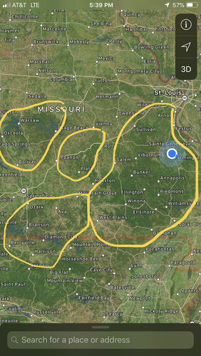
40D2B319-71BB-40D4-8788-194F50AED510.jpeg

Image shows most areas that are easily obscured by hills and trees. Some areas within these circled points also provide long range viewing areas as well.
 
In my opinion, tomorrow 5/21 looks like a down day.

Kansas/adjacent Nebraska could initiate a few storms, but wind profiles are pretty ugly looking with backing winds aloft. There could be some left-moving, transiently supercellular storms wrapping around the cutoff low. It's not worth a long drive to me, but maybe that's because I've been all over the Southern Plains the past three days with virtually nothing to show for it.

Into the Ozarks/Mississippi Valley region, it looks like a squall line with embedded QLCS tornadoes possible. Not worth chasing, in my view, especially in the given terrain. If it's a local chase, maybe, but again, not worth an overly long drive to me.
 
There are several potential targets materializing today, though it does not look like a substantial supercell tornado day by any means. NE/E Kansas is worth keeping an eye on as the upper-level low gyrates east into W KS, with cold H5 temps overspreading the region from the west as the airmass potentially recovers just in time for a cold-core(esque) setup. A narrow tongue of steep lapse rates may coalesce with ambient 0-3km MLCAPE and vorticity in the region as quasi-discrete storms form across the region by late afternoon. There's enough shear to produce rotating, low topped convection that could yield a few tornado reports today. Across the Ozark Plateau northward into the mid-Mississippi River valley / Central Lowlands region, shear vectors and CAMs are pointing towards the evolution of a largely linear complex that pushes towards the MS River by early evening. There doesn't look to be much bona fide clearing ahead of the line, although shear profiles, 0-3 km MLCAPE values and substantial streamwise vorticity values being progged in the lowest 1 and 3 km regions support an enhanced QLCS tornado threat in this region today.
 
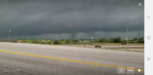
Picture taken off of my livestream on 5/21 near hwy 40 between Weldon Springs and Chesterfield
 

Attachments

  • Screenshot_20190522-165946_Periscope.jpg
    Screenshot_20190522-165946_Periscope.jpg
    100 KB · Views: 0
Back
Top