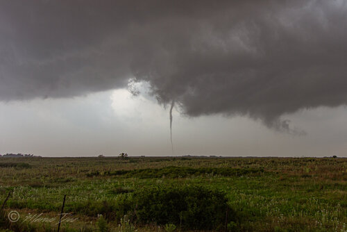
Good day all, Here is my report for storms for May 20, 2019...
Chase Summary: May 20 was an anticipated major chase day, with ultimately a moderate, then a rare high risk outlook, being issued for the target areas by the SPC. Although many storm chasers including myself caught tornadoes, the day (fortunate to threats to life and property) did not realized the feared violent tornado outbreak it could have been. Upon forecasting and preparing the vehicle, I left Amarillo via I-40 and 287 east and southeast, targeting an area from Childress, Texas northward, with the main primary target of Hollis, Oklahoma. The SPC had a high risk in place for much of the SE TX Panhandle and SW Oklahoma as of 1630z, with a staggering 45% tornado, 45% wind, and 45% hail probability (all hatched for significant). Several Mesoscale Discussions were issued, including 698 and 699, and subsequent PDS (particularly dangerous situation) tornado watch boxes 197 and 199, both valid until 10 PM CDT. I arrived in Hollis, OK via Highway 62 out of Memphis, TX and waited there wish some other chasers. A few hours later convective initiation was underway in Texas, with two supercells. I headed back west to Highway 83 south, intercepting one of the supercells near Paducah, TX and witnessed the entire life cycle of a thin tornado. Visibility was poor in the storm environment (hazy). Things became very difficult with the fast storm motions (and attempting to cross the Red River), so keeping up with this storm was difficult, requiring either going back north on 83 / 62 well west of the storm through Hollis again, or east on Highway 287 and try to find a viable route north (SR 6out of Quanah was jammed with chaser traffic). There was an attempt to try to go north on FM 680 or 1033, but those either were dead ends or not paved (mud)! Back tracing and lost time making catching the supercell, later to produce another tornado in Magnum, OK, impossible. I headed back west on 287 to 62 / 83 north, encountering another supercell that was outflow dominant, then SR 30 out of Hollis to I-40 near Erick, then east. The setup became more and more of a flooding MCS than a tornado outbreak, with the Paducah and Magnum tornadoes being the best storms of the day. Through torrential rains, I headed east on I-40 to Oklahoma City for the night.
Storm Interception Details Are Below
1). May 20, 3:30 PM - Interception, indirect penetration, and observation of a very severe and tornadic thunderstorm from near Paducah, Texas in Cottle County from along Highways 62 and 83, and near Highway 287 south of the Red River. The storm was a cyclic supercell storm, and a thin tornado was observed just north of Paducah and west of Highway 83. This was the same storm that would merge with a supercell to its immediate west, and later cycle again farther northeast near Magnum, OK (that was not reachable due to poor road options and fast storm motions). Other conditions encountered were 50 MPH winds, frequent lightning with close hits, heavy rains, and hail up to 2" (the main core was indirectly penetrated). Conditions causing the storm were surface heating, dryline / boundary interactions, a low pressure system, and intense upper level wave / jet stream aloft. Documentation was digital stills and HD video. A 2016 Jeep Wrangler was used to chase the storm. A PDS tornado watch watch was also valid for the area until 10 PM CDT.
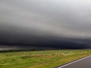
2). May 20, 5:00 PM - Observation and indirect penetration of a severe and thunderstorm near the intersection of Highways 62 and 83 in Childress County, Texas. The storm was an outflow dominant HP supercell storm that evolved to a bow / line segment. This became involved in a line / MCS of strong and severe storms as it moved east and northeast into western Oklahoma from along SR 30 north of Hollis and south of I-40. The core was not penetrated but a spectacular view of a dark, greenish tinted shelf cloud was noted west of Hollis, OK. 40 MPH winds, very heavy rains, small hail, and frequent lightning was also observed. Conditions causing the storm were surface heating, dryline / boundary interactions, a low pressure system, and intense upper level wave / jet stream aloft. Documentation was digital stills. A 2016 Jeep Wrangler was used to chase the storm. A PDS tornado watch watch was also valid for the area until 10 PM CDT.
Pictures For May 20, 2019 Are Below
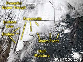 Above:
 Annotated satellite image showing convective evolution and the synoptic setup during the afternoon of May 20, 2019. The linear nature of the dryline orientation (SW to NE instead of N to S) averted stronger tornadoes from forming on this day.
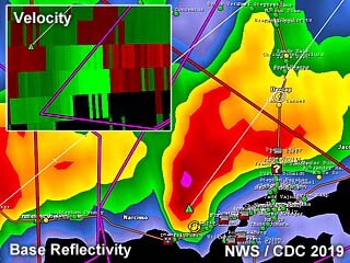 Above:
 Radar image (base reflectivity) of a tornadic supercell developing near Paducah, Texas during the early afternoon of May 20. The inset shows the Doppler velocity of the developing tornado.
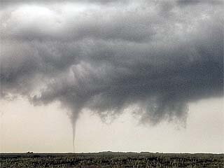 Above:
 Tornado touches down near Paducah, Texas during the early to mid afternoon of May 20. The view is to the WSW.
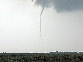 Above:
 Thin rope stage of the Paducah, Texas tornado on May 20. The view is to the W.
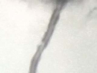 Above:
 Close up view of the tornado near Paducah, Texas on May 20 showing the thin and hollow structure of the vortex tube.
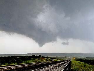 Above:
 Storm cycling and producing another large funnel, or even a brief tornado, west of Childress, Texas on May 20. The view is to the SSE. This same storm will eventually produce another series of tornadoes, including the one near Mangum, Oklahoma.
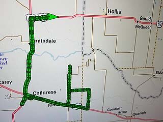 Above:
 View of the navigation software and tracking showing how difficult it was to find a way back across the Red River. The original supercell can be considered "lost" at this point!
 Above:
 The storms near Hollis, Oklahoma later in the day became an active squall line and messy MCS (instead of the feared cluster of violent tornadic supercells). This shelf cloud and strong outflow denotes the chase day of May 20 is pretty much over.
Note: For DETAILS on this storm / setup as well as others in May 2019 … Please visit the link BELOW for more information!


