2019-04-30 EVENT: OK/KS/AR/MO/IL/IN

Marc Gebhard

Enthusiast
Joined
Feb 15, 2015
Messages
8
Location
Dallas, TX
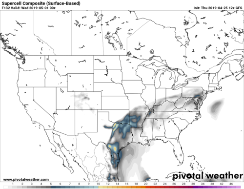
Is it too early to start talking about next Tuesday (April 30)? SPC already has a severe risk over most of OK and northern TX. Here's the 0 Z GFS Supercell Composite from the 12 Z (Thurs, April 25) run. It is worth keeping an eye on as we approach next week.

17836

pivotalweather - Models: GFS
 
Last edited:
As a staff member who watches TA threads carefully, your post is borderline regarding whether it contains acceptable material for a TA thread. Can you elaborate on the nature of the threat in addition to just posting an image that anyone can easily access?
 
Hi Jeff. Point taken. I won't claim to be an expert at all. I was basically just hoping to get the thread off the ground. Looking a bit deeper, it does appear that SBCAPE (over 3000 in parts of the risk area) and 500 mb shear (35 near DFW and up in the 50 range up near OKC) look to be in place...at least according to the latest GFS, pointing to a significant event...but I realize we are several days out and we will have to wait to see where things go. I'm looking forward to hearing what more experienced forecasters and chasers have to add to the conversation.
 
Waning 850s that are out of the west are the biggest thing keeping my excitement level down for Tuesday. Of course they try to improve a little bit as the LLJ ramps up, but looks like way too little way too late. GFS and EURO are also widely different with dryline orientation and if the EURO wins out, itll be a sloppy SW-NE orientation which never works out. A severe weather day for sure, but right now I am not too excited for good supercell or tornado potential.
 
GFS at the dryline bulge: Veered 850mb flow, barely-southerly surface winds, only moderately-favorable lapse rates, the main upper jet streak departing the area early in the day and widespread convection breaking out in the morning from said early energy. Euro: huge moisture-scouring thunderstorm complex roaring through the area in the morning, shunting the moisture southeast to Dallas with little time for afternoon recovery. Maybe a needle-in-the haystack play if a ribbon of recovery moisture can sneak in behind the early-day stuff, but not likely.

Not very optimistic for a trip for this one as it's shown now. Especially since a warm front play might exist in the Midwest.
 
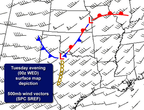
The threat remains, but I'd agree with a generic SLGT delineation right now. My feeling is that we won't have much clarity until Monday evening, at the earliest, as convective overturning on Tuesday could be a major issue. Still, just looking at the bigger picture, there is not a classic supercell look in the model depictions, given deep shear vectors nearly parallel to a surface boundary draped from southeastern Kansas into central Oklahoma.
SREF.png

Assuming that a massive MCS does not evolve, low-level hodographs may be quite favorable for tornadoes. This is assuming that surface winds remain backed and there is not too much veering of the low-level jet.

Bottom line, I'm not overly impressed at this point, but at least some severe thunderstorms will be probable from the southern Plains into portions of Kansas/Missouri. Will there be discrete, tornadic storms in the warm sector or farther southwest along the front, or more of a large MCS scenario? Stay tuned.
 
Tuesday looks better than the debacle progged last week; but, I agree with Quincy it's not great. Local chasers and/or people already out there have a shot in two possible areas IMO. Pls reference Quincy's surface chart fcst above...

Missouri has a slim chance of living up to its Show-Me State motto on the warm front. LLJ is forecast to make it up there. However upper winds will not be as robust as farther southwest. Huge MCS rolling down I-70 is other other risk.

I would probably target farther south. Look for (hope for) an outflow boundary south of the synoptic cold front. If not some progs have the air immediately behind the CF not too cold. Perhaps look for its intersection with the DL. That is the triple point in Qincy's chart.

Always good to have a conceptual model going before looking at numerical models. Some VBV is forecast way up high. Should not be a deal breaker. Surface features are key Tuesday IMO.
 
12z data is rolling in. 3km NAM has been trending more toward linear MCS development over much of the threat area. 12z HRRR is just into range now, so won't focus too heavily on specifics at 30-36 hours, but I will say that it is more aggressive with destabilization across most of Oklahoma and even into the eastern Texas panhandle.

It times like this, it's helpful to look at SREF/HREF and a blend of models. They highlight a fairly broad area under the threat, similar to the overnight Day 2 convective outlook. As @Jeff House mentioned, look for any boundaries left over by convection tomorrow morning. Assuming the front remains largely SW-NE oriented, any boundaries will help offset some of the wind profile concerns.

The triple point is always a possibility. If it's too far south, as some data suggests, weak forcing and relatively modest low-level wind fields may be tough challenges to overcome. Recent data also highlights the potential for modest to moderate destablization behind the cold front, from the eastern Texas panhandle into northwestern Oklahoma.. As we get later into the season, especially in the southern Plains, air-mass recovery behind a cold front becomes easier to achieve.

It's a sit and wait deal. Not a setup I'd advise making a long trip for, especially with convective evolution still being a major wildcard.
 
The GFS is much more gung-ho with the western area destabilizing by 00Z, but at this time range, I will hang my hat more on the higher-res models. This early in the season it is hard to overcome the AM storms that are sure to occur, plus there is no really good upper or low-level forcing to get redevelopment of storms back to the west. The eastern area is way too messy convective mode wise, plus the chase territory is not the best. So I am sitting this one out.
 
I went ahead and added IL and IN to the titular portion of the thread, particularly after looking over the 12z/29 runs of the NAM and NAM 3k, along with earlier runs of the GFS and similar trends noted on the 00z/29 ECMWF with what severe weather parameters I was able to view.

Climatologically speaking, with a sharp warm front vacillating somewhere east of the surface low, given the forecast instability, low-level vorticity and ambient mid and low-level lapse rates, there is a conditional threat for supercell tornadoes in the warm sector with any storm that interacts with the frontal boundary and takes advantage of streamwise vorticity in place. This would extend into W IN too, before the main MCS, with an attendant threat for damaging winds, crosses the Mississippi River late evening. This threat appears concentrated in a narrow corridor between I-72 and I-70/I-64, or wherever the front sets up and points south, coincident with the best deep layer shear parameters and whatever instability actually materializes.

CAMs aren't necessarily indicating a plethora of robust convection across IL into IN, but they are indicating some convection will fire INVO a rather notable mid-level perturbation overspreading the region where the warm front will lie draped as the atmosphere destabilizes throughout the morning tomorrow. There's also the threat of lingering convection from TSRA tonight across the region, and as is par for the course, how much and to what extent the warm sector south of the main WF can destabilize tomorrow, especially given the overrunning stream of mid-level perturbations that could continue to initiate broader scale forcing for ascent and keep convective overturning an ongoing caveat.
 
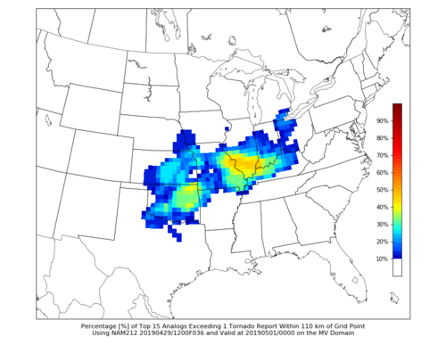
Analog data highlights two areas with a relative maximum of tornado potential, with one being over eastern Oklahoma and another near the warm front from Missouri into Illinois. Exact placement of the warm front will certainly vary based on model progs and analog graphics such as these give a rough idea of where past, similar setups have performed.

Multiple analogs from the top 15 averaged below and others show a stationary front draped across Oklahoma with a warm front lifting north through MO/IL, similar to what is expected tomorrow. Not all of these events produced, but several of them did.
PRTORNC01_nam212F036.png
 
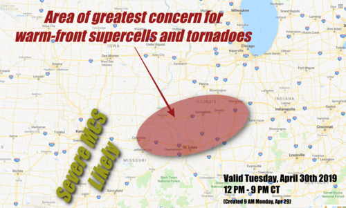
Currently eyeing the corridor between St. Louis and Springfield for warm front tornado potential. Given that the warm front will be gradually moving north throughout the afternoon and evening and storm motion doesn't look too fast, there should be enough time spent along the front for a potential storm to produce before it eventually crosses into the stable air ahead of the front. This of course assumes anything goes up out in the warm sector ahead of the MCS in Missouri being progged by CAMs. Obs late tomorrow morning will determine if I bite or not.
 
Growing more and more concerned about a few supercells/tornadoes in the vicinity of the warm front across parts of eastern Missouri into west/central Illinois on Tuesday afternoon and evening. Potential pitfalls do exist.

There are a lot of convective implications between tonight and tomorrow morning - with one or more MCS potentially moving through/near the target area.

That being said there has been a consistent signal going back to late last week that we will see broad unstable warm sector on Tuesday afternoon featuring 0-3 km CAPE > 200 j/kg thanks in part to surface dew points in the upper 60s to near 70F underneath a broad 50 knot LLJ.
Give me those things alone along/south of an Illinois warm front in late-April and I am there every time. Additionally, high-resolution ensembles have continued to initiate surface based storms ahead of a subtle wave near St. Louis by mid-afternoon Tuesday.

Assuming there is no drastic shift in the forecast parameters, these storms should waste no time taking on supercellular characteristics and could produce a few tornadoes. Given deep moisture, ample low-level CAPE and low LCLs, a sizeable tornado would not surprise me.

What could go wrong? A lot of the potential ruiners don't seem to be present. Too much cold air north of the front? Too much WAA convection suppressing warm front movement? For now (and back to late last week) this does not seem to be an issue tomorrow.

Instead, the warm front is forecast to slowly lift through the day with the subtle surface wave, allowing storms the ideal longevity within that highly sheared environment, rather than being undercut or crossing the WF too quickly.

There is still plenty of time to go on this one with again, many convective implications in play before we get to Tuesday afternoon. The consistency and tendency for conditions to actually *improve* with each run, coupled with high-res ensemble support have me concerned.
17854
 
Last edited:
I am eying Eastern MO/Western IL tomorrow as well. I like that the low level jet becomes very focused in this region by late afternoon near the warm frontal boundary with it lifting northward. CAPE/low level shear are very robust along this boundary with significant tornado parameters pegging quite high. The long range 12z HRRR hints at a very isolated convective cells firing ahead of the main MCS and a fairly robust shortwave pushing through the area should be enough to initiate convection (as mentioned before). My concerns for tomorrow is that it could end up similar to 4/29/17 in that a severe MCS pushes across the target area with damaging winds and embedded tornadoes (IE messy storm modes). Otherwise, I'm becoming concerned that a corridor from Eastern MO into West Central IL could see some tornadic activity tomorrow afternoon/evening despite storm mode concerns. Jerseyville, IL would be my starting target I think, maybe cross into Missouri if need be....but I'd rather stay on the IL side of the river where the terrain is better if I can.
 
I would focus on the are over southeast KS-southwest MO and eastern OK. This region is closer to the ejecting mid level impulse and 250mb speed max where there is decent CAPE. Initial storm development should include some supercells before becoming more linear before sunset. The region over eastern MO into IL might occur after dark?
 
Back
Top