Quincy Vagell
EF4
It's hard to ignore an intense surface low tracking across Kansas in April (sub-984mb and possibly as low as 980mb), however this setup will likely fall short of any significant, widespread severe weather event for a variety of reasons.
Place a 984mb low over central Kansas during peak heating in April with strong surface heating in the warm sector supporting 1,500 to 2,500+J/kg CAPE up and down, immediately ahead of a dryline, along with strong, veering with height, wind profiles. It sounds good, but boundary layer moisture is lacking. Sure, dew-points may possibly reach 60F in parts of Kansas, but with very warm boundary layer temperatures (80s F near the dryline and near 80 in the warm sector), there is going to be a substantial temperature to dew-point spread. Past tornado outbreaks in the central Plains in early to mid-April tend to feature higher dew-points and somewhat lower actual temperatures. Case in point 4/14/12, which saw dew-points in the mid-60s, at least a solid 5F warmer than what is expected tomorrow.
What does this lack of moisture mean? Look at forecast soundings up and down the dryline/warm sector from central Kansas to the Oklahoma border. You will find convective temperatures near 90F and relatively dry profiles up to at least 700mb. Maximum temperatures are unlikely to get much higher than the lower 80s here. The vast majority of models show no convective initiation southeast of the surface low and with good reason. The only model that shows sustained convection taking place here is the 12z NSSL WRF, which doesn't seem to be supported by the data. It has similar thermodynamic profiles to most other models, so it's not like it's drastically overdoing temperatures and/or dew-points.
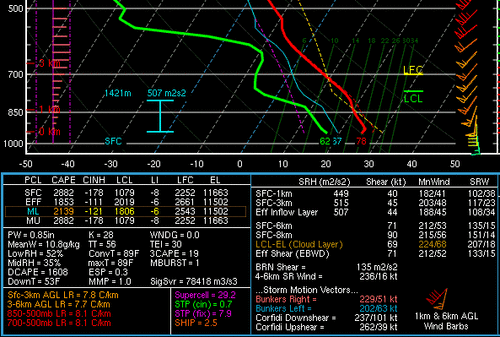
Example of a 12z 3km NAM forecast sounding at 00z Thursday in south-central Kansas:

How about farther north near the triple point? This is where convective initiation is more probable, due to a combination of better convergence and frontal forcing, as well as moisture quality in the 850-700mb layer. Here, it is likely that convection will develop by mid to late afternoon, but also note the sharp temperature gradient on either side of a warm front that should be draped from north-central Kansas to southeastern Nebraska. Should convection ride the warm front, then there could be a long-lived supercell or two into the early evening.
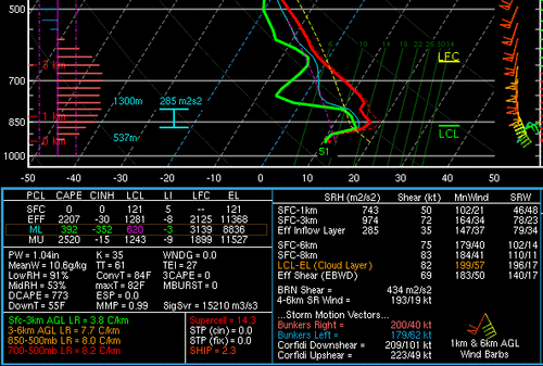
Near and just north of the front, convection seems likely, but this convection will likely form in, or at least quickly move into, a much more stable near-surface layer. Forecast soundings near the central KS/NE border around 00z Thursday show about 2000 J/kg MUCAPE, but little to no SBCAPE, as surface temperatures will probably be in the 40s/50s. This convection could very well produce large, if not locally significant hail, given elevated instability, steep mid-level lapse rates and large to very large hodographs.
Example of a 12z 3km NAM forecast sounding in far south-central Nebraska at 00z Thursday:

If one is looking at UH tracks, of course it's reasonable to see a few intense tracks being progged from north-central Kansas into southern Nebraska, but note that most of these tracks are forecast north of the warm front and are associated with hail as the predominant threat.
To summarize:
Will there be any tornadoes? It's possible near the triple point, but even there, questions arise with storm movement and if the storms will track near/just southeast of the warm front, or move north into a more stable near-surface layer.
The main limiting factor here is better moisture, especially in the boundary layer. If dew-points were at least 5F warmer, we might be talking about a supercell tornado outbreak, but that is not going to happen, at least not south along/ahead of the dryline.
I am not including Iowa in the threat title, since any severe threat in western portions of the state will be well after dark and associated with elevated convection.
This event is a good example of why looking at severe weather indices alone is usually not a good idea, as a very favorable CAPE/shear overlap does not automatically promise supercell storm development:
Place a 984mb low over central Kansas during peak heating in April with strong surface heating in the warm sector supporting 1,500 to 2,500+J/kg CAPE up and down, immediately ahead of a dryline, along with strong, veering with height, wind profiles. It sounds good, but boundary layer moisture is lacking. Sure, dew-points may possibly reach 60F in parts of Kansas, but with very warm boundary layer temperatures (80s F near the dryline and near 80 in the warm sector), there is going to be a substantial temperature to dew-point spread. Past tornado outbreaks in the central Plains in early to mid-April tend to feature higher dew-points and somewhat lower actual temperatures. Case in point 4/14/12, which saw dew-points in the mid-60s, at least a solid 5F warmer than what is expected tomorrow.
What does this lack of moisture mean? Look at forecast soundings up and down the dryline/warm sector from central Kansas to the Oklahoma border. You will find convective temperatures near 90F and relatively dry profiles up to at least 700mb. Maximum temperatures are unlikely to get much higher than the lower 80s here. The vast majority of models show no convective initiation southeast of the surface low and with good reason. The only model that shows sustained convection taking place here is the 12z NSSL WRF, which doesn't seem to be supported by the data. It has similar thermodynamic profiles to most other models, so it's not like it's drastically overdoing temperatures and/or dew-points.
Example of a 12z 3km NAM forecast sounding at 00z Thursday in south-central Kansas:

How about farther north near the triple point? This is where convective initiation is more probable, due to a combination of better convergence and frontal forcing, as well as moisture quality in the 850-700mb layer. Here, it is likely that convection will develop by mid to late afternoon, but also note the sharp temperature gradient on either side of a warm front that should be draped from north-central Kansas to southeastern Nebraska. Should convection ride the warm front, then there could be a long-lived supercell or two into the early evening.
Near and just north of the front, convection seems likely, but this convection will likely form in, or at least quickly move into, a much more stable near-surface layer. Forecast soundings near the central KS/NE border around 00z Thursday show about 2000 J/kg MUCAPE, but little to no SBCAPE, as surface temperatures will probably be in the 40s/50s. This convection could very well produce large, if not locally significant hail, given elevated instability, steep mid-level lapse rates and large to very large hodographs.
Example of a 12z 3km NAM forecast sounding in far south-central Nebraska at 00z Thursday:

If one is looking at UH tracks, of course it's reasonable to see a few intense tracks being progged from north-central Kansas into southern Nebraska, but note that most of these tracks are forecast north of the warm front and are associated with hail as the predominant threat.
To summarize:
- A strong surface low is likely, but low to mid-level moisture will be lacking.
- Convection is unlikely down the dryline to the south of the low.
- Elevated convection is likely north of the surface low, but should pose mainly a hail threat.
- There is a narrow window of opportunity for surface-based convection near the triple point.
Will there be any tornadoes? It's possible near the triple point, but even there, questions arise with storm movement and if the storms will track near/just southeast of the warm front, or move north into a more stable near-surface layer.
The main limiting factor here is better moisture, especially in the boundary layer. If dew-points were at least 5F warmer, we might be talking about a supercell tornado outbreak, but that is not going to happen, at least not south along/ahead of the dryline.
I am not including Iowa in the threat title, since any severe threat in western portions of the state will be well after dark and associated with elevated convection.
This event is a good example of why looking at severe weather indices alone is usually not a good idea, as a very favorable CAPE/shear overlap does not automatically promise supercell storm development:
Last edited:
