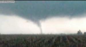
2017-5-26 REPORTS: IL/IN/CO/KS

Joined
Apr 14, 2017
Messages
10
Location
Illinois, United States
What can I say about Friday? Well it was one of those days that a surprise curveball was thrown. The day started out with nothing significant on tap and no severe weather anticipated. We began the day in a marginal with no real good parameters. But as the day progressed that would quickly change drastically. About mid-morning a low pressure system formed over Northern IL allowing for the atmosphere to destabilize. As things progressed throughout the early afternoon, an enhanced level of low level shear became present along a warm front that was draped over a line extending from Bloomington to Champaign IL. (Always watch out for that in Illinois.) The Combination of these two things would trigger the possibility for isolated severe thunderstorms to develop along the boundary. The SPC would soon upgrade portions of north central to eastern IL and northwest Indiana to a slight risk.

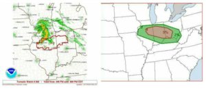
With the presence of the warm front and the low level shear, a slight tornado threat developed and the SPC would issue a 5% for portions of Illinois into Indiana. At around 3 pm, a tornado watch was issued until 8 pm. To be completely honest, I was totally unaware that any of this had transpired. I work 12 hour days and have to be at work at 4 am. It wasn't until I got off work at 4 pm did I even see this upgraded severe weather potential. I literature had 10 minutes to look over models and everything the SPC had put out. I glanced at radar and to my surprise storms had already initiated. A line of thunderstorms had approached the Peoria area an hour or so prior. There was some additional convection to the SW of this line that would become the storm of the day. An isolated thunderstorm which had moved just north of Bloomington near Hudson was quickly taking on supercell characteristics. I literally had to make chase immediately upon leaving work and I am quite lucky all this occurred in my backyard. I made the quick drive north to Colfax IL and sat at Waited.

This supercell had already began to exhibit some rotation and quickly developed a hook on it. I got to the NE side of Colfax and waited for this supercell to get closer. I had a perfect viewing position and it didn't take long for it to reveal its classic textbook structure.
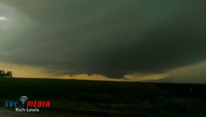
476ede7281467a5a28a0cf2f4b67c0d6.jpg
Sitting just NE of Colfax I get my first glimpse of the approaching supercell. This supercell had a beautiful base and a well defined wall cloud had already formed.
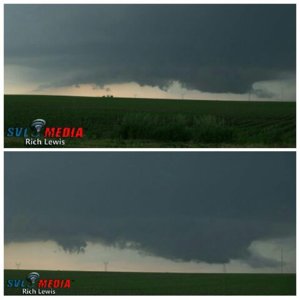
a85115003ce3df8f486ee6eb5debe0e2.jpg
I sat and watched this wall cloud for several minutes all while some intense positive CG's were occurring. It didn't take long for the wall cloud to start rotating rapidly.
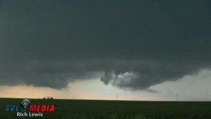
07aff57e15aa3528a7785eadebb2ea01.jpg
As the rotation started to tighten up, I got a glimpse of the first funnel cloud, a small slender needle seen protruding down in the middle. I knew it wouldn't take long for this storm to go tornado warned and as it got closer it started to take a slight turn to the SE, so it was time to repostition.
38412e56e54c81bee9b4b4bc4331e147.jpg
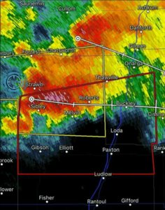
I tracked this supercell to Sibley IL Next where at approximately 4:30 pm. it would become tornado warned and it was game time. I had left Colfax and entered Sibley IL along Rt. 165. The inflow notch was incredible at this point and rotation really began to tighten up quite considerably.
47cb67eaf007118dea024af0a6e17604.jpg

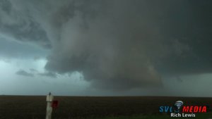
As I crossed Rt. 47 and shoot just south of Sibley I observed a 2nd rotating wall cloud that was really low to the ground. This storm soon would make another sharp turn more SE so I found myself crossing Rt. 54 and zig zagging the country roads from there south of Melvin IL. This is where things really got intense. This is also the point where the supercell began its transition into HP mode. At this point a well defined hook was becoming prominent on radar. I maintained a position just in front of the. Notch as I kept traveling south of Melvin.
0906ac445dabbe43379d3e8bb98ae0ed.jpg
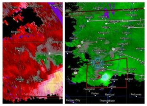
It was at this point the rotation tightened up enough to get the job done. A very nice couplet was just south of Melvin IL and I was directly in front of the very strong rotation.
3b923f1604bc5da20d8031e4bf6d8bf5.jpg
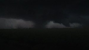
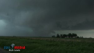
A few short moments later I found myself staring at a rain wrapped tornado passing just behind this farm house in a field directly in front of me. I would soon get pounded by strong RFD winds the surged in from my left hand side, quickly wrapping in another swath of rain curtains. While visibly it's hard to discern this as a tornado, a quick glance at GR2 Analyst revealed a debris signature with a 2.25 on NROT at the exact moment. There was something wrapped up in there.

Short video clip of the possible tornado.
[
All in all it was a very successful chase and an amazing storm for Illinois. Here is a full length video of the chase.

Sent from my HTC One_M8 using Stormtrack mobile app
 

Attachments

  • 1496021331791.jpg
    1496021331791.jpg
    42.7 KB · Views: 2
  • 1496021416146.jpg
    1496021416146.jpg
    77.3 KB · Views: 2
Do you have the actual time you saw the "tornado"? Not my proudest moment, but I ended up chasing a bit too aggressive with this storm because of the visibility I had prior to it going HP and ended up directly under the wall cloud around the time it was passing to the south of Melvin. I want to be sure of the timing because as of right now, all I ever saw while in close proximity to the wall cloud in that general area was just that: the wall cloud.
 
Should probably add CO and KS to the title.

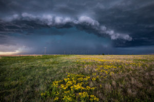
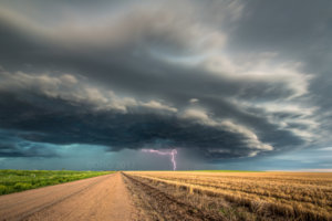
We chased the same basic area as the day before. Waking up in Oakley KS we went to our target of Byers Colorado. We jumped on the cells that fired up right on top of us. We had some great lightning at first and after awhile some very solid structure. We did see a brief tornado around Idalia again and a possible one at night in KS that was reported at the same time. Overall a day that was chase worthy and though it did disappoint on tornadoes it was a great day to see lightning and structure.

JDW_0848-2-Pano.jpg

SnapShot(23).jpg
 
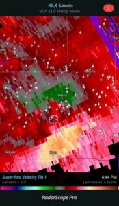
Devin, It was approximately around 4:45 pm or so or a few minutes shortly after. It was a run and gun type of situation So I don't have the exact time to the second. This screenshot was at 4:44 pm and it occurred just shortly after. 478379a7bf0515237708833f98211981.jpg

Sent from my HTC One_M8 using Stormtrack mobile app
 
Alright this is the video from my camera on my dash:

Video starts at 4:46pm CST when I realize the wall cloud is above me. There's nothing amazing visually, but it shows my perspective as I was heading east on E 900N Rd. At 4:48pm or so I started panicking because of how much the circulation had picked up above me. That was at around the intersection of E 900N Rd. and N 1000E Rd. so that does seem to correspond with the couplet location on radar. Once I finally got out ahead of it I was able to start driving South and observed the wall cloud to my West while not seeing any sign of a tornado and I was still well within half a mile of it at this time. It's possible the tornado dropped behind me briefly as I was escaping to the East but I never had a visual of it and rain was not obscuring my view at all at the time. This is eventually what the wall cloud looked like from inside the notch after the storm cycled afterwards and starting wrapping in rain again:
 
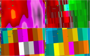
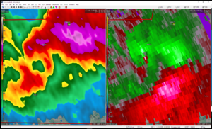
With the help of Jon Durr, I was able to correlate my position with a velocity scan at 4:49pm:
4320592c814d53c41.png


I did not see a tornado at that time. The circulation overhead was rather terrifying though.
 
Last edited:
I would call this my second real chase, both being in Illinois, and it went pretty well, except for not seeing the only tornado report listed on the NWS website.

I have had strong faith in the HRRR recently based on its verification rate and despite conflicting models the night before, I still felt the HRRR was going to get it right. Turns out it did. I would have to assume there was some luck involved in this because SPC took so long to introduce the 5% tornado risk, so there was clearly a reason to doubt it.

I met up with Glen Heinz and we chose to play the Bloomington area. This happened to later coincide with the western edge of SPC's 5% tornado risk. We felt confident that we didn't need to move West to intercept the cell while it was at the tail end of the line near Peoria. Meso-analysis showed we were in the more favored environment as well. We did have trouble deciding how far north or south to be because the storm kept changing its direction.

As a photographer first and chaser second, I tend to have difficulty with keeping up with the storm once I stop to shoot something. I did much better than my first time though. The storm tracks showed this storm moving slower than it appeared and there was lots of zig-zagging south and east to keep in ideal position. This storm was making wall clouds very frequently but nothing really formed from them. I only put in one report of a wall cloud for the photo below that is a more solid cloud than the others. I accidentally hit funnel cloud when I made the report, so a funnel icon appeared. Luckily I included the term wall cloud in the report so the mistake was clear to anyone watching. I continued to just follow along and mostly play catch up since I stop too long to take photos and watch.

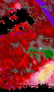
My chase ended as the storm moved across the border into Indiana. I was trying to stay within eyesight of the rotation on radar without getting cut off by precipitation. I had a lot of back and forth of being in rain and not in rain, but eventually I decided it was time to call it quits and went straight south. Turns out the storm did that too. Once the hail began, I headed west to escape the core and the rotation behind it, but after looking at my SN position after the fact, I didn't really avoid anything. There were three radar scans that showed me within half a mile three separate couplets that passed by, the strongest of which I included below. I included the VIL and VID products if anyone has any speculation on if it was actually a circulation or a downburst of some kind. At the worst, my visibility was about 20 feet and I head steady hail, none of which I thought met the severe criteria of 1", so I reported 0.88", nickle size, hail after I was in the clear. I described the conditions I drove through as a blizzard to some friends, it was windy and heavy with precipitation.

The oddest part of the day was that I had grass and other grass-like things stuck in weird places on the exterior of my car. Some blades of grass were stuck on some side windows and some grass got stuck in the wheel well covers of my front right and rear left wheels. It had to have been wind that did that because I would have had to be going in reverse to get them stuck in that position.

Overall I had a fun day and I traveled about 75 miles while chasing this cell.

I'll let the radar and still frames speak for themselves below as they have the necessary information to explain things.They are in chronological order. The second one is the same time as a rain-wrapped tornado was mentioned in an earlier post. I was SW of the rotation and I could not identify any features, as you can see in the photo.

2107z_2JD9913_1andhalfmile_radar.jpg 2137z_2JD9932_4andhalfmile_radar+pic1.jpg

2140z_2JD9939_mile_radar+pic1.jpg 2214z_2JD9965_1andhalfmile_radar+pic1.jpg 2235z_2JD_0026_1mile_radar+pic1.jpg 2322z_quartermile_radar.png
 
Started the day at work in Centennial, CO, undecided if I would chase based upon NAM. Within hours of the event, the HRRR was consistent in plotting a supercell just off the front range and tracking ENE - easy local chase for me. From previous experience, the majority of Denver Metro originating days relying on upslope flow and weak hodographs with storms tracking around Bennett, Byers, Wiggins end up an HP mess quickly, as well an annoying traffic jam. In anticipation of rapid junk out, left work by 1PM to get out ahead of initiation which occurred near Parker at 2PM. Tracking to near Last Chance, the storm finally organized enough to develop a decent meso. For the next hour it tried tightening, with one or two half hearted attempts to develop a clear slot, and some RFD gust ups pulled dust into the updraft fooling quite a few folks it seemed. Chaser convergence was horrible up close, of true circus proportions. I counted probably 20 tour vans and there must have been hundreds of chasers on the storm with long lines and most pulloffs taken. Got tailgated more than once by people too dense to position properly, and I do not drive slow. Quickly grew tired of the circus and fled to dry dirt south of the storm to work structure and actually enjoy the storm away from the mindless hook surfers - besides it was obvious this storm was not ingesting what it needed as it gradually turned more HP. Rest of chase was quite enjoyable once I got away from the horde.

_MG_7522.jpg

_MG_7639_edited-1.jpg
 
Devin, I actually saw your dash came footage on YouTube yesterday. I live in Paxton, so I'm very familiar with the roads you were on. Admittedly my timing may be off slightly. Cell service was in and out, so some of the screengrabs I saved may not have been updated to the exact minute. Give or take a few. More likely towards a few minutes after. All I know for certain is that between 4:44 and 4:50 was when that couplet came though and rotation was the strongest near Melvin area. Somewhere between then it passed right over me. Yeah if you were traveling east on E 900N Rd at the N 1000E intersection, you were still a bit west of the couplet. Though not by much. But as you progressed east, and turned south at the N 1100E and E 900N intersection, it would have been behind you slightly to your NE. Seems you were suspicious in your video as well as you even mentioned a tornado directly above you at one point lol. I'm wondering if there was a secondary area of rotation or circlualtion just behind you as you went east? Possibly just sw of the main couplet perhaps as it came from Sibley moving towards Melvin? I was to your north and east at the time as I zig zagged the roads south of Melvin. I was pretty close to the hook at the time I entered Melvin. I had just crossed Rt 54 and was going east along E 1100N rd where it intersects N 1100 E. That's when I dropped south and Continued east to the the N 1200 E intersection. If it was behind you as you turned south , you wouldn't have been able to see anything. Don't think of a traditional stovepipe or come tornado. This was small slender "birdfart" vortices that were touching down. Visually in the video I shot, you only see just the edge of the wall cloud which which is why I have labeled it a "possible" tornado. However one of these vortices was likely wrapped up in there at the time based off the NROT signature. And I have never personally witnessed rotation that rapid from just a wall cloud. When the RFD surged in from my left it was insane. Never have I seen rain curtains wrap around so quickly. Which is why I'm suspicious something more was occurring. Even the returns that Jon provided are impressively convincing. That's what was attributing to the extremely strong rotation you yourself experienced. These vortices were getting wrapped up in the rain curtains almost instantly and it was hard to pick them out from the rain curtains being wrapped around by the RFD. The first of these were actually reported near Alvin, before the tor warning was issued. Another chaser actually got a few of these vortices as he was at a better vantage point and not escaping the surging RFD and wrapping rain curtains as we would have been. These are just a few that he captured.
20944fd95b2b33a045df326a0839989e.jpg
e7a2c5d0f910e98b6c9bbc443e2d5153.jpg
These vortices actually continued to the east to near Hoopston and Rossville before the 90 to 100 mph straight-line winds took over.

Sent from my HTC One_M8 using Stormtrack mobile app
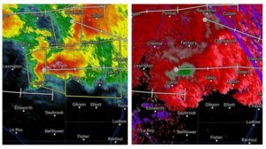
 
Yeah I was aware of the Tornado that was reported near Rossville, couldn't see that one because I was behind a grove of trees and trying to escape the RFD that was quickly filling with hail. I was just really confused over the Melvin one with me being so close to the wall cloud at the time. As I turned south I was able to get a full visual on the wall cloud with no sign of anything under it, it would have had to drop while I was making my way out of there.

Lemme tell you though, I wont be making that positioning mistake again. After seeing that thing crank overhead like that, that was enough.
 
I hear ya! I got caught by the RFD more than I should have. Lol. From my vantage point even the wall cloud was partially rain wrapped when all that occurred,i but seconds later the whole wall cloud wasn't visible anymore. So it's very possible it did happen after you made your escape because a clear view of it would have been hard at that point. I'm assuming you as many others raced east to stay ahead. I stayed back in the bears cage to see what was happening. My video only shows half of what occurred when the circulation was wrapping up. I wanted to stay and film some more but the RFD was wrapping those rain curtains in at warp speed and revolving 360 degrees around then whole wall cloud at an incredible rate. That's when the whole thing disappeared and the winds really picked up after a sudden wind shift. I overstayed my welcome and escaped at that point. Didn't need to stick around and see what was causing that. Staying behind cost me getting back in front ever again. And once I got to Paxton I aborted the chase. I was already at home and needed to get my video uploaded and sent in.

Sent from my HTC One_M8 using Stormtrack mobile app
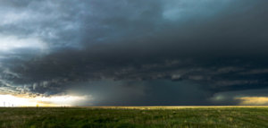
 
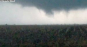
his was an amazing chase day where the storm structure was the highlight rather than the brief tornado. I started the day in Burlington, Colorado . The high resolution computer models were consistent and in agreement about supercell development somewhere just east of Colorado and eastward motion toward Kansas, My initial target was Bennett, Colorado which is just east of Denver International Airport. The town had a north road and easy access to another east option north of the interstate. I headed west, and with the 75 miles per hour speed limit, I easily made the trip. I walked into the truck stop and immediately ran into Jason Persoff. I meant to call Jason when I arrived, but he had already reached the target area. There were already some storms developing to the west. I had a brief lunch at the McDonalds and then met Jason out back along with some other storm chasers. There was a dead end behind the truckstop with a nice view to the west. In the brief time I had lunch, storms exploded overhead and to the west. The individual updrafts were struggling. There were no landspouts as Jason had hoped. As the storms shifted eastward, Jason and I followed along I-70 and then 36. We would stop occasionally to take photos if there was some interesting foreground. Chaser traffic was not bad; however, pull-offs with a nice view/foreground and space were a bit difficult to find. We ran into another chaser friend, Chris Collura and later Cloud 9 Tours with Charles Edwards. The storms were intensifying especially the one just north of 36. We could just follow along 36 to the east. Unfortunately, other road options were limited. At the town of Last Chance, we headed north to get in front of the storm and then take a closer east option at Woodrow. The main storm was starting to show signs of rotation. At the east option, we discovered the road was gravel. The storm was bearing down on our location with declining visibility and hail. We had to backtrack south. As we got out of the rain, we noticed that the back side of the storm was intensely rotating and forming a wall cloud at 4:08 PM MDT. The storm motion was insane. I set up my larger Sony Z1 on a tripod outside to capture the motion by CR 21. A tornado seemed imminent. The storm was already tornado-warned. Smack. We were blasted by RFD winds, and my Z1 toppled over onto the pavement smashing the viewfinder. I threw it in the car and continued filming with the other camera. We followed the storm eastward on 36. It was to our north. No tornado but the structure was amazing. The storm was becoming a massive beast of a supercell. In Anton, we ran into Matt Crowder who is a retired meteorologist from The Weather Channel. We filmed the storm further west. I checked on my camcorder. The eyepiece viewfinder was smashed but the flip out screen worked and the camcorder seemed to function. The storm was intensifying and starting to turn right. This would give the storm more helicity but also bring it toward us along the east-west road. We passed through the picturesque town of Cope with pretty little houses. The place seemed to be rapidly becoming a ghost town. Someday, I’ll have to return just to take pictures and explore. Just west of Joes, we turned north on 59 and briefly parked at CR 8 at 5:38 MDT. The storm was amazing with some suspicious lowerings. When it was too close, we dropped south and continued east on 36 trying to keep ahead of it. The storm was crossing the road behind us. Just past Idalia, we turned south passing in front of the storm before it could cut off our south option. At 6:45 PM MDT, we could see a brief white poor-contrast tornado to the west from 385 south of Idalia. We were in Yuma County. The tornado was gone by the time we stopped. At I-70 in Burlington, Colorado, we turned east. The storm, which was to the north, was now moving more easterly. It was massive and covered the northwestern sky with beautiful striations. We followed it into Kansas. As night arrived, I said goodbye to Jason and headed east to Salina for the next day’s positioning. The tornado was unimpressive, but this was a wild and very successful storm chase as we followed a long-lived tornadic supercell and obtained great images and video.

Images


I ran into Jeff and Kathryn Piotrowski who are excited about the forecast 8500 CAPE the following day (Saturday)

http://www.harkphoto.com/052617jeffkathrynIMG_4158.jpg

Jason Persoff is ready for storms

http://www.harkphoto.com/052617jaosnreadyforstormsIMG_4173.jpg

Cool lightning

http://www.harkphoto.com/052617lightningIMG_3989ad3.jpg

Chris Collura drops by to say hi in his armored vehicle

http://www.harkphoto.com/052617chriscolluraIMG_4182ad.jpg

Nice wall cloud. It almost produced a tornado

http://www.harkphoto.com/052617wallcloudWPDSC_3676ad.jpg

I am posing in front of the wall cloud

http://www.harkphoto.com/052617BillwithstormWP.jpg

Really cool storm structure

http://www.harkphoto.com/IMG_4194adforW.jpg

Jason and Matt Crowther watching the storm

http://www.harkphoto.com/052617stormchasersWPdsc_36940873ad.jpg

Farmhouse with approaching storm

http://www.harkphoto.com/052617stormfarmhouseWPdsc_36950874ad2.jpg

Superwide view of the storm

http://www.harkphoto.com/052617superwideview20170526_183728ad2.jpg

Beautiful storm

http://www.harkphoto.com/052617stormWPdsc_37080875ad2.jpg

Storm at 5:38 PM MDT

http://www.harkphoto.com/052617watchingstorm538MDTIMG_4001ad.jpg

I love the blue hail core.

http://www.harkphoto.com/052617stormWPdsc_37220876ad.jpg


There is definitely some big hail in there!

http://www.harkphoto.com/052617stormforWebIMG_4258ad.jpg


Bill Hark


Back
Top