Jesse Risley
Staff member
The ECM and both American models are consistent in propagating a stout H5 perturbation across the mid-Missouri valley on Wednesday, with H5 wind speeds AOA 90 kts. There are some slight differences in regards to the position and timing of the shortwave, but the models are coming into better alignment. It is worth noting that guidance has previously differed in regards to the timing of this wave in conjunction with the associated surface features, ongoing convection or lack thereof, and resultant destabilization in the warm sector.
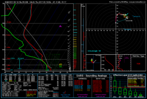
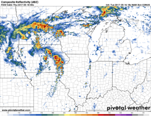
Today's NAM looked particularly intriguing with regards to favorable instability in western IA, northern MO and eastward into parts of western IL, though the GFS continues to depict miserly instability profiles. Nevertheless, this is one to monitor, as a surface cyclone looks poised to orient itself near KSUX and deepen slightly, before moving east across norther Iowa.
If the warm sector destabilizes with greater preponderance than that which has been depicted, shear profiles are ambient for a damaging wind event, as signaled by some CAMs, including higher res NAM products. Notwithstanding, I do still see a brief window of opportunity for a yet to be determined tornadic threat, of at least an hour or two, ahead of the main forcing and across the western portions of the warm sector. Embryonic convective development may remain discrete across portions of far NE KS, far SE NE, NW MO and SW IA, taking advantage of a seasonably modest instability profile, favorable 0-1 km shear profiles, and the presence of the boundary somewhere INVO I-80 to US 20. However, overall, that looks to be largely propitiated by otherwise unidirectional wind profiles, which suggests the possibility of an enhanced wind damage threat, depending on the evolution and degree of instability, juxtaposed with otherwise ambient bulk shear profiles.
I suspect this will vacillate between now and Wednesday, with the biggest unknown being overnight and morning convection and the resultant impact on the warm sector, as well as the evolution of wind profiles to a more or less favorable degree to enhance tornadogenesis potential.


