Quincy Vagell
EF4
I started the day in the Texas panhandle, but opted to not go to Colorado for a variety of reasons. The main issue for me was the lack of favorable wind speeds aloft, i.e. only 15-20 knots at 500mb and poor low level shear. Despite the Denver cyclone setup, it didn't look to me like a Simla or Wray-type setup. While there was definitely enhanced low-level vorticity, 0-3km CAPEs were lackluster and T/Td spreads were not particularly favorable. (I would have liked to see dew-points a few degrees higher)
So, I gradually made my way into eastern New Mexico and convective temperatures were reached by about 21z as agitated cumulus fields gave way to quickly organizing updrafts. Unless it's a local chase, my chase style is to aim for discrete storms and structure over the outside shot at a brief tornado in an otherwise marginal/messy setup.
In Fort Sumner, a pair of hail producing thunderstorms passed by, with the latter moving right through the middle of town with dime to nickel-sized hail. Once the storms passed, I moved east to parallel the storms back up with the generally S-N route to Tucumcari. Near House, the hail core expanded east and I found myself temporarily fighting with golf ball hail before NM-252 took a hard right, sparing my vehicle.
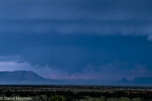
While paralleling the storm, the storm showed better signs of organization, but still had a fairly elevated look. Nonetheless, the storm interacted with an apparent boundary and showed, intermittently, better low-level rotation. Aside from a few brief funnels, that was about all that I can report on that front.

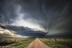
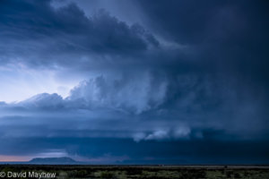
Near Quay, a more favorable road network allowed me to get fairly close to the storm, but I kept just enough of a distance to capture some pictures and videos of the storm at a wider angle.
I did not witness a tornado, but this will go down as one of my better New Mexico chases. I didn't have very high expectations at the start of the day, but there was plenty of structure with some relatively long-lived supercells.
Video of the latter part of the chase, sped up to 16 times the actual speed:
So, I gradually made my way into eastern New Mexico and convective temperatures were reached by about 21z as agitated cumulus fields gave way to quickly organizing updrafts. Unless it's a local chase, my chase style is to aim for discrete storms and structure over the outside shot at a brief tornado in an otherwise marginal/messy setup.
In Fort Sumner, a pair of hail producing thunderstorms passed by, with the latter moving right through the middle of town with dime to nickel-sized hail. Once the storms passed, I moved east to parallel the storms back up with the generally S-N route to Tucumcari. Near House, the hail core expanded east and I found myself temporarily fighting with golf ball hail before NM-252 took a hard right, sparing my vehicle.
While paralleling the storm, the storm showed better signs of organization, but still had a fairly elevated look. Nonetheless, the storm interacted with an apparent boundary and showed, intermittently, better low-level rotation. Aside from a few brief funnels, that was about all that I can report on that front.
Near Quay, a more favorable road network allowed me to get fairly close to the storm, but I kept just enough of a distance to capture some pictures and videos of the storm at a wider angle.
I did not witness a tornado, but this will go down as one of my better New Mexico chases. I didn't have very high expectations at the start of the day, but there was plenty of structure with some relatively long-lived supercells.
Video of the latter part of the chase, sped up to 16 times the actual speed: