2017-04-21 EVENT: KS/OK/MO/TX

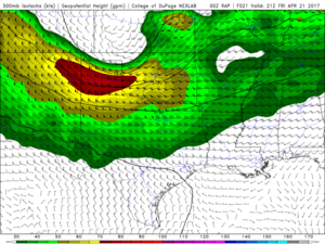
Well looking there. The 3km NAM trended toward the RAP. WOW! I wonder if the trend will continue. As Jeremy said 3km NAM is lighting it up along I-35 corridor tomorrow aftrn. This will be interesting to watch unfold. The RAP has the 500 jet streak coming out pretty perfectly. And a nice WF draped across I-40. The HRRR is taking convective outflow and pushing it toward the Red River. But even that is showing signs of stalling. All eyes on the mesonet maps tomorrow.

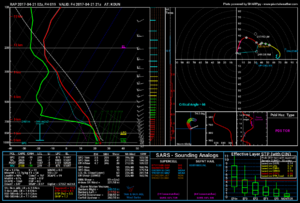
Look at this beautiful 80kt jet streak
715abeb75baef40cb7831401fe9c7cd3.png

c2043752e2d29687d53b6daddf61782a.png

All in all there is at least still hope. Although, I won't be upset if it doesn't happen. I have thunder tix and don't want to be late.
 
IDK, it still looks to me lke the 00Z NAM has the front really far south throughout tomorrow. The only change I see is that it miraculously veers the winds in a 200-km stretch of SC OK, bringing a theta-e tongue in just in time to get storms to form before the CF quickly blows through. Definitely a mesoscale subtlety to keep an eye on, but I have doubts that it will materialize that way.
 
Based on recent trends, I'd expect a morning MCS to blow through Oklahoma from NW to SE and force the instability axis down toward the Red River or even into North Texas. It's going to be hard to recover with northward extent across Oklahoma, especially with a cold front racing through.

There will still be subtleties to watch and mesoscale nowcasting, but what once looked like a possible I-40 threat is now threatening to be down near the Red River. Who knows if HRRR is overheating the boundary layer, but the latest run shows CINH eroding across North Texas by 20z.
 
The most recent HRRR runs are not adequately capturing the existing convection across OK. They also all tend to blow an OFB through as the cold front very early, and the only real threat ends up in SE OK or into the jungles of NE TX/W AR. The 11Z HRRRX, on the other hand, seems to do a better job evolving the ongoing convection. It progs a few supercells along the front along and just south of the Red River, N/NW of the DFW metro, later this afternoon. I tend to trust that solution a bit better as of this moment, but this is a day where you will need to be constantly monitoring new observations as they come in to see where the front is and which areas are seeing the most heating.
 
MCS plowing through Oklahoma right now with a surging outflow boundary in SW OK approaching the Red River. Definitely a day to favor surface observations, radar and mesoanalysis over models that are already having a very tough time in the immediate near-term.

Either way it's not looking too likely for appreciable airmass recovery with northward extent north of the Red River.
 
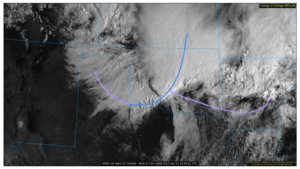
Here's the morning satellite image with the boundaries drawn in. Purple represents stationary boundaries (not occluded fronts) and blue is advancing cold air.

srnplains_02_20170421144522.jpg

The south end of the cold front isn't being reinforced by convective outflow, so I expect that to stall out along or just south of the Red River this morning/afternoon. It might even be lifted a bit farther north once the jet kicks out this afternoon, but that's some cold air behind that boundary. Temperatures in the low 50's F, and they probably won't be modified much without sunlight. This isn't the kind of outflow boundary you want a storm to ride.
 
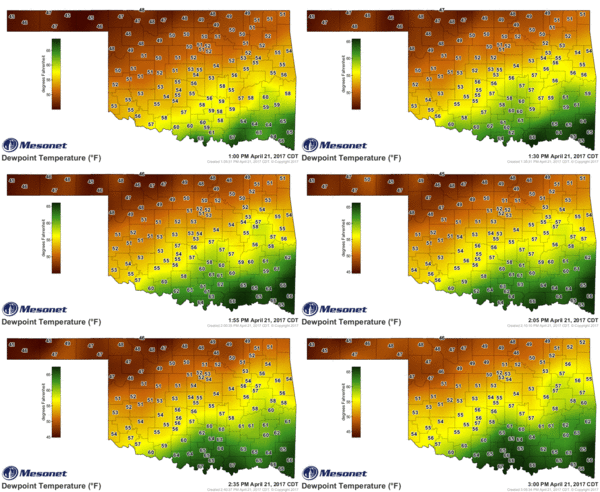
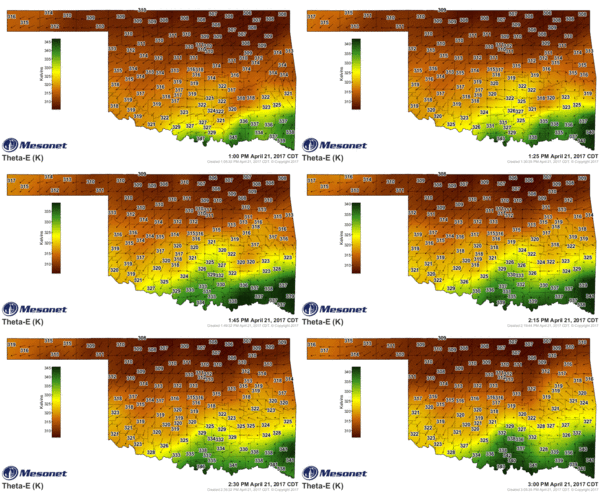
The warm sector is expanding into southern OK. I have added my ThetaE and Dewpoint mesonet loops. 19z HRRR and 18z 3km NAM break out some storms along I35 south of Pauls Valley.

24663502061088dbd91c90b9f6fd3a73.gif

5f13542444057c3ac95793114d5e26ec.gif
 
Still holding strong behind my decision to sit this one out. Visible satellite as of 3:30PM shows the front draped across Northern Texas into Southeast Oklahoma. Looking at the GOES-16, it still looks to have a tad southeast component to it. HRRR is showing developing along this corridor this afternoon/evening moving southeast. I expect large hail (perhaps 2+ inches) to be the main threat along with a growing damaging wind threat with eastward movement. Tornado threat is there definitely with any early storms that can go up, but as mentioned above, this isn't exactly a boundary that would favor a classic tornadogenesis type situation. It screams upscale growth to me. We see a lot of these in IA/IL in June/July and that is usually what happens lol. If I were chasing, I would probably be sitting somewhere from Gainesville to Sherman just east of I-35 and see what can fire later on ahead of that boundary.
 
Post-mortem

Don't doubt the NAM. I went back and pulled previous forecasts and compared them to observations at 21Z and 00Z. The NAM's southerly cold frontal position tended to be closer than other models putting it further north. In fact, if anything, even the NAM wasn't bullish enough with it, as many forecast cycles had it too far north compared to where it actually was:

Cold front at 00Z

Cold front at 21Z
 
Back
Top