2017-04-21 EVENT: KS/OK/MO/TX

Joined
May 6, 2005
Messages
288
Location
Moore, OK
Overview

The GFS has been hinting at a negatively tilted trough sweeping the plains on Friday for a few runs. Exact details are still evolving. But, both GFS and ECMWF put this trough across the OK/TX region. Latest 00z (20170418) GFS looks rather favorable. Timing seems to line up well with peak afternoon heating.

Surface

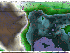
At the surface plentiful moisture should be available with the Wed system pushing only to the OK/TX border. By 21z there should be upper 60 Tds throughout the warm sector. While not definitive on placement yet, there will be cyclogenesis somewhere from SW Okla to perhaps SW KS. This is aid in backing surface winds to S and possibly SSE at 20kts.
f4a0a0c0f0f44df3971db2bab67ef83a.png

Upper

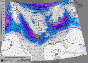
500 hPa trough ejects over OK right around 21z. 7-5 LR of 8.5° C/km combined with substantial surface moisture will lead to strong instability approaching 3,000 MLCAPE. There is beautiful diffluence at 250 hPa (nearly 90°)
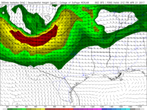
0fc3da43ac30408d1380465d41f10375.png

At 850 hPa the LLJ isn't particularly strong the previous night but begins to ramp up between 18z and 21z day of event. By 21z winds of 35-40 kt form the SSW at 850 hPa will be common across the warm sector. By 00z there will be widespread 0-3km helicities of 250+ m2/s2.
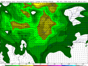
3dccf6e5d3670e0cdbaab31e92369e32.png

Conclusion

Still lots of uncertainty with this forecast as it keeps changes from run to run. It seems ECMWF has been more consistent with the 500 trough than the GFS. But every few run the GFS paints a rather ominous picture. Will be interesting to see the 12z NAM on 4/18

Special Treat

A PDS Tornado sounding for KOUN right before the OKC Thunder game in OKC!!!
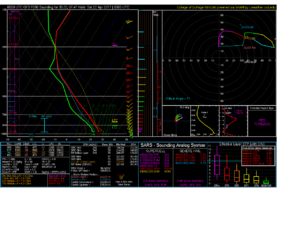
89882447b060eead4a3bc33594643fbb.png
 
This one looks like the first potentially "big" day, however you may define it.

Thursday eve into overnight hours as the initial Weds wave makes its departure east, and the primary Friday wave begins to dig/amplify into the Rockies, surface mass response will begin to retreat a warm front to the north. Southern OK looks to be sitting in mid-60s dewpoints by the early morning hours. Warm front seems likely to be north of the metro by mid-late morning, and convective precip north of the WF should keep it there.

70+ knot speed max in the midlevels and associated closed, compact wave will offer strong low level response, and this gets things going fast. By 18z an environment conducive for supercells looks to shape up. Recent GFS runs have a volatile environment in west and central OK by as early as 21z, with effective SRH ranging from 250-400 m2/s2 and deep-layer shear pushing 50 knots. Given this, it would appear that tornadic supercells, with a GFS verification, would be likely, and potentially long-lived at that. Deep-layer mean flow with a strong westerly component and shear vectors more westerly will favor discrete convection. Mode probably gets messy near and shortly after 00z with such strong forcing + cold front advancement.

Usually a setup like this has me worried about early initiation, but even by 18z the environment looks conducive for supercells. Rapid organization seems likely with this event.
 
Last edited:
The GFS control member has remained roughly consistent with the upper level features of this system as time has drawn closer. I've been looking more at GEFS ensemble members now that CoD offers such a view. The members are definitely converging on the control member forecast for upper level features. However there is still substantial phasing uncertainty. Some members from overnight's ensemble still show the trough axis east of I-35 by 00Z. The Canadian ensemble has more spread than that even. The members don't even agree on the presence of a trough, and there are still significant differences in the location and orientation of the trough axis (all three modes and positions [negative, neutral, positive] and [west of plains, over the plains, east of the plains])

What I don't like about this setup is the surface pattern. It looks very cold fronty. It appears a lot of cold air is going to build up north of the cyclone across the central and high plains, much of it caused by persistent cloud cover and upslope generated precipitation across KS/CO throughout the day. And since it's still April, this cold air has a lot of budge factor, really trying to shunt the warm air south and punching a cold front south even on the lee side of the upper level trough, which seems pretty unusual. Also, there is an issue with persistent precipitation along the warm sector and possibly in the warm sector, thus also helping to shunt the warm sector further south or just flat out washing it out. As a result, instability is spotty and lower than you'd think given the decent low-level moisture quality.

Deep layer shear looks good. I don't see much of any anticyclonic hodograph curvature in this system. The early-day crapvection does screw around with the low-level hodographs a bit, so this event is highly conditional on not only how much cold air develops north of the front but how much convection develops and covers up the warm sector, and thus how much destabilization actually occurs.
 
Man Jeff Duda- do you work for the SPC, lol? Your analysis is almost a copy of what the SPC outlook said overnight for Day 3.
The 3kmNAM is now within range and I don't like it. It shows basically a strong cold front surging south through Oklahoma with no real warm front/triple point setup. Some storms form later in the afternoon but in the jungle of eastern Oklahoma right along the cold front which would probably mean more of a wind/hail threat.
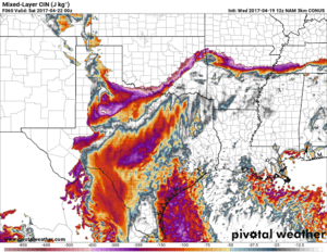
The GFS still is holding strong on it's more of a triple point scenario and storms in central OK down to the Texas border it seems. However, the best CAPE and wind shear are further south in Texas. Another concern with the GFS is for example on the 12Z today, it shows a pretty stout cap in the warm sector where the best indices are for tornadoes, so not sure anything would fire in that best area.
I want to chase this day, but it's a long trip and hopefully things will become more clearer by tomorrow afternoon when I would need to make a decision.
 
I've been watching this day since it came into range on the GFS and like many of you have been not been as excited about it over the last few days. Over the last few days I had many of the same thoughts as you all did ("cold fronty" and "sure hope today's 3K NAM is wrong"). Yet with ever run of each model I still find very believeable TOR soundings with good analogs, although capping has started to make me question many of the recent forecast soundings. It looks to me like there is a narrow corridor where the cap could go (and this is consent across every in range model I looked at). As of now I expect to be chasing in TX and hoping the cap breaks. That could change (over the last week I have gone from TX to OK back to TX on this system).

mlcin_us_sc.png
 
Perusing the GFS and NAM for this event this afternoon and have a lot of questions, and perhaps some answers. The GFS has been rock solid consistent since Hour 108 with it's placement of everything. If the GFS verifies (and is my preferred solution, which is probably some wishcasting) we could see some really good hoses across OK/TX on Friday. If the NAM verifies, we're going to forget the day as quickly as it came.

Some interesting thoughts though:
1. The cold air rush seems to be coming from the Pacific Northwest. The air up there is quite saturated per 12Z soundings and seems like a pacific maritime airmass of some sort, and not a dry cold front. So I bring into question about how cold the air will actually be behind the cold front, and how fast it'll come sweeping at us. Seems like there may be some differences in reality vs simulated reality (models) on that. Then again, remember, cold air always wins.

2. Seriously, the GFS is consistent run to run, including 06 and 18Z runs for a couple days now. Like almost 100% consistent.

3. SW850s should not be a problem and might even be good. The moisture streamlines seem OK, so the GFS solution does not ingest dry air at that level and blow dry your storms. In fact, the 850s are parallel to the dryline, which should allow your storms longer time in the dryline circulations before leaving the level of free convection and being steered off the boundary.

4. The upper jet streak seems almost perfectly timed by either model.

5. Capping seems like enough to keep things discrete, but not too much to keep things suppressed.

6. No Veer backing in the GFS solution.

There is definitely a predominantly down side, but it could be a real good day as well. Luckily for me, I live in Norman and will be able to make a decision on Friday morning or even early Friday afternoon
 
This is one of those rare cases in which I won't (by default) prefer the hires NAM to the GFS. The RGEM is much closer to the GFS and shows a surface low passing very close to OKC at 00z SAT with a warm front-like boundary draped W-E near I-40. The Euro is more of a compromise between the two "extreme" solutions.

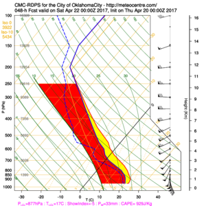
Before I post the 00z OKC RGEM forecast sounding, I want to make it clear that this is likely one of those setups that doesn't come into really clear focus/reasonable confidence until the morning of. So many things can adjust the mesoscale setup, including, but not limited to: early day convection, effective warm front position, any outflow boundaries, capping (or breaching of cap into N TX), speed of cold front and orientation of shear vectors WRT cold front/dryline.

Modify this RGEM sounding for areas just E/SE of OKC and that spells big trouble.
DDBBED41-54EC-438C-A526-BB0F53C2CBAC-2405-00000221B6C6BD5A.png
 
NAM seems to be getting more aggressive with the cold air intrusion/crashing cold front. This morning's 12Z run didn't even develop a surface low (which I find hard to believe ahead of this jet). I'm not sure what's driving this sudden shift other than an unresolved feature that I'm not finding as the jet max is just nudging into Oklahoma and the front is already down past Wichita Falls.

d646a2096a4a50611fe462e1c23cf9cc.png

f835ba7cc522569df56bffb406b04cab.png

The 00Z GFS and Canadian runs from last night seem far more moderated, with a 1000-1004mb surface low developing in the late morning/early afternoon in the Red River Valley and gradually moving ENE with the entrance of the trough from the west. Moisture on all three aforementioned models seems pretty believable given observations and current conditions with more moistening overnight, leading to easily mid-60F dewpoints. Assuming some blend of the GFS/Canadian/Euro is to be believed, the best shear/MLCAPE combo is looking to set up in N TX along the river with deep-layer shear values around 40 knots, gradually enlarging hodographs (0-3 SRH increasing to well over 400 m^2s^2) and MLCAPE in the 2500 j/kg region.

Overall, if the NAM solution fails to pan out, I'd venture to bet the N TX/S OK area gets some beefy supercells with those kinds of conditions. There'd simply be too many things going for the setup to not pan out (famous last words). I'm still skeptical of the NAM, which may just be blind optimism in the face of an April 2013-esque setup, but I can't imagine a scenario where we don't even have cyclogenesis.
 
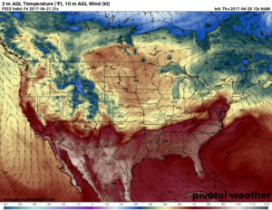
I'm pretty convinced the cold air is going to win and this is going to end up pretty much as a non-event. Previous forecasts showing the aggressive southerly position of the cold front currently are on track compared to other forecasts. Plus most of the high resolution models are very confident in the cold front sinking to about the Red River and really not retreating at all tomorrow. It seems the lack of retreat is largely due to convective reinforcement, as a heavy rain event appears likely over much of Oklahoma this evening and overnight, the outflow from which will do a lot to keep the front south. It seems the GFS's more northerly frontal position is slowly converging towards the NAM's more southerly frontal position. But even if the GFS ends up being right, the front is still going to be quite far south, mostly out of the path of the great shear.

Ugh, on to next week.
 
Yeah probably going to sit this one out tomorrow. It kinda reminds me of April 17, 2013 (a day in which I saw 2 weak tornadoes in SW OK/NW TX), but worse in the sense of the advancing SE cold frontal boundary and heavy rain event ongoing to the north. I could see an area in Southeast Oklahoma/perhaps down into Texas that if the cap gets breached toward 00z, there could be a tornado threat. However I'm not extremely confident in that just yet for a 9+ hour drive.
 
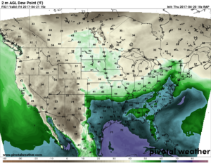
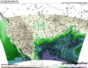
the 18z RAP shows a possible glimmer of hope. But still this forecast is so messy, I fear we won't really know much of anything until tomorrow morning. It has the wf further north and doesn't show as much reinforcement from morning convection. By 15z friday it shows 2000 sbcape in S OK near red river. And another positive is it has the 500 jet streak further west. So maybe just maybe.

Edit:
Here are the Td plots

0d886348a82d9b39570b0891386196a0.png

41c14907efa835c0b81ddd6f902351df.png

Also, i had no idea pivotal ran the RAP hourly. Very nice, although i like the COD zoom in of S Plains.
 
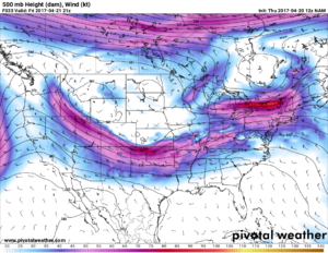
Awaiting the latest 00z guidance, the RAP continues the trend of being the most favorable for tomorrow. It promotes a window that would exist across Southern/Southwest Oklahoma by mid to late afternoon of enough destabilization and low level shear to promote a potential tornado threat. Too bad its a cold front that is draped E to W across Central Oklahoma and not a warm front lifting northward....because there is a rather beautiful 70 knot H5 jet that is about to round the base of the trough out of New Mexico into Western Oklahoma by afternoon tomorrow if the RAP is correct. This model so far and to some extent, the GFS, are what is keeping me on the fence about chasing tomorrow. All other guidance seems to show a sweeping cold front all the way down to the Red River and a flash flooding event for areas near I-40/44 tomorrow afternoon/evening. Not to say there isn't a couple tornadic storms mixed in there somewhere over Southeast OK/Western AR ahead of the morning complex by afternoon, but they probably won't be anything "chaseable" compared to something that might pop up further west given the adequate instability/shear combination, that actually occurs.

d43245f27298f0f96e1067952d8e8b7b.png
 
Awaiting the latest 00z guidance, the RAP continues the trend of being the most favorable for tomorrow. It promotes a window that would exist across Southern/Southwest Oklahoma by mid to late afternoon of enough destabilization and low level shear to promote a potential tornado threat. Too bad its a cold front that is draped E to W across Central Oklahoma and not a warm front lifting northward....because there is a rather beautiful 70 knot H5 jet that is about to round the base of the trough out of New Mexico into Western Oklahoma by afternoon tomorrow if the RAP is correct. This model so far and to some extent, the GFS, are what is keeping me on the fence about chasing tomorrow. All other guidance seems to show a sweeping cold front all the way down to the Red River and a flash flooding event for areas near I-40/44 tomorrow afternoon/evening. Not to say there isn't a couple tornadic storms mixed in there somewhere over Southeast OK/Western AR ahead of the morning complex by afternoon, but they probably won't be anything "chaseable" compared to something that might pop up further west given the adequate instability/shear combination, that actually occurs.

View attachment 15567
There is always a chance all the models are wrong. I think we just have to head to bed and wake up and see what the morning brings. I'm gonna fire up my mesone loops tomorrow to track the possible wf.

Sent from my SM-G920P using Stormtrack mobile app
 
Yepp. I will be sitting this one out. A 9+ hour drive is on the line, too much to gamble in my opinion. If it were more local, I'd be more enthused. Always next week....
 
And of course the 0Z NAM models have now adjusted towards the GFS. Don't have the cold front crashing as fast and the 3km shows storms in the warm sector in sc Oklahoma and nc Texas with some decent helicity tracks in Oklahoma. 12kmNAM also has more of a classic warm front/ triple point look too. Since I called of the chase already, I'm sure there will be tubes[emoji4]


Sent from my iPhone using Stormtrack
 
Back
Top