Ethan Schisler
EF5
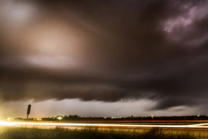
I ended up chasing this day, which kinda turned into a mistake. I anticipated a solid warm front setup across Southeast Nebraska into Southwest Iowa with my morning forecast. Excellent amounts of instability, good low level backing winds, and high levels of low level shear excited me for the prospects of tornadic supercells in this region. I got out to Omaha around early to mid-afternoon in time for supercells to fire about 50 miles to my SW. It became apparent early on though that the cold front was advancing way further east and faster than models were showing. So while intense supercells were indeed developing as forecast, they would stay a few miles behind the boundary retarding tornadogenesis. I eventually went east of Omaha and got onto I-80 where some storms were trying to develop along the warm front and ahead of the cold front. I followed these cells further east and they started dying and it became evident by about 7pm that it was probably a classic ole Iowa bust. A capping inversion on the Topeka sounding at 00z and the issues with the cold front, put the brakes on what was an otherwise solid setup. Anyway for the report portion....I continued east toward Des Moines where I noticed storms to my NW intensifying after-dark and eventually going tornado warned near Carroll and Boone, Iowa. I intercepted this embedded supercell outside of Boone, Iowa just as the tornado warning expired. Supposedly it produced a tornado earlier on near Carroll, I did not see it. The structure was pretty decent though, I only had my 24-85mm with me, so I wish I had brought my 14mm to fit the entire thing in. Cloud to ground lightning was pretty much lacking though. So I did pull off a decent shot on a day that pretty much fell well beneath my expectations lol. Oh well, you can't win if you don't play as I always like to say. But I still hate Iowa and I hate cold fronts lol. Unless its July.....then why not.

The "storm of the day" ended up forming well southwest in Central Kansas. I will be looking forward to any reports that anyone who chased that storm has. Looked like some fairly nice structure for Mid-April.

The "storm of the day" ended up forming well southwest in Central Kansas. I will be looking forward to any reports that anyone who chased that storm has. Looked like some fairly nice structure for Mid-April.
